
undefined
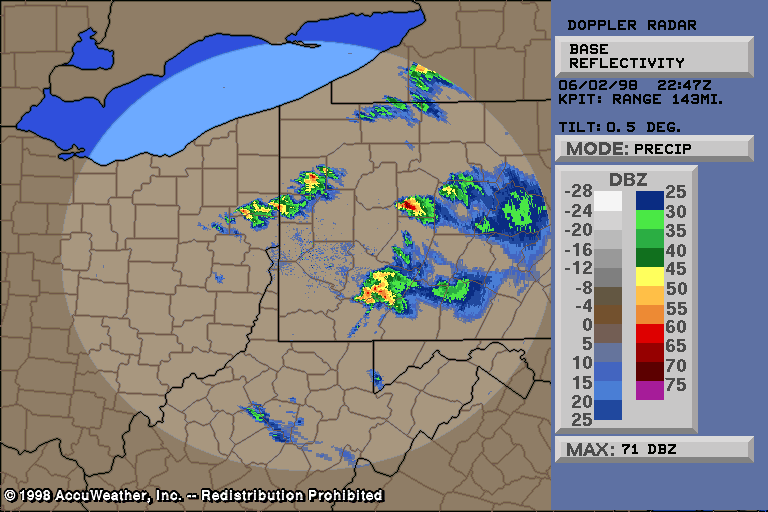
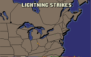
June 2, 1998 Tornado OutbreakAfter Sundays violent storms, Pennsylvanians couldn't imagine storms even worse, and didn't even want to think about it. They weren't even finished cleaning up from 2 days ago, and thousands were still without power. Within three days (May 31 - June 2, 1998), PA had a couple years worth of tornadoes. Also, the magnitude of both outbreaks is what would normally be seen every several years.... but there was two in just a few days! The SPC had PA in a moderate risk ( graphic / text) for severe weather, which is unusual, as most severe weather occurs in slight risks. These risks tell, roughly, how much of the area should be affected by severe weather - not necessarily the intensity of the thunderstorms (but it often reflects it). As is the case with many severe weather outbreaks, the morning started out mostly sunny. However, with daytime heating and an unstable atmosphere, cumulus clouds grew by late morning. By afternoon, many of the cumulus clouds were swelling to great heights, and in turn, becoming thunderstorms. The surprising thing about this outbreak is that the low level moisture in the atmosphere was not very impressive much of the day, as dew points were relatively low. The dew point is used to measure the amount of moisture present. Temperature wise, that morning was exceptionally cold for June, with some of the northern tier counties of PA dropping into the upper 30's! The low at my house was 44. Dew points that morning ranged from the upper 30's in the north, to the 40's in other parts of the state. For "good" thunderstorms to develop, you need higher dew points than that. With a southerly flow by afternoon, both dew points and temperatures climbed, reaching the low 60's and low 80's, respectively. Once the dew points got to the low 60's, then everything was in place for thunderstorms to develop. CAPE's were high, LI's were low, and the upper level winds were impressive. By having southwest winds at the surface... bringing in moist air... and northwest winds in the upper atmosphere... bringing in dry air... we had significant wind shear over PA. Two tornado watches were issued by the SPC in the mid to late afternoon for all of PA, and surrounding areas. NOAA weather radio and the media quickly broadcasted the information. Some areas of PA were hit twice by severe weather, mainly across the Susquehanna valley region. A line of severe thunderstorms was moving into western PA, and that is what the NWS and other meteorologists were watching. Unexpectedly, scattered thunderstorms developed in the Susquehanna valley (central PA), and became severe & tornadic extremely quickly (a few minutes). So quick that there was no time for severe thunderstorm warnings, but instead tornado warnings. The first tornado warning was issued at 4:46 pm, for northern Dauphin, Northumberland, and Snyder counties. As more thunderstorms rapidly developed, more warnings were issued. Meanwhile the "main" broken line of storms was developing nicely in western PA and east central OH. The visible satellite picture ( 4:33 pm, 5:15 pm) showed the thunderstorm cloud tops growing higher and higher. Supercells began to develop, with very large hail falling in some places -- up to 2-3" in diameter! That size hail is not common for anyplace in the U.S., but even more unusual around here. Very heavy rainfall fell in parts of Allegheny and Westmoreland counties, prompting a flash flood warning. A SKYWARN spotter reported an astonishing one inch of rain in 12 minutes!!! Streams flooded streets, and two people needed to be rescued from a van that had been carried away by the moving waters. Back in central and east central PA, the pop-up storms were still alive at 6 pm, but they died shortly after that, just as quickly as they formed. Quarter size hail was reported in Pine Grove, Schuylkill county, while up to golf ball size hail fell in Gratz (extreme northern Dauphin county). Quarter size hail fell in Williamstown (extreme northern Dauphin county) with the same thunderstorm. South of Selinsgrove in eastern Snyder county, half dollar size hail fell from a severe thunderstorm... denting numerous vehicles. Thunderstorm winds downed trees in Mooresburg (west of Danville), Montour county, and in Lime Ridge, Columbia county. Now that those severe storms have dissipated, all focus was on the nasty thunderstorms in western PA. Severe thunderstorm and tornado warnings were issued for many counties. However there was never a solid line of storms, like there was on Sunday. So, everybody didn't experience a thunderstorm, or even a shower. I was one of them. Two times, I missed out on a thunderstorm by less than 3 miles! So as the evening went on, tornado warnings were being issued left and right. SKYWARN spotters reported several tornado touchdowns in different locations around the state. Emergency Management Agencies (EMA) also reported tornadoes on the ground. The action started to calm down around 11 pm or so. Damage reports came in from all over the state. Buildings were damaged or destroyed & thousands of trees were downed. Power lines were twisted like spaghetti, and poles were snapped like tooth picks. As you would imagine, lightning was also intense. See a several hour loop of all the lightning here . The following paragraphs will contain information on the tornadoes throughout PA on Tuesday June 2, 1998. In Beaver county, two tornadoes were confirmed. An tiny F0 tornado with maximum winds of 70 mph ripped a 250 yard long, 25 yard wide path in the southern part of the county (approximately 7 miles southeast of Shippingport), toppling up to 100 cherry trees. One home was damaged. There was one eyewitness to the event. The second tornado touched down close to Shippingport, and was rated an F1, with maximum winds near 100 mph. Its path length was 7 miles and its width between a 1/8 and 1/4 mile. A number of houses suffered damage. In Allegheny and Westmoreland counties, two tornadoes crossed the county line, starting in Allegheny county. The first, and by far the most significant, was an F1, with winds reaching over 100 mph at times. However, they were generally much lower. The path length and width was relatively large for an F1 -- 32 miles, and up to 2,400 feet, respectively. It initially touched down 5 miles northwest of Carnegie, and traveled through the southern sections of the Pittsburgh metropolitan area. It continued 6 miles into Westmoreland county, affecting Irwin and Manor. At least 50 people were injured, many in the Pittsburgh area. Since this was a very populated area (i.e., Pittsburgh), hundreds (maybe as many as 1,000) of homes and businesses were affected by the storm, with damage to roofs, roofing, siding, walls, windows, doors, & chimneys. Some chimneys were blown over, and roofs were ripped off houses and other buildings. A building in the Mount Washington section of Pittsburgh had a section of the brick wall collapse and the roof removed. Several railroad cars were turned onto their sides 2 miles north of the Baldwin section of Pittsburgh. A large number of trees were uprooted and/or snapped. The second tornado that crossed the county line was an F0, with a maximum width of 150 feet, and length of 1 mile. It started in the Greenock area, and ended just west of Sunset Valley. Trees were uprooted and snapped, and at least one structure had its roof blown off along the small tornado's path. Winds were from 40-70 mph. Half dollar size hail also fell with this severe thunderstorm. Another F1 tornado touched down in the southeastern part of Westmoreland county, about 1 mile west of Donegal. It crossed the PA turnpike, overturning a tractor tractor trailer, resulting in 1 injury. A mobile home was also overturned. Much of the path was in dense woods, resulting in an intermittent 100-200 yard wide, 8 mile long, swath of uprooted and snapped trees. In south central Fayette county, a tornado touched down just southwest of Elliottsville. Damage in PA was consistent with F2. Damage was noted to about 2 dozen structures. Two house trailers and a dairy barn were completely leveled, and numerous other structures had considerable to heavy damage done to them. Well made houses had roofs partially or completely blown off. Significant tree damage was noted as well. For about 1 mile near the PA/WV border, a 900 foot wide swath of all tree uprooted or snapped was clearly visible. The length of the tornado in Fayette county was about 5 miles. The tornado then crossed the PA border and into a tiny corner of West Virginia and Maryland. F2 damage was observed there, with lots of tree damage, and farm buildings destroyed (resulting in livestock being killed). In Jefferson county, an F1 tornado touched down in the southwestern part of the county (about 2 miles west of Ringgold), with a width of 100 yards, and a length of a little over a mile. Many trees were toppled. One barn was completely destroyed, several other barns and silos were damaged, as were the roofs of other buildings and houses. Additionally, the water was completely emptied out of a pond! This tornado was photographed by a local resident ( pic 1; pic 2). The NWS in Pittsburgh made this map of the tornadoes confirmed in ONLY their CWA. This map does not include the tornadoes that struck central and eastern PA. In Somerset county, 2 strong tornadoes occurred within two hours of each other. What makes it even more interesting is that they were produced from two different supercell thunderstorms. The second supercell thunderstorm tracked over 200 miles in its entire life! The two tornadoes were especially worth of note, as they both crossed paths with the Salisbury tornado just two days earlier. The next two paragraphs will give more details on the two twisters in southern Somerset county on this evening. 1). The first tornado touched down about 4 miles southeast of Markleton, and traveled 12 miles southeast to the PA/MD border... crossing through the Boynton area (the tornado also continued 12 more miles into MD). It had F0/F1 intensity for most of its life, but reached a peak intensity of F2 for a period of time. Tree damage was significant, as almost all of this tornadoes path was dense forest. At times, the damage path was up to a 1/2 mile wide! 2). The second, and stronger, tornado started in northeastern Fayette county... four miles southeast of Indian Head, just west of the Somerset county line. The tornado was in Fayette county for less than two minutes and produced F0 damage to trees. The storm then made its way into Somerset county and intensified into an F2/F3. Its path length in the state of PA was about 28 miles, and its width, averaging one half mile. However, at times, it had a width of about 1 mile!! This is a rare event for most tornadoes. The tornado struck mainly rural and wooded areas, but still, any farms in the tornado path were badly damaged or completely destroyed. The angles the trees fell at shows the rotation of the winds well, and strongly indicates that a tornado was responsible for the damage, and not a microburst. Extreme tree damage occurred. For several miles, every tree was down. In a couple locations, trees were uprooted with little damage to the limbs. Although, amazingly, no people died with this severe tornado, many cattle were killed -- over 100 just at one farm. At other farms, tens more of livestock were killed. Even an extremely well built mansion suffered considerable damage, with the roof and a wall destroyed (F2 damage). Many trees were down on the property. This tornado exited PA outside of Pocahontas, and would continue into Maryland, reaching F4 intensity, making it the strongest tornado in MD history. There, well made homes were flattened and vehicles tossed, but again... thankfully, no deaths to humans (although five people were injured). In both PA and MD, the reason for no deaths with this twister is simple -- people listened to the warnings and took them very seriously. Everybody had a story to tell about how they are so glad they heeded the warning. One man heard that a tornado would be at his location in minutes, and he left the shed he was working in to go to a basement. When he came out of shelter, the shed that he had been in just minutes ago was no where to be found. Many other people had stories of the tornado too. One described it as an episode of the "Twilight Zone". He went down to the basement and everything was how it always was. Then he came back up, and everything was gone -- even his well made, three story house!! Eight rows of concrete foundation blocks had also been sucked away! In Mckean county, an F1 tornado was confirmed by the NWS, initially touching down 4 miles west of Custer City. The severe thunderstorm and associated tornado continued moving east, crossing route 219 in Custer City, and then following near route 770 for another 4 miles. In its 8 mile path length, 38 homes had structural damage, with 7 of them left unlivable. An oil museum (a building similar to a barn) was also destroyed. Besides the dozens of homes that were damaged or destroyed (many by falling trees, by the way), the worst damage occurred to the woods. Extensive tree damage occurred throughout twisters path, with a large section of the Allegheny National Forest leveled. Part of the leveled forest can be seen in this picture, taken from a small airplane. In that "bare" area you see, almost every tree is knocked down! Note the very sharp edge to the tree damage. This shows how winds can be MUCH higher just a few feet away from any given object. The tornado was fairly large... about a 1/4 mile (over 1,000 feet) wide. In northern Blair county, an F1 tornado with peak winds of no more than 90 mph, touched down in dense forest, northwest of Tyrone. It moved southeast along route 453 for 4 miles, and was a few hundred feet wide. No structures were in the damage path, but extensive (impressive, needless to say) tree damage was observed. Clearfield county had some damage as well. Quarter size hail fell at Mahaffey Junction Station. Thunderstorm winds downed trees in Sabula and Osceola Mills. An F0 tornado was confirmed a couple miles northwest of Irvona. It followed SR 3014 and Holes Run for a very short distance - about a 1/4 mile. Trees down was the only evidence of the tornado. This tornado (actually a gustnado) was embedded with a larger area of thunderstorm wind damage... which stretched from Newburg to Irvona. These thunderstorm downburst winds caused intermittent tree damage in a swath about three miles wide. In Centre county, an F0 tornado was confirmed just north of the Blair/Centre county border... off of Dunkel Run Road. Several large large Walnut trees were uprooted, and a utility pole was snapped. A house received minor damage from a falling tree. The tornado was brief, staying on the ground for less than a 1/2 mile, with a 100 foot wide path. Quarter size hail fell at this location just before the tornado occurred. Dime size hail fell at Howard. Funnel clouds were sighted in Snow Shoe, but none touched down. Potter and Tioga counties had little damage and hail. Thunderstorm winds downed some trees in Clara and Middlebury Center... where a funnel cloud was also sighted. Nickel size hail fell in Galeton. Parts of Northumberland county were hit fairly hard (although not as
bad as Somerset or
Wyoming counties). An F1 tornado was confirmed by the NWS with winds
less than 90 mph. It was
on the ground for about 10 minutes, but traveled 15 miles in that time.
The first severe
weather was reported in the town of Northumberland, where State Police
reported up to golf ball
size hail. A short time later, the parent thunderstorm then produced the
tornado, initially
touching down in the Millers Crossroads and Irish Valley area... several
miles northwest of
Shamokin. Near the initial touchdown, trees were leveled, and part of a
large barn was
destroyed. The tornado continued east southeast, crossing ridges, and
hit Weigh Scales (just
north of Shamokin) next. Many trees were downed in this vicinity, and
structures were damaged
(including one which was leveled). Outside of Weigh Scales, in Ralpho
township, trees and
power lines were downed too, with at least one car completely buried in
downed limbs. Also, a
steel street sign was bent, a tractor trailer filled with hay was flipped
over, and a large
barn roof collapsed. The twister moved up and over Big Mountain, downing
trees, and hit the
village of Sagon. One resident here had a large tree push a garage 2
feet off its foundation.
His roof was also damaged, several feet of brick chimney was destroyed,
and a shed was flipped
upside down. Just before the tornado hit Sagon, it struck a prison
located just north of
Shamokin (known as SCI Coal Township correctional facility). Numerous
vehicles received damage,
a portion of the security fence was knocked down, and a metal warehouse
was mostly destroyed.
Northern sections of Kulpmont and southern Marion Heights were next to
feel the effects.
Kulpmont had the most damage. About 100 homes were damaged along its
path, many by falling
trees and other flying debris. However, quite a few lost roofing,
siding, gutters, and other
parts of the house. American Legion pavilions were damaged or destroyed
as well. Besides all
the trees down here, utility poles were snapped, and power lines were
downed. The entire town
of Kulpmont and surrounding areas were without power for up to two days.
About $1 million
damage resulted in the Kulpmont area. Along route 54 in the community of
Strong, outside of
Kulpmont, half of the roof was blown off of a restaurant. The last signs
of tornadic damage
was in the vicinity of Mount Carmel, where tree tops were twisted off,
power lines were downed,
and a very large greenhouse had most of its glass shattered.
In Schuylkill county, damage was caused by the same thunderstorm that hit Northumberland county. Severe thunderstorm winds overturned a tractor trailer in Frackville. Trees were also brought down. Trees were down in Tamaqua. In Ashland, Quarter size (1") hail fell, with dime size hail just north of the Schuylkill county border, in the town of Centralia. Some roads were actually closed in Schuylkill county, because hail piled up and made streets extremely icy. The weakest of all the tornadoes on this day probably occurred in York county. A gustnado of F0 strength was observed, by a fire Captain, from Loganville to Red Lion. Winds were probably between 40 and 50 mph for most of the 4 mile path length. The gustnado produced some crop and tree damage outside of Red Lion. Up to ping pong ball size hail also occurred just before the very small tornado hit. Half dollar size hail occurred in Dover, north of this area. Probably the most significant tornado in PA on this day was in north-central Wyoming county. The Supercell thunderstorm which spawned the tornado rapidly intensified over Bradford county. The tornado was first spawned in Terry township, in southeast Bradford county, between Robwood Mountain and State Road (SR) 2015. It was here that a mobile home was moved 8 feet off its foundation and sustained heavy damage. A storage building nearby was considerably damaged, with its roof completely torn off and metal beams blown away. For a mile and a half the tornado appeared to lift. But, it again touched down just east of Billetts Pond and completely flattened a large barn. Debris was scattered for hundreds of feet in all directions. After this destruction, the tornado lifted back into the thunderstorm. All of the damage up to this point was rated as F1 intensity. The tornado touched down again in northern Wyoming county, on the east side of Valentine Hill, moved east southeast across the extreme northern end of Stevens Lake, and over a hill just west of Lake Carey. The tornado now apparently turned south, but it shortly resumed its east southeast movement. The tornado crossed the lake. A narrow strip of land and road (SR 1003), which made a link from one side of the lake to the other, was in the path of the twister. This is where complete destruction and death occurred. Every building (including well made houses) on this strip of land crossing the lake were either severely damaged (never livable again) or leveled. Two people, a grandmother and grandson were both killed in the violence. They are the only ones who stayed in a mobile home. Everybody else in mobile homes went to neighbors who had basements. Besides the leveled buildings, not one tree was left standing in this immediate area. The docks along the eastern end of the lake were destroyed, and the boats were tossed inland. As the tornado continued to move east southeast away from the lake, massive damage continued. As the tornado passed up another hill, another house was decimated. The population was very little in this area, but two other houses in the tornado path suffered heavy damage. The intensity rating for the damage in and immediately around Lake Carey is F2-F3. Besides the 2 deaths, 15 injuries were directly caused by the storm. Hundreds of homes were damaged or destroyed (several dozen destroyed), many well built. In the East Lemon and Nicholson areas, damage continued, mostly consistent with F1 intensity, but some areas received F2 intensity. Roofs were blown off numerous homes, and a church (F1 damage). A home in Tunkhannock township was reduced to just one wall (F2 damage, based on the construction of the house). Silos and large barns collapsed across the area, and garages and sheds were obliterated. One of the large barns (80 feet long) which was destroyed has stood for 108 years! Significant tree damage continued everywhere you looked. The tornado weakened to an F1 (even F0 at times) as it approached the Lackawanna county line, and continued 3 miles into northern Lackawanna county. Parts of La Plume and North Abington townships were affected. At the Keystone Junior College, significant tree damage occurred, and classroom buildings sustained minor damage. Windows were blown out, and gutters were twisted. The tornado crossed routes 6 and 11 and caused large swaths of trees down in the Lackawanna State Forest. The twister lifted for the last time just west of Abington Road. All damage at the college campus and the state park was of F1 intensity. In Susquehanna county (southwestern part), an intensifying severe thunderstorm spawned a 12 mile long, 100 yard wide tornado. The tornado first touched down in Auburn township, probably east of route 267. Here, it seemed to skip along the ridge tops, twisting and snapping off trees in a fairly unpopulated area. One mobile home was demolished by several large trees falling onto it. The damage to the trees indicated a strongly convergent pattern... indicating a tornado was responsible and not thunderstorm winds. The tornado continued into Springville township, causing more damage, mostly to trees. However, several structures were in the twisters path. At least one lone cabin in the woods had its roof torn off. At a cemetery in Lynn (just west of route 29), large evergreen trees and headstones were toppled. Some of the headstones date back over 200 years. Moving a bit east, a well made storage building had its roof ripped off. Along SR 3017, a mobile home was completely leveled. Just a pile of debris was left... as if someone dumped some trash there. There was no way to tell that some had once lived there. Very fortunately, nobody was home when the tornado struck. A large house trailer was moved off its foundation, and a large tree demolished the front side of the home. A short distance away, on route 29, a large metal warehouse belonging to a flagstone business was destroyed. The tornado lifted as it entered the western parts of Lathrop township. New York Damage--Although PA was the hardest hit on this date, parts of western and south central NY had severe weather too. Damaging thunderstorm winds, large hail, and two tornadoes were reported. This tornado was photographed outside of Warsaw. This was the aftermath of a house. See the aerial picture too. The tornado also affected the towns of Orangeville, Perry, and Castile. Damage was consistent with an F1-F2 in many areas. The path length was about 15 miles, and the width just over an 1/8 of a mile. Damage totaled about 1 million dollars, as numerous houses were damaged or destroyed. Numerous barns, sheds, garages, and other large buildings were leveled. A hanger housing four aircraft was destroyed... with the aircraft also being damaged. More than a dozen mobile homes were damaged, some at major levels. A modular home was leveled. The other tornado in NY was an F1, with a total path length of less than a half mile. It first touched down near Cincinnatus in Cortland county. It tracked a very short distance and crossed the Cortland/Chenango county line. The tornado tracked less than a quarter mile over the county line into Pitcher before dissipating. Along this short path, a roof was almost completely ripped off a house, and a porch was badly damaged. A few other houses suffered some damage. Significant tree damage occurred at one point, with most trees in that area snapped. The thunderstorm winds were not nearly as strong as they could have been, but nevertheless, trees, power lines and poles were blown down across the area... some damaging homes and cars. Some of the trees were large (take a look at the bottom picture). Probably the most unusual aspect of the thunderstorms in western NY was the hail size, and even more so, the widespread nature of the large hail that fell. Many residents got at least small hail, with a lot seeing large hail. Of course by definition, hail is termed "large" when it is dime size or greater. Large hail ranging from dime to half dollar size caused quite a bit of crop damage in Niagara county. Quarter size hail severely damaged the cherry crops there. Dime size hail fell for the first time at the Buffalo airport since records have been kept. Go here for a complete listing of all images/text available for this event.Email: BowEchoCPA@suscom.net |
