
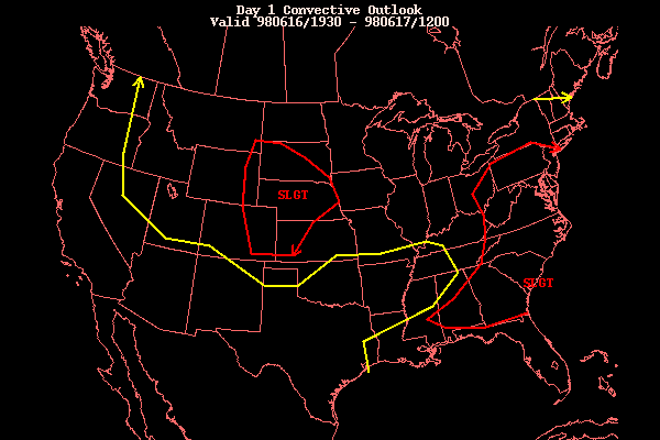
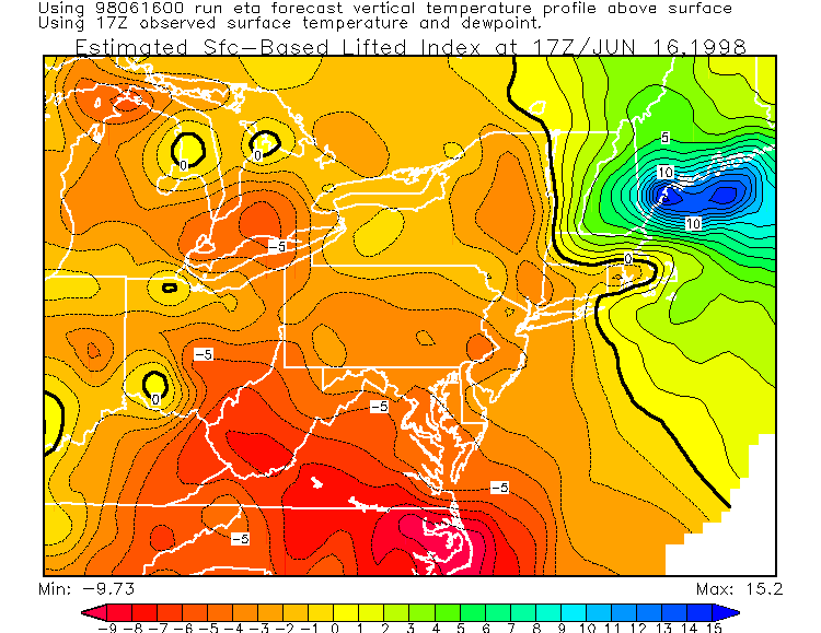
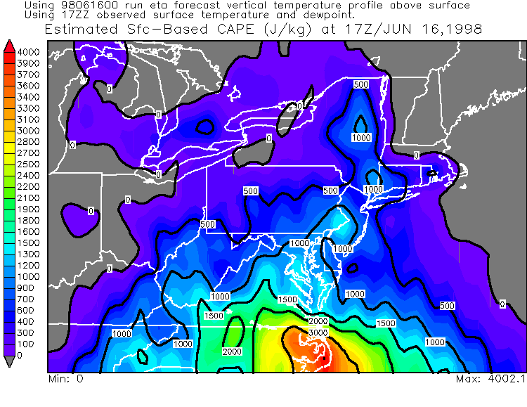
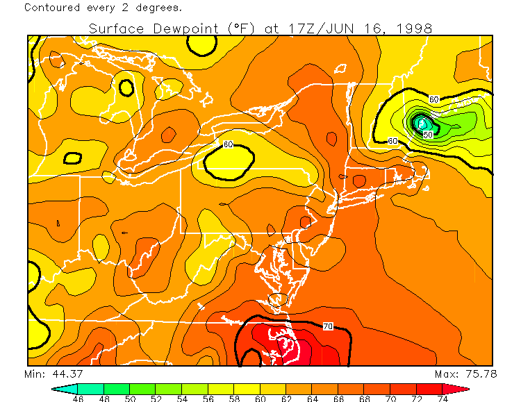
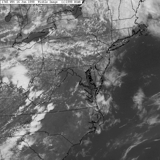
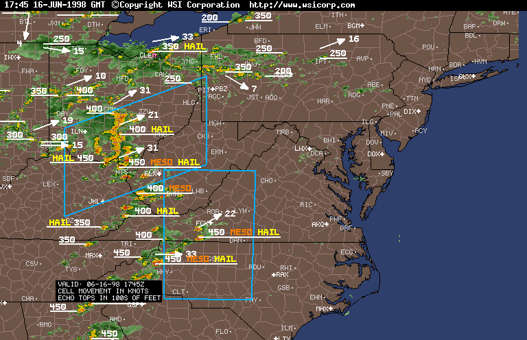
Severe Weather of June 16, 1998Thunderstorms were expected, some severe, this afternoon and evening... but not as intense or as widespread as these. SPC had us in a slight risk, which would be normal for a day like this. You can see the graphic and text. The NWS-CTP issued this thunderstorm potential statement in the late morning. Surrounding offices issued similar statements for their CWA. The morning started off with some sunshine, which helped to quickly destabilize the atmosphere. Instability factors weren't very impressive in the morning, or early afternoon... but as things warmed up, the air got more unstable. You can see how instability slightly increased, by looking at the 17Z (1 pm) LI, CAPE, and dew point ... then comparing with the 21Z (5 pm) LI, CAPE, and dew point. By 1745Z, the visible satellite showed the cumulus clouds developing, in response to surface heating. The regional summary radar map, also at 1745Z, indicated the pop corn type showers and thunderstorms developing across PA. However, as you can see, the most intense storms at the time were over Ohio, West Virginia, and surrounding areas. A closer look at PA, a minute later, gives more detail. As the NWS statement said, very heavy rain with training and slow moving thunderstorms may cause flash flooding. Thus a flash flood watch was issued for southwestern and parts of south-central PA in the mid afternoon hours. Shortly before the flash flood watch was issued, a severe thunderstorm watch was issued by SPC, generally for the southern half of PA. Personally, I would have issued it for all of PA... except the northern tier counties. As the afternoon went on, the pop corn storms ahead of the line, became stronger. At 619 pm, a tornado warning was issued for eastern Lycoming county. On the 2231Z NEXRAD Doppler radar map, you can see, both, the isolated cell in southeastern Lycoming county (note the 66 dbz)... as well as the line of severe thunderstorms in west-central and south-central PA. Severe thunderstorm warnings were also in effect for those storms, with quite a bit of damage being done from thunderstorm winds. Well, as I expected, the storms did move north of the official watch, which is the reason why I thought SPC should have included more of PA in the watch box. However, just before 23Z (7 pm), SPC finally issued a svr tstm watch for most of the rest of PA (better late than never, I guess). The NWS-CTP issued this revised statement. Severe thunderstorm warnings continued to be issued for the central counties. Where I live, northern Northumberland county, there was a strong thunderstorm, which contained extremely heavy rain, hail, and strong wind. In fact, it was some of the heaviest rain I've ever experienced in such a short time. In less than an hour (about 45-50 minutes) 2.48" of rain fell, most of it falling in 40 minutes. Street flooding became a problem, as the rain didn't even have time to wash off the side of the road. I ended up with about an inch of water in my basement, which is 72'x26' in size. (of course during the '96 deadly flooding, there was more than half a foot, but that was a long-term event). During the storm... water was actually coming through the corners of the basement windows - something that has never happen before. The next day, when the water was cleaned and dried up, there was a layer of mud on everything the water touched. Several other basements and garages in the area had water in them too. Besides rain problems here, there was 1/4" (pea size) to occasionally 1/2" (marble size) hail, which was driven by thunderstorm downburst wind gusts up to 45 mph (44.9), that my WX-200 weather station measured at this house. Since the pea size hail was wind driven, it was banging against the north side facing windows. Had it been nickel to quarter size hail, the windows could have easily shattered. The 45 mph tstm winds resulted in a downed tree limb (2" in diameter) a few houses away from mine, lots of twigs and leaves on roads, lawn furniture and trash cans blown around, and even a portable basketball hoop knocked on its side. Wind gusts slightly higher (50-55 mph) occurred in Watsontown, 3 miles south of me. Power lines were downed there, leaving the town in the dark. Lightning was also very frequent, with some strikes hitting quite close to my house. Other parts of PA had wind damage, mainly from severe thunderstorm winds, but the NWS confirmed that several gustnadoes occurred in a few locations. The following paragraphs will provide a description of the wind damage in PA: Fayette, Washington, Greene, Allegheny, Westmoreland, Butler, and Indiana counties: This area, southwest PA, had the most widespread damage. Trees and power lines were downed all over the place as a result of thunderstorm winds. Here are some of the locations that reported trees and/or lines down: Fayette county --Republic
Greene county --Oak Forest
Washington county --Monongahela - one of the downed trees blocked SR 481
Westmoreland county --West Newton
In Stahlstown, a house had its roof torn off by thunderstorm winds. The porch was also ripped off of the house, and several trees were blown down. Downburst thunderstorm winds were likely 70-75 mph. One tornado/gustnado was confirmed in Westmoreland county... between Freeport and Bagdad, or in the vicinity of Garvers Ferry (located in the extreme northern tip of the county). One house received roof damage, and a few dozen trees were downed by this F0 gustnado! Allegheny county --Oakmont
In Wall, 20-30 trees were uprooted, with a few falling onto and damaging homes. Also, thunderstorm winds tipped over the upper boxes on five railroad piggyback cars. Total damage in the area was several thousand dollars. In Glenfield, thunderstorm winds around 55 mph were responsible for causing minor damage to several buildings. Damage totals were tallied in excess of $20,000. In Turtle Creek, strong thunderstorm winds blew the roof off of a house. Butler county --Evans City
Armstrong county --Apollo - a few trees down Indiana county --Blairsville
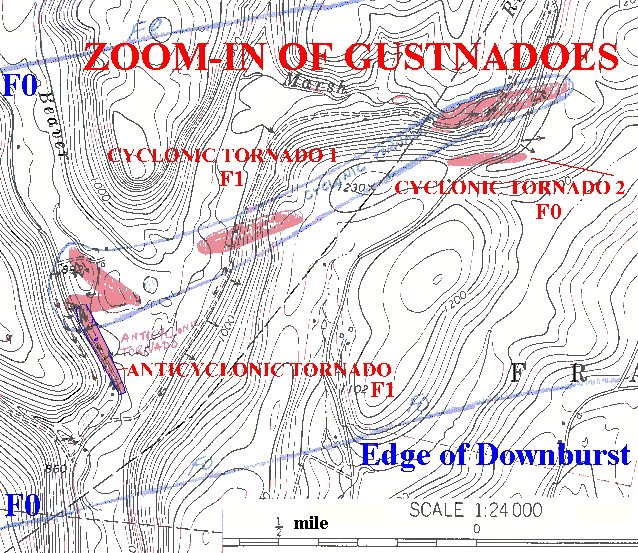
Trees and power lines were downed by severe thunderstorm winds in a several locations across Somerset, Bedford, Blair, and Huntingdon counties. Some towns reporting tree/lines down include Central City (Somerset county), Osterburg, Mench, Hyndman, Stringtown (Bedford county), Homer Gap (Blair county), and Warriors Mark (Huntingdon county). The worst hit in these counties was Bedford county. Two people were injured by the severe thunderstorms. One was hit by a falling tree in Osterburg, and suffered a broken arm. In Hyndman, many trees were downed and mobile homes were damaged. One person was injured at this location as well, and route 96 was closed for a while as trees fell across the road. In Mench, 70-75 mph thunderstorm wind gusts flattened a barn. A farmer narrowly escaped injury. An F1 tornado/gustnado was confirmed in the northern suburbs of Johnstown, specifically the Coopersdale area. It appeared that the strongest winds were quite a few feet above the ground, as is often the case. A few trees were downed/damaged in the area, but most of the damage occurred to roofs. Two high-rise apartment buildings had their roofs ripped off. Another roof was damaged as debris slammed into the building. Clearfield, Centre, Mifflin, and Juniata counties: This area was the least hit. Trees were downed in Beccaria (Clearfield county), and wind gusts as high as 60 mph were recorded at the Penn State Weather Lab in State College as the thunderstorms moved through; some trees were downed in the area. Scattered trees and power lines were blown down across Mifflin county, including in Lewistown. Some trees were also downed in Mc Alisterville... located in Juniata county. In Fulton county, the town of McConnellsburg was particularly hard hit, especially the east side of town. All of the following damage was determined to be done by thunderstorm downburst winds. The majority of the damage appeared to extend from the south side of route 16 to north of SR1006. The first wind damage done was a store sign blown down at a shopping center. In the other damaged areas, numerous trees and powerlines were blown down on residences yards, a couple power poles were snapped, awnings were ripped off of the front and side doors of a house (pieces were thrown many yards), another house had windows broken and a tree branch driven into the roof, and the county fair grounds had trees downed and half of a building roof blown off. Perry, Cumberland, Franklin, Adams, Dauphin, Lebanon, York, and Lancaster counties: In Perry county, several areas received wind damage from thunderstorms. The roof of a home was blown off in Landisburg, with a dozen large trees down on the property. Near Shermans Dale, a mobile home had its roof partially removed, and damage to the porch. A barn nearby sustained major roof damage. Another home in northeast Perry county, Watts Township, also had its roof partially removed. Trees were down across the county, including in Alinda, New Bloomfield, and between Newport & Millerstown. Some roads were blocked. Tree were downed in several areas across Cumberland county, including in Carlisle. A funnel cloud was also sighted a few miles west of Carlisle. Trees and lines were downed in several areas across Franklin and Adams counties... including in Waynesboro. Winds gusted 50-60 mph in Gettysburg. It was much of the same sight in York and Lancaster counties, with trees/lines damaged or downed in several locations. Some houses were damaged in York county as trees fell on them; roads were also blocked. A 61 mph thunderstorm wind gust was recorded near Harrisburg (Dauphin county), and trees were downed. Trees were also downed in Annville and Lebanon (Lebanon county), and tents at the Fort Indiantown Gap National Guard Base were destroyed. In Lycoming county, a very rare phenomenon occurred. One of three gustnadoes that occurred was anticyclonic... unlike most others which are cyclonic. The other two gustnadoes were the normal cyclonic ones. The anticyclonic tornado was rated an F1. F1 rating was also given to the second, and F0 to the third. All three touched down in Penn township toward the end of a 12 mile long downburst... which started just west of Picture Rocks and ended near the Sullivan county line. Between the downburst and gustnadoes, 100-150 trees were uprooted or snapped. At least one home had a window blown in. One resident reported to the NWS survey team that hail as large as half dollars fell right before the tornado. Additional wind damage was noted in extreme southeastern Lycoming county and in extreme northern Columbia county... as a result of a downburst. All damage was to trees, as it is a heavily wooded area, and it was sporadic in nature. The only exception was 2 miles north of Benton along route 487, where a swath of trees were downed. A storm survey of the damage area was completed by meteorologists from the NWS and Greg Forbes, a Professor from Penn State University. A damage map of the entire downburst path was made upon completion, along with a close-up map of the gustnadoes. Snyder, Lycoming, Northumberland, Montour, and Schuylkill counties: Trees and lines were downed in and around Sunbury (Northumberland county), Selinsgrove (Snyder county), and Klingerstown (extreme western Schuylkill county). A falling tree in Klingerstown hit a fire truck, and another tree in Selinsgrove hit a house... with both receiving damage. Winds over 50 mph were estimated around Danville (Montour county). Outside of the tornadic damage in Lycoming county (detailed in above paragraph), thunderstorm winds downed trees in Glen Mawr. Berks, Lehigh, Northampton, and Monroe counties: Several areas in northern Berks county reported downed trees and lines, with some roads blocked. A falling tree damaged a house in Saint Lawrence. Several trees and power lines were then downed by thunderstorm winds in southeastern Lehigh and southwestern Northampton counties, generally in and within a few miles outside of Bethlehem. In Fountain Hill, one of a couple downed trees crushed a car. In Stroudsburg, Monroe county, a severe thunderstorm uprooted a few trees, with downburst winds of 58-62 mph. The NWS offices in State College, Mount Holly, and Pittsburgh issued these LSR's after the storms were over and all reports were in. A National Weather Service storm survey team toured a few locations the next day, to determine the downburst and tornadic damage. This PNS was issued for the Lycoming county tornadoes, and this PNS for the Perry county downburst. Flash flooding became a problem in a couple areas, as expected, especially southern Lycoming county. They experienced about as much rain as I did. The first warning was issued in the mid evening, and the second just before midnight. A camping/trailer park was flooded, with everybody evacuated. Numerous trailers/mobile homes were damaged, mainly skirting torn off the base. Several streets were impassable as water from small streams covered them to a dangerous depth. A mudslide also resulted from the heavy rainfall on route 42 in Franklin township, Lycoming county. In Luzerne county, basements and yards were also flooded. Some basements were completely filled with water... up to the first floor! Go here for a complete listing of all images/text available for this event.
Email: BowEchoCPA@suscom.net |
