
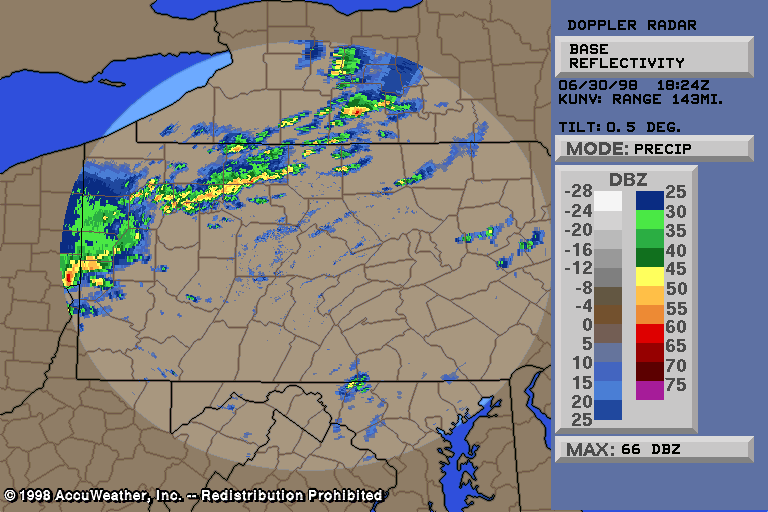
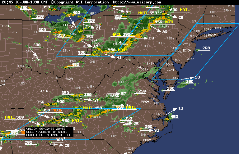
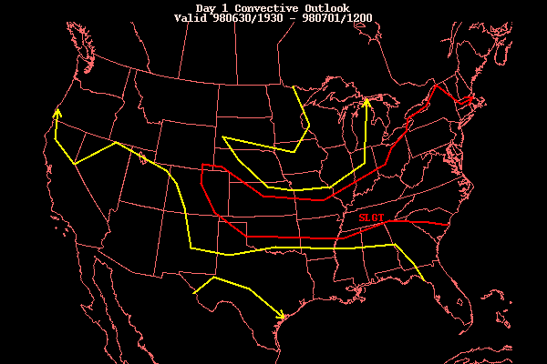
Severe Weather of June 30, 1998Severe weather raked eastern Ohio, southern New York, and much of Pennsylvania during the afternoon and evening hours of June 30, 1998. Isolated areas in Maryland, West Virginia, and Connecticut also experienced severe weather. The storms started to really intensify shortly before 2 pm, in northwest PA and northeast OH. A cold front was draped across OH and northwest PA by mid afternoon. A warm front passed through yesterday, bringing in the unstable airmass. During the afternoon today, LI and CAPE values were enough to support severe thunderstorms, but not tremendously impressive. SPC had us in the usual slight risk, however observed reports after the event were closer to moderate risk criteria. The NWS-CTP (State College office) issued this severe weather outlook, stating the severe weather threat. A severe thunderstorm watch was issued for the western half of PA around 1 pm, and for the rest of PA shortly before 3 pm. Numerous severe thunderstorm warnings were issued for OH, as well as several tornado warnings. The Canton/Akron airport recorded an 84 mph thunderstorm gust. Large air conditioners were ripped off roofs at the airport. Some houses had roofs ripped off, trailers were overturned, and boats at an area lake were flipped upside down. Two houses under construction were flattened. Trees and powerlines were downed in several counties. The storms formed into a line as they moved into PA, resulting in severe thunderstorm warnings being issued for 51 of Pennsylvania's 68 counties. Fairly decent damage occurred in some areas, mostly to trees, but structures were also damaged or destroyed. Several statements were issued for some of the damage reports. Beaver, Butler, Armstrong, Indiana, Washington, and Fayette counties: Dime size hail fell in Farmington, Hopwood (Fayette county), and 2 miles southeast of Shippingport (Beaver county)... while quarter size hail fell in Hookstown (Beaver county), where a couple trees were also blown down. A large tree was blown onto route 68 in Butler, and trees/large limbs were downed in Sarver (Butler county). Two houses and a car were damaged by the falling trees in Sarver, and a car and house was hit in Blairsville (Indiana county). Trees and lines were also downed in several areas across Armstrong and Washington counties. Power was out to portions of Beaver county for over 2 days! Westmoreland county was hit hard, with countless trees and powerlines down across the county. Some trees blocked roads, and fell on houses and cars. A house in Greensburg had its roof torn off, and a barn 10 miles north of Latrobe was destroyed... by thunderstorm winds. In New Kensington, trees and lines were down, power/telephone poles were snapped, and a brick wall collapsed. In Bolivar, there was 65 mph thunderstorm gusts with trees down. In Murrysville, thunderstorm winds caused extensive damage. Numerous trees and power liens were blown down. A new concrete block wall at a car dealership was blown down. At least 10 homes suffered major damage, with countless other homes reporting moderate to minor damage. Minor damage would include broken windows, and stripped siding, gutters, and roof shingles. Maximum winds within this thunderstorm microburst, in the most severely damaged areas, were likely 90-100 mph! Damage in Murrysville alone was about $1 million. In Allegheny county, widespread tree and power line damage occurred also. A roof was ripped off a house in Monroeville by the thunderstorm winds. Nearby houses also suffered damage, and trees were downed. The Pittsburgh International Airport recorded a 62 mph peak wind gust, with minor damage observed. Golf-ball size hail fell in Imperial (trees were downed and a few homes were damaged in Imperial too). Dime size hail fell in Pittsburgh. Trees and lines were down in Verona, along with nickel size hail. In Penn Hills, a 75 foot tree was ripped out of the ground. 50-75 other trees were downed in that area, with many roads blocked. As one person put it: "There's trees down everywhere. You would think a tornado came through here." A car was crushed in Pittsburgh by a falling tree. Numerous trees fell on houses. In the North Hills section of Pittsburgh, a microburst hit, with a width of 1-2 miles and a length of nearly 5 miles. Many trees and powerlines were brought down by the wind, some landing on cars and houses. Many residents reported structural damage to their homes. The hardest hit place was the Larouche College area, where significant window and roof damage occurred. The roof of a McCandless convent was ripped off, causing injury to three nuns. In total, 10 injuries were reported with this severe thunderstorm across the damaged area. Just north of Pittsburgh, one township had so many trees down that it took 3 weeks for them to be completely cleared!! Thousands of people didn't have power for days! Damage was just so widespread and locally quite significant. This made the damage total for Allegheny county alone very high -- more than $40 million!! Warren, Mckean, Cameron, and Tioga counties: Marginally severe thunderstorms moved across this area... dropping large hail and downing trees/lines. Dime size hail fell in Sheffield, while nickel size hail fell in Bradford and Rew. Trees were blown down by thunderstorm winds onto route 6 two miles east of Kane, and in Emporium, Sinnamahoning, and Wellsboro. There was also trees down in other remote areas, mainly across Tioga county. Clearfield, Cambria, and Blair counties: Thunderstorm winds blew down trees in a few areas across these counties... including north of Du Bois (Clearfield county), throughout the city of Altoona, and in Ebensburg (Cambria county)... where a tree fell on a car. In west central Cambria county, a gustnado of F0 strength spun up within a larger area of downburst damage. The tornado/gustnado started in Vintondale and traveled east into the town of Nanty Glo... a length of about 5 miles. The width of the tornado was no more than 150 feet, while the downburst thunderstorm winds were wider than 2,000 feet at times. Numerous trees were downed along the damage path, with at least one house significantly damaged in Vintondale from a falling tree. A man in the same general area told of watching his patio grill be lifted up and spun over the roof of his house. In northern Somerset county, a downburst more than 20 miles long struck. It
started atop
Laurel Mountain (in Forbes State Forest), along the Westmoreland/Somerset
county line, and
tracked east-southeast for roughly 22 miles. It followed a path very close to
route 30... with
a width of up to 2 miles for a brief time. Some towns that were in the path of
this downburst
include Gray, Ralphton, Stoystown, Lambertsville, and Buckstown. This was a
downburst of
minimal strength... with winds often below 58 mph (50-55 mph). However, winds
occasionally
were noted just above 60 mph. Damage along the path was mainly to trees and
power lines,
although very minor structural damage may have gone unreported. Many trees had
limbs ripped
out of them, with some trees being snapped or uprooted. Toward the end of the
downburst path,
in Buckstown, a gustnado spun up. As is almost always the case, the gustnado's
path length and
width were much smaller than the downburst itself. Length was about a quarter
mile, and width
of the gustnado was around 200 feet. The downburst at that location was just
under a mile wide.
Intensity rating of the gustnado was on the lower end of F1. Approximately 100
trees were
either snapped or uprooted by this small gustnado/tornado.
Clinton, Centre, Huntingdon, Bedford, and Fulton counties: Thunderstorm winds knocked over trees/lines in or near Renovo, Mackeyville (Clinton county), Philipsburg (Centre county), Marklesburg (Huntingdon county), Wells Tannery (Fulton county), and Bedford (Bedford county). Bedford county had the most widespread damage, with many trees down in the town of Bedford and in other areas across the county. A trailer belonging to the National Guard was picked up and thrown 30 feet by a strong thunderstorm wind gust, landing upside down on a vehicle. People took shelter inside the nearby WalMart store... reducing the injury count to zero, thankfully. Winds with this event were not strong enough to damage the Walmart store. Franklin, Juniata, Mifflin, Perry, Cumberland, and Dauphin counties: At Middletown, Dauphin county, a 60 mph thunderstorm gust was recorded. The same went in Franklin county, in the Greencastle area, where the wind gust knocked over a fence. Trees and/or power lines were downed by thunderstorm winds in the following locations (county name given in parenthesis): Mifflintown (Juniata), Lewistown (Mifflin), Landisburg, Shermansdale (Perry), Camp Hill, Shiremanstown (Cumberland), Hershey, and Elizabethville (Dauphin). There were also several areas in the above counties that had some trees down in remote locations... not mentioned here. In addition, the severe thunderstorms blew over a large sale tent at the mall in Camp Hill, and roads were blocked from fallen trees in Hershey. In Lycoming county, trees and power lines were downed in a few areas across the county. Two downbursts were confirmed in Lycoming county, one near Cammal and the other near Jersey Mills. The Cammel downburst had wind speeds of no more than 60 mph, but were as low as 40 mph at times. 3 trees were uprooted, one crushing a mobile home. No one was home. More than a dozen other large pine trees were snapped. Some other minor tree damage occurred outside of this swath, with winds less than 50 mph. The second downburst, which occurred near Jersey Mills, had winds of 60-70 mph. More than 1 dozen trees were uprooted when peak wind gusts occurred. Other tree damage was seen in the general area, from lesser winds. At least one major road was closed for an hour, while fallen trees were cleaned-up. The thunderstorm winds also downed trees and power lines in other areas across Lycoming county, but no significant damage was noted. Nevertheless, two people were injured outside of Jersey Shore when a strong thunderstorm wind gust downed a tree on the pickup truck they were in. Winds gusted to 60 mph at the EMA office in Montoursville. Union, Snyder, Northumberland, Columbia, and Schuylkill counties: Trees were brought down by thunderstorm winds in Lewisburg (Union county), Milton (Northumberland county), Middleburg (Snyder county), Danville (Montour county), Bloomsburg, Berwick (Columbia county), and Mahanoy City (Schuylkill county). Northumberland and Montour counties had trees down in several areas, besides the towns mentioned above. In Bloomsburg, a billboard was also blown over. Hail as large as nickels fell in Mahanoy City. Bradford, Sullivan, Wyoming, Susquehanna, Luzerne, and Lackawanna counties: A few trees and lines were downed by thunderstorm winds in/near Athens, Canton (Bradford county), Silver Lake, Clifford (Susquehanna county), Nicholson (Wyoming county). More widespread tree and power line damage occurred across the southern half of Luzerne county. Numerous to many trees were down in some areas, with a couple houses damaged in Salem township, and store windows blown out in Conyngham. Conyngham was hardest hit, with many of the store front winds shattered, and several buildings damaged by falling trees and other flying debris. Dollar estimates were in the thousands in that town. Numerous areas were without power, with at least one pole downed in the Nanticoke area. Dime size hail fell in Laporte (Sullivan county), and Covington township (Lackawanna county)... where some trees were also blown over onto Interstate 380. Wayne, Pike, and Monroe counties: Fairly widespread tree and power line damage occurred across parts of Wayne and Pike counties, especially within a few miles north and south of route 6. Many trees were downed in these areas, with some power poles also toppled. Most locations lost electrical service. Numerous roads were blocked for a few hours as debris was cleaned up. In Monroe county, dime size hail, along Interstate 380 by exit 7. Scattered downed trees were reported across the county, with the most (being less than a dozen) probably in Chestnut township. Damage was not nearly as significant in Monroe county as it was in Wayne/Pike counties. Berks, Carbon, Northampton, and Lehigh counties: Scattered downed trees/limbs and power lines were reported across these counties, with a few roads blocked for a short time in a couple areas. A few trees and power lines were downed in Kidder township (Carbon county). A tree fell on a house in Colebrookdale township (Berks county), causing damage. In Allentown (Lehigh county), trees and lines were blown down. One tree crushed a pickup truck. Thunderstorm winds were also strong enough to overturn a tractor trailer on I-78 in Allentown. Thunderstorm winds to 60 mph downed trees onto and blocked route 22 in Bethlehem (Northampton county). One hit a automobile, demolishing it. A bit north of here, in the Nazareth area, trees and power lines were downed and a shed was blown off its foundation by 60 mph thunderstorm winds. York, Lancaster, and Lebanon counties: Trees were downed by thunderstorm winds in Foustown, parts of Fairview township (York county), in a number of areas in Lancaster county, and across Lebanon county. Lebanon county was probably the hardest hit, with dozens of reports fo trees and power lines down. Few areas escaped downed limbs or trees. Numerous roads were blocked. Yet the most amazing story came from Manheim township in Lancaster county. A woman went outside during a severe thunderstorm to try and pickup her trash cans that were blowing away with the winds. When she realized that she should not be outside, as winds started to get very strong (over 45 mph), she tried to run back inside her house. It was too late however -- trees and limbs came crashing down around her. Her husband found her dazed and covered by branches. The main trunk and limbs, 20 feet long, surrounded her in a "V" shape, missing her body by inches! She was covered in the smaller and more flexible branches, walking away uninjured! Now that is one lucky woman if I have anything to say about it. Remember, do not stay in the open during severe thunderstorms (or for that matter, even non-severe thunderstorms, as lightning is the 2nd biggest killer)! However, when talking about severe thunderstorms, damaging winds kill dozens a year! All to often in this country, people are hit and seriously injured or killed by falling/flying trees or limbs. It's just amazing how she was missed by a few inches... Chester, Bucks, Montgomery, Delaware, and Philadelphia counties: Several large trees and power lines were blown down in Springfield township (Bucks county), with some homes damaged as trees fell upon them. Langhorne, Bristol, and Middletown townships also reported scattered downed trees and power lines. Even though it was scattered, a man in Bristol township was still injured when thunderstorm winds blew down a tree onto the car which he was in. In Langhorne and Middletown townships, fallen trees damaged a fence, destroyed a shed, and ripped portions of siding from a house. A few trees were downed in Philadelphia county, with at least one road blocked for a short time until crews were able to cut up and remove the fallen tree. Some more trees and power lines were blown down in Delaware county, with several roads blocked. A few houses were hit and damaged in Radnor and Upper Darby townships as the trees fell by thunderstorm winds as high as 60 mph. In Chester county, damage was mainly across northern sections of the county. Numerous roads were blocked by downed trees and lines, and at least one house was damaged by a falling tree in Downington. Several people had to be rescued from an elevator in Coatesville when power was lost. Numerous trees and power lines were blown down across Montgomery county as the line of severe thunderstorms moved through. In Whitpain township, a tree was snapped by the damaging thunderstorm winds 20 feet above the ground. Its limbs landed on an occupied vehicle and broke a window, injuring the person inside. Several trees were uprooted at the country club, also in Whitpain township. Two more persons were injured as a large tree limb fell onto their Blazer and trapped them inside. In Horsham, another person was trapped inside their vehicle as downed tree limbs and power lines fell upon the automobile. Fortunately, unlike the other three persons, this one escaped injury. Numerous houses and vehicles were hit and damaged by falling trees in Abington, Bryn Athyn, Horsham, Perkiomenville, and Upper Dublin townships. Travel on the Schuylkill expressway was slowed because of downed tree limbs. Numerous streets across the county were closed because of downed trees and lines. There was a few streets still closed the next day in Lower Merion township. Flash flood warnings were issued for Beaver, Washington, Fayette, and Greene counties. Houses were flooded in Claysville, Washington county. No flash flood warnings were issued for eastern PA, but the normally flood prone areas were flooded again. In Scranton, several streets were under 1 foot of water, with other roads under a few inches. A few foolish drivers tried to make it through the water, but found themselves stuck, and needed to be rescued. After the storms left PA, they entered the southern half of NY, northern NJ, CT and MA. Although the line of thunderstorm fell apart, clusters of severe thunderstorms continued. In southern NY, 2 children were injured by lightning, and four people were injured when their house trailer was rolled over by thunderstorm winds. In Queens county, NY, three girls were injured by falling tree limbs. One was seriously injured, and needed surgery. Dime size hail broke numerous windows in Bronx. In Syosset, Nassau county, strong thunderstorm winds ripped the roof off a house, and downed trees. Just like in PA, trees and power lines were downed in numerous locations. Substantial hail fell in New England too, which is somewhat unusual for that area. Several reports of 1" hail was received by the NWS, and there was even a report of golfball to baseball size hail in Washington county RI!! That is very rare for Rhode Island. The following are select NEXRAD radar images from this severe weather outbreak. Click on one to see the actual radar picture:
Go here for a complete listing of all images/text available for this event.Email: BowEchoCPA@suscom.net |


