
It may seem to you that air has no mass. However, air consists of atoms and molecules, which have mass. So air must have mass. Because air has mass, it also has other properties, including density and pressure.
The amount of mass in a given volume of air is its density. You can calculate density by dividing mass by volume. Density= Mass/Volume. If there are more molecules in a given volume of air, the density is greater. If there are fewer molecules, the density decreases.
The force pushing o an area or surface is known as pressure. A denser substance has more mass per unit than a less dense one. So denser air exerts more pressure than less dense air.
Air pressure is the result of a column of air pushing down on an area. The weight of the column of air above you if only slightly less than the weight of a large school bus! So why doesn't the air pressure crush you? It is because the molecules push in every direction, not just down. Thus, the air pressure pushing down on you is balenced by the air pressure pushing up on you.
The air pressure at the top of Mt. Everest [which is more than 5 miles above sea level] is less than half the air pressure at sea level. Altitude, or elevation, is the distance above sea level. Air pressure decreases as altitude increases. As air pressure decreases, so does density.
Imagine a stack of ten books, Which book has more weight on it, the top or bottom book? The book on the top has no other books pushing down on it. The bottom book has nine other books pushing down on it. Thus, the bottom book has the most weight on it.
Air at sea level is like the bottom book. Recall that air pressure is the weight of the column of air pushing down on somethin. Sea level air has the weight of the whole atmosphere pushing down on it. So air pressure is greatest at sea level. Air near the top of the atmosphere is like the top book. There, the air has less weight pushing on it, and thus has lower air pressure.
If you were at the top of Mt. McKinley and tried to run, you would get out of breath quickly. Why would you have difficulty breathing at high altitudes?
As you go up through the atmosphere, the air pressure decreases. As air pressure decreases, the density of the air decreases. So density decreases as altitude decreases.
Wheather air is at sea level or at six kilometers above sea level, it still contains the same percentage of oxygen: 21%. However, since the air is less dense at a high altitude, there are fewer oxygen molecules for you to breathe in each unit cubed of air than at sea level. You take in less oxygen with each breathe. This is why you would get out of breathe quickly.
Imagine taking a trip in a hot-air balloon. You begin at sea level-0 kilometers altitude.
The pilot turns up the engine, and you rise higher and higher. Earth gets farther and farther away. The balloon is soon at an altitude of 3 kilometers, and you realise that it's getting colder. You continue rising and the air keeps getting colder and colder. At 6 kilometers, it gets hard to breathe. The air's getting less dense. It's time to go down.
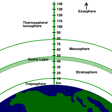
What if you kept going? As you rose farther through the atmosphere, the air pressure and temperature would change dramatically. The four main layers of the atmosphere are classified by the changes in temperature. The layers are the troposphere, stratosphere, mesosphere, and thermosphere.
You live in the lowest layer of the atmosphere, the troposphere. Conditions in the troposphere are more variable than in the other layers. This layer is where weather occurs.
Though hot-air balloons can't travel very high into the atmosphere, other types of balloons can. In order to measure weather conditions, scientists launch weather balloons that carry special instruments into the atmosphere. They aren't entirely filled before they're launched. Recall that air pressure decreases as you go up in the atmosphere. Leaving it only partially inflated gives the gases inside time to expand as air pressure decreases
The depth of the troposphere varies depending on where you are. Above the equator it is more than 16 kilometers, but at the poles, it is less than 9 kilometers high. Even though it's the smallest layer of the atmosphere, it contains most of the mass of the atmosphere.
As altitude increases in the troposphere, the temperature decreases. On average, for every 1-kilometer increase in altitude the air gets about 6.5 degrees Celcius cooler. At the top of the troposphere, the temperature stops decreasing and stays constant at approximately -60 degrees Celcius. Water here forms thin, feathery clouds of ice.
The stratosphere extends from the top of the troposphere to approximately 50 kilometers above the surface of Earth.
The lower stratospher is about -60 degrees Celcius. You may be surprised to learn that the upper stratosphere is warmer than the lower stratosphere! Why might this be? The upper stratosphere contains ozone, a three-atom form of oxygen. When the ozone absorbs energy from the sun, the energy's converted into heat, thus warming the air.
As a weather balloon rises through the stratosphere, the air pressure outside the balloon keeps decreasing. The volume of the balloon increases. The balloon soon bursts, and the instrument package falls back to Earth.
Above the stratosphere, a drop in temperature marks the beginning of the mesosphere. The mesosphere is the middle layer of the atmosphere. It begins 50 kilometers above Earth, and ends at 80 kilometers. The outer part of the mesosphere is the coldest part of the atmosphere, at about -90 degrees Celcius.
If you watch a shooting star streak across the sky, you're seeing a meteoroid burn up as it enters the mesosphere. This layer protects earth's surface from being hit by most meteoroids, which are chunks of stone and metal from space. What you see as a shooting star, or meteor, is the trail of hot, glowing, gases the burning meteoriod leaves behind.
Near the top of the atmosphere, the air is very thin. The air 80 kilometers above earth's surface is only about 0.001% as dense as the air at sea level. It's as though you took a cubic meter of air at sea level and expanded it into 100,000 cubic meters at the top of the mesosphere. The outermost layer of the atmosphere, the thermosphere, extends from 80 kilometers above Earth's surface outward into space. It has no definite outer limit. The atmosphere does not end suddenly at the outer edge of the thermosphere. Gas atoms and molecules there are so far apart that the air blends in gradually with outer space.
Even though the air in the thermosphere is thin, it is very hot, up to 1,800 degrees Celcius! The temperature in the thermosphere is accually higher than the temperature in a furnace used to make steel! But why is the thermosphere so hot? Energy coming from the sun strikes the thermosphere first, so Nitrogen and Oxygen molecules convert energy from the sun into heat.
Despit the high temperature, however, you wouldn't feel warm in the thermosphere. An ordinary thermometer would show the temperature to be below 0 degrees Celcius! But why is that? Temperature is the average amount of energy of motion of each molecule of a substance. The gas molecules in the thermosphere move very rapidly, so the temperature is very high. However, the molecules are spaced far apart in the thin air. So, there are not enough of them to collide with you or the thermometer to warm it. So, an ordinary thermometer would not detect very much of the energy.
The thermosphere is divided into two layers. The lower layer of the thermosphere, the ionosphere, starts at 80 kilometers above the surface and ends at 550 kilometers. Energy from the sun causes molecules to become electrically charged particles called ions. Radio waves bounce off ions in the ionosphere and back to Earth.
The brilliant light display of the aurora borialis occurs in the ionosphere. The aurora borialis is caused by particles from the sun that enter the ionosphere near the poles. They hit oxygen atoms as well as nitrogen and cause them to glow.
The exosphere is the outer layer of the thermosphere. It extends from 550 kilometers outward for thousands of kilometers. When you make a long-distance phone call or watch TV, the signal probably traveled to a sattelite orbiting up in the exosphere, then back to you. Sattelites are used to see weather on the Earth and carry telescopes to look into space.
Have you ever noticed how on a summer morning it's cool, but it gets warmer as the sun rises? Then as the sun lowers, it gets cool again. As you will soon see, heat is a major factor in the weather. The transfer and movement of heat causes temperature changes, wind, and rain.
Most of the energy in the atmosphere is from the sun. This energy gets to earth in electromagnetic waves, a kind of energy able to travel throgh space. Electromagnetic waves are classified according to their distance between waves, or wavelength. The direct transfer of energy by electromgnetic waves is called radiation.
Most enegy from the sun comes to Earth in visable light, infared radiation, and a small bit of ultraviotet radiation. Visable light is a mixture of the colors in the rainbow: Red, orange, yellow, green, blue, and violet. Scientists have discovered that indigo isn't a color of the rainbow. These different colors are the results of different wavelengths of visable light. Red and orange have the longest wavelengths, while blue and violet have the shortest.
Infared radiation is a type of energy with wavelengths longer than redlight. Although you can't see it, you can feel it as heat. Heat lamps that keep food warm give off red light and infared radiation. The sun gives off ultraviotet radiation as well. This radiation has wavelengths shorter than violet light. This radiation causes sunburns and skin cancer. It can also cause eye damage.
Before the sun's radiation can reach Earth it must go through the atmosphere. Some energy from the sun is absorbed by the atmosphere. Water vapor and Carbon Dioxide absorb some infared radiation. The ozone absorbs ultraviolet. Clouds, dust, and other gases also absorb some.
Some rays are reflected. Clouds are like mirrors, reflecting solar energy back to space. Dust and molecules, reflect light in every direction.
This type of reflection is called scattering. When you look at the sky, you are seeing the light that's been scattered. Molecules scatter short wavelengths of visible light, like blue and violet, more than long wavelengths, like red and orange. Scattered light, for that reason, is bluer than regular sunlight, which is why the sky looks blue.
When the sun is rising or setting, light from the sun passes through a greater thickness of atmosphere than when the sun is higher. More light from the blue end is removed by scattering before it hits your eyes. The light left has mostly red and orange light. The sun, therefore, looks red and the clouds around it are colorful.
Some of the sun's energy is reflected back after it hits Earth's surface. Some energy is, however, absorbed by land and water, which turns it into heat.
When Earth's surface is heated, it radiates some energy back to the atmosphere as infared radiation. This infared radiation can't go all the way back to space. Water vapor absorbs it, instead, as well as Carbon Dioxide, Methane, and other gases. The energy from the absorbed radiation then heats the air's gases. The gases form something like a blanket, around Earth which holds the heat in. This is called th greenhouse effect.
The greenhouse effect is natural and keeps temperatures comfortable for most things. Human activities over the last few hundred years have put a large amount of Carbon Dioxide into the air. This may be amplifying the greenhouse effect. You will learn more about this later.
You recall that the sun's energy is absorbed by Earth. Some is then transfered to the atmosphere as heat. The heat then moves through the atmosphere. But how does it move?
Gases are made up of molecules that are always moving. The faster they move, the more energy they have. The total amount of energy of motion in them is thermal energy. However, temperature is the average amount of energy of a substance. That means that temperature is a measure of how hot or cold something is.
The energy transfered from the hotter to the colder object is called heat. Heat is transfered in three ways: radiation, conduction, and convection.
The warmth of the sun on your face is energy coming directly from the sun as radiation. Recall that radiation is the transfer of heat through electromagnetic waves. The heat from the sun, a fire, or a radiator travel to you through infared radiation. You can't see it, but you can feel it as heat.
When you walk barefoot on hot sand, your feet feel hot because the heat from the sand goes directly into your feet. When a fast molecule hits a slower molecule, it transfers some of its energy to it. The direct transfer of heat is called conduction. The molecules that gain energy also transfer it to other molecules. When you walk on hot sand, the fast sand molecules transfer to the slow moving molecules in your feet. < br />
The closer together the molecules are, the more effectively they conduct. Conduction works well in most solids, like metals, but not as well in liquids and gases.
Have you ever wondered how you can heat your boots over a hot-air vent, when the furnace is in another room? The answer is that air from the furnace carries the heat to your boots. In liquids and gases, molecules can move from place to place. As they move, they take the heat with them. The transfer of heat by the movement of a liquid or gas is called convection.
All of these forms of heat transfer work together to heat the troposphere. When Earth absorbs solar energy during the day, the land becomes warmer than the air. The air near the surface is heated by radiation and conduction of the heat on the surface. But, heat isn't easily conducted from one air molecule to the other. Only a few meters of air are warmed by conduction. Thus, air is warmer near the ground.
Convection heats most of the troposphere. When air near the ground is heated, molecules have more energy. Because they do, they move faster. As they move, they bump into each other and move farther apart. The air gets less dense. Denser air sinks, forcing the warmer air to rise.
The upward motion of warm air and downward motion of cold air form convection currents. Convection currents move heat in the troposphere.
The highest point in the NE US is at 1,917 meters-Mt. Washington. Sometimes winds here are so fast that hikers can't get to the top safely. The greatest wind speed ever was recorded here, at 370 kph. What could cause this?
Air can move from place to place, and does because of differences in pressure. Air tends to move from an area of high pressure to an area of low pressure. A wind is the horizontal movement of air from one place tot he other. All winds are caused by differences in air pressure.
Most differences in air pressure are caused by unequal heating. As you've learned, convection currents form when an area is heated by the sun. Air over the heated surface expands and becomes less dense. Its air pressure, thus, decreases as well. If an area nearby iisn't heated quite as much, the air above the less-heated area will move to the heated area. This process forces the warm air to rise.
Even though there's no wind inland, you still may be able to fly a kite on a hot beach, because a small breeze is blowing. That breeze would be a good example of a local wind. Local winds are winds that blow over short distances and are caused by unequal heating of Earth's surface OVER A SHORT AREA. Local winds cannot form if other winds are blowing from farther away.
Unequal heating usually occurs on land next to a large body of water. It takes less energy to heat land, so as the sun heats the Earth during the day, the land gets hotter than the water. The air over the land heats up more and decreases in density. The cool air blows inland from the water and goes under the warmer air. A wind blowing from an ocean or lake is known as a sea breeze or lake breeze.
At night, this is reversed. Land cools faster than water, so air over land becomes cooler. The air over water is warmer, so it rises, and the cool air over the land takes its place. This reverse sea breeze is, surprisingly enough, called a land breeze.
There are some winds that blow steadily from specific directions over long distances. They're called global winds. They are also created from unequal heating of the Earth. In the middle of the day near the equator, the sun is almost directly overhead. These direct rays heat Earth's surface intensely. Near the poles, the same amount of sunlight is spread out over a larger area, so it heats that area less. As a result, the poles are cooler than the equator.
These differences in temperature produce gigantic convection currents. Warm air rises at the equator, and cold air sinks at the poles. Thus, air pressure is lower at the equator and greater near the poles. This causes winds at Earth's surface to blow from the poles to the equator. Higher up, air from the equator blows to the poles.
Because of the Earth's rotation, global winds do not move straight, instead they are curved. This is called the Coriolis effect. In the northern hemisphere, all global winds curve to the right (from where they are). In the southern hemisphere, they curve to the left.
The Coriolis effect and other factors combine to produce a pattern of wind belts and calm areas around Earth. The major global wind belts are the trade winds, prevailing westerlies, and polar easterlies.
The sun heats the surface strongly near the equator, making warm air rise steadily, which creates an area of low pressure. Cool air does move into the area, but it is warmed quickly and rises. There is not much horizontal motion, so winds near the equator are weak. The regions here are called the doldrums.
Warm air that rises at the equator moves both north and south. At about 30 degrees north and south latitude, the air stops moving north and sinks. Here, another belt of calm air forms. Hundreds of years ago, sailors got stuck in these waters and ran out of food for their horses. They had to throw their horses overboard. Because of this, 30 degrees north and south are called the horse latitudes.
When the cold air over the horse latitudes sinks, it crreates a region of high pressure. This causes surface winds to blow both towards and away from the equator. These winds are turned by the Coriolis effect. Thus, winds between the 30 degrees north and the equator blow from the northeast. Winds between 30 degrees south and the equator blow from the southeast. These are called trade winds. For hundreds of years, sailors relied on them to carry cargoes from Europe to middle America.
In the mid-latitudes, winds blowing towards the poles are turned east by the Coriolis effect. Because they blow from the west, they are named the prevailing westerlies. They generally blow from the southwest between 30 and 60 degrees north, and northwest between 30 and 60 degrees south. The prevailing westerlies play an important part in US weather.
Cold air near the poles sinks and flows towards the equator. The Coriolis effect shifts the direction of the winds to the west, creating winds called the polar easterlies. These winds meet the prevailing westerlies at about 60 degrees north and south, along a region called the polar front. The mixing of the warm and cold air has a major effect on the weather in the US.
About 10 kilometers above Earth's surface are bands of high-speed winds called jet streams. These are hundreds of kilometers wide but only a few kilometers deep. Jet streams blow from east to west at speeds of 2-400 kph. As they travel around Earth, they wander north and south along a wavy path.
Jet streams aid airplanes when traveling east. Pilots can save time and fuel by traveling east in a jet stream. However, they are slowed down when traveling west in a jet stream.
As you know, clouds come in different shapes. Meteorologists classify clouds into three main types: cumulus, stratus, and cirrus. Clouds are also classified by their altitudes. Each type of cloud is associated with a type of precipitation.
Clouds that look like fluffy, rounded piles of cotton are called cumulus clouds. Cumulus clouds form less than 2 kilometers above the ground, but may grow in size and height until they extend upward to as much as 18 kilometers. Cumulus clouds usually mean fair weather. Towering clouds with flat tops, called cumulonimbus clouds, often produce thunderstorms.
Clouds that form in flat layers are called stratus clouds. Stratus clouds usually cover most of the sky. As they thicken, they may produce drizzle, rain, or snow. They are then called nimbostratus clouds.
Wispy, feathery clouds are called cirrus clouds. Cirrus clouds only form at high levels, about 6 kilometers, where temperatures are very low. As a result, cirrus clouds are made mostly of ice crystals
Cirrus clouds with feathery "hooked" ends are sometimes refered to as mare's tails. Cirrocumulus clouds, which look like rows of cotton balls, often indicate that a storm is on its way.
Part of a cloud's name may be based on its height. The name of clouds that form between 2 and 6 kilometers above Earth have the prefix alto-, which means high. The two main types of these clouds are altocumulus and altostratus.
Clouds that form at or near the ground are called fog. Fog often forms when the ground cools at night after a warm, humid day. The ground cools the air just above the ground to the air's dew point. The next day, the heat of the sun "burns" the fog off as its water droplets evaporate.
In warm parts of the world, precipitation is almost always rain or drizzle. In colder regions, precipitation mmay fall as snow or ice. Common types of precipitation are rain, sleet, freezing rain, hail, and snow.

The most common type of precipitation is rain. Drops of water are called rain if they're at least 0.5 mm in diameter. Precipitation made up of smaller drops of water is called mist or drizzle. Mist or drizzle usually fall from nimbostratus clouds.
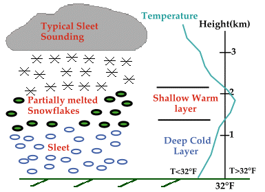
Sometimes raindrops fall through a layer of air below 0 degrees Celcius, the freezing point of water. As they fall, the raindrops freeze into solid ice particles. Ice particles smaller than 5 mm in diameter are called sleet.
At other times raindrops falling through cold air near the ground do not freeze in the air, but instead freeze when they touch a cold surface. This is called freezing rain. In an ice storm, a smooth, thick layer of ice builds up on every surface. The weight of the ice may break tree branches onto power lines, causing power failure. Freezing rain and sleet can make sidewalks and roads slippery and dangerous.
Round pellets of ice larger than 5 mm in diameter are called hailstones. Hail forms only in cumulonimbus clouds during thunderstorms. A hailstone starts as an ice pellet in a cold region of a cloud. Strong updreafts in the cloud carry the hailstone up and down through the cold region several times. Each time it goes through the cold region, a new layer of ice forms. Eventually, the hailstone is heavy enough to fall to the ground. If you cut one in half, you often can see shells of ice, like the layers of an onion. Because hailstones can grow quite large, they can cause great damage to cars, crops, and buildings.

Often, water vapor in a cloud is directly converted ice crystals called snowflakes. Snowflakes have an infinite number of shapes, patterns, and sizes, all with 6 sides. Snowflakes usually join together in clumps of snow in wich the crystals are difficult to see.
Page 1, Page 2
