
undefined
< US 170 | Home | US 11 and Branches > |
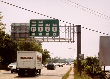
| ROUTE LOG VA STATE LINE: 0 - 0 US 58 WB: 9 - 9 US 58 EB, BEGIN US 58 Bus: 5 - 14 US 58 Bus EB, VA 47: 2 - 16 VA 138: 3 - 19 I-85 (exit 15): 0.25 - 19.25 BR-ME LINE: 3 - 22.25 VA 46: 11 - 33.25 I-85 (exit 28): 1 - 34.25 VA 136: 0.75 - 35 DI-BR LINE: 10 - 45 VA 40: 3 - 48 US 460 Bus WB: 19 - 67 VA 142: 1 - 68 I-85 (exit 63), US 460: 0.25 - 68.25 VA 226: 1 - 69.25 VA 319, VA 357: 0.25 - 69.5 PET-DI LINE: 0 - 69.5 US 301 ALT SB: 2 - 71.5 US 460 Bus EB: 0.25 - 71.75 US 301 SB, US 301 ALT END, VA 36 EB: 0.25 - 72 VA 36 WB: 0.25 - 72.25 COL-PET LINE: 0.25 - 72.5 VA 144 SB: 1.5 - 74 CH-COL LINE: 1.75 - 75.75 VA 144 NB: 0.25 - 76 VA 366: 2.5 - 78.5 VA 10: 0.5 - 79 VA 288: 1.5 - 80.5 VA 145: 2 - 82.5 VA 150: 2.5 - 85 RIC-CH LINE: 1.5 - 86.5 VA 161: 0.5 - 87 US 360: 4 - 91 US 60: 0.25 - 91.25 VA 195: 1.5 - 92.75 VA 147: 0.25 - 93 US 250: 0.5 - 93.5 VA 33: 0.25 - 93.75 I-64, I-95 (exit 76): 0.25 - 94 VA 197: 2 - 96 US 301 NB, VA 2: 1 - 97 HR-RIC LINE: 0 - 97 I-95 (exit 81): 0.5 - 97.5 VA 161: 1 - 98.5 VA 73: 1.5 - 100 I-295 (exit 43): 1.5 - 101.5 HN-HR LINE: 0.5 - 102 VA 54: 5 - 107 VA 30: 6 - 113 CA-HN LINE: 3 - 116 VA 207: 3 - 119 SP-CA LINE: 13 - 132 US 17 SB: 9 - 141 I-95 (exit 126), US 17 NB: 0.5 - 141.5 US 1 Bus, VA 208: 1 - 142.5 FRE-SP LINE: 1 - 143.5 VA 3: 1.5 - 145 US 1 Bus, US 17 Bus SB: 1.75 - 146.75 ST-FRE LINE: 0.25 - 147 US 17 Bus NB, VA 212: 0.5 - 147.5 PW-ST LINE: 17.5 - 165 VA 234: 4 - 169 VA 123: 8 - 177 FX-PW LINE: 0.5 - 177.5 I-95 (exit 161): 0.5 - 178 VA 242: 1 - 179 Va 235: 5.5 - 184.5 VA 235: 2.75 - 187.25 VA 241: 3 - 190.25 I-95 (exit 176), I-495: 1.5 - 191.75 ALX-FX LINE: 0 - 191.75 VA 236: 1 - 192.75 VA 7: 0.25 - 193 AR-ALX LINE: 2 - 195 VA 120: 0.75 - 195.75 VA 233: 0.25 - 196 I-395 SB (exit 9), VA 110: 0.75 - 196.75 GW PKWY: 0.25 - 197 DC LINE: 0.25 - 197.25 |
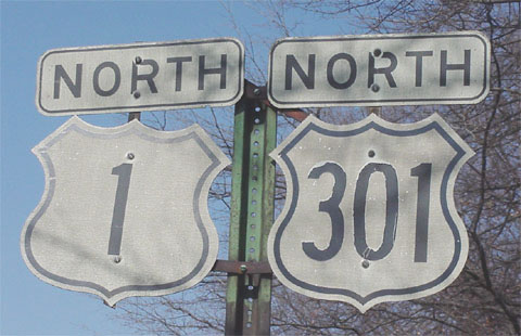
Creation: Appeared in Virginia in 1927, the same year it appeared nationally. US 1 was routed over the original VA 31. It ran very much as it does now, with some urban exceptions.
Adjustments: In Richmond, US 1 used a bridge at 9th St. up to 1929. The 1931 inset shows no 9th St. bridge at all, and US 1 used the 14th St./Hull St. Bridge to Main St. to Adams to Chamberlayne up to at least 1931. In 1932, US 1 used a new 9th Street Bridge, Broad St., and Adams Ave to get to Chamberlayne. By 1937, the Belvedere St. Bridge was built and US 1 used that to Broad, then to Lombardy and Chamberlayne. This alignment was altered in 1959 to the present US 1 direct routing Belvedere-Chamberlayne. In Fredericksburg, US 1 originally used Princess Anne St. up to at least 1941 (last inset of Fredericksburg). At some point US 1 split into one-way streets with Princess Anne and Caroline Streets, as US 1 BUs. remains today. In Alexandria, US 1 used Washington St. originally to get through downtown. Between 1934-37, US 1 began using Patrick St. Between 1945-47, US 1 was rerouted back to cut east to Washington St. (curr VA 400) and went through downtown before angling northwest on Janneys Ln back to Jefferson Davis Hwy. This option became US 1 ALT later. The 1950-59 maps show US 1 using Henry St. instead (which was US 1 ALT in the mid-40's). By 1961, US 1 was split into its current one-way alignments on Henry and Patrick Sts. Posting: Fully posted; Cutouts still up Richmond cutouts were replaced in early 2002?. Petersburg is the only city where US 1 is hard to follow based on posting; White border sign may still exist in Alexandria; error VA 1 sign existed at VA 54 in the mid-80's; Bonus error: NC 1 sign existed on NC 78 near Sanford in the early 90's. Comments: Historically the most important road on the East Coast, it has been pretty much superceded in Virginia by I-95 and I-85. It still provides a great low-traffic, four-lane alternative between Fredericksburg and Richmond. Above Fredericksburg, though, it's one stoplight after another. The last 55 mph section is between Falmouth and Stafford CH. US 1 became multilaned as early as 1937 between Richmond and Petersburg. By the mid 40's it was multilane from Petersburg to D.C. Until 1998, US 1 in Dumfries had an interesting alignment. The road split far apart. US 1 NB was straight and 2 lanes in the same direction. US 1 SB was quite crooked, and for half of it was two-way traffic, with only 1 lane in each direction. This created a bottleneck everyday during afternoon rush. VDOT added a second SB lane in 1999. US 1 below Petersburg is almost entirely 3 lane, except some 1940's 4-laning in small areas, through South Hill, and around the Roanoke River. US 1 had the last known suicide lane setup in Virginia, a little south of US 58, where both directions could come to the middle to pass. This was finally changed in 2003 or 2004. (picture) - thanks to Gribblenation | ||
| US 1 ALT Decommissioned | |||
| Previous US 1 ALT's: |
US 1 ALT #1: Appeared between 1942-44 as a newly numbered route. Ran from US 1 just South of the Pentagon to D.C. via the Memorial Bridge. No other maps I have explicitly number this road, so I don't know exactly when this went away. Much of it is now part of VA 110, which did not appear until the late 60's.
US 1 ALT #2: Described as ending in June 1947 Minutes (replaced by Mainline US 1): beginning at the intersection of Franklin and Patrick Streets, thence northerly via Patrick, Wilkes, Henry Streets and the Old Georgetown Road to [then] Route 1 just east of the Southern Railroad crossing., ` US 1 ALT #3: Appeared about 1945 (bridges are dated 1945) as the new Fredericksburg bypass from VA 51 (curr VA 208) to the Rappahannock River Bridge. US 1 ALT was renumbered as mainline US 1 in 1971. There is still (as of July 2005) a BGS on US 1 SB (thanks to Gribblenation) just south of the Rappahannock River indicating the bypass is US 1 ALT. It is extremely old looking and might be the oldest BGS in use in Virginia. A correct BGS (thanks to Gribblenation) was installed a little further north in advance of the erroneous one. US 1 ALT #4: Shown on Rand McNally 1961 Atlas and on VDOT official maps 1963-68. Was in Alexandria using the old briefly used US 1 Washington St. option. Today Washington St. is VA 400. |
||
| ROUTE LOG NC STATE LINE: 0 - 0 I-95 (exit 8): 9 - 9 EMP-GV LINE: 1 - 10 US 58 Bus: 2 - 12 US 58: 1 - 13 I-95 (exit 12): 1 - 14 GV-EMP LINE: 0 - 14 SX-GV LINE: 3 - 17 I-95 (exit 17): 1 - 18 VA 397: 2 - 20 VA 139: 1 - 21 VA 40, BEGIN VA 40 Bus: 11 - 32 VA 40 Bus WB: 0.25 - 32.25 PG-SX LINE: 2.75 - 35 I-95 (exit 37): 3 - 38 VA 35 WB: 4 - 42 I-95 (exit 41): 0 - 42 VA 35 EB: 0.25 - 42.25 VA 156: 0.25 - 42.5 I-95 (exit 45): 5 - 47.5 PET-PG LINE: 2 - 49.5 US 301 ALT: 3 - 52.5 I-95 (exit 50): 1 - 53.5 US 460 Bus EB: 0.25 - 53.75 VA 36 EB: 1 - 54.75 I-95 (exit 52): 0.25 - 55 US 301 ALT, US 460 Bus WB, US 1 SB: 0.25 - 55.25 VA 36 WB: 0.25 - 55.5 COL-PET LINE: 0.25 - 55.75 VA 144 SB: 1.5 - 57.25 CH-COL LINE: 1.75 - 59 VA 144 NB: 0.25 - 59.25 VA 366: 2.5 - 61.75 VA 10: 0.5 - 62.25 VA 288: 1.5 - 63.75 VA 145: 2 - 65.75 VA 150: 2.5 - 68.25 RIC-CH LINE: 1.5 - 69.75 VA 161: 0.5 - 70.25 US 360: 4 - 74.25 US 60: 0.25 - 74.5 VA 195: 1.5 - 76 VA 147: 0.25 - 76.25 US 250: 0.5 - 76.75 VA 33: 0.25 - 77 I-64, I-95 (exit 76): 0.25 - 77.25 VA 197: 2 - 79.25 US 301 NB, VA 2: 1 - 80.25 HR-RIC LINE: 0 - 80.25 I-95 (exit 82): 1 - 81.25 HN-HR LINE: 1.75 - 83 I-295 (exit 41): 0.25 - 83.25 VA 54: 10 - 93.25 VA 54Y: 0.25 - 93.5 CL-HN LINE: 1.5 - 95 VA 30: 4 - 99 US 301 Bus, VA 2 NB, VA 207, VA 207 Bus: 14 - 113 US 301 Bus: 2 - 115 US 17: 11 - 126 KG-CL LINE: 1 - 127 VA 3: 6 - 133 VA 205: 2 - 135 VA 218: 6 - 141 VA 206: 1 - 142 MD STATE LINE: 3 - 145 |
Creation: US 301 appeared in Virginia around 1932, the same year it did nationally. This was the 2nd attempt at US 301 in Virginia. US 301 originally ran from US 1 Petersburg south to the NC line below Emporia. This was a renumbering of the unique US 17-1.
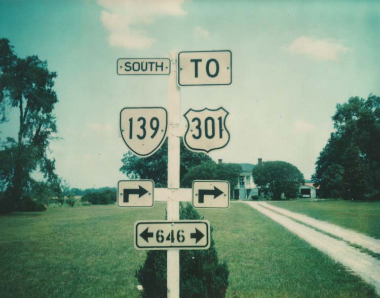
Adjustments: US 301 was extended north to its current Maryland crossing in 1940-41, as a multiplex with US 1 to Richmond and VA 2 to Bowling Green. North of Bowling Green US 301 replaced part of VA 207 up to VA 3 and was new construction north of that. The 1941 map shows US 301 as discontinuous between VA 3 and VA 205, and one would have to take SR 624 to cross the gap. A small gap also existed north of Bowling Green. Both of these gaps are gone by 1944. In 1953, US 301 was rerouted in Petersburg from using Sycamore Ave (became US 301 ALT) to Crater Rd. (replaced VA 299 #2). Posting: Fully posted; the last US 301 cutout I was aware of (Richmond) was replaced in early 2002, but here's a peek at one. Posting of US 301 between Jarratt and VA 35 is spotty (but here is a 1976 cutout on VA 139 in Jarratt!), as US 301 is the frontage road of I-95. Bonus error: A MD 301 shield exists in a shopping center off MD 197 near Bowie. Comment: North of Bowling Green, it would make a good interstate corridor along with VA 207. Maryland's portion of US 301 is quickly becoming unusable as a through route. The bridge to Md. is toll SB only ($3). US 301 has interstate-style mile markers north of VA 207. It's mostly a local road in VA below Richmond. US 301 was 4-lane south of VA 35 to Jarratt until 1981, when I-95 SB was built out of US 301 NB lanes. Right at the NC Line there is a stoplight at SR 662 - which is a dead end road. L. Corsaro and E. Smith have a US 301 expressway site detailing the arterial characteristics of US 301. US 301 #1: US 301 appeared in the 1925 US Highways plan between Fredericksburg and Lee Hall. Most of this route actually became US 17. Today this would be (in order) US 17 Bus, VA 2 to Corbin, SR 610 and Ft. AP Hill road to Rappahanock Academy, US 17 to Glenns, VA 33 to VA 14 SB to Gloucester, VA 238 to Lee Hall. | ||
| US 401 Decommissioned | |||
| Previous US 401's: | US 401: Appeared in 1929. Ran from US 15-VA 44 (curr US 15-VA 49) Clarksville to US 1 South Hill, a whopping 23 miles. From Clarksville to Boydton US 401 replaced US 15/VA 324 and from Boydton to South Hill had been part of US 15/VA 12. In 1930 or 1931, US 401 was extended west to US 501 South Boston, replacing a piece of original VA 44. US 401 was renumbered as part of US 58 in 1932. In the 1925 plan, US 401 was to continue south from Clarksville along US 15 to NC. This became part of US 15 instead. | ||
| |||||
| ROUTE LOG NC STATE LINE: 0 - 0 VA 96: 2 - 2 US 58, US 360: 9 - 11 VA 304: 0.5 - 11.5 VA 129: 0.5 - 12 VA 129: 3 - 15 VA 349: 2 - 17 VA 360 WB: 0.25 - 17.25 VA 360 EB: 0.25 - 17.5 VA 40 WB: 20 - 37.5 CB-HX LINE: 1 - 38.5 VA 40 EB: 1 - 39.5 VA 24 WB: 19 - 58.5 VA 24 EB: 1 - 59.5 LYN-CB LINE: 8 - 67.5 US 460 EB, US 460 Bus, US 501 Bus: 1 - 68.5 US 460 WB: 3 - 71.5 VA 128 NB: 0.5 - 72 US 29 NB, VA 128 SB: 0.5 - 72.5 US 29 SB: 0.25 - 72.75 US 221: 2.5 - 75.25 US 501 Bus: 3.5 - 78.75 BD-LYN LINE: 2 - 80.75 VA 122: 9 - 89.75 BLUE RIDGE PKWY: 1 - 90.75 AH-BD LINE: 1 - 91.75 VA 130 EB: 2 - 93.75 RB-AH LINE: 4 - 97.75 VA 130 WB: 2 - 99.75 VA 130Y: 0.25 - 100 BVA-RB LINE: 9 - 109 US 501 ALT: 0.25 - 109.25 US 501 ALT: 0.5 - 109.75 US 60: 0.25 - 110 |
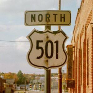
Creation: Appeared as an original 1927 Virginia US route. Originally ran from NC line at Cluster Springs to Halifax, then northeast to US 60 (curr US 460 Bus) Burkeville. This was a multiplex with VA 18 from NC to Halifax, VA 12 from Halifax to Wyliesburg, VA 32 from Wyliesburg to Keysville, and VA 20 from Keysville to Burkeville.
Adjustments: All the multiplexes were eliminated in 1929. In July 1933, US 501 underwent a large rerouting - everything east of Halifax became US 360 (today this is VA 360 and US 360). US 501 was instead rerouted north to Lynchburg (replacing VA 18), then northwest to Glasgow (replacing a rerouted US 60), and finally north to Buena Vista (replacing the last piece of original VA 14). In July 1933, US 501 was rerouted between South Boston and Halifax over what had been VA 321. The old route became current VA 129. By 1937, US 501 used Campbell Ave through Lynchburg, as opposed to 12th St., Main St., and Rivermont Ave (became US 501 ALT) In 1990, the US 501 Bypass of Lynchburg was completely finished. The earlier section between US 221 and US 29 had been part of VA 291. Posting: Fully posted; I have seen 1 US 501 cutout (thanks to Gribblenation) - it is in South Boston, NB on what is now one-way SB split of the route. It is near VA 304. Bonus error: NC 501 sign on NC 78 near Sanford existed in the early 90's. Comments: From Dave: On one random road trip in 1996, I crossed the VA/NC border at various points near US 501 to see how they marked the state line on back roads. VA didn't mark it real well, but NC went through the whole Welcome To/State Speed Limit/Buckle Your Seatbelts spiel on one back road. On a more minor back road that was unpaved, NC still had a state line sign, but managed to do without the other signs. US 501 is 4-lane from NC line to Halifax and from Rustburg to Lynchburg. The rest is original 2-lane alignments. US 501 had a related state route extension, VA 501, which used the route of current VA 39 Following US 501 BYPASS through Lynchburg requires 3 different interchange ramps, as well as two at-grade turns. | ||||
| |||||
| ROUTE LOG US 501: 0 - 0 US 501: 0.5 - 0.5 |
Creation: Unsure; goes back at least to 1993 (VDOT atlas book). I'm sure it is older than that. This is the 2nd US 501 ALT
Adjustments: None Posting: Not posted at either end, cannot verify the middle. I doubt it is posted at all. Comment: Sycamore Ave., one block west of US 501 through downtown Buena Vista. | ||||
| Previous US 501 ALT's: | US 501 ALT #1: Implied as far back as 1937. Was previously US 501 through downtown Lynchburg. Ran along Rivermont Ave., Bedford Ave., and 5th St. (curr US 29 Bus) in Lynchburg. US 501 ALT was decommissioned in 1990 when US 501 Bypass was completed. | ||||
Previous: US 170 |
Next: US 11 and Branches
Top | Virginia Hwy Index
Home
