“Climb the mountains and get their good tidings. Nature's peace will flow into you as sunshine flows into trees. The winds will blow their own freshness into you, and the storms their energy, while cares will drop off like autumn leaves.” - John Muir
I have always been fascinated by mountains. During my travels, I’ve seen many famous mountains including Mount Fuji in Japan, Mount Kilimanjaro in Tanzania, Kilauea in Hawaii and Mount McKinley in Alaska. Back in 1976, I even joined the ski club at the base I was stationed at in Germany just so I could go on their upcoming trip to Zermatt, Switzerland and see the Matterhorn. I’ve seen several volcanoes and peaks in the Andes and awoke in the middle of the night to watch Arenal Volcano in Costa Rica erupt. While in Nepal, I took a tourist flight on a B-757 over the Himalayas to see several of the tallest peaks in the world including Mount Everest.
As for climbing mountains, I only have a little experience. In 1999, I trekked 64 miles over eight days in the Himalayan “foothills” reaching about 13,000’ at one point. I attempted to climb Mount Whitney in California, the tallest peak in the “lower 48” at 14,464’, three times between 1987 and 2008 (a fourth attempt was rained out before I even got started). The closest I got to Whitney’s summit was about a half mile before I hit “the wall”. The altitude definitely gave me problems. I recently drove to the summit of Pike’s Peak (14,110’) in Colorado. It took me a while to catch my breath and get over a little dizziness up on the summit. I’ve climbed Mount Lassen in California twice. At 10,457’, Lassen is a relatively easy 2˝ mile climb gaining 2,000’ of elevation with only a little “rock hopping” near the summit.
Mount St. Helens is an active volcano located in southwestern Washington State. Before it blew its top in the major eruption of May 18, 1980, it was a beautiful mountain with a summit of 9,677’. The eruption blew away a large portion of the north face and reduced its summit to 8,365’. A lava dome is still growing inside the crater and it is still venting steam. The U.S. Forest Service is currently allowing people to climb on the south face but with warnings. You are not allowed to enter the crater because of the venting steam, rock falls, etc. They do require that all climbers purchase permits and limit the number of permits to 100 per day.
Kathy and I decided we both wanted to go back to the northern Oregon/southern Washington State area to explore the spectacular Columbia River Gorge with its 77 water falls and hundreds of miles of hiking trails. We also planned to see the coast, Lewis and Clark’s Fort Clatsop, Fort Vancouver, the Evergreen Aviation Museum and several other sites in the area. We stayed in Vancouver, Washington which is just across the Columbia River from Portland, Oregon.
Since Mount St. Helens is also nearby, I thought it would be a fun challenge to try and climb it. Kathy agreed and we started getting into climbing shape by doing several steep hikes in northern California and hitting the cardio machines at the gym harder than normal. I even climbed the stairs at home 80 times without stopping.
Over the next several days after arriving in Washington, we did a few short but steep hikes. We climbed to the top of the 620 foot tall Multnomah Falls and to the top of Beacon Rock, an 850 foot monolith along the Columbia River named by Lewis and Clark.
Finally the day arrived to attempt our climb up Mount St. Helens. We got up at 4:45 a.m. and drove about 90 miles to the trailhead at Climbers Bivouac. We stopped along the way for breakfast, to pick up our permits and register for the climb.
We donned our backpacks, boots, gaiters (to keep the volcanic ash and pebbles out of our boots) and optimistically headed up the trail at 8:50 a.m. We had packed for any eventuality: extra warm clothes, extra food, extra water and even a space blanket in case we underestimated our time and ended up spending the night on the mountain.
The first two miles of the trail is a rather gradual climb through the forest. It was very misty/rainy in the forest and we started to get wet so we broke out the lightweight ponchos we had. By the time we reached the tree line, the rain/mist had stopped but it was still not completely clear. We could only see about 50 yards.
We then entered the hardest part of the climb – about two miles of rocks and boulders. There is really no designated trail here. You just try to find the best way around and sometimes over the rocks.
About a quarter mile into the rocks, Kathy was turning around when she felt a pain in her back. She knew right away that it was bad enough that she could not continue up the mountain and she had to turn back. I didn’t want her to have to go back on her own in that condition but she insisted she could make it okay and I should continue up the mountain. We brought along two walkie-talkies for just such a scenario and they worked great. I was able to talk to Kathy the whole time until she made it back to the car which made be feel better about continuing on.
I slowly made my way up the rocks. It was still pretty misty but there were large poles with orange colored flags tied to them placed along the route and as long as I could see the next pole, I figured I was going in the right direction.
After about four hours, I came upon three people eating lunch and joined them for my lunch break. One of the guys seemed to be acting as a guide to a man and woman who appeared to be in their twenties. The man did not appear to be doing too good – he was dizzy, had difficulty catching his breath and didn’t feel he could make it all the way to the summit. He decided to go back down while the woman continued up with the “guide”. The woman was in much better shape than the man as after the man went back down the woman and the “guide” left me in their dust.
Another guy stopped to eat with us. His name was John and he actually had plans to make a two day ascent of 12,281’ Mount Adams the next day. I couldn’t believe he was going to try that right after this climb.
At the rate I was going, I figured if I could make it to the summit by 3:00 p.m., I could get back down out of the rocks before dark. Even though I had packed a good head lamp, I did not want to be climbing down the rocks after dark. I ended up hiking down Mount Whitney all night long twice and that was not fun!
Shortly after lunch, the mist/clouds started to clear up, some blue sky appeared and I could swear I saw the summit. It looked so close yet it was probably still two miles away. As I got closer, I could see what looked like ants standing on the rim and I was pretty sure I could make it. I called Kathy on the walkie-talkie and tried to give her an estimate of when I would get back so she wouldn’t have to wait in the car the whole time. She was able to drive back to Cougar about 18 miles away and have dinner there. She told me the walking back down and around the car made her back feel a little better.
After about two miles of rock hopping, the terrain turns to a moonscape of volcanic ash and small pebbles. A man I passed coming down told me while trying to climb in it, you take two steps forward and slide one step back. It wasn’t quite that bad but by the time I entered this area, I was really getting winded. I didn’t want to take a break so I would take about 25 steps and stop and take 25 breaths. I felt like those guys you see struggling up Mount Everest taking about 30 seconds to take one step. John was about 30 yards ahead of me and I was happy I was keeping pace with him.
My backpack was starting to feel a little heavier now so I decided to leave it by a rock about a half mile from the summit. The backpack held my camelback containing all my water but I figured I could make it up and back to the backpack without dying of thirst. I had brought a mask to protect against the blowing ash but also left it in the backpack (I was probably too tired to think clearly). I did remember to pull out the camera though!
Finally, at 3:30 p.m., I reached the summit rim! Unfortunately, clouds would form and disappear inside the crater so the view was spotty at best. On a clear day, the view would include the entire mile wide crater as well as several nearby volcanic peaks. There isn’t much room on the rim so I sat with my feet dangling over the edge looking down at the steaming lava dome a few thousand feet below. The USGS advises against doing that as the rim is unstable but as I said, I probably wasn’t thinking too clearly. There were about seven other people up there at the time including a group of guys who had brought up bottles of wine to toast the occasion. I think they had been up there about an hour.
“I don’t know where I’m a gonna go when the volcano blows.” – Jimmy Buffett
After resting and enjoying the partial views on the summit for about 30 minutes, I headed back down. I definitely got down the moonscape area much faster than it took going up. I picked up my backpack and headed into the rocks. At this time, the clouds below me really cleared up and I could see much more of the surrounding area including Mount Adams about 31 miles away, the forest and a lake.
John caught up with me and we ended up hiking down most of the rest of the way together. I thought we were the last two coming down until another guy appeared out of nowhere further down.
Once we got back into the rocks, the going was a lot slower. You really had to be careful how you step over and down the rocks as it was easy to get your foot caught between rocks or even lose your balance and hit your head. My trekking poles saved me while hiking down several times. John had stowed his poles going down as he “never learned how to use them”. At one point, he lost his balance and lost about an inch of skin off of his knee in the process. He then decided to use his poles and was surprised how much they helped.
At around 5:00 p.m., I called Kathy on the walkie-talkie and told her I was in the rocks and hoped to be back in a few hours. I could now see the trail coming out of the forest but John and I both weren’t sure that was the right trail. Since we couldn’t see far in the mist coming up, we didn’t recognize the trail when it was now clear. About this time, the other guy that joined us whipped out his hiking GPS and assured us we were on the right trail.
We made it back to the forest at dusk. There is a toilet shortly after you get in the forest and John stopped to use it. I really wanted to get back and asked John if he was OK (because of his banged-up knee) and if he had a light. He said he was fine so I continued down.
After about a mile into the forest, it was starting to get really dark. I could barely see the trail but I was too tired to get my head lamp out. I kept going until it was completely dark and trees were starting to look like Big Foot. I tried calling Kathy on the walkie-talkie but there was no answer now. The batteries were fine so I was wondering if I somehow got off on the wrong trail and was now out of range for the walkie-talkies. I started thinking I should have gotten my head lamp out sooner and I probably should have waited for John or the other guy.
I finally got up enough energy to take off my backpack and pull out my head lamp. It worked great and I finally saw a blue diamond marking on a tree meaning I was on the right trail. There actually is only one trail in that area but my mind was starting to play tricks on me. I wasn’t even sure if I was going downhill!
Just before reaching the trailhead, the guy with the GPS caught up with me and I was able to talk to Kathy on the walkie-talkie again. Kathy was waiting near the trailhead but when we both came out into the open, she couldn’t tell which one was me as our head lamps were blinding her.
I was really glad to see Kathy, gave her a hug and told her “if I ever suggest climbing a mountain again, just say no”. I was so tired and out of breath that I asked Kathy if she could drive back to Vancouver. Her back was still hurting but she was able to drive without too much discomfort. She bought a six-pack of beer in Cougar so I could have a cold one after getting back to the car. I really appreciated that and really wanted to drink one. However, I thought if I did drink a beer I probably would have guzzled it causing me to throw up. I decided to wait until we got back to the hotel in Vancouver to celebrate. Kathy was a real trooper having to wait in the car for many hours until I got back down and driving with her back hurting.
It took me 6˝ hours to get to the summit and 4˝ hours to get back down. I only took two 30 minute breaks on the 10 mile trek – one for lunch and the one on the summit. The altitude gain was 4,500’ and most of that seemed to be above the tree line. After about two days, the soreness in my legs went away and I started rethinking my “just say no” statement. Who knows? Maybe I’ll try Half Dome in Yosemite next.
After returning home, I remembered a small cemetery I came upon in Zermatt, Switzerland within sight of the Matterhorn. In it, I saw a grave of a young American. On his tombstone was inscribed “I chose to climb”. While Mount St. Helens is definitely not the Matterhorn, I’m happy I chose to climb and lived to tell about it!
To view 17 photos of the climb, click on the forward arrow below this photo.
 Mount St. Helens is an active volcano located in southwestern Washington State. Before it blew its top in the major eruption of May 18, 1980, it was a beautiful mountain with a summit of 9,677’. The eruption blew away a large portion of the north face and reduced its summit to 8,365’. A lava dome is still growing inside the crater and it is still venting steam. The U.S. Forest Service is currently allowing people to climb on the south face but with warnings. You are not allowed to enter the crater because of the venting steam, rock falls, etc. They do require that all climbers purchase permits and limit the number of permits to 100 per day.
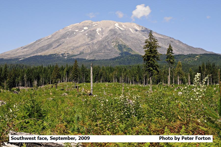 I slowly made my way up the rocks. It was still pretty misty but there were large poles with orange colored flags tied to them placed along the route and as long as I could see the next pole, I figured I was going in the right direction.
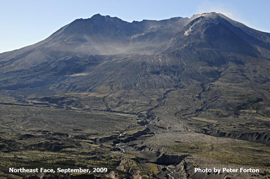 At around 5:00 p.m., I called Kathy on the walkie-talkie and told her I was in the rocks and hoped to be back in a few hours. I could now see the trail coming out of the forest but John and I both weren’t sure that was the right trail. Since we couldn’t see far in the mist coming up, we didn’t recognize the trail when it was now clear. About this time, the other guy that joined us whipped out his hiking GPS and assured us we were on the right trail.