
Arizona and Colorado
March 27 - April 3, 2004

| Arizona and Colorado March 27 - April 3, 2004 |
|

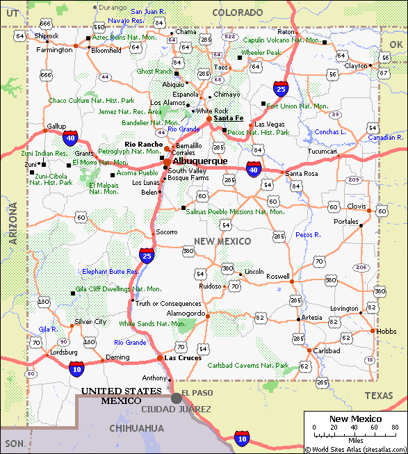
After a short flight from Sacramento, Kathy and I landed in Albuquerque, New Mexico, got our rental car and headed east on another road trip through the great Southwest. On this trip, we decided to concentrate on the sites and scenery of New Mexico with short excursions into Arizona and Colorado. New Mexico has 13 National Parks, Monuments and Historical Sites. Alaska, California and Arizona are the only states with more National sites.
![]() Our first stop was El Malpais National
Monument. We saw the eastern half including the sandstone bluffs and La Ventana
Natural Arch and then spent the night in Grants. The next day we saw the
western half of El Malpais hiking up Bandera Crater along lava tubes and going
to the entrance of an ice cave where the temperature never rises above 32
degrees. The floor of the cave is covered in ice up to 5 feet thick.
Our first stop was El Malpais National
Monument. We saw the eastern half including the sandstone bluffs and La Ventana
Natural Arch and then spent the night in Grants. The next day we saw the
western half of El Malpais hiking up Bandera Crater along lava tubes and going
to the entrance of an ice cave where the temperature never rises above 32
degrees. The floor of the cave is covered in ice up to 5 feet thick.
From El Malpais, we drove about 20 miles to El Morro National Monument. El Morro is a cuesta - a long formation with a gentle upward slope that drops off abruptly at one end. At the base of El Morro is a natural pool that is the only source of water along an ancient trade route. One of the interesting features at El Morro is many of the travelers that came through this area carved their names and messages in the rock. The inscriptions on the rock range from ancient Native-American petroglyphs to Spanish explores to U.S. Army Cavalrymen.
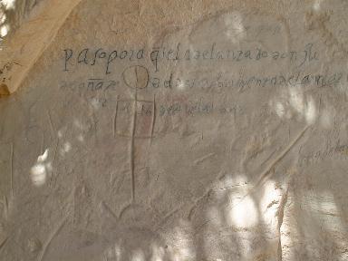 El Morro National Monument: Oñate Inscription |
The most famous inscription was carved by Don Juan de
Oñate in Spanish on April 16, 1605 - the first known historical
inscription on the rock. There are hundreds of inscriptions that you can read,
some so neat that it looks like a machine must have been used. We hiked to the top of El Morro which is 7,460 feet (2,273 meters) at the highest point. At the top are two Anasazi Pueblo ruins, the largest dating to AD 1275. |
The Anasazi, a Navajo word meaning ancient enemy, were ingenious farmers and master builders. Their earliest structures, half-buried pithouses, evolved into above-ground pueblos by AD 1000. They built many pueblos on cliffs and in caves. Some of these pueblos were up to five stories tall and contained hundreds of rooms - ancient condominiums. They also built square or round kivas-underground chambers that were used for informal gatherings and religious ceremonies. The Anasazi ruins at El Morro would be the first of dozens of ruins we would see on this trip.
![]() Our next stop was Zuni Pueblo - a small town
on the Zuni Indian reservation. We stopped in one of the few shops open on
Sunday and the Middle-Eastern man (where were the Zuni people?) behind the
counter said we could take 50% off everything in the shop. I ended up buying a
Zuni fetish. Fetishes are tiny animals carved out of different stones. I also
bought pottery made by Michael Charley, a well-known Navajo artist. Later I
would see some of his work in shops in Santa Fe and I found out I really did
get a good price.
Our next stop was Zuni Pueblo - a small town
on the Zuni Indian reservation. We stopped in one of the few shops open on
Sunday and the Middle-Eastern man (where were the Zuni people?) behind the
counter said we could take 50% off everything in the shop. I ended up buying a
Zuni fetish. Fetishes are tiny animals carved out of different stones. I also
bought pottery made by Michael Charley, a well-known Navajo artist. Later I
would see some of his work in shops in Santa Fe and I found out I really did
get a good price.
From the Zuni Pueblo, we drove through Gallup and into Arizona ending up at Chinle where we spent the night. Chinle is located right at the entrance to Canyon de Chelly (pronounced d'SHAY) National Monument.
|
The next day, we toured Canyon de Chelly which actually
contains two large canyons that merge together as well as several smaller
canyons just west of Chinle. We first drove along the rim of Canyon de Chelly
to Spider Rock Overlook where you can view, you guessed it, the 800 foot-high
Spider Rock. The Canyon walls rise 1,000 feet high here and this is the most
spectacular view in the monument. It was great being there early in the morning
as we had the place to ourselves and it was so quiet.
|
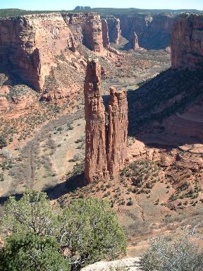 Canyon de Chelly: Spider Rock |
 Durango, Colorado |
On our way to Colorado, we drove by Shiprock, the basalt core of an old volcano that rises 1,700 feet (518 meters) above the desert. We could actually see Shiprock from over 100 miles away on a previous trip in Utah. At sunset, Shiprock appears to shimmer and float, hence the name. We almost stopped at Four Corners (I have been there but Kathy hasn't) but it was getting late so we pushed on to Durango, Colorado where we spent the night. |
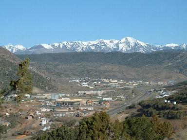
The next day, after seeing the historic Strater Hotel in Durango, we headed south back into New Mexico to Aztec Ruins National Monument. Contrary to the name, this large Pueblo complex was not built by the Aztecs of central Mexico. Early Anglo settlers named the site Aztec thinking it was built by them but it was actually built centuries before the Aztecs lived. The West ruin is the largest ruin containing about 400 rooms in three stories. As I walked through some of the rooms, I tried to go back in time and imagine what life must have been like when this was a thriving community. The site also contains the only reconstructed kiva in the Southwest called the Great Kiva.
![]() From Aztec Ruins, we drove south to Chaco
Culture National Historical Park. While Aztec Ruins is located right next to
modern houses, Chaco Culture is truly out in the middle of nowhere. The last 16
miles of road to the entrance of the park is gravel but the pueblo ruins there
are worth seeing. The largest of many ruins here is Pueblo Bonito which was
built from the mid-800s to the 1200s. It towered four stories high and
contained more the 600 rooms and 40 kivas. At another ruin, we saw a room where
macaw skeletons were found proving that trade took place with people who lived
as far away as Mexico.
From Aztec Ruins, we drove south to Chaco
Culture National Historical Park. While Aztec Ruins is located right next to
modern houses, Chaco Culture is truly out in the middle of nowhere. The last 16
miles of road to the entrance of the park is gravel but the pueblo ruins there
are worth seeing. The largest of many ruins here is Pueblo Bonito which was
built from the mid-800s to the 1200s. It towered four stories high and
contained more the 600 rooms and 40 kivas. At another ruin, we saw a room where
macaw skeletons were found proving that trade took place with people who lived
as far away as Mexico.
After driving down into a steep, narrow gorge and crossing the not so Rio Grande (only about 20 feet wide at this point), our next stop was Taos where we arrived in time for our free glass of wine and cheese at the hotel. Unfortunately, they were out of the cheese but the wine was good. Taos is an artists' colony and has many studios, galleries and shops. It was pretty dead as the tourist season was still a few weeks away but it was nice not having to deal with large crowds. We saw the old town plaza and the San Francisco de Asís Church which is a heavily buttressed adobe structure built in 1816. It appears in works by photographer Ansel Adams and painter Georgia O'Keeffe. The back of the church is very strange looking, unlike any church I have seen. Also, if you look close, you can see the straw in the adobe walls.
|
Our next destination was Fort Union National Monument. Fort Union was the principle quartermaster depot of the Southwest and was located along the Santa Fe Trail. You can still see the wagon wheel ruts from the famous trail at the fort. The first fort at this location was built in 1851. The second fort was a massive earthwork built in 1861 and was built to defend the Santa Fe trail against a threatened Confederate invasion. The fort never saw that action as the Confederate invasion was halted and turned back in March 1862 by a force of Colorado and New Mexico volunteers and U.S. regulars from Fort Union at the Battle of Glorieta Pass, about 20 miles southeast of Santa Fe. |
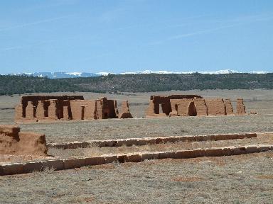 Fort Union National Monument |
The third fort was built in 1863 and was abandoned in 1891 when it outlived its usefulness. Contrary to what you see in the Hollywood Westerns, most of the U.S. Army forts did not have log walls around them. Fort Union didn't need the walls because there were so many troops stationed there, the Indians never attacked it. However, troops from Fort Union did leave the fort to battle the Apaches, Navajos, Cheyennes, Arapahos, Kiowas, Utes and Comanches at various time throughout the fort's history.
Today, you can walk around the stone building foundations, adobe walls and paved sidewalks of the fort. It is kind of eerie actually. They had all the conveniences of home even though the fort was located in the middle of nowhere. Near the Mechanics Corral, there are some old wagons and wagon wheels. The photo on last year's National Parks Pass of a wagon wheel was taken here. We plan to enter the next photo contest using the best photo from all the National Parks, Monuments, etc. we have taken during the last year.
From Fort Union, we headed south stopping in Las Vegas, New Mexico. My dad went to basic training in Las Vegas during World War II at Camp Maximiliano Luna and I was curious if there was still a military base there. We stopped at the Chamber of Commerce/Tourist Information office where we found out that an Army National Guard armory and a community college are now located at the site Camp Luna was located at. Unfortunately, we still had another destination and not much time so we pressed on without checking out the site.
![]() Our next destination was Pecos National
Historical Park. Pecos was interesting because it contains the ruins of a large
(150 feet from the entrance to the altar) mission church first built in the
early 1600's and rebuilt in the early 1700's. Also, while much of the ruins at
other sites we visited were excavated, the ruins of the North Pueblo in Pecos
are mostly still buried under mounds of dirt. We could only imagine what the
four and five story buildings looked like from 1450-1550 during the peak years
of the Pueblo.
Our next destination was Pecos National
Historical Park. Pecos was interesting because it contains the ruins of a large
(150 feet from the entrance to the altar) mission church first built in the
early 1600's and rebuilt in the early 1700's. Also, while much of the ruins at
other sites we visited were excavated, the ruins of the North Pueblo in Pecos
are mostly still buried under mounds of dirt. We could only imagine what the
four and five story buildings looked like from 1450-1550 during the peak years
of the Pueblo.
From Pecos, we pressed on to Santa Fe where we ate a typical Southwest dinner. The food didn't seem much different than Mexican food to me but was good. We spent the night in Santa Fe which is the second oldest city in the U.S. (after St. Augustine, Florida), established in 1610 as the capital of the new Spanish colony called New Mexico. Today, Santa Fe like Taos is an artist community with hundreds of shops and galleries.
We usually check out the state capitol buildings when we visit capital cities and New Mexico's state capitol is really different than most of the others. It was dedicated on December 4, 1966 and was built in New Mexico traditional style, which is an adaptation of Greek revival and Pueblo adobe architecture. The building forms the Zia sun symbol.
We walked around the old plaza where on one side Native Americans sell jewelry and artwork. Kathy picked up a pair of really cool and unique spiral earrings from one vendor there. During World War II, the mailing address for the scientists and workers at the secret Los Alamos facility was located here.
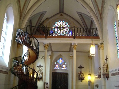 Loretto Chapel: Miraculous Staircase |
About a block from the plaza, we saw the Loretto Chapel built in the 1870's and fashioned after the Sainte-Chapelle in Paris. The chapel had one design flaw: there was no way to get to the choir loft from the chapel and a conventional staircase would take up too much room. Seeking divine guidance, the Sisters of the chapel made a Novena to their patron saint, Saint Joseph the Carpenter. As legend has it, on the ninth and final day, a mysterious carpenter arrived to design and construct a circular staircase to the choir loft. The tools on his donkey were just a saw, carpenter's square, a hammer and tubs in which to soak the wood. |
The Carpenter's "Miraculous Staircase" contains 33 steps in two full 360-degree turns. The staircase has no center support, nor is it held from its sides and not a single nail was used. When the staircase was completed, the carpenter disappeared without seeking payment. The handrails were added later.
We also saw the St. Francis Cathedral, a towering Romanesque cathedral built of sandstone and a lightweight volcanic rock located near the plaza. This chapel contains beautiful brightly colored stained-glass windows.
|
From Santa Fe, we drove 48 miles northwest to Bandelier National Monument. This is one of the more popular National Monuments in New Mexico and in late spring and summer, people are sometimes turned away. I really liked Bandelier because in addition to the pueblo ruins, kivas, petroglyphs and cliff dwellings found in most of the National Monuments and National Historical Parks we visited on this trip, Bandelier is located in a beautiful forest with rugged and steep canyons. Its average elevation is 7,000 feet (2,133 meters). Also, for something different, we climbed several ladders totaling 140 feet to get to a large ceremonial cave. |
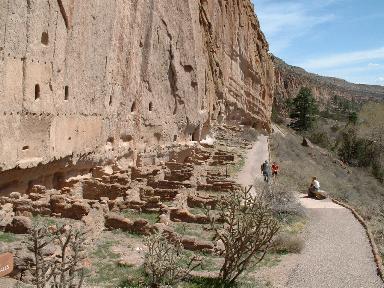 Bandelier National Monument: Long House Ruins |
Just outside of Bandelier is located the huge complex of the Los Alamos National Laboratory. We drove by several different sites of the Lab before arriving in the town of Los Alamos where we saw the Bradbury Museum named after the first Director of the Lab. We viewed a film about the Manhattan Project, America's top secret project to develop an atomic bomb during World War II which took place at the then secret Los Alamos Lab. It was great seeing the film and museum as our final destination on this trip was the Trinity Site where the world's first atomic bomb was tested. Some of the original buildings used for the Manhattan Project were destroyed by the huge Cerro Grande fire in 2000 fire that threatened much of the Lab as well as the town of Los Alamos.
![]() From Los Alamos, we had a fairly long drive
through the mountains arriving back in Albuquerque in the evening. The next
morning, we went to Petroglyph National Monument which is located in a suburb
of Albuquerque. In fact, new houses are going up just a few hundred yards from
some of the hundreds of petroglyphs there. This was our first day of rain on
the trip but that didn't stop us from hiking a trail containing hundreds of
petroglyphs. We saw the symbol of the Monument on one rock, a Petroglyph
depicting a Macaw. Unfortunately, we also saw some modern day "Petroglyphs".
Some people can be real idiots!
From Los Alamos, we had a fairly long drive
through the mountains arriving back in Albuquerque in the evening. The next
morning, we went to Petroglyph National Monument which is located in a suburb
of Albuquerque. In fact, new houses are going up just a few hundred yards from
some of the hundreds of petroglyphs there. This was our first day of rain on
the trip but that didn't stop us from hiking a trail containing hundreds of
petroglyphs. We saw the symbol of the Monument on one rock, a Petroglyph
depicting a Macaw. Unfortunately, we also saw some modern day "Petroglyphs".
Some people can be real idiots!
After Petroglyph National Monument, we drove around the plaza in the Old Town of Albuquerque but the rain was really coming down so we decided to press on to our next destination.
We drove south from Albuquerque and decided at the last minute to make a 66-mile round trip detour to see one more National Monument - Salinas Pueblo Missions National Monument. This National Monument is actually three separate sites spread out in a 20-mile radius. We just visited the Abó Site seeing the ruins of the mission and Pueblo there.
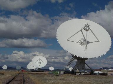 National Radio Astronomy Observatory: Very Large Array Radio Astronomy Telescope |
After our final fill of ruins, our next stop was a little more modern: the Very Large Array (VLA) radio astronomy telescope operated by the National Radio Astronomy Observatory located about 55 miles east of the town of Socorro. The VLA is actually a total of 27 antennas, each one 82 feet (25 meters) in diameter, mounted on self-propelled transporters moving on parallel sets of railroad tracks set up in a large "Y" configuration. The antennas can be moved from where they are all crowded to within 2,000 feet (610 meters) of the array center to where they stretch out 13 miles (21 kilometers) from the center depending on how much detail they want on the radio images. |
The radio images received by the VLA can be converted into actual images similar to those received by optical telescopes. If one antenna was built to equal the radio picture received by the VLA, it would have to be 22 miles (36 kilometers) in diameter! The VLA was featured in the move Contact but unlike in the movie, it wasn't designed to receive radio transmissions from extraterrestrials.
After touring the VLA, we drove back to Socorro where we spent the night. After dinner there, we parked the car to watch a spectacular lightning show. We might see lightning in Sacramento only two or three times a years so we really enjoyed the show.
|
The next day, we drove to our final destination, the
Trinity Site located within the huge White Sands Missile Range. As mentioned
earlier, Trinity Site is where the world's first atomic bomb was successfully
tested at 5:30 a.m. on July 16, 1945. The site is open to the public only twice
a year - the first Saturday in April and the first Saturday In October. It is
on a military base so you cannot take any photos until you get to the site.
Even though it rained off and on, there were still thousands of people there to
see this historic place. Everything was well organized by the military and
volunteers. There is a marker at "Ground Zero" and you can still see the steel
footing of one of the towers that held the "Device". They have photos on
display, and other items such as samples of Trinitite, the green glass-like
rocks formed when the heat from the blast fused the sand. |
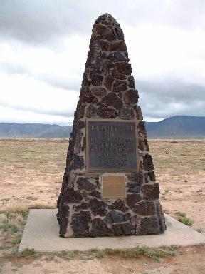 Trinity Site: Ground Zero Marker |
There was a group of teenagers there with a Geiger counter. I didn't ask them how much radiation it was detecting but from what I read before going there, if you spend one hour at Ground Zero, you will be exposed to one half millirem of radiation. By comparison, a chest X-ray exposes you to six millirems and a CAT Scan exposes you to 110 millirems of radiation. Neither of us now glow in the dark so I guess we'll be OK.
We took a shuttle bus from the Trinity Site to the Schmidt/McDonald ranch house where the plutonium core of the "Device" was assembled. The house is located two miles from Ground Zero and sustained only minor damage from the blast. Seeing the Trinity Site was quite a unique experience that most people in the U.S. probably don't even know about.
From the Trinity Site, we drove north back to Albuquerque. We drove around the city a bit and found a section of the Historic Route 66 (we plan to drive the entire Route 66 from Chicago to L.A. some day) before heading to the airport and our flight back to Sacramento.
Except for the last few days of on and off rain, the weather was great. It had snowed in a few of the places both just before and just after we were there so we were lucky. We drove 1,760 miles (2,832 kilometers) and saw nine National Monuments and National Historical Parks on this trip. On earlier trips to southern New Mexico, Kathy saw Gila Cliff Dwellings National Monument and I Saw Carlsbad Caverns National Park and White Sands National Monument as well as Roswell and Alamogordo. After seeing so much of New Mexico, I've come to the conclusion that this state truly is the "Land of Enchantment"!
 |
![]()
![]()