Destination: Utah
September 18 - 26, 2002
|
Destination: Utah September 18 - 26, 2002 |
|
Utah has 13 national parks and monuments located mostly in the southern half of the state. Only Alaska has more national parks, preserves, etc. The area that encompasses southern Utah, northern Arizona, the southwest corner of Colorado and the northwest corner of New Mexico is known as the Grand Circle. I have been to many of the Grand Circle sites on a previous trip but only a few in southern Utah. Kathy and I decided this would be a great area to explore and hike in. While our previous trips have been by air and then rental car, we decided to take my car on this trip driving on historic Highway 50 most of the way.
Highway 50 stretches almost completely across the United States between Sacramento, California and Ocean City, Maryland. There is actually a sign here in Sacramento that reads: Placerville 46, South Lake Tahoe 107 and Ocean City, MD 3073. We didn't travel quite that far on it but we did take it all the way across Nevada and into Utah. The stretch we were on goes through the basin and range of Nevada and is known as the "Loneliest Highway in America".
| Our first stop in Nevada was the Shoe Tree located just off the highway in the middle of nowhere about 125 miles east of Reno. The Shoe Tree is a lone cottonwood that has hundreds of pairs of shoes in it hanging by shoe strings. Legend has it that the first pair was thrown during a wedding night argument by a young couple. Later, their children's shoes were added to the bough. I first saw this tree several years earlier on a 530 mile journey to Lehman Caves in Great Basin National Park so we each came prepared with an old pair of shoes. Kathy tried first but it wasn't as easy as it looked. After several comedic attempts (one car stopped to watch us), we both added a pair to the tree. We wondered how some of the shoes got way up in the top of the tree which could be over 60 feet high. | 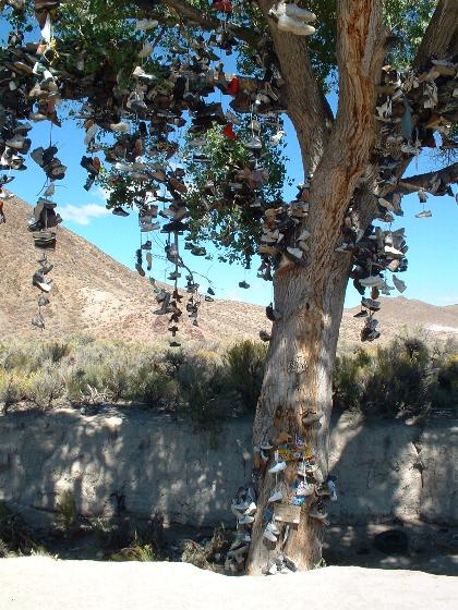 Shoe Tree, Nevada |
After brushing the dust off, we hopped back in the car and headed east. There were several Pony Express and Wells Fargo Stage stations along this route and we stopped to look at some of the ruins. Other than that, it was wide open country.
I figured this was a good place to see how fast my new Mitsubishi Eclipse GT could go as the road was straight, you could see for at least 100 miles in all directions and there was no one in sight. I slowly pushed the gas pedal all the way to the floor and even with two people and a car full of stuff, we hit 130 m.p.h. (209 k.p.h.). Kathy even videotaped the speedometer. That was fun but once is enough!
After, driving 438 miles (this was the longest leg of the trip), we ended up at Ely, Nevada. Kathy picked a great place to stay there - the historic Hotel Nevada. When opened in 1929, it was the tallest building in Nevada at six full stories and the first fire-proof building in Nevada. Many famous people including movie stars have stayed there over the years and each room is named after one. Our room was the Charley Pride room and it had Charley Pride memorabilia such as record album plaques on the wall. There was a casino downstairs and the place really had a great personality.
The next day we drove 380 miles to Moab, Utah stopping to take in some of the spectacular scenery along I-70. Moab is a tourist town being the gateway to Arches and Canyonlands National Parks. We stayed at "Moab's famous" Apache Motel, one of several throughout the west where John Wayne stayed while he filmed some of his westerns. Moab even has a few legal brew pubs - really hard to find in Utah!
We headed out early the next morning to Arches National Park as we planned to do a lot of hiking there (and most of the other places we planned to go to). We purchased a National Parks Pass for $50 at the entrance. It's a great deal considering all of the national parks and monuments we planned to see on this trip and in the next 12 months. Many parks now charge $20 per car entrance fee so we figured the pass was the way to go.
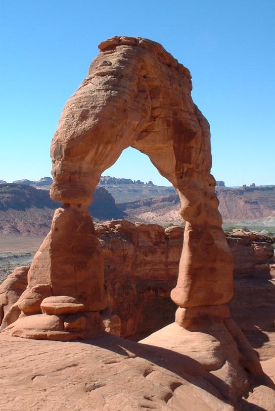 Delicate Arch, Utah |
Arches National Park contains more than 2,000 cataloged
arches - the greatest density of natural arches in the world. Without going
into a long geology lesson, the arches in the park were created over millions
of years by uplifting of salmon-colored Entrada Sandstone or buff-colored
Navajo Sandstone. Then erosion by wind, rain and ice carved out the arches.
Natural bridges look similar to natural arches but are formed by streams
changing course and eroding the rock to form the openings. We saw most of the major sites in the park. My favorite arch was Delicate Arch. You have to hike 1.5 miles and climb 480 feet to get to it but it is awesome. It stands on the brink of a canyon - the last place you'd expect to find an arch. It has to be the most photographed arch and is the symbol of the park. It's also pictured on the Utah license plates. |
Another favorite arch is Landscape Arch which stretches 306 feet across a yawning void. In 1991, a piece of rock about 60 feet long, 11 feet wide and 4 feet thick fell from the arch so you can only hike to within a few hundred yards of it now for safety reasons.
There are all kinds of unusual rock formations in Arches National Park besides arches and Balanced Rock is one of the greatest. It is a huge rock that seems to defy gravity by sitting on top of a base. Eventually, the softer base will erode enough and the balanced rock will fall.
By mid-afternoon, it was time to head over to Canyonlands National Park - a much larger park that is broken into three districts. The canyons of this park were formed by the Green and Colorado Rivers which join at the confluence in the heart of the park. We hiked in the Island in the Sky district along a trail with some incredibly steep drop-offs. At one point I asked Kathy if she would take my photo sitting with my feet dangling over the edge. She took it but made me give her the car keys first just in case. Anyway, I survived and we ended up at an overlook just in time to watch the sunset.
To me Canyonlands is even more spectacular than the Grand Canyon which is several hundred miles down the Colorado River and past Lake Powell. It would be a great place to go rafting and there are many companies in Moab that provide raft trips.
| After spending another night in Moab, we headed out for another district in Canyonlands called The Needles. We did some hiking there and then headed out of the park and stopped at Newspaper Rock. We would see many pictographs and petroglyphs on this trip but Newspaper Rock was the most impressive. The side of the cliff is covered with hundreds of ancient Native American pictographs and petroglyphs from three distinct periods. | 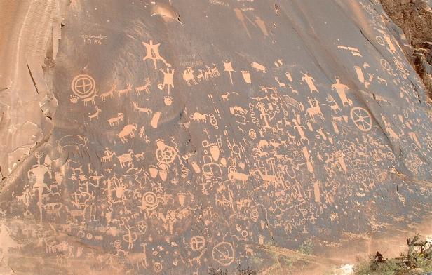 Newspaper Rock |
We can only guess what the symbols, wheels, animals and strange looking people mean. Perhaps they were a form of ancient gang graffiti.
We continued on to Blanding, Utah where we spent the night. The next day we went to Natural Bridges National Monument. The big attraction there is the three huge natural bridges called Owachomo, Kachina and Sipapu which is the largest rising 220 feet and spanning 269 feet. We went on our longest hike of the trip here descending into a canyon and hiking along a streambed between two of the bridges, climbing the canyon wall and then traversing over the high desert back to the starting point.
As we were hiking through the high desert I heard a sound that I thought might be a loud bee. We stopped and looked down and saw that we probably just missed stepping on a midget faded rattlesnake that was crossing the trail. These snakes are only about 18 inches long and the only time someone was bitten by one in the park was when a drunk guy picked one up. That was the first time I saw a rattlesnake in the wild and according to the park ranger we reported it to, it's very rare to see those snakes on the trails. We also saw a few lizards but we never spotted the beautifully marked collared lizard.
Our next stop was Torrey, Utah where we spent the night at Austin's Chuckwagon Motel. We took a dip in the pool and used the spa there. Both felt great after a long day of hiking.
Capitol Reef National Park was our next day's destination. The park preserves the Waterpocket Fold, a 100 mile long wrinkle in the Earth's crust containing a spectacular jumble of eroded cliffs, massive domes, soaring spires, stark monoliths, twisting canyons, and graceful arches. This fold created a barrier for early explorers. Back in those days, the nautical term reef was commonly used to describe any barrier, even land barriers. The domes reminded them of a capitol dome so that is how the park got its unusual name.
One of the places we hiked in Capitol Reef National Park was Capitol Gorge, a deep gorge which narrows to about 10 feet wide at one point. This is another place you wouldn't want to be in a flash flood which occurs there occasionally. Native American petroglyphs can still be seen on the gorge walls and one area is called the Pioneer Register. Early pioneers, miners and explorers passing through this gorge carved their names and dates here. The earliest date you can read is 1871.
Some other interesting sites in Capitol Reef National Park we saw were the Fruita Historic District, a 19th century Mormon settlement containing the Gifford Homestead, a fruit orchard and a one room schoolhouse used up to 1941. Also in this area we listened to a park ranger's talk about an incredible wall containing Native American petroglyphs and pictographs some of which depict humans with very strange looking heads (or helmets?).
After leaving Capitol Reef National Park, we drove along Highway 12, which Car and Driver magazine has called "the most scenic drive in America", to Panguitch, Utah. The main street in Panguitch where our hotel was located looks like it is in a time warp from the 1920's. This was definitely small town America.
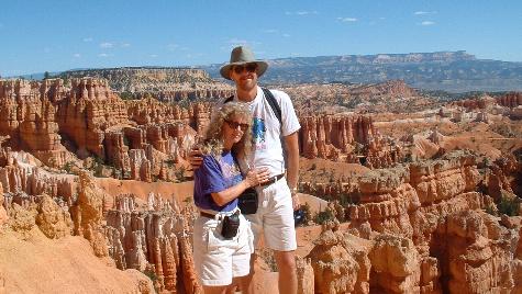 Bryce Canyon National Park (livin' on the edge) |
The next day, we drove to Bryce Canyon National Park which is a geologic wonderland. Weathering and erosion have produced what is probably the Earth's most famous example of pinnacled badlands. The first trail we hiked there was the Navajo Loop and it was unlike any trail we have ever hiked. We went down into a deep narrow chasm on switchbacks and saw spires |
(the most famous is called Thor's Hammer), niches, arches, natural stucco and tall trees growing in very narrow spaces - a very surreal landscape.
After a full day of hiking and watching the sunset magically change the color of the Bryce Canyon amphitheater pinnacles, we decided to splurge and have a really nice dinner at the Bryce Canyon Lodge, built in 1924-25. It was a great way to end a perfect day.
We started early the next day as we planned to drive 353 miles to Tonapah, Nevada and also see several things along the way. We caught the sunrise just outside of Panguitch. We also saw some nice fall color and several deer along the highway on our way to our first stop, Cedar Breaks National Monument.
Cedar Breaks National Monument looks a lot like Bryce Canyon only on a much smaller scale. We hiked a two mile trail to Spectra Point, at 10,285 feet, the highest place we hiked on the trip. Along with a spectacular view from the point there is a 1,600-year-old bristlecone pine tree located there. Just as we made it back to the car, it started sprinkling. This was the first and only rain we had on the entire trip.
Our route took us to within 20 miles of the north entrance of Zion National Park. We visited Zion earlier in the year and it is one of our favorite places. We were only in the southern part of the park then so we decided to take the short detour and see some of the Kolob Canyon in the north part. We hiked a short distance to a picnic area and had our lunch there.
After lunch, the next stop was the Little A'le' Inn in Rachel, Nevada. Rachel is a "town" made up of mostly trailers located in the middle of nowhere near Area 51, the top secret base at Groom Lake (a dry lakebed) where the government "Black Projects" are tested. Area 51 is also known for its UFO activity and the Little A'le' Inn, a restaurant/bar/inn, is a landmark there. The highway that leads to Rachel has officially been named the Extraterrestrial Highway. I actually was there several years earlier when I drove from Las Vegas and found the dirt road that leads to the fence of the base. I didn't want to get shot by the Cammo Dudes (guards driving SUVs) so that's as far as I went and we didn't go near the base this time.
The inside of the Little A'le' Inn reminded me of a redneck bar in the south during the 1950's. Among all the alien and UFO photos and paraphernalia, there were dozens of anti-Clinton, anti-gun control, etc., stickers. We each had an alien burger and a beer and never revealed our liberal leanings so a good time was had by all.
We made it to our hotel in Tonopah, Nevada in the early evening. It had been a very long day so even though it was cold and windy there, we took advantage of the outdoor spa. They had free Internet access at the hotel so we also checked our emails - nothing but spam.
| The next day, we started out on our final leg of the journey, a "short" 390 mile route back to Sacramento. We weren't done sightseeing however and our first stop was Bodie State Historic Park, California, a well preserved ghost town located in the high desert just north of Mono Lake. | 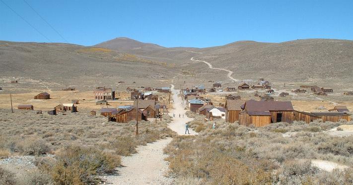 Bodie, California |
Bodie was a gold-mining town founded in 1859. By 1879, Bodie boasted a population of about ten thousand and was second to none for wickedness, badmen and "the worst climate out of doors". One little girl, whose family was taking her to the remote and infamous town, wrote in her diary: "Goodbye God, I'm going to Bodie". Killings, robberies, stage holdups and street fights occurred on a daily basis in Bodie, and its 65 saloons offered a great place to relax after a hard day in the mines.
Eventually after a series of fires destroyed about 95% of its buildings, Bodie was abandoned making it a true ghost town. Today what was left of the town is preserved in a state of "arrested decay" meaning nothing has been restored, only prevented from further deterioration.
It was fascinating walking around the buildings of the town. You can look in the windows and see furniture and other items that are all original and were left behind. It's like walking through something out of the "Twilight Zone". You almost expect to see a candle burning on a dining table or some other indication that people still live there.
After Bodie, we found a great picnic area near Mono Lake and ate lunch there before heading into the great Sierra Nevada mountain range toward Yosemite National Park, our last stop before home.
Kathy and I have both been to Yosemite National Park several times and it is still my favorite national park. I've always gone to the valley and the southern part of the park but I've never seen Tuolumne Meadows in the northern section. We drove the short distance to Tioga Pass, at 9,945 feet, the highest automobile pass in California to Tuolumne Meadows. Tuolumne Meadows is the Sierra Nevada's largest subalpine meadow and the highcounty here is very rugged and sublime. After a short hike there, it was time to head home.
We drove 2,509 miles and hiked 32 miles on this trip. It was a great time of the year to go as it wasn't too hot. It would have been rough hiking some of the trails in 100 degree plus temperatures in midsummer. We ended up seeing ten national parks and monuments and one state historic site. We also passed through Glen Canyon National Recreation Area and Grand Staircase Escalante National Monument. I'd say we got our money's worth out of the National Parks Pass and we still have a year to see more!