

October 2002
This theory revisits the centuries old proposal that Greenland is the location
of Atlantis. Objection to Greenland centers upon it's 100,000 year old ice cap.
Baffin Bay is extension of the Greenland location, claiming the rectangular plain of
Atlantis with it's once magnificent Acropolis now lays in the 2400 metre deep oceanic
abysmal rift in the arctic now known as the Baffin Basin.
While many might disagree there are two or perhaps three Atlantis locations
that satisfy literal; faithful interpretation of the legend
preserved for the western world in Plato's historical dialogues of Timeus & Critias.
Plato's two dialogues together form
the western world's record of the legend of Atlantis.
Today's unprecedented availability of scientific knowledge and internet
information sharing leads to a time where we will finally some day soon
have truly apparent evidence pre-historic , historic and scientific; that combine to give
us the best fit, a clearest contender for Atlantis.
Was Atlantis in the Arctic as this New Zealand theory claims?
PLATO'S 'TIMEUS & CRITIAS
existence of Atlantis through his records of the dialogue writings 'Timeus and the Critias' c. 350 BC.
The pages of the Timeus and Critias tell of an event
some two hundred years earlier
when Greek Statesman Solon c. 600 BC visited Sais
in Egypt.
He was told the legend of Atlantis by a
elderly priest of the temple who showed him also the
records amongst the temple library and collections.
Ancient records the oldest dating to
. . . nine thousand years earlier . . .
. . . the legend of Atlantis . . .
From c. 600 BC the record survived through Athens
another three centuries until c. 300 BC,
passed down until even now,
after some two thousand more years of history,
even while the arts and culture of the ancient
and classical worlds were severely lost to events
such as the collapse Empire Rome, the Dark and Middle Ages sweeping through Europe and the Mediteranean,
through this,this record of Solon's travel and the legend
told by the Egytptian temple priest(s)
of Sais, has survived.
Re-birth of the pursuit of knowledge in Europe at
came via 12th Century monastic copying and study of
that which remained of ancient Greek, Roman, Arabic
and Egyptian literature.
Amongst this literature were the
Timeus and the `Critias'
Since then they have inspired people and endured study from then the 14th Century
through to the 17th Renaissance,
and through the scrutiny of researchers over the
20th century and 21st centuries. Atlantis raises many questions
about mankinds origins and so still, ponder the
questions it raises and look for some proof of its
existence.
ANATHANASIUS KIRCHER
a prolific publisher of his church studies & research - with a good number of well to do people supporting
the publications and work he undertook. He was an adventurer and an explorer, 'the last Man who sought to know everything'.
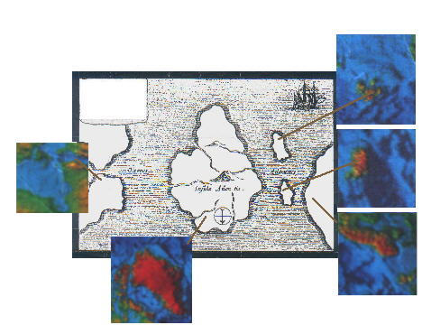
FIGURE 3: In 1665 Athanasasius published a map of the ancient continent in a work titled `Mundus Subterraneous'
A large work on Atlantis based upon material Kircher had available
to him from within the church which included the Timeus and Critias
The publication itself is about the structure of the Earth, volcanism, the myth of Atlantis and
his strict interpetation of the 'TIMEUS' and 'CRITIAS'
"Site of Atlantis, now beneath the sea, according to the beliefs of the Egyptians and the description of Plato".
In 1665 Athanasasius published a map of the ancient continent in a work titled `Mundus Subterraneous' - a large work on Atlantis based upon material Kircher had available to him from within the church which included the Timeus and Critias.
The map upon which it was based is popularly considered to have been from Egyptian copy saved (or 'taken' depending on how you look at it) from the burning of the Egyptian city of Alexandria by Julius Caesar and given to the Roman Church and Priesthood. Athanasius, an expert in the 17th Century in the interpretation of Egyptian Hieroglyphs was asked by the Pope of the Roman Catholic to interpret one particular particular obelisk with some difficult hieroglphics. In return for being able to translate the hieroglyphics on this particular obelisk - Athanasius received substantial funds towards his work and publications.
THE MAP AND THE BAFFIN BAY THEORY
The interpretive time of the Atlantean event is as sometime since the breakup of the Pangean super-continent and subsequently the basin is said to have developed from some 100 million years ago. This is the scientific description.
As we speculate upon the Basin as a site of a recent rather than ancient event we see a sudden (one day and one night)catastrophic event of a magnitude take place such that it involved the collapse of land into the sea, at the same time - in the far off Mediteranean.
We speculate the possibilities:
i) The microplate/fault boundry simply dropped suddenly and landslides about the coastlines allowed Atlantic waters to breach land and fill the hole. The raised sediment largely settled over towards America's while more filtered south towards the Mediteranean.
ii) The comet/asteroid theory! A heavenly body approaches from the Atlantic south of Greenland . Its direction of travel is to the north west and slams into the Baffin region causing the collapse of the microplate, the and of course, the ultimate flooding of all that is left, by the Atlantic Ocean and the raising of sediment. The raised rock & sediment largely settles towards America while sediment filtered south towards the Mediteranean. The impact of such a body would have to have been sufficient to cause earthquakes and land loss in the Mediteranean.
iii) Volcanic Trigger. Volcanic eruption triggers the faulting of the microplate following a series of prior eruptions and of flash flooding by glacial meltwaters and Lahars. Earthquakes resulting from the fault collapse breach mountain access to the ocean. Again, the combination of plate collapse and volcanics would have to have been sufficient to cause earthquakes and coastal land loss in the Mediteranean.
Any sinking of such a size would have raised enormous amounts of terrigeneous (Earth originating) sediment onto both North America and the Atlantic Ocean - potentially enough to have restricted light vessel travel out of the Mediteranean many miles to the South.
How much dirt would it take to create enough sediment to stop ancient mariners from exiting the Atlantic? The answer perhaps comes closer, if you can you start with a location and a representitive volume of Earth. In this case the location is Baffin Bay and the volume is the volume of the hole in the Earth that we call Baffin Basin and suppose it to have once been solid Earth (to just above sea level) at one time.
By the Baffin Bay Theory the catastrophe involved the collapsing, sinking and ultimate engulfing by the northern Atlantic of a chunk of land equal to the volume of Baffin Bay.
Many researchers have used this map to identify numerous possible locations, but no location about the globe bares as striking a similarity as the views of the northern polar region spanning Hudson Bay, Greenland, the islands of Iceland and Svalbard; and the Norwegian coastline.
The similarity becomes even more apparent when we understand the shallow continental shelf between Scandinavia and Britain is believed to have been above sea level 12,000 years ago forming a continuous coastline this is an essential part of Viatcheslav Koudriavtsev's Celtic Shelf hypothesis.
FIGURE 9: The two compared. The placement of two offshore islands on Kircher's map coincides with the position and linear distances between the two islands of Iceland and Svalbard and Greenlands Eastern coast. Hudson Bay (suggested here to have been as an ice bounded meltwater lake)is itself obvious on the other side of the map. Greenland takes the place of the larger portion of the island of Atlantis, with a starkly similar straight coastline being shared with the eastern coastline of Greenland.
How could such a frozen continent have supported a civilization some 12,000 years ago? Many would say that is a fair question to ask, and I would certainly be amongst them.
We may remind ourselves that 12,000 years ago the northern hemisphere was emerging out of what is referred to as the Pleistocene ice age (it had its ups & downs)and consider that it was warming and warmer for longer, about the southern and eastern coasts so persons from warmer southern area's of Europe, Africa or the America's colonised.
We find that Greenland with may well have spent some 70,000 years of the last 120,000 years in a temperate zone on the outskirts of a wandering polar circle - a result of orbital and axial variations and perhaps also `crustal displacement' and so, coastal area's of Greenland may well have been warmer and ice free more often and steadily than we might think( see Charles Hapgoods 'Theory of Crustal Displacement'. Crustal Displacement is an integral part of Rose and Rand Flem-Ath's Antarctic Hypothesis. Is this scientifically provable?
On it's own, this is not enough because no matter how cold or warm Greenland is or was; it is only half the size of the Atlantis described in the Timeus & Critias.
And that fact, makes everything so much more interesting!
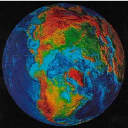
FIGURE 10: Source Scientific American May, 1995 . This provides us with an excellent view of both land and ocean topography. Permission to reproduce not yet sought.
FIGURE 11: This image demonstrates the perspective of the Baffin Bay Theory pointing to where modern landforms might relate to the map of Athanasius Kircher. To be taken into account when comparing the two are many factors. That the sinking of Atlantis we are told by Plato raised a lot of sediment, that the average global sealevel has risen by between 100 & 150 metres over that of 11,500 years ago, that the continental masses involved here (the Canadian Shelf, Hudson Bay, Northern Europe & Greenland) are affected by shifting weights of ice (the pole and the distribution and location of ice shifts and may do this over a 5,000 year span separated by ~35,000 year periods of stability) and, that local coastal relief and slope determine the change of form of coast from encroachment of water (ie flat lying coastland is heavily occupied by water).
We raise an ancient plain from beneath these waters of Baffin Bay and set upon it the acropolis of Atlantis amidst glaciers and forested mountains abounding with rivers which flow seasonally down to the plain below.
Is it just coincidence that the size of the Atlantean plain as described by Plato makes a comfortable fit within the surface projection of Baffin Basin?
Most of the population live upon a the massive plain which lay just some small amount above sea level. Watered by glacial meltwater rivers in summer, by rain in winter, protected from chilling northern winds by precipitous mountains to the north.
That two seasons are told by Plato to dominate the climate is a clue to this location and is here speculated to be a consequence of the island continent's position in the high latitudes. Their civilisation is said to also have had empire over and access by sea to the European continent and the Mediterranean.
There are many supporting statements to the Baffin Bay Theory contained within the texts of the Timeus and the Critias, in fact one thing that can be said about this theory is that it seeks to not change a single word of these writings!
THE MYTH
According to Plato the Atlanteans descended from one of several `Gods' who divided the Earth amongst them. One in particular male God had choosen a region we know today as Atlantis. A Brother and a Sister chose to inhabit the Meditteranean. Plato does not tell us of other Gods and their allotments of the Earth.
In Atlantis the civilisation that burst forward are said to have thrived for many tens of thousands of years in an Acropolis centered around an island dedicated to the founding father - the originating 'God". The greater Acropolis of Atlantis was settled upon a large plain surrounded with forested mountains and watered by mountain rivers in summer season and more by rain and thermal waters in winter season. Numerous villages were amongst the mountains.
A portion of Atlantis consisted of a large rectangular plain with mountains in all directions with one side being coastal mountains in nature. Plato tells us that the outer ring edge of the acropolis of Atlantis(which was situated upon the plain) was a mere 50 stades (5 miles) from ocean via a rather large channel sliced through land to the coast for military and merchant vessels to reach the ocean.
The text from Plato on these dimensions reads "...measured 3000 stades [340 miles] in length. And at its midpoint 2000 stades in breadth from the coast...'.
The text does not say that the coastal edge was mountainous. It does say that the plain was 'surrounded by mountains' usually taken to indicate mountain ranges could be seen in all directions about the rectangular plain. Plato records that the plain was protected from the north winds telling us that the mountains to the North were high and numerous. We are told the plain was naturally rectangular in shape measuring 3000 stades x 2000 stades ( 340 x 270 miles) which matches the dimensions of the Baffin Basin sinkhole. We are also told the plain itself "faced south".
The Baffin Bay/Greenland theory suggets that they were being beset (beginning sometime 13,000 BC) with a cooling climate as the northern polar point departed from European shores and moved over a five thousand year period (up to 8,000 BC) to its current location where it has been ever since. Faced with this problem the Atlanteans had expanded their empire into the Meditteranean regions of modern day Spain, Portugal, Morroco and Libya.
With the environmental situation becoming more difficult they attempted to completely overtake the Mediterranean in a single ill-fated naval campaign driven back by a pre-historic race of Athenian Greeks.
Shortly after the devastation and sinking of Atlantis occurs - as a truly catastrophic event involving the collapse of the great plain of Atlantis into a subterranean basin of immense proportions ... the Great Plain of Atlantis into the depths of Baffin Bay and raising a volumnous amount of sediment, silt and shale which spread as far south as the entrance to the Mediterranean and as far north as the shores of Canada and the Hudson Bay.
Such an event that would likely cause a jump in global air and ocean temperatures and caused numerous climate changes in the Northern Arctic Region. That such an increase occured at the end of the last ice age is attested to by scientific research. The jump was 20 degrees Celcius and settled down to a general increase of just 2-3 degrees after a geological short time. The mechanism for the end of the last ice age has remained hotly debated and not properly understood by science.
Was it a massive discharge in sediment from the collapse and sinking of the great plain of Atlantis that was the mechanism behind the jump in Global temperture ending the last ice age?.
The ultimate fate of these people was complete destruction of their homeland in a single day and night of Earthquakes and flood which entirely sunk beneath ocean waters raising enough sediment to prevent people travelling from the Mediteranean into the Atlantic some considerable distance away. And this happened sometime around 9,500 BC - several thousand years earlier than our earlist knowledge of the ancient Egyptian culture.
i]The plain was naturally rectangular in shape measuring 3000 stades x 2000 stades ( 340 x 270 miles) which matches closely the dimensions of the Baffin Basin sinkhole.
ii] Note the natural rectangular form of Baffin Bays Greenland and Baffin Island coasts around the sinkhole. These coastlines would form the long edges of the Atlantean plain.
iii] This being the case, we see any plain would be south facing with Baffin Island forming a southern group of coastal mountains.
iv] The coastal mountains were only a small[ish] group as it was a mere 5 miles between the acropolis of Atlantis indicating a range of just 5 miles in width.
v] To the north we expect to see larger and more numerous mountains protecting us from the North Winds (presumably cold if we need protection from them). From a viewpoint on the plain we see to the North the massive hulk of Greenlands mountains rising `precipitously` above us to the north protecting us from 'the north winds'.
vi] Looking to the short sides we currently see mountains to one direction (the Queen Elizabeth!?Island) but not to the other. To the other end we see an ocean inlet not a particularly wide inlet perhaps but not a mountain to be seen. This is important because it may give another clue to the process by which Atlantis met its end. The catastrophe included severe earthquake felt all the way to Greece. The great plain of Atlantis was barely above Sea level and we have an ocean inlet. Did this part of Atlantis create an inlet for the artic ocean during a severe earthquake?
OPEN CONFLICT: At least 11 DIFFERENT LOCATIONS have been proposed for Atlantis. Several location theories change aspects of the Timeus & Critias to suit their location aspects of size of the Atlantean mainland and/or the date of it's final destruction.
A major aspect of this Hudson Bay/Baffin Bay/Greenland theory is in justification of removing the location of the strait under discussion in Plato's text from the exit point of the Meditteranean to the entry of the Hudson Bay.
The reader may be well aware Atlantis has been placed in many locations. It has been placed in the mid-Atlantic , the Antarctic, the Mediterranean, the Black Sea (Sea of Maramar), Bermuda/Bahama's, South China Sea, the North Sea Celtic shelf, the Andes and others.
All but three (3) of these theories alter at least one, often two or even three crucial aspects of the description of the location of Atlantis as given to us in the Timeus, to justify their choice of location. Taken to assume that Solon or Plato or indeed both, made error(s) in describing details of the Legend as retold from Egypts records and so crucial changes as I have said, in the interpretive size of the island and the date of it's destruction can be justified.
Changing and reinterpreting what was described in the Timeus & Critias allows us to do things such as choose locations anywhere inside or outside the Mediteranean, make it a different size and change the chronological date of destruction.
Reasons for the change in the first case concerns where we locate the Pillars of Heracles either at Gibraltar or at the strait before the entrance to the Black Sea. For changes in size and date mathmatical error is the proclaimed remedy as the Egyptian figure for 100 is similar to that for 1,000. If a mistake is assumed by Solon or Platoin the interpretation of Egyptian numerals , the results are a more recent date for the sinking of Atlantis and the dimensions of the island can be made to be at least ten times smaller.
The island of Thera theory places Atlantis as a small island some 76 sq.km in area - the remanents of an island devastated by volcanic action around 1600 BC. This island is located inside the Mediteranean!.
One location theory places Atlantis beneath the weight of the great southern ice cap of Antarctica. Some 12,000 years ago a large portion of the Antarctic continent is said to have been outside the polar circle. This is when, we are told; a massive geological event said to occur regularly on a time scale of every thirty to fifty thousand years and taking some five thousand years to complete, occured.
This event is an `Earth slippage' a supposed `sliding' of the Earth's rocky mantle over the lower molten, Asthenosphere occurring in response to shifting of the load of polar ice caps from a land based ice cap to an ocean based ice cap, and vice versa, causing an imbalance (torque)of weight about the globe. The possibilty of this occurance was even pondered by Albert Einstein. Based upon contemporary studies of glacial advances over the last 120,000 years and with all its intriguing points the basic trouble with this theory is it locates Atlantis totally on the other side of the world which departs considerably from the description of the location of Atlantis as being outside and opposite the exit of the Mediteranean (not outside, turn left & travel half the globe).
Plato' dscription et al is embodied in the mid-Atlantic theory and places Atlantis in the middle of the Atlantic Ocean outside and opposite the Pillars of Hercles and is the one theory that doesn't change a word of the legend passed down to us, adhering faithfully to every detail in the Timeus ( and the Critias ) in setting the scene of the destruction as one of a land mass of large size around 9600 BC ( 11,600 years ago) and locates it outside and opposite the exit of the Mediterranean. The strait forming the exit of the Mediteranean was known to the ancient Greeks as the Pillars of Heracles and to the ancient Romans as the Pillar of Hercules ( the Greek and Roman names are equivalent referring to the same legendary man ie of great strength ).
Every theory though has its critics, and the mid-Atlantic location is heavily discounted by oceanographers, marine scientists, geologists and the like who are adamant - if a legendary island of large size called Atlantis ever did exist; it did not exist in the mid-Atlantic in 9,600 BC or any time before that. Being the site of a spreading rift stretching north and south of the Atlantic will have been geologically impossible for a continent to have existed there. Which is exactly why Atlantis theorists go looking for Atlantis in other regions.
The removal of the location from the Mediteranean strait reference point is often done without justification by many location theorists - this Hudson Bay/Baffin Bay/Geenland theory offers justification achieved without changing a single word of the texts - but merely the intent within just a few words spoken by an elderly Egyptian priest to a Greek whose people had very little knowledge of what lay beyond the exit of the Meditteranean.
THE PHOENICIANS c. 2000-400 BC
The Phoenician people emerged into history from Mesopotamia around 2000 BC. By 1400 BC they were living in the area of modern day coastal Lebanon and Syria. Unlike others of the Mediteranean these people developed their sea faring skills to become the dominant seafarers in the region. Ultimately they established colonies over the breadth of the Mediterranean and east to Cadiz on the northern (Spanish) side of the Pillars of Heracles and opposite on the southern side beneath the Atlas Mountains of North Africa.
In the history of the Mediterranean and particularly the Ancient Greek people of the time of Solon (almost) no-one had knowledge of what lay beyond the exit of the Mediterranean. Mediteranean cultures were able to meet their relative needs from within the Mediterranean and were put off venturing beyond the strait by their belief that you would drop off the edge of the world should you travel out far beyond the exit of the Mediterranean. The known world was a flat disc to the people of the Mediterranean. Venturing too far out into the Atlantic beyond the Pillars of Hercules meant you would ultimately fall off the edge of this disc to your certain death. A belief which persisted for two thousand more years and was prevalent even up to Christopher Columbus' discovery of America.
In the time of Solon and of Plato, the only people who were brave enough to leave the Mediterranean were Phoenician traders who ventured out beyond the exit of the Mediteranean in search of new resources and trade opportunities. To protect the knowledge of the resources they found beyond the straits they built on the fears of the other peoples with tales of hellish and horrifying sea monsters (large enough to swallow whole ships) of angry gods and deathly winds.
Not keen themselves to venture out into the Atlantic the Phoenicians kept to coastlines in their travels. Their coastal navigating skills and knowledge of the coasts beyond the strait meant they ultimately succeeding in circumnavigating all of the African continent in a journey said to have taken them 3 years. They did also ventured north along the coast outside the straits to near the south of France. For unknown reasons Phoenician seafarers departed from the safety of coastal navigating and at least once, made sail to the shores of Britain.
The point to be made here is that not even the greatest early seafarers of the Mediteranean had any knowledge of what existed outside the Mediteranean and the shores of Britain. Neither Solon (c. 600 BC) nor Plato (c. 350 BC) knew as much as this. They had no knowledge of anything beyond the straits except the edge of the world and certainly they had no knowledge of places such as Greenland, the Hudson Bay and the America's existing out there. The only straits that Mediterranean people had knowledge of were the ext point of the Mediterranean and some smaller straits in the eastern lands of the Mediterranean.
The only people who may have had an inkling of at least the possibility of such lands as these, may have been Egyptian priests with access to the oldest of Egyptian sacred records and knowledge, the oldest of which is described as dating back to 9,600 BC. If the Egyptian priests were describing a strait and a set of pillars anywhere beyond the Mediterranean Solon would have not had any knowledge of where they might be and would have immediately taken them to mean the greatest known strait of the time ?the exit of the Mediterranean. After all, there was nothing but horrifying monsters, the edge of the world to fall off - and certain death out there.
A MISUNDERSTANDING
We learnt earlier that Atlantis could not have existed in the Atlantic according to contemporary oceanographic and geological science. If we continue to cling to the belief Atlantis existed then we conclude there has somehow and at some point been a mistake made in describing the location of Atlantis - how might this have happened? And how can we be so bold as to declare Solon to have made this mistake? is there any justification for considering the Egyptian priest(s) were speaking of another strait?
We recall from the Timeus the names of places and gods were being related to Solon in their Egyptian form and that Solon undertook then and later to ascertain the Greek `equivalent' of the names of places and gods as given to him in Egyptian by the priest(s) for retelling back at home in Greece. And from our knowledge of Mediteranean history gained earlier, we know neither Solon or Plato had any knowledge of lands beyond the Pillars of Herecles so if the Egyptian priest(s) in discussing the location of the island of Atlantis as being outside and opposite a certain strait; ie the Strait of `Egyptian Name Goes Here' - were speaking of any other strait outside any other one than at the exit of the Mediteranean, Solon would have been totally oblivious and unclear as to the strait being discussed and would of had to interpret this strait to be the only strait familiar to him and not would have interpreted the Egyptian title he was given to agree with this.
An answer appears in the Timeus - it didn't require the change of a single word of the Timeus - but did question how we should interpret just a mere few words spoken by the elder Egyptian priest when speaking of the straits opposite Atlantis. They were "... as you say..." [Solon]. We can read this in two ways. Either the elderly Egyptian priest is agreeing with Solons belief that the Strait being discussed is the Straits of Herecles or the priest - over a discourse that was continuing from earlier and if any strait other than the Pillars of Herecles was being discussed - may have been tiring of explaining to a steadfast Greek and the relationship of another strait with the island of Atlantis, one of which Solon had no knowledge or concept of.
On its own, this would not be sufficient to cast doubt on the correctness of Solons' description of the location of Atlantis. But there is more reason to believe that the priest was talking about another strait when but a few sentences later he says " for the sea within the strait we were talking about is like a lake with a narrow entrance; the outer ocean is the real ocean and the land which entirely surrounds it is properly termed continent". Here, moments later the priest doesn't simply say in affirmation of Solons belief `... Yes, outside and opposite the Mediteranean which is within the `Pillars of Herecles is like ... etc'.
Surely the Egyptian priest would have been knowledgeable enough to know the Greek word for the sea within the Pillars of Herecles ie the Mediteranean ? In fact he probably knew enough about Greek language to call the `Pillars of Herecles' the `Pillars of Herecles' which would be like talking about the Mediterranean without referring to it by name. Why not just say `... for the Mediteranean within the Pillars of Herecles, is like a lake with a narrow entrance... etc '. In not doing so, the priest it seems appears to be avoiding confirming these straits as being the Pillars of Herecles preferring to say `the straits we were talking about' and by not referring to the sea inside the straits as the Mediteranean.
In casting doubt upon the name and location of the straits and the sea being discussed by the Egyptian Priest(s) we are free to roam the globe for another strait and a sea `... like a lake with a narrow entrance and a real ocean outside' and a land known as Atlantis which was `outside and opposite' these other Straits.
This article centres the strait being discussed as being upon the entrance to the Hudson Bay - outside and opposite is Baffin Island, Baffin Bay and Greenland.
Without a doubt Athanasius used the Timeus & Critias in constructing his book and that he used them in constructing the map he has offered to us in his Mundus Subterraneous. However some things about this map point to it being a reproduction of an actual ancient map of either Greek or Egyptian origin. `The main title label on his map is oddly placed when one considers there is obviously sufficient room just to the right over empty ocean and this would not obscure the part of the coastline of Africa that it obscures. Did he simply not consider the western coast of Africa worth portraying?. Did Kircher simply have no design sense or did he intentionally obscure part of an older map? And if so, what reason was there for obscuring this singular region?.
Whatever we should decide on this issue we should hold perhaps some healthy doubt that Kircher's map being a copy of an actual ancient map though regardless of wether it is or not, this map is at least faithful portrayal of Plato's description of Atlantis. It is as an island the size of Libya & Asia ( as they were known c. 600 BC ) existing directly outside and opposite the exit of the Mediterranean.
THE ROAMING ICE CAP
Neither the polar circle nor the polar cap stay in one place over the millenia. Over periods hundreds and thousands of years various differential portions of each hemisphere have been ice covered (and southern) become covered in ice at one time or another. One reason for this, is that over thousands (and millions) of years the position of the north pole wanders about in about a circle completing a cycle about every 75 thousand years plus.
And this, because the Earth rotates on its axis more like a slightly off-centre spinning-top as it rotates, the degree of the tilt varying between 22 and 24.8 degrees. A second (astronomical) factor is that the elliptical form of our orbit rotates about the sun. And another factor, what is called the eccentricity of our orbit - the amount by which we vary from a perfect circle - changes over large periods of time. All these factors and perhaps crustal slippage (Charles Hapgoods crustal displacement theory) result in a cycle of glaciation of varying degrees and extent and importantly to us, variation in the location of the central ice flow in the north and south polar regions.
Greenland judging by Charles Hapgoods research and contemporary research, has spent some 70,000 of the last 120,0000 years in the outer temperate zone on the edge of a wandering polar circle glaciating various parts of the north polar continents at different times. The period 120,000 - 80,000 BC was a time of Greenland being in a temperate zones on the outside or on the edge of the polar circle. 120,000 BC to 80,000 BC saw the northern pole situated in theYukon near the border today, with Alaska. Around 50,000 BC the icecap had moved to a location centered on Hudson Bay. The entire Hudson Bay & south towards and beyond the Great Lakes, became covered in ice ?and so the stuation remained for some 25,000 years and is referred to as the Laurentide Ice Sheet.
This period 50,000 - 25,000 BC is postulated to have been the time of the original flourishing Atlantean empire and a period when Greenland can be stated to be in a temperate zone - although the standard scientific model attempts to present the situation as one of a frozen polar region. It should be noted that it has been difficult for geologists and other scientist to completely map the movements of the poles and the existence, nature and extent of various ice movements at any time and controversy does exist over many of the proposed flows. This is also the time(s) of the heavily debated ocean ice Barents and Kara ice sheets, which also calls to question the extent of polar sea and land ice in the northern Atlantic (yes, Greenland is in the Atlantic Ocean, an important prerequisite for any Atlantis location theory).
While one would expect permanent ice and glaciation in mountainous Greenland, an alluvial plain situated below the snow line (and barely above sealevel) in times when Greenland existed in a temperate region would quite possibly have been ice free and in a similar situation to many Alpine plains about the world. The Canterbury Plains of New Zealand is a land where mountain and glaciation outwash has created quite a fertile plain beneath the eastern side of the Southern Alpine Range. New Zealand exists in a similar situation to Greenland ie New Zealand is located just outside the southern polar circle and has a temperate climate and apart from its highest mountains peaks and the Southern Alps chain it is free of permanent ice and snow. We need also to emphasise that the plain of Atlantis was to have been surrounded by high mountains all about land which obviously implies the plain is likely to be have been beneath the prevalent ice and snow lines.
Around 30,000 BC it seems the northern polar point may have begun to deviate away from the Hudson Bay location to the Scandinavian Coastline perhap following a curved path over the Barents and Kara Seas. in a process which Charles Hapgood suggests to us, takes some 5,000 years to complete. When the pole began to leave the Hudson Bay region the land beneath and about Hudson Bay began rising in response to the load of the icecap being shifted from upon it. This process is known as isostatic uplifting.
During the time span 15,000-11,000 BC the northern polar cap is departing the Scandinavian shores andapproaching its current position - to north of Greenland ?freeing Europe from the grips of a severe ice-age and placing Greenland firmly within the polar circle and depriving it of any possibility of a temperate climate. It will have certainly ?as evidenced today ?become a completely frozen land mass.
Prior to the end of the last glaciation , ocean levels are accepted to have been a mean amount of 100 metres lower than present. With more water tied up in ice then than now, geologists are lead to believe sea levels to have been lower than now by between 50 and 165 metres in the time period 50,000 to 12,000 years ago. In 13,000 BC a time just prior to the destruction of Atlantis in 10,000 BC, world ocean levels were a mean of 130 metres lower than now with estimates varying between 75 and 160 metres.
RISING OCEAN LEVELS
12,000 years ago more of the planetary water was tied up in land ice in particular upon Northern Europe. The water for land ice must come from somewhere and so this meant lower mean sea levels prior 10,000 BC. In combination with processes known as Glacial isostatic depression & isostatic uplifting events (regularly glaciated land rises or falls according to the weight of the ice upon it)and with local factors such as the slope a section of coastal land might have had 12,000 years ago just prior to a major catastrophic event well, ... ... the Hudson Bay - Baffin island - Greenland - Scandinavia - coastlines all looked different in 10,000 BC.
For example, the Celtic Shelf ( the submerged continental shelf platform between England and Scandinavia) is a probable site of isostatic uplifting suggesting to many that this area would have been above the mean sea level and formed part of a continuous northern European & Scandinavian coastline.
This is important in realising the unbroken coast which curves into the righthand side of Athansius Kirchers could possibly be the northern European & Scandinavian coastline BEFORE 9,500 BC.
Of course, it is also stated by Plato that the destruction of Atlantis involved the raising of substantial amounts of sediment sufficient (according to the Egyptian priests) to prevent travel out of the Mediterranean into the Atlantic for thousands of years. And this gross raising of sediment should be taken into account.
A theory which places Atlantis in Greenland will require evidence of substantial sediment deposition. This is clearly seen in the islands north of Canada up to Greenland which are with few exceptions low lying deposits of shale, shingle and sediment.
This also includes Baffin Island which if stripped of its sediment would be little more than a handful of small mountain islands. Stripped of sediment deposition the land forms which cloud the region between Greenland and the North American continent would reduce to little more than a few rock or mountain islands in a largely empty ocean region. It is important perhaps here to give at least passing thought to the volume of sediment that would have been created by the sinking and excavation of a hole the size of Baffin Bay.
The TIMEUS on the Web
The CRITIAS on the Web
GREENLAND GUIDE
GEOLOGY OF DENMARK & GREENLAND
POLAR BATHYMETRY
ATHANASIUS KIRCHER RENAISSANCE MAN
OFFSHORE LABRADOR-BAFFIN BAY-WEST GREENLAND PALAEOCENE-EOCENE STRATIGRAPHY
LATE QUATERNARY STRATIGRAPHY, CHRONOLOGY, AND DEPOSITIONAL PROCESSES ON THE SLOPE OF S.E. BAFFIN ISLAND, DETRITAL CARBONATE AND HEINRICH EVENTS
STRATIGRAPHY OF SOUTHEAST BAFFIN ISLAND
DRILL HOLES SOUTHEAST BAFFIN ISLAND
ANCIENT BIG GAME HUNTING
Taylor, T. The Commentaries of Proclus on the Timeus of Plato, (Five Books in Two Volumes) Kessinger Books, Kila [ISBN 1-56459-349-5].
PLATO: The TIMAEUS and THE CRITIAS, Thomas Taylor Translation, Bollingen Series, Pantheon Books, Washington 1944.
http://www.otsf.org/storyjourney.htm
Thank you for visiting my page at Angelfire.
Please come back and visit again!
![]()
![]()
![]()
Over centuries and even millenia vast numbers of people have studied Atlantis and
![]()
![]()

FIGURE 1: The greek philosopher Plato(429-347 BC) gives us record of the
![]()
![]()

FIGURE 2: In the seventeenth century Athanasius Kircher was a highly patronised Jesuit priest,
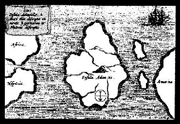
FIGURE 4: The label on his map published in 'Mundus Subterraneous' reads
Kirchers map is labelled representing Atlantis in the Mid-Atlantic between Western Europe and the east coast of North America. On the map the two islands which grouped together are called Atlanticus ( ie lesser Atlantis). The orientation depicts a `south is up' view of the world (north is still indicated by Kirchers compass) a view of the world held by ancient Egyptians as south is the direction from which the Nile river flows. The main label obscures a part of the W. African coast. - was this deliberate orperhaps the original was damaged here - or perhaps it had a section that looked nothing like the African Coast.
![]()

FIGURE 5: Do we discount Kirchers map because modern science tells us that the Mid-Atlantic ridge has never been above water? No. If athanasius had a map in front of him it did not have latin labels but it still may have come from ancient Egypt, Indus or even the Celtic lands. The original map would have looked more like this. The Atlantis Beneath Baffin Bay theory compares this map (without labels)to the contemporary arctic.
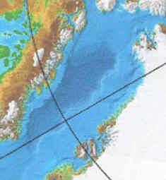
FIGURE 6: The Baffin Bay and the rift that lays beneath it. It is considered in mainstream science to be an aeon old spreading rift formed from gradual continental drift. Did it instead, split apart just 11,500 years ago?

![]()
![]()

FIGURE 12: The acropolis of Atlantis was of the form of coencentric rings of land and water and a central island dedicated to the founding figure of the land which was set amidst a massively larger plain of flat land which was barely above sea level. The Acropolis itself, then was also barely above sea level (an important reference in Plato's works which gives clue to the process of the calamity which struck Atlantis).
SOURCE: http://orbita.starmedia.com/~caminhos_de_luz/
Compare for yourself how well this described situation fits the region of Baffin Bay ... if ... you visualise a plain exsisting there instead of a lot of water. Note:
![]()
![]()
![]()
![]()
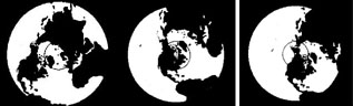
Figure 13: Source: Nexus Magazine April-May 1998 pp 33; Rand Flem-Ath. Permission to reproduce not yet sought. Movement of the Polar Circle over the last 120,000 years. i) 120,000 to 80,000 years ago centred on the Yukon. ii) 80,000 to 75,000 years ago Geenland ice. iii) 50,000 years ago the pole is centred on the Hudson Bay and Greenland in a temperate zone. Therafter the pole moved to a position on the Scandinvian Coast, still leaving Greenland in a largely temperate zone. The pole moved to its current position north of Greenland between 17,000 and 12,000 years ago (or between 15,000 BC & 10,000 BC.
Oddly pole positions stay relatively stable for tens of thousands of years, shifting relatively suddenly in transition to a new location in a time period spanning some 4 to 5,000 years.
![]()
LINKS
http://www.activemind.com/Mysterious/Topics/Atlantis/timaeus_page2.html
http://www.activemind.com/Mysterious/Topics/Atlantis/critias_page1.html
http://www.greenland-guide.dk/
http://www.geus.dk/
MEM/THE GEOLOGICAL SURVEY OF DENMARK AND GREENLAND, GEUS.
http://www.mem.dk/organisation/ukorg/UKDGGU.HTM
http://www.zenith.ngdc.noaa.gov/mgg/bathymetry/arctic/provisionalmap.html
(This is a 1.5Mb file and well worth the download)
http://www.companymagazine.org/v192/renaissance.htm
http://www.bujakmudge.com/reports/NWAM/figures.html
http://www.erudit.org/erudit/gpq/v52n01/andrews/andrews.html
http://www.erudit.org/erudit/gpq/v52n01/andrews/fig01.jpg
http://www.erudit.org/erudit/gpq/v52n01/andrews/fig02.jpg
http://www.mnsu.edu/emuseum/prehistory/hunters/index.shtml
![]()
![]()
