WELLESLEY - MILE 11.8
After leaving Natick on the "Bay Path" on Route 135, one leaves Middlesex County and enters Norfolk County and the Town of Wellesley. The original name for the area that became Wellesley was "Contentment". The area was purchased from the Indians in the 1630's and was originally part of Needham. In 1774, the area became a "west parish" of Natick and in 1778 it became the separate incorporated Town of West Needham. Finally, in 1881, the town reincorporated as the Town of Wellesley. The name was chosen as a tribute to one of the early settlers of the town. In 1763, Samual Welles set-up his homestead in Wellesley. The Welles House was at the corner of Washington Street and Central Street (Route 135). In 1881, his descendent Horatio Hollis Hunnewell bought all of the original homestead and then donated the entire estate to the new Town of Wellesley.
The course in Wellesley follows Central Street (Rt. 135) and coincides with the Old Central Turnpike. At mile 12.3, the first and most prominent landmark is Wellesley College , which is located on the right. This prominent college for women is known today by every Boston Marathon runner as the area with the loudest and most heartwarming cheers and screams. Many runners in fact refer to the Wellesley College experience as a "real rush" of energy. The college was founded in 1870 as a female seminary and the name was actually chosen before the town name was determined a decade later. This institution has approximately 500 acres in the center of Wellesley. It's gothic and modern structures spread across the rolling campus hills and around Lake Waban. The lake was named in the 1860's for the Natick Indian that helped Rev. John Eliot. Waban was originally a Concord Indian that died in 1674 at the age of 70. Lake Waban was previously known as Saw Mill Pond, which was related to the area's former use. The center piece of the campus is the Houghton Memorial Chapel, a gothic revival edifice built in the 1890's. Also of note is the Durant House (the President's House), an early Victorian mansion built around 1860.
Following the college, Central Street leads into Wellesley Center where Rt. 135 intersects with Route 16. This is the half way point of the marathon (13.1). The Center, a thriving business district with numerous small specialty stores, was mostly built up in the 20th century. The dominant brick Colonial Revival Wellesley Congregational Church (1922) is also on the right. This congregation was founded in 1798. Across the street from this church is a small park that is dedicated to Katherine Lee Bates (1871-1929). This Wellesley College graduate and resident of Wellesley in her later years wrote the song: "America the Beautiful".
As one proceeds through the Center, the trail leaves the "Bay Path" and proceeds onto Washington St. (Rt. 16). On the left is the main Town Libary and the magnificant Wellesley Town Hall, perched on the hill in the middle of Hunnewell Park. At the base of this park is a Vietnam War Memorial. The town hall was originally built as a library in 1881 with a 1883 town-hall addition. This magnificant Romanesquese Richardsonian Revival masonry building, has two distinctive turrets to give the building a castle-like appearance. The surrounding park was designed by Frederick Law Olmsted, the designer of the U.S. Capitol grounds, the Emerald Necklance in Boston, and New York's Central Park. The entire Town Hall site, as well as the adjacent town libary site (1894), is located in the National Register of Historic Places. Across the street from the Town Hall is the new Wellesley Free Library. This beautiful modern brick structure opened on June 1, 2003 and is now the newest public building on the Marathon course. Washington Street (Route 16) then follows the route of the railroad lines into Wellesley Hills.

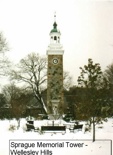
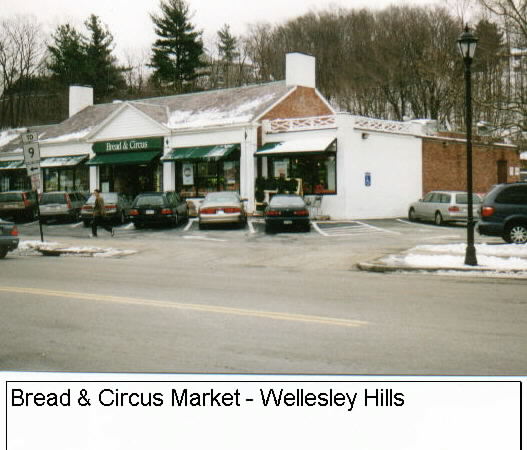
As one enters Wellesley Hills, there is the Isaac Sprague (1860-1934) Memorial Clock Tower, which was constructed to resemble the famous Venetian Campanile in Venice,Italy, is within the Wellesley Hills Common. The tower was presented to Wellesley Hills to honor a local resident when Wellesley Hills was still known as Grantville. Wellesley Hills was established as Grantville in 1851 after Moses Grant donated the bell for the Congregational Church. In the center of Wellesley Hills, one passes over the Route 9 bridge, which was the original Boston-Worcester Turnpike. This Rt. 9 underpass and bridge was built in 1932. Immediately following Rt.9 and set back a little to the left is the Dadmun-MacNamara House (1824). This house was originally the toll-keeper's house for the turnpike and now houses the Wellesley Historical Society museum and offices. The Wellesley Hills Congregational Church follows on the left. This congregation was organized in 1847 and the current building was built in 1901. The Wellesley Hills business district includes the Whole Foods Market (formerly the Bread and Circus market), which is the largest national chain of natural, organic and whole foods.

 Proceeding on down Washington Street, one begins a descent down Maugus Hill, a 300 foot elevation hill named for one of the original Wellesley Indian Chiefs that was converted by John Eliot. On both sides of Maugus Hill there are numerous architecturally prominent Victorian residences. Near the base of the hill to the left (at the end of Glen Street) is the area known as Wellesley Farms. A Henry Hobbs Richardson designed train station is set back about a quarter mile. Frederick Law Olmsted also collaborated with Richardson by designing the landscape for this project. It is one of the few places in whic the collaboration of these two famous designers is still extant.
While proceeding down the hill, Wellesley's Crosstown Trail intersects with Washington Street. This town-managed walking path traverses almost the entire center of the town. Near the bottom of the hill is the St. John the Evangelist Roman Catholic Church. This prominent white painted and wooden church was constructed in 1900.
At the bottom of Maugus Hill the Charles River crosses under Washington Street (Wellesley) before it becomes Washington St. in Newton Lower Falls. The current Washington St. bridge replaces one that has been there since 1704, when it was known as Pratt's Bridge. This is the only place where the marathon trail comes in direct contact with the Charles River, even though the source of the Charles is in Hopkinton at Echo Lake and much of the marathon trail is in the valley of the Charles. The Indian name for the Charles was the Quinobeguin, which is translated appropriately as "meandering". Just before crossing the bridge set back on the right is a stone tablet which preserves the fact that President George Washington came ashore at that point in Wellesley in 1789.

 In the center of Wellesley Hills, one passes over the Route 9 bridge, which was the original Boston-Worcester Turnpike. This Rt. 9 underpass and bridge was built in 1932. Immediately following Rt.9 and set back a little to the left is the Dadmun-MacNamara House (1824). This house was originally the toll-keeper's house for the turnpike and now houses the Wellesley Historical Society museum and offices. The Wellesley Hills Congregational Church follows on the left. This congregation was organized in 1847 and the current building was built in 1901. The Wellesley Hills business district includes the Whole Foods Market (formerly the Bread and Circus market), which is the largest national chain of natural, organic and whole foods.
 Proceeding on down Washington Street, one begins a descent down Maugus Hill, a 300 foot elevation hill named for one of the original Wellesley Indian Chiefs that was converted by John Eliot. On both sides of Maugus Hill there are numerous architecturally prominent Victorian residences. Near the base of the hill to the left (at the end of Glen Street) is the area known as Wellesley Farms. A Henry Hobbs Richardson designed train station is set back about a quarter mile. Frederick Law Olmsted also collaborated with Richardson by designing the landscape for this project. It is one of the few places in whic the collaboration of these two famous designers is still extant.