1. Grant # _________, Mecklenburg NC. Issued to George Gerogor, being 100 acres on Hamby’s Branch. The warrant is for 200 acres “joining the lower end of the widow miller’s place & James Bradsaw line John Bigger line and down the river. ”The survey is for land that includes “Peter Reap and Jame Cortise improvements.” At the northwest corner of the plat, the beginning point of the survey is “by James Bratchey’s corner on the Dutch Waggon Road.” The southern most line and the lower half of the eastern most line of this tract adjoins the lands of John Leatsinger. The dotted open line adjoins lands of John Bigger. CC: Robert Bigger, John Finny.
2. Grant # 3347, Mecklenburg NC, ent. 18 Dec 1779, sur. 23 Apr 1783, iss. 2 Nov 1784. Issued to Peter Ciser, the warrant is for 100 acres on both sides of Rocky River “including his mill and mill dam being 50 acres on each side said river.” The survey ”includes his John Leatsinger’s improvemant.” The mouth of Hamby Run is located on this tract. From a water oak (on bank of river John Finney corner, running with 30 east 15 chs. to small p. o., north 51 west 14 chs. to hic. (John Finny, Peter Reap corner), (with Reap’s line) south 20 west 23 chs. to p. o., north 74 west 9 chs. (crossing Hamby’s Run) to small p. o. (Reap’s corner & John Bigger corner), (with Bigger’s line) south 8 west 9 chs. to w. o. (his corner) south 30 east 7 chs. to water oak (Bigger’s corner on bank of river), south 15 west 31 chs. (crossing said river) to small b. o., then to begin. CC: Andra Mathews, John Bigger.
3. Grant #3374, Mecklenburg NC, ent. 3 Mar 1779, sur. 23 Apr 1783, iss: 2 Nov 1784. Issued to John Finny, being 28 acres on the “Brushy Fork of Rocky River.” The tract adjoins John Leatsinger to the southwest and runs along James Cotise land to the west. CC: Robert Biggers, James Cortise.
4. Grant # 448, Cabarrus NC, ent. 3 Feb 1812, sur. 2 Aug 1813, iss. 24 Nov 1813. Isued to Francis Fonderburgh (Vanderburg), being 24 acres joining his own, Daniel Boger, and John Bost’s lines. Beginning at a hic. (his own corn Daniel Boger’s corner on the bank of the brushy fork of Hamby’s Branch) south 51 east 60 to po (Boger’s other corner), north 46 east 132 to stake (on John Bost’s line), (with his line) north 4 west 96 to pk (Bost’s corner on Philip Carriker’s line), (with his line) south 35 west 8 to bo (his own corner), (with his own line) fifty two east 96 (To his other corner), then (with his own line) to begin. CC: William Plott, Francis Fonderburgh.
5. Grant # 3700, Mecklenburg NC, ent. 27 Jun 1786, sur. 28 Apr 1787, iss. 26 Nov 1789. Issued to William Ross, the warrant for survey was for150 acres of land “joining John Finney, Peter Rape, John Finney’s entry on Brushy Fork, Jacob Casle, Andrew Mathews, John Ahsly, George & Andrew Carriger, and his own mill. The survey and issuance was for 97 acres joining John Ashley land to the east and John Finney land to the west and south. From a pine (John Ashly’s corner and with his open line) north 5 west 158 to stake, north 36 west 22 to p. o. (John Finny corner), (with Finny open line) south 44 west 162 to small p. o. (his own corner and Finny corner), (with his own line) south 30 west 50 to stake (by Finny corner), then (with his open line) to begin. CC: John Finny, James Bigger.
6. Grant # 3319, Mecklenburg NC, ent. 3 Mar 1779, sur. 23 Apr 1783, iss. 2 Nov 1784. Issued to John Finney, being 50 acres on the north side of Rocky River including his own improvements. From a hic. (Douglas Winchester’s line, running with his line) south 9 west 9 chs. to small p. o. (on river bank), (with various courses of river) north 84 west 15 chs. to small water oak, south 70 west 12 to water oak (John Leatsinger’s corner), (along his line) north 37 west 12 chs. to b. o., north 20 west 7 chs. to b. o. (said Leatsinger corner), north 8 east 8 chs. to stake, then to begin. CC: Andre Mathews, Robert Bigger.
Deed 2-38, Cabarrus NC, 19 Apr 1793, prv’d ___. Daniel Bean to William Ross Junior, being 50 acres. Wit: David McKinley, William Ross.
9A. Grant # 3885, Mecklenburg NC, ent. 14 Apr 1784, sur. 15 Nov 1790, iss. 28 Nov 1792. Issued to John Ashly, being 200 acres on Wetfot Branch adjoining George Caricker to the northwest and John Finny to the southwest. From b. o. south 55 west 34 to b. o. (George Carricker corner), (with his line) south 35 west 138 to pine not, south 47 east 78 to w. o. (John Finney corner), south 28 east 90 to stake (Jacob Keser’s line), (with his line) north 66 east 30 to pine (his corner), due east 36 to b. o., south 73 east 100 to big pine, north 25 east 100 p. o., then to begin. CC: Daniel Winchester, Andrew Mathias.
Deed 6-94, Cabarrus NC, 18 Sep 1804, prv’d Jul 1806. Elias Bost to John Bost his son, “a certain tract of land containing two hundred acres wheof 50 acres belong to the silver mine theron during the continuance of it & thereafterwards to revert to the said John Bost.” Now the stream running through the land is known as Whitford’s Branch. Wit: John Moyer, Daniel Bost.
7. Grant 3350, Mecklenburg NC, ent. ____, sur. 22 Apr 1783, iss. _____. Issued to Jacob Cagle, being “50 acres of land . . .including his John Ashly improvement. From a pine (on Duglas Winchester’s line, running with his line) south 67 east 17 chs. (crossing Wet Fot Branch, a branch of said river) to pine, north 14 east 17 chs. 50 lks. to pine, north 26 west 24 chs. to pine (on Andra Mathew’s line), (with said line) south 67 west 13 chs. to w. o., then to begin. CC: Andre Mathews, Robert Bigger.
Deed 4-71, Cabarrus NC, 3 Jun 1799, prv’d Jul 1801. George Christman to Elias Bost, being 50 acres on “Wetfoot Branch” adjoining Douglass Winchester to the south and Andrew Mathis to the northwest. Wit: Martin Beaver, Daniel Bost. Wit: German, Michael Christman.
Deed 6-93, Cabarrus NC, 3 Oct 1804, prv’d Jul 1806. Elias Bost to John Bost,, being 50 acres on “Whitford’s Branch” adjoining Douglass Winchester to the south and Andrew Mathews to the northwest. Wit: Martin Beaver, Daniel Bost.
8. Grant # 3441, Mecklenburg NC, ent. 22 Oct 1779, sur. 8 Apr 1783, iss. 2 Nov 1784. Issued to Douglas Winchester, being 94 acres located on both sides of Rocky River including his own improvement. From a w. o. north 15 east chs. to b. o., north 38 east 12 chs. to pine, north 9 east 15 chs. (crossing the river along John Finny entry) to b. o., south 67 east 17 chs. (along John Ashly entry) to hic., south 10 chs. (crossing the wagon road and said river) to b. o., south 50 east 7 to w. o. (by James Fleman line), south 67 west 19 chs. ti stake, south 23 east 20 chs. to stake, (crossing the road) to begin. CC: Daniel Winchester, Charls Dorton.
Deed 4-72, Cabarrus NC, 3 Jun 1799, prv’d Jul 1801, George Christman to Elias Bost. Being the fifty acre portion of this tract lying on the north side of Rocky River. Wit: German, Michael Christman.
9. Grant 530, Cabarrus NC, ent. 16 Nov 1819, sur. 20 Jun 1820, iss. 7 Dec 1820. Issued to John H. Bost and Daniel Boger, being 120 acres “for the use of the meeting house joining the heirs of John Hagler, dec’d. This is the land on which St. Martin’s Lutheran is built. From a forked syc. (on the river bank near John H. Bost’s) north 54 to hic. (corner of sd. Bost’s), north 14 east 84 to pine (corner of sd. Bost), north 26 west 116 to pine stump (Bost’s corner), east 32 small b. o. (Bost’s corner) south 73 east 74 to small hic. (corner of sd. Bost and John Hagler heirs), south 23 east 106 to b. o. (corner of sd. Hagler’s), south 31 west 160 to elm (on bank of river a corner of Hagler). CC: John Bigger, Leonard Haggler.
10. Grant # 3526, Mecklenburg NC, ent. 5 Jun 1779, sur.22 Apr 1785, iss. 7 Aug 1787. Issued to Henry Sides, being 100 acres adjoining John Hagler land and including his own improvements. From a stake south 31 west 96 to elm (on the river), (down river) south 58 east 132 to stake (John Hagler’s corner), (with his line) north 18 east 121 to p. o. (Hagler’s corner), (with Hagler line) north 40 east 96 to stake, then to begin. CC: Jacob Casel, John Neas.
11. Grant 35__, Mecklenburg NC, ent. ____ sur. 4 Mar 1786, iss. ______. Issued to Daniel Winchester, being 100 acres on the Meadow Branch of Rocky River adjoining Henry Sides land to the south. From a crooked p. o. north 13 west 58 to pine, south 55 west 70 to pine (by a branch), south 10 west 132 to pine, south 85 east 94 (near Henry Side’s open line) to big pine, north 19 east 34 to pine, north 45 east 92 to stake, then to begin. CC: John Ashley, Andrew Mathis.
12. Grant # 486, Cabarrus NC, ent. 20 Feb 1816, sur. 18 Oct 1817, iss. 28 Nov 1817. Issued to George Klutts, being 55 acres on Rocky River. Beginning at a small bj (Paul Furr’s and Francis Vandeburg’s corner) south 48 east 34 to a young wo (Paul Furr’s corner), (with his line) south 80 west 58 to b.o (on the side Furr’s corner) south 18 east 228 to ro (Furr’s corner), north 21 west 82 (with Hartsell’s line) to bo, north 26 west 28 (through Hartsell’s field) to pine, north 22 to stake, north 58 west 68 to po (Hartsell’s corner), north 98 to hickory (Hartsell’s corner), west 96 to pine, north 15 west 40 to po (John Bost’s corner on Vandeburg’s line, then (with his line) to begin. CC: Paul Furr, Leonard Hartsell.
13. Grant #3686, Mecklenburg NC, ent. 26 Nov 1780, sur. 9 Oct 178_, iss. 15 Dec 1786. Issued to Paul Furrow, being 100 acres on the waters of Dutch Buffalo adjoining John Hagler and Daniel Winchester at the southwest corner and Phillip Lyticker to the north. From a pine south 30 west 116 to small p. o. (on John Hagler’s line), (runs with his line) north 75 west 32 to small b. o. (Hagler’s and Winchester’s corner), north 18 west 228 to b. o. (on Phillip Lyticker line), east 32 to w. o. (on his own old line), then to begin. CC: John Hartsell, George Tucker.
14. Grant # 491, Cabarrus NC, ent. 11 Apr 1817, sur. 12 Mar 1818, iss. 4 Apr 1818. Isued to Paul Furrer, being 12 acres joining his own lands to the east and west and John Hagler heir’s land to the south. From a p. o. (corner of John Hagler’s heirs and his own, running with his own line) north seven east 100 to b. o. (on his own line & a corner of his own), (with his own line) south 30 west 102 to stake (corner of his own and on John Hagler heirs line), (with said line) south 75 east 38 to begin. CC: Henry Furrer, Leonard Furrer.
15. Grant #509, Cabarrus NC, ent. 21 Mar 1819, sur. 10 May 1819, iss. 6 Feb 1819. Issued to Leonard, Jacob, and Charles Hagler, being 50 acres joining the lands Tobias Klutts, Paul Furr, Leonard Hartsell, and their own lands. Shaded in red, this tract snakes around taking in vacant lands surrounding tracts granted or earlier purchased by John Hagler. From a p. o. & dead pine (their own old corner) north 74 west 110 to pine (Leonard Hartsell’s corner), (with his line) south 55 west 70 to pine (his other corner), (with his other line) due south 132 to hic. & dead pine (Hartsell’s other corner), (with his other line) south 86 east 108 to pine (Hartsell’s and their own old corner), (with his and their old line) north 20 east 56 to dead pine (in Hartsell’s field, his and their own corner), (with his and their own line) north 45 east 54 to hic. (their old corner passing Hartsell’s corner 8 poles), (with theirs and Paul Furr’s line south 75 east 160 to stake (in Paul Furr’s line, passing their own p. o. corner 46 poles), (with Paul Furr’s line) south 92 to stake, north 45 west 60 to pine (their own old corner), (with their own line) north 10 east 40 to b. o. (their own corner), south 74 west 8 to p. o. (their old corner), north 20 west 18 to p. o. (their own land), north 75 west 114 to (another) stake, south 30 west 200 to p. o. (their own old corner), (with their own old line) north 69 west 40 to p. o. (their own old corner), (with their own line) north 40 east 90 to stake (in their own land), north 86 west 100 to stake (two poles from their and Hartsell’s hic. & dead pine corner in their own land), north 22 west 32 to pine (their other old corner), (with their other line) north 18 west 60 to pine (their other corner), with their other line (north 10 east 52 to p. o. (their old corner), north 74 west 22 to begin. CC: Leonard Hartsell, Leonard Hagler.
16. Grant # 3840 Mecklenburg NC, ent. 18 Dec 1786, sur. 20 Apr 1790, iss. 20 Dec 1791.
Issued to John Hagler being 70 acres. From a pine north 38 west 120 to pine (Paul Furrow’s corner), (with his line) north 52 east 106 to pine, north 74 east 70 to small p. o., north 20 to p. o., (with Paul Furrow’s entry) north 75 west 88 to small hic. (Daniel Winchester’s station corner), (with his line) south 45 west 52 to pine, (with said line) south 22 west 52 to pine (Said Winchester’s corner), (with Henry Sides’s line) south 28 west 100 to small p. o. (his own corner), (with his open line) to begin. CC: Paul Hagler, John Hagler.
17. Grant # 3432 Mecklenburg NC, ent. 25 Apr 1783, sur. 25 Apr 1783, iss. 2 Nov 1784. Issued to John Hagler, the warrant is for 100 acres being “the place where he lived including all his improvements.” From a pine (Paulser Neas line, then with his line) south 49 west 34 chs. to pine (on bank of river), (with various courses of the river) north 74 west 12 chs. 50 lks to stake, north sixty four west 13 chs. 50 lks to stake (by the wagon road), (by said road along Henry Sides entry) to p. o. (by a spring, then to begin. CC: Henry Smith Jacob Hagler.
18. Grant #3600, Mecklenburg NC, ent 10 Mar 1786, iss 7 Aug 1787. Issued to Paulsen Neese, being 50 acres beginning at po (Paul Furr) south 55 west 100 to pine, south 50 east 80 (with Paul furr's line)to pine (Paul Furr's outline), south 48 west 60 to pine (Hagler's corner), (with Hagler's line)north 38 west 120 to pine, north 52 east 72, north 82 east 84 to begin. CC:______ ______.
19. Grant #3727, Mecklenburg NC. Issued to Paul Furror and "joining the land said Furror bought of Bostian Neese at a hickory, a corner of the old deeded land." CC: John Hagler, Paul Furr.
20. Deed 1-1, Mecklenburg NC, 12 Jun 1762, prv’d ____. Robert Harris Esq. of Anson County and Frances his wife, to Robert Harris Junr. Being 185 acres lying on Dutch Buffalo Creek, a branch of Rocky or Johnston River. The southern boundary of this land runs along the river bank. “The premises was granted and (torn) to him the said Robert Harris Esq. by deed of sale bearing the date the eighteenth day of March 1756 by his Excellency (torn)
Dobbs Esq. Cap’t Genral and Governor and Commander in Chief in the Province.” The metes and bounds are: from a p.o north 44 ___ west 90 chs. to hic., north 52 west 137 chs. to pine (on the river bank), south 72 east 90 (along the river) to stake, north 33 west 101 chs. begin. Wit: Thomas Harris, Margaret Harris.
Deed …. Balter Neas to Paul Furr. (Being the northern half of Deed 1-1)
Deed 2-448, Cabarrus NC, 21 Dec 1797, prv’d Jan 1798. Baletzer Neese to Tobias Klutts, being 92 ˝ acres, one of three tracts in this conveyance. The description reads: “the second tract is the one half of one hundred and eighty-five acres conveyed part to Paul Furr.” The lack in legally describing this land is supportive that an error was made in the original survey. The metes and bounds are: from a b.o. (Paul Furr’s line), 51 west (the distance not known along John Hagler’s line) to pine stump (near the river), south 72 west (along the river) to stake, north 35 east to P. O. (Furr’s corner near Henry Linker’s line), then to begin. Wit: Dan’l Little. Jur: Henry Price.
21. Grant # 500, Cabarrus NC, ent. 12 Mar 1818, sur. ______, iss. 28 Dec 1818. Issued to Paul Furrer, Sen’r, being 23 acres. This is the land and waterway in and above the bend of Rocky River upstream from the mouth of Buffalo Creek. The survey is for land adjoining John Furr to the south, John Hagler heirs and Tobias Klutts to the north and Paul Furr to the east. From a hic. (corner of John Furrer near Rocky River) north 60 west 162 (with John Furrer line) to b. g. (corner of John Furr), due east 16 (crossing the river) to stake (on John Hagler’s heirs line), south 62 east 180 (passing Hagler’s & Tobias Klutts corner and with Klutts line crossing Dutch Buffalo Creek) to stake (on Paul Furrer’s line), (with his line) south 27 west 64 to w. o. (a corner of his own), north 2 /12 west (crossing the river) to begin. CC: Henry Furrer, Leonard Furrer.
22. Grant # 3489, Mecklenburg NC, ent. 20 Feb 1784, sur. 18 Mar 1785, iss. 7 Aug 1787. Issued to Pauler Nese, being 17 acres on the north shore of Rocky river crossing over the mouth of Dutch Buffalo to join Charles Cagle’s land to the east. From an ash (at the mouth of Buffalo Creek and runs up the river) north 56 west 52 to stake, (up the river) north 63 west 68 to b. o., south 72 east 130 (crossing the creek to stake, (along Charles Cagle’s line down the creek) to begin. CC: Tobias Ford, Henry Long.
23. Grant # 3498, Mecklenburg NC, ent. 24 Jun 1785, sur. 3 Jan 1786, iss. 7 Aug 1787. Issued to Henry Linger, being 50 acres on the south side of Dutch Buffalo Creek including his own improvement. Beginning at a small po north 50 west 108 to small po (Charles Cagle Corner), (with his line) south 35 west 76 to small po, north 73 west 28 to stake, (along Paulser Nese line) north 34 east 178 to pine, south 50 east 28 to stake, then to begin. CC: Charles Cagle, John Hagler.
25. Grant #469, Cabarrus NC, issued to Jacob Smith.
26. Grant # 3049, Mecklenburg NC, ent. 1 Sep 1779, sur. 20 Mar 1780, iss. 2 Oct 1782. Issued to Isaac Breadon, being 154 acres. From a slooping w. o. (near the head of Meadow Spring) south 62 to w. o. sapling, west 95 to w. o., (with or near William Winchester’s survey) north 71 west 148 to w. o., (with or near Charles Dorton’s entry) north 25 east 138 to w. o. & b. j. sapling, east 47 to b. o., then to begin. CC: Douglas Winchester, Charles Dorton.
27. Grant #3050, Mecklenburg NC, iss.22 Oct 1782. Being 177 acres issued to William Winchester. Beginning at a large wo west 94 (crossing the lick branch) to a pine (on the south fork), (with Thomas Winchester's line) north 10 west 105 to so, west 20 to pine, north 35 west 140 (with entry) to pine, north 40 east 98 to stake, south 70 east 60 to stake (near Isaac Breadon), then to begin. CC: Isaac Breadon, Charles Dorton.
28. Grant #2, Cabarrus NC, issued to Jacob Smith.
29. Grant, Cabarrus NC, issued to..
30. Grant # 3681, Mecklenburg NC, ent. 27 Jan 1786, sur 28 Apr 1787, iss26 Nov 1789. Issued to William Ross, being a large 622-acre tract. From the most southerly point and running the bounds on the east side, the land adjoins George Tucker to the east, David Cagle to the northeast, John Hartsell to the north of the main body, and Douglass Winchester as the line approaches the south bank of Rocky River. Running from the Rocky River along the western lines, the land adjoins first his own land, then Henry Price and finally William Winchester’s lands. From a pine (George Tucker’s corner) north 15 east 54 (with Tucker’s line) to pine, east 26 to pine (tucker’s corner), (with his line) north 15 east 232 to b. o. & p. o. (by David Cagle’s open line), north 63 west 94 to pine, south 60 west 30 to w. o. (John Hartsell’s station corner by the spring house), (with his line) south 80 west 120 to small persimmon (Hartsell’s corner), (with his line) north 10 east 64 to small b. o., north 50 west 94 to b. o., west 58 to w. o. (Douglass Winchester’s station corner), (with Winchester’s line) north 10 east 58 to b. o. (Winchester’s corner), (with his line) north 38 east 54 to b. o. north 45 west 40 to gum (on bank of river), (up bank of river) south 74 west 60 to water oak (at mouth of a branch), with his own open line) south 9 west 136 to pine, south 20 east 40 to small b. o., due east 56 to b. o. (Henry Price’s corner), (with his open line) south 50 east 148 (crossing small branch) to p. o. (by a spring, Price’s corner), (with is line) due south 60 to p. o., due west 88 to crooked w. o., (along W. Winchester’s line) south 11 east 230 to big w. o., north 71 east 102 to pine, due east 52 to b. j., south 62 east 35 to begin. CC: Henry Price, Joseph Howell.
Deed 8-219, Cabarrus NC, 1 Nov 1793. William Ross, Junio to Daniel Boger. This tract again conveyed as one of four, being the same lands as in 2-38 above.
Deed __-__, Cabarrus NC, ---------. Daniel Boger John Melcher.
Deed 10-126, Cabarrus NC, 7 Jan 1801. John Melcher to Tobias Klutts. Wit: Daniel Little, Jno. Still.
32. Grant 3054, Mecklenburg NC, ent. 24 Feb 1779, sur. 23 Mar 1780, iss. 22 Oct 1782. Entered in 1779 by John White, in 1780 the tract was transferred to James Flemming. The warrant was for 100 acres on Rocky River adjoining David Kaigle to the east Douglas Winchester on the west. The survey identifies one of the bounds as crossing Meadow Branch (this is not Meadow Creek of gold mine fame). From a w. o. (on a steep bank near a spring) north 15 east 134 (crossing Meadow Branch 24 poles) to b. o. (near bank of river), north 70 west 71 to pine (near Douglas Winchester’s entry), south 47 west 55 to hic., south 20 west 142 to stake, then to begin. CC: Douglas Winchester, Daniel Winchester.
Deed 13-161, Mecklenburg NC, 1 Oct 1787, prv’d Oct 1787. Paul Furr and wife Maria to John Hartsell, all of Mecklenburg. Wit. James Black, George Tucker.
Deed 2-236, Cabarrus NC, 16 Jan 1797, prv’d ______. John Fesperman to John Beam.
Deed 3-261, Cabarrus NC, 5 Sep 1799, prv’d _____. John Beam to Henry File.
Deed 8-312, Cabarrus NC, 3 Feb 1814, prv’d ___. Henry File to Elisha Spiears.One of three tracts conveyed.
33. Grant # 198, Cabarrus NC, ent. 21 Oct 1799, sur. 6 Oct 1800, iss. 5 Dec 1800. Issued to John Beam (Bain), being 43 acres nested between the above grants issued to David Cagle and James Fleming, reaching across above Flemming’s land to that owned by Douglas Winchester. At the time of survey, this land adjoined Daniel Little to the east, Michael Boger at extreme southern corner, Foil (Henry File) lands along the southwestern side, and David Westner to the west. From a water oak (on the bank of the river, Daniel Little’s corner and running with his line) south 39 west 100 to pine, south 65 west 30 to w. o. (at the head of a spring, Melchor and Boger’s corner), (with Foil’s line) north 15 east 134 to stake (in Foil’s field), north 70 west 71 to stake (David Westner’s corner), (with his line) north 30 east 12 to w. o. (on the bank of the river), (down the river) to begin. CC John Howell, Daniel Little.
34. Grant #3382, Mecklenburg NC, ent. 22 Oct 1779, sur. 25 Apr 1783, iss 2 Nov 1784. Issued to David Cagle, being 150 acres in the bend of Rocky River opposite the mouth of Dutch Buffalo Creek including his own improvement. The warrant states the land is “on the So. Side of Rocky River from Paul Barringer’s Wagon Road to Leonard Furr’s line.” From a pine north 45 east 10 chs. to pine (in Henry Smith’s line), (with Smith’s line) south 64 east 9 chs. to small w. o., (up the river) north 25 east 24 chs. to hic. (on bank of river), north 60 west 33 chs. 50 lks. (up said river) to stake (by the mill), (up the river) north 67 west 19 chs. 50 lks. to small water oak (on bank of river), south 39 west 8 chs. 50 lks, to pine (near James Fleman line), (said same course) 11 chs. to stake, then to begin. C. C. Jacob Hagler, John Hagler.
Deed 2-161, Cabarrus NC, 21 Oct 1795. Daniel Little of Cabarrus to Mathias Moyer of Cabarrus. “It being the plantation which John Cagle sold to Daniel Little and where said Daniel Little now lives.”
Deed 4-101, Cabarrus NC, 13 Oct 1801, prv’d Sep 1801. Daniel Little to John Furr, both of Cabarrus. Acreage not given, this deed is the same land excluding the northwest corner of the original tract. The southwest corner is identified as adjoining “File’s spring” with File’s house located nearby. The tract crosses over the road indicating at that time the Dutch Road passed just to the north at Hagler’s Ford. Wit: James Little. Jurat: James Love.
Deed 8-312, Cabarrus NC, 3 Feb 1814, prv’d ___. Henry File to Elisha Spiears. One of three tracts conveyed. One of three tracts conveyed. Containing “45 acres of land lying in sd. county taken off Daniel Little’s old tract,” this land is the portion missing in deed 4-101 above.
35. Grant # 3548, Mecklenburg NC, ent. 1 Mar 1779, sur. 7 Jan 1786, iss. 7 Aug 1787. Issued to Charles Cagle, being 200 acres on the east side of Rocky River including his own improvement. From a stake north 40 west 120 (along Charles Hart’s line) to small p. o. (on the bank of Buffalo Creek), south 71 east 40 to small p. o. (by Paulzer Nese corner), (with his line) north 34 east 60 to p. o., south 53 east 200 to stake, then to begin. CC: John Clay, John Cagle.
36. Grant #161, Cabarrus NC, ------. Being 72 acres granted to George Tucker.
39. Grant # 89, Cabarrus NC, ent. ___ jan 1795, sur. 4 Apr 1794, iss. 24 Dec 179___. Issued to Charles Taylor Alexander, being 150 acres. From a b. o. (by a spring) south 23 west 174 (along Joseph Howell’s entry crossing a branch) to small p. o. (on George Garmon’s line), north 85 west 142 (crossing the wagon road) to b. o., north 23 east 208 (crossing said branch) to pine, (crossing said wagon road) to begin. CC: Joseph Howell, William Shelby.
40. Grant # 3568, Mecklenburg NC, Issued to Joseph Howell, being 90 acres on the Rocky River, joining the place shere he lives. From a b. o. (Charles Alexander’s corner, running with his line) south 23 west 174 (crossing a branch) to small p. o. (on George Garmon’s line and runs with his line) north 75 east 66 (past his corner) to b. o. & past near (Joseph Howell’s line and runs near his line) north 43 east 216 (crossing said branch) to stake, then to begin. Charles Alexander, William Shelby.
41. Grant # 292, Cabarrus NC, ent 24 Feb 1803, sur. ---, iss. 13 Dec 1803. Issued to Joseph Howell, being 45 acres on the west side of Rocky River. From a w. o. (his own corner and with his own old line) south 50 west 199 (crossing David’s Creek) to hic. (his other corner), north 17 east 33 to r. o. (on the bank of said creek), (with his other old line) north 40 east 216 to stake, then to begin. CC: Wm. Craton, Evan Howell.
42. Grant # 3215, Mecklenburg NC, ent. Mar 1779, sur. 22 Mar 1780, iss. 9 Oct 1783. Issued to Joseph Howell, being 61 acres on the west side of Rocky River and both sides of David Heart’s Creek. From a pine (on bank of said river) north 55 west 39 to r. o., west 50 to w. o., south 50 west 199 (crossing said creek) to two hic., south 41 to pine, north 77 east 79 to b. o. sapling, south 64 east 44 (crossing said creek) to s. o. (on the bank of said river), (up the said river) to begin. CC: Christopher Osburn, George Tucker.
43. Grant # 3559, Mecklenburg NC, ent. 12 Mar 1785, sur. 4 Apr 1786, iss. 7 Aug 1787. Issued to George Tucker, being 98 acres on the wst side of Rocky River joining the lands he lives on all sides. From a lin (on the bank of the river along his old line) north 39 west 128 to b. o., north 41 west 42 to b. o., south 25 west 140 to pine, west 20 to pine, south 15 west 50 to two big pines, south 55 east 66 to small b. o. bush (on his own old line), (with said line) north 15 east 60 to stake, then to begin. CC: Ebenezer March, John Tucker.
45. Grant # 3510, Mecklenburg NC, ent. 29 May 1779, sur. 6 Feb 1784, iss. 7 Aug 1787. Issued to Charles Hart, being 100 acres lying on both sides of Rockey River including his own improvements. The warrant locates the land as “on both sides of Rocky River joining David Caigle and Burdick Howell. From a w. o. north 40 west 16 chs. (along Charles Cagle’s entry) to small p. o., west 4 chs. (crossing the river) to stake, north 71 west 8 chs. 50 lks., to pine (on David Cagle line), (with Cagle’s line) south 45 west 25 chs. to p. o., south 29 east 27 chs. (down the river) to line (on the bank of the river, George Tucker’s corner), (with his line) noth 75 east 17 chs. to stake, then to begin. C C: George Tucker, Charles Cagle.
(East of River) Deed 1-156, Cabarrus NC, 7 Nov 1794. Being part of “100 acres conveyed by Charles Hart to Charles Cagle. Joining Charles Cagle to the north and George Docker (Tucker) to the south. This is one of two tracts in this deed. The other adjoined to the north.
(West of River) Deed 11-65, Mecklenburg NC, 17 Nov 1789. Charles Cagle and wife Mary of Mecklenburg to Daniel Little of Mecklenburg. Being 45 acres, this is the portion situated on the west side of Rocky River. Wit: Tobias Glots.
(West of River) Deed 2-151, Cabarrus NC, 21 Oct 1795. Daniel Little (tanner) to Mathias Moyer (blacksmith).
46. Grant # 10, Cabarrus NC, ent. 10 Dec 1788, sur. 2 Dec 1793, iss. 7 Jul 1794. Issued to Charles Cagle, being 25 acres joining George Tucker to the south and his own lands to the north. From a stake north 75 west 20 to pine ( George Tucker corner), east 24 to small hic., south 60 east 32 to p. o., (along George Tucker’s entry) north 55 east 114 to small p. o., north 4 to stake (his own open line), (with said line) south 65 west 72 to stake (his corner), (with his old line) north 40 west 56 to small w. o. (his old corner), then to begin. CC: John Tucker, George Tucker.
47. Grant # 3431, Mecklenburg NC, ent. 29 May 1779, sur. 23 Apr 1783, iss 2 May 1784. Issued to George Tucker, being 300 acres on both sides of Rocky River “Including his own improvements.” The surveyor locates the start point (on the north end at the river) as adjoining a Henry Smith corner. The southeast most point marked by a B. O. adjoins the widow Kiser corner. On the west side of the river, two short lines running west adjoin lands of Joseph Howell. From a line (Henry Smith’s corner) north 65 west east 16 chs. 50 lks to pine, south 10 west 93 chs *. to b. j., south 38 west 8 chs. 50 lks, to b. o. (the widow Ciser corner), north 59 west 35 chs. to b. o. (on bank of river), (with various courses of the river) first north 47 east 5 chs. to hic., north 18 east 19 chs. to horn., north 36 east 8 chs. to s. o., north 58 west 10 chs. (crossing the river along Joseph Howell’s line) to b. o., west 6 chs. 50 lks. to pine, north 15 east 23 chs. to stake, then to begin. CC: Henry Smith, John Hagler.
(Tracts A, B, C, D) 11-386, Cabarrus NC, 12 Sep 1815, prv’d Sep 1831. Geo. Tucker, James Little, Peter Tucker, Leonard Tucker, Jos. Tucker, of Montgomery Co. and John Barba and Isaac Howell of Cabarrus to Lewis Tucker of Cabarrus. Several tracts of land. A, B. C. D combined make up 160 acres being the widow’s dower sold by the above as “legatees of the estate of Geo. Tucker Dec’d.” Wit: Dan’l Little, Geo. Little. Jurat: Jacob (x) Tucker.
(Tract A) Deed 10-443, Cabarrus NC,12 Aug 1817, prv’d Oct 1827. Jacob Tucker, Lewis Tucker, & Isaac Howell to Evan Howell. Being 109 acres adjoining James Love and Jacob Tucker. Wit. Geo Little, S. M. Shinn, Jurat: Wm. Craton.
(Tract A) Deed 10443, Cabarrus NC, 23 Jan 1824, prv’d Sep 1827. Evan Howell to Andrew Hartsell. Being 109 acres. Wit: Green H. Swearingen. Jurat: W. Craton.
(Tract B) Deed 11-401, Cabarrus NC, 25 May 1831, prv’d Oct 1831. John Reed to Andrew Hartsell. Being 30 Ľ acres. Wit: James S. Burkhead, Conrad Reed.
49. Grant # 608, Cabarrus NC, ent. 12 Jan 1827, sur. ---, iss. 20 Oct 1827. Issued to Paul Furr Junr, being 41 acres on the waters of Meadow Creek. Beginning at a stake (east side of Meadow Creek) north 76 west 100 to po (a corner of Lewis Tucker and in Paul Furror Senr’s line), north 55 east 66 to bo (sd. Furror’s corner), north 4 to po (Sd. Furror’s corner), north 65 east 102 to po (a corner of Linkers), south 26 west 117 to begin. CC: John Barbar, Nat Furror.
52 and 54 Grant # 309, Cabarrus NC, ent. 2 Dec 1801 & 19 Oct 1802, sur. _________, iss. ___________. Issued under two entries, a total of 200 acres on both sides of Little Meadow Creek was surveyed and issued to George Harkey. The warrant for the second entry was for 100 acres joining Thomas Berry, Thomas Maynor, and his own lands. From a pine (his own old corner, running with or near his own line) south 2 west 75 to a b. o., south 70 west 23 to pine (Thomas Berry’s corner), (with said Berry’s line) south 65 west 44 to b. o. (in said line), north 73 west 110 to small p. o. (in hollow), south 68 west 49 to p. o., south 83 west 60 to small hic., south 50 west 45 to stake (in John Reed’s line), (with said line) north 60 west 18 (crossing said creek) to p. o. (in said line), north 12 east 44 to p. o., north 43 east 44 to pine, north 10 east 55 to hic. grub, north 54 east 58 to p. o., south 67 east 144 (crossing the creek) to stake, then to begin. CC: Leonard Cagle, Daniel Perry.
52. Deed 14-41, Cabarrus NC, 13 Nov 1815, prv’d _______. Jno. McLellon, High Sheriff to Lewis Tucker. Being the western portion of George Harkey’s 52 and 54 grant above, this is 115 acres sold by virtue of an execution issuing from Cabarrus County against Silas B. Shinn for a debt of $2.25 which sum was collected by James Love. Wit: ___________
53. Grant # 401, Cabarrus NC, ent. 16 May 1807, sur. 14 Oct 1809, iss. 6 Dec 1809. Issued to John Reed, being 88 acres on the waters of Meadow Creek. From a b. o. (George Harkey’s corner, running with his line) north 75 west 140 to p. o. (in a branch, his corner), (his other line) south 70 west 56 to p. o., (with his other line) south 75 west 70 to stake (in his own line), (with his own line) south 60 east 182 to pine (his and John Tucker’s corner), (with Tucker’s line) north 36 east 90 to p. o., then north 64 east 40 to begin. CC: George Harkey, John Barba.
55. Grant # 503, Cabarrus NC, ent. 20 Jan 188, sur. 29 Oct. 1818, iss. 2 Feb 1819. Issued to Michael Howell, being 22 acres on the east side of Rocky River. Beginning at a w.o, (a corner of John Reed and then with John Reed’s line) south 61 east 25 to stake ( a corner of Reed’s), south 22 west 90 (passing Reed’s & Love’s to Love’s other corner and on Even Howell line) (with Even Howell’s line) north 10 west 180 (passing Even Howell’s & his own corner to his own other corner and John Reed’s corner) to stake, then (with Reed’s line) to begin. CC: Edmund Smith, ---Craton.
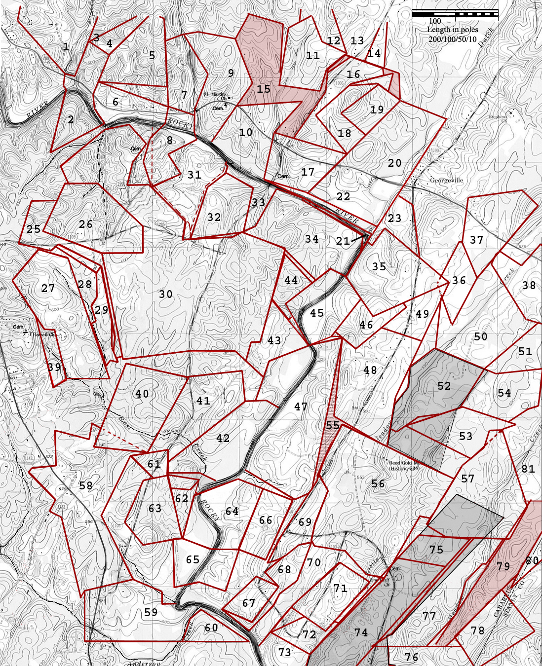
56. Grant #196, Cabarrus NC, ent. 18 Jul 1797, 11 Nov 1799, 8 May 1800, sur. 20 Oct 1800, iss. 5 Dec 1800. Issued to John Reed being a combined three entries making up 330 acres. The 1797 entry was for 110 acres “joining James Little, Isam Clay, Andrew Wats, George Tucker and round his old survey.” The 1799 entry was for 100 acres “joining George Tucker, John Tucker and his own lands.” Lying on Little Meadow Creek, the survey depicts the combined entries encompassing the original 30-acre tract acquired from Frederick Kiser. From a b. o. (near George Tucker’s line) north 22 east 5 to p. o., north 34 east 80 to p.o., (with or near Tucker’s line crossing Little Meadow Creek) south 60 east 160 to small p. o. (near a branch), south 65 east 100 to pine, (near John Tucker’s line) south 20 west 100 to p. o., west (with Tucker’s line) 29 to pine (Isham Clay’s corner), (with his line) south 30 west 172 to pine (James Little’s corner), (with his line) north 60 west 34 to p. o., north 48 west 68 to hic. (Little’s corner), (with his line) north twenty west 40 to p. o. grub, north 44 west 16 to p. o., (up the Flat Branch) north 12 east48 to p. o. (James Love’s corner), (with his line) north 20 east 78 to b. o. (Love’s other corner), then (with his other line) to begin. CC: James Little Esquire and George Teetor.
Grant # 3325, Mecklenburg NC, ent. 1 Jan 1780, sur. 24 Apr 1783, iss. 2 Nov 1784. Issued to Frederick Ciser, being 30 acres on both sides of Meadow Creek. The warrant was for 30 acres “in the forks of the first Meadow Creek where KIillone Wagon Road crosses it in tract no. 5.” Note that this tract represents John Reed’s original 30 acre purchase as appears in red in the above plat for grant #196. CC: George Tucker George Garmon.
57. Grant #97, Cabarrus NC, entered 19 Jan 1795, iss. 7 Dec 1797. Issued to George Tucker, being 45 acres on Big Meadow Creek. Beginning at hic (Thomas Berry’s corner and with his line) north 25 west 165 to po, west 26, south 9 west 36 to po, south 36 west 40 to po (in John Reed’s line), south 18 west 152 (with John Reed’s line) to po, south 60 east 52 to hic, north 42 east 10 to po, east 91 (Crossing the creek to a baptism hole), to stake, then to begin. CC: James Little, John Tucker.
58. Grant # 291, Cabarrus NC, ent. 21 Oct 1799, sur. ---, iss: 13 Dec 1803. Issued to James Love, the warrant to survey is for 320 acres “joining George Garmon, Charles Alexander, Archibald White, Jonathan Osborn, and Christopher Osborn.” From a large w. o. (on the side of a road) north 51 east 5 to small w. o., north 75 east 80 to stake (Archibald White’s corner), (with his line) north 67 to b. o. grub (in said line), south 75 east 40 to pine, north 20 east 40 to hic. , south 55 east 140 to pine, west 30 to pine, south 25 west 132 to hic., south 30 east 152 to p. o., south 78 west 122 to b. o., south 37 west 20 to hic. grub, north 15 west 190 to p. o., north 80 west 32 to pine, north 15 east 12 to pine, then to begin. CC: Jonah Love, __________.
59. Grant # 3185, Mecklenburg NC, ent. ________, sur. 22 Mar 1780, iss. 9 Oct 1783. Issued to Christopher Osburn, being 220 acres between Rocky River and Anderson’s Creek. The warrant to survey is for land joining George Garmon line, Michael Garmon‘s, the line that divides No. 2 and No. 5., and the land he bought of James Ashmore. From a small w. o. (on the bank of said creek and on the Barony line that divides tract 2 & 5) down the said creek to the mouth, up the river to w. o. (at the mouth of a branch on George Garmon’s line), with said line south 85 west to b. o. sapling (said Garmon’s corner), (with his other line) north 16 to w. o. (by a spring), north 62 west 62 to b. o. sapling, south 80 west 121 to b. o. sapling (on small branch), south 152 to stake (on Barony line), then to begin. CC: Michael Garmon, Joseph Howell.
61. Grant # 249, Cabarrus NC, 16 Oct 1798, sur. 7 May 1800, iss. 16 Dec 1800. Being 30 acres issued to John Howell. From a b. g. (on bank of the river, Joseph Howell’s corner) south 25 west 35 to pine, north 85 west 47 to b. o. sapling (on George Garmon’s line and Joseph Howell’s corner), north 20 west 26 to pine (Garmon’s other corner), south 79 west 25 to pine, (with conditional line between him and George Garmon) north 50 west 90 to pine, north 20 east 92 to r. o. (on the bank of David’s Creek in his old line), (with his old line)south 6 east 84 to stake (close by the pine his other corner), then to begin. CC: Thomas Love, Eli Howell.
62. Grant # 248, Cabarrus NC, 16 Apr 1779, sur. 5 Nov 1800, iss. 16 Dec 1800. Issued to Joseph Howell Senr., being 25 acres on the west side of Rocky River. From a b. g. (on the river, John Howell’s corner) south 52 west 35 to pine, (with John Howell’s other line) north 85 west 47 to b. o. sapling (in George Garmon’s line), (with his line) south 20 east 120 to p. o. (his old corner), then (with his old line) to begin. CC: Thomas Love, Eli Howell.
63. Grant 3502, Mecklenburg NC, ent. 14 Feb 1784, sur. 14 Jan 1785, iss. 7 Aug 1787. Issued to George Garmon, the warrant is for 74 acres “joining his own lands on the west side of Rocky River, joining Christopher Osburn, Peter Kiser dec’d, and perhaps Joseph Howell” lands. From a pine (his own old corner) south 86 east 24 to p. o. (his own old corner), (with Peter Kiser’s line) north 15 west 148 to pine, south 75 west 50 to pine, south 19 west 108 to hic., south 35 east 70 (along Christopher Osborn’s line) to pine, then to begin. Note that this tract should mate up with the lands of Jame Love, tract 58. However, when drawn, the plat is too small and fails to meet.
64. Deed 2-687, Mecklenburg NC, 25 Jun 1764, prv’d ____. Arthur Dobbs Esq’r and wife Justina to Peter Kiser. Being 101 acres located on both sides of Rocky River. The southern most lines adjoin George Garmon lands. Wit: ________
Deed 14-148, Mecklenburg NC, 31 Jul 1790, prv’d Jan 1793. George Hoice & Cath
65. Deed 2-659, Mecklenburg NC, 25 Jun 1764. His Excellency Arthur Dobbs Esq’r, Commander in chief over the province of North Carolina & Justina his wife to George Garmon. Being 81 acres on both sides of Rocky or Johnston’s River. This land may actually tie in to the notch in tract 60 in a way that the river runs through the middle and then bends to form the southeast line of the tract.
Deed 14-148, Mecklenburg NC, 31 Jul 1790, prv’d Jan 1793. George Hoice (Hice, Hise) & Catherine his wife to James Love, being 50 acres. Wit: James Harris and Henry (x) Smith.
67. Grant # 3399, Mecklenburg NC, ent. 12 Mar 1779, sur. 24 Apr 1783, iss. 2 Nov 1784. Issued to George Garmon, the warrant was for land “beginning at his own lower corner and running down the line of #2.” From a w. o. (his old corner) south 65 east 20 chs. to p. o., north 35 east 25 chs. (near his corner) to w. o., north 65 west 15 chs. to hic., then to begin. CC: John Reed, George Garmon.
68. Grant #335, Cabarrus County NC, ent. sur. 20 Mar 1806, iss. Issued for George Garmon, being 47 acres on the east side of Rocky River “joining his own, James Little’s & James Love’s lines.” From a w. o. (on bank of river, his own corner running down the river) south 49 east 89 to water oak (below the mouth of big gut, his other corner), (with a line dividing between himself & James Little north 37 east 98 to hic. (Little’s corner), (with Little’s other line) north 34 east 43 to hic. (Little’s other corner), (with his other line) north 48 east 36 gum sapling (on edge of dry drain), (up the drain) north 19 east 82 to Little’s other corner on bank of the Flat Branch), south 80 west 26 to b. o. sapling, south 52 west 100 to pine (James Love’s corner and his own line), (with his own line) south 44 east 50 to pine (his own corner), (with his other line) south 35 west 108 to w. o. (his other corner), (with his other line) north 65 west 80 to begin. CC: James Gray and _______.
69. Grant # 323, Cabarrus NC, ent. 6 Jan 1804, sur. 12 Jul 1805, iss. 22 Nov 1805. Being 91 acres issued to James Love. The warrant is for land adjoining John Reed, George Tucker and George Garmon. From a oine north 75 east 40 to pine, north 60 east 20 to pine, north 37 east 48 to b. o., north 75 east 25 to p. o., north 12 east 48 to p. o., north 20 east 78 to b. o., north 40 west 64 to b. o., south 25 west 20 to pine, south 31 west 112 to b. o., then to begin. CC: John Reed, Jonah Love.
70. Grant #234, Cabarrus NC, ent. sur. 17 Nov 1800, iss. Issued to James Little, being 70 acres. The survey starts at the big cut used to locate Garmon’s #335 above. The land adjoins George Garmon to the west, John Reed to the north and Isham Clay to the east. The land crosses Flat Branch and Little Meadow Creek above its mouth. From a water oak (on bank of river at mouth of deep gut running thence four conditional lines between him and George Garmon) north 35 east 100 to p. o., north 45 east 50 to hic., north 55 east 38 to s. g., north 25 east 86 (up the Flat Branch) to to p.o. (James Love’s corner), south 58 east 16 to p. o. grub (John Reed’s corner), (with his line) south 20 east 42 to hic (Reed’s corner), south 45 east 64 to p. o., east (crossing Meadow Creek) 32 poles to pine, Reed’s other corner), (with Clay’s line) south 30 west 94 to pine, south 22 west 28 to stake (in Clay’s line), north 11 west 24 to pine (his own corner), north 47 east 80 to p. o. (his old corner), north 43 west 70 (crossing Meadow Creek) to pine, south 47 west 112 to p. o. (his old corner), (with his old line again) south 46 west 75 to b. o., south 41 west64 to w,. o. (on bank of river) (his old corner), then to begin. CC: ________________.
71. Grant # 3290, Mecklenburg NC, ent. 12 Mar 1779, sur. 5 Feb 1784, iss. 2 Nov 1784. Issued to George Garmon, the warrant is for “40 acres on Meadow Creek above the wagon road that goes to Kiser’s mills.” The land adjoins his own to the south and Meadow Creek to the southeast. This tract nests under the overhanging portion of James Little’s grant # 234 above. From a b. o. (near his own old line by the creek) north 43 west 15 chs. to p. o., north 47 east 28 chs. to pine, south 43 east 15 chs. (crossing said creek) to p. o., then to begin. CC: John Corsire, Thomas Ingram.
72. Grant #104, Cabarrus NC, ent. 19 Jan 1795, sur. 3 Feb 1797, iss. 7 Dec 1797. Issued to James Little, being 32 acres lying on both sides of Meadow Creek adjoining his old line and Isham Clay lands. From a stake (corner of his old survey and running with his old line) south 60 east 101 to p. o. (his other old corner), north 44 east 80 to stake (in Isham Clay’s line), north 11 west 24 to pine, south 53 west 54 to b. o. (a corner of his other survey), north 43 west 30 to p. o. (in his other corner), then to begin. CC: John Tucker, Jacob Nees.
Deed 9-245, Mecklenburg NC, 3 Jan 1778, prv’d ___. Thomas Dove and Dorothy his wife to George Garmon. Wit: George Kiser, Archibald White.
Deed 2-143, Cabarrus NC, 10 Mar 1795, prv’d ___. Ebenezer Marsh to James Little. Wit: John Stucker, William Carriger.
Deed 6-16, Cabarrus NC, 25 Jan 1805, prv’d Jul 1805. James Little to William Bedford & Nathaniel Morton of County and City of Baltimore & State of Maryland, being 48 acres. Wit: Hu. Campbell, Js. Beard.
(Tract 1) Division 11-176, Cabarrus NC, Oct 1828, prv’d Sep 1829. Wm. Watson, John H. Bost, Daniel Boger and Jonah Love as commissioners divided the lands of Bedford and Morton. Nathaniel Morton received tract 1, being 175 acres - the northern half adjoining lands of Jonah Love, James Love, and John Reed.
Deed _____, Cabarrus NC, _______. George Tucker to John Reed Jr. Being tract #1.
(Tract 2) Division 11-177, Cabarrus NC, Oct 1828, prv’d Sep 1829. Wm. Watson, John H. Bost, Daniel Boger and Jonah Love as commissioners divided the lands of Bedford and Morton. William Bedford received tract 2, being 130 acres lying against the river between Little Meadow Creek, John Reed Jr, and Jonah Love land.
Deed 13-255, Cabarrus NC, 1 Dec 1838, prv’d Oct 1839. George Garmon and Nancy Linker to George Garmon Sen., being 115 acres on the mouth of Meadow Creek. Wit: Culpepper Howell, George Garmon.
Deed 14-286, Cabarrus NC, 29 Oct 1839, Prv’d Oct 1840. Henry W. Linker to George Garmon. Wit: Culpepper Howell, Isaac Linker. Being Tract #2.
Deed 14-318, Cabarrus NC, 18 Jan 1841, prv’d _____. Lewis B. Krimminger Esq., High Sheriff, to Robert Motley & Samuel Klutts. By virtue of an execution issuing from 1839 Cabarrus P & Q session against the property of Nancy Linker. Whereas Darling Love recovered a sum of $45.48 ˝ and 125 acres were ordered to be sold. Wit: H. S. Love.
74. Grant # 3562, Mecklenburg NC, ent. ---, sur. 22 Mar 1786, iss, 7 Aug 1787. Issued to Ebenezer March (Marsh), being 100 acres between the two Meadow Creeks. Beginning at a po north 64 west 22 to small po, north 16 east 48 to pine, north 32 east 234 (near George Garmon’s line) and past his corner) to pine, south 65 east 80 to stake, then to begin. CC: Gorg Garmor, Ebenezer March.
75. Grant # 239, Cabarrus NC, ent. 18 Oct 1800, sur. 12 Jul 1801, iss. ---. Issued to Isam Clay, being 46 acres on the waters of Rocky River. Beginning at po (on his open line) north 35 east 58 to pine, north 65 west 106 to pine, south 32 west 70 to stake (in his old line), then to begin. CC: Daniel Clay, George Teetor.
Deed prv’d Oct 1814. Enoch Morgan to John Reed, being … This tract includes all the gray shaded land encompassing key map tracts 74 and 75. Beginning at a stake north 70 west 102 (with John Reed’s line), south 32 west 368 to pine, south 16 west 48 to hic, south 35 east 80 to stump, north 76 east 110 to dog, north 10 west 32 to dog, north 38 east 26 to bo, north 19 east 10 to pine, north 52 east 51 to pine, north 30 to stake, south 75 west 38 to hic, north 70 west 17 to pine. North 72 to po, east 20 to po, then to begin.
76. Deed 5-166, Mecklenburg NC, 12 Nov 1789. George Graham Sheriff to George Teeter, “being 100 acres on both sides of Meadow Creek including his own mill.” Beginning at a stake north 60 west 12 to po, (with his own line) north 78 east 22 to po, north 30 west 40 to stake, north 74 west 24 to dog, north 10 west 32 to dog, north 38 east 26 to stake, north 3 east 24 to po (Eb Marsh corner on the creek), (with Eb Marsh’s line north 70 west 34 to pine, north 48 to po, (passing a po and crossing the creek) east 176 to pine, south 25 east 100 (crossing a branch of the creek) to pine, then to begin. Chas. T. Alex., jurat.
77. Grant #195, Cabarrus NC, ent 16 Apr 1799, sur. 14 May 1800, iss. 5 Dec 1800. Issued to James Little, Esquire, being 100 acres on the waters of Meadow Creek including the Baptising hole. Beginnning at a po (Isham Clay’s corner and George Teeters and runs with George Teeter’s line) east 144 to dog and wo sapling, (with Shinn’s entry) north 35 east 78 to po, (with said entry) north 14 east 30 to bo, (with said entry again) north 38 east 36 to po, (then said entry) north 83 east 2 to wo, north 43 east 26 to po (near Tucker’s corner), (with or near his line) west seventy four to po (Isham Clay’s corner), (with a conditional linebetween him and Clay) south 48 west 182 to po (at the Cross Roads), then to begin. CC: Dennis Clay, George Teeter.
78. Geo. Graham, Sheriff Geo Graham,Sheriff to Andrew Watts. Being 60 acres on both sides of Meadow Creek. Beginning at a bo north 40 west 66 to pine, (with George Teeter north 30 east 120 to po, south 40 east 92 to po, then to begin. Wit: William Ross.
79. Grant # 310, Cabarrus NC, ent. 6 Jan 1804, sur. ---, iss. 25 Oct 1804. Issued to James Little, being 70 acres on the east side of Big Meadow Creek. Beginning at po & dog (his own old corner and with George Teeter’s line) east 17 to pine (his corner), (with his other line) north 86 east 14 to pine (Andrew Watt’s corner), (with his line) north north 36 east 130 to po (his other corner), south 40 east 13 to bj, north 34 east 100 (passing pine corner) to stake, north 35 west 60 to stake, south 38 west 114 to po (his own old corner), then to begin. CC: George Tucker Jr, Jacob Tucker.
80. Grant 2829, Montgomery County NC, being …acres to John Barba.
81. Grant #433, Cabarrus NC, ent. Sep 5 1811, iss. 23 Nov 1812. Issued to John Reed, being 100 acres on the north side of Meadow Creek “joining George Harkey and his own lands.” Beginning at a po (on the county line and running with the line) north 26 east 160 to po, west 70 to pine, south 30 to stake, west 104 to stake, south 112 to stake, then to begin. CC: Geo. Harkey, Geo Garmon.
(NO PLATT) Deed 6-113, Cabarrus NC, ……. Agreement between Thomas Berry of Cabarrus and WilliamThornton of the City of Washington & District of Columbia. That they shall be joint tenants and not tenants in common in a certain tract of land surveyed for one hundred acres be the same more or less the said Thornton agrees to pay for the same to the state & the fee of surveying charged, the same amounting to six dollars, six shillings & eight pence, the said land being distinguished as joining the county line & his, the said Thomas Berry’s own land on Meadow Creek, entered Nov. 7th 1804 No. 652. It is also agreed between the said parties that whatsoever force the said Thornton may put or cause to be put on said land to search for gold, it shall not be required of the said Berry to put on any hands but that he shall be entitled to one fourth part of the gold obtainable and the said Thornton is to have three fourths of the same. This land was located nearby. William Thornton was father of the United States Patton Office, Designer of the United States Capitol Building, and invested in the purchase of approximately 65 thousand acres in now Stanly.
6101 Ballou Court
Raleigh, North Carolina
27609
Copyright © 2009 by George G. Thomas
The year 2000 tax map for Cabarrus County