Deed 13-659, Mecklenburg NC, ________, prv’d. Jul 1789. John and wife Elizabeth (X) Love to Charles McCammon. Being 52 acres, part of 87 acres on the south side of Rocky River. Wit: John Rouch
Deed 13-909 Mecklenburg NC, __________ . David Hart to Gustavus Rape, being 100 acres, the northern arm of tract # 31. Beginning at a bo, south 85 east 214 to stake, north 15 west 92 to stake and hic, (With Thois. Voil, north 88 west 192 to po, then to begin.
Deed 2-356, Cabarrus NC, 22 Feb 1797, prv’d Apr 1797. Being 166 acres from Andrew Miller of Mecklenburg to Frances Funderburgh, blacksmith, of Cabarrus. Wit: Daniel Jarret, Phillip Lyticker.
Deed 6-94, Cabarrus NC, 18 Sep 1804, prv’d Jul 1806. Elias Bost to John Bost his son, “a certain tract of land containing two hundred acres wheof 50 acres belong to the silver mine theron during the continuance of it & thereafterwards to revert to the said John Bost.” Now the stream running through the land is known as Whitford’s Branch. Wit: John Moyer, Daniel Bost.
Deed 14-33, Mecklenburg NC, 28 Aug 1789, prv’d Jan 1792. Robert Smith to William Ross, both of Mecklenburg. Being 100 acres adjoining John Finney to the east, his own and Peter Rape land to the north, and John Biggers to the west. Wit: Wallace Alexander, Sarah Alexander, Wm. T. Alexander.
Deed 2-38, Cabarrus NC, 19 Apr 1793, prv’d ___. Daniel Bean to William Ross Junior, being 100 acres. Wit: David McKinley, William Ross.
Deed 8-219, Cabarrus NC, 1 Nov 1793. William Ross Jun’r to Daniel Boger, both of Cabarrus. Being one of four tracts conveyed to Daniel Boger.
Deed 10-126, Cabarrus NC, 27 Jan 1801, John Melcher to Tobias Klutts, both of Cabarrus. Being one of four tracts conveyed in this deed all conveyed “from Dan’l Boger to sd. John Melcher bearing dated the 1st day of Nov 1793.” Wit: Dan’l Little, Jno. Still.
 5. Grant #3289, Mecklenburg NC, ent. ---, sur. 3 Mar 1784, iss. 2 Nov 1784. Issued to Martin Phifer, being 150 acres on both sides of English Buffalo Creek known from the warrant as “Phifer’s lower mill plantation joining John White on the west side, William White on the north side, and John Rodgers on the south.” The survey for Martin Phifer Senior locates a mill road on the western most corner of this tract. Beginning at a wo (John Rogers corner and running with his line and crossing English Buffalo) south 73 west 74 to hic, (north 36 west 72 (with John White) to pine, north 43 west 71 with John White) to po (on the mill road), north 28 east 84 to hic, north 52 east 22 (with Wm. White) to so (on the creek bank), north 40 west 61 with Wm. White) to po, north 82 east 106 to bo, south 122 to stake, then to begin. CC: Martin Phifer Jun’r, Paul Phifer.
 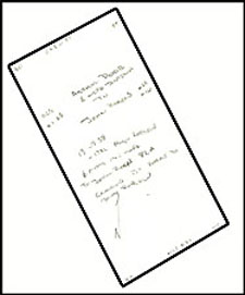 6. Deed ____, Mecklenburg NC, Arthur Dobbs and wife Justina to John Rogers.
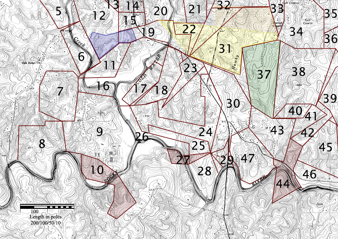
  7. Grant 3604, Mecklenburg NC, ent. 1 Jan 1779, sur. 12 Mar 1785, iss. 7 Aug 1787. Issued to John White Senor, being 130 acres on the Buffalo Creek joining John Love to the southeast, David Purviance to the southwest, and John Roch land to the northeast. CC: Thomas White, John White.
 8. Grant # 3428, Mecklenburg NC, ent.---, sur. 30 Aug 1782, iss. 2 Nov 1784. Issued to David Purvance, being 136 acres “lying on the north side of the river opposite James Love’s.” The warrant is for land joining James White Junior, James Love, and John Love. The eastern boundary is on the river at the mouth of a branch and the western boundary runs along another branch. The metes and bounds are from a w. o. (on bank of river near a branch next to John Love’s, then up the river) to a r. o. (near the river & branch his and James White’s conditional line), (up said branch) north 80 to small w. o. (on said branch), east 84 to small hic., north 40 to small w. o. sapling, east 68 to five small w. o., south 12 east 100 to begin. CC: John McClellan, David Purvance.
 9. Grant # 3640, Mecklenburg NC, ent. 16 Jan 1784, sur. 10 Jan 1785, iss. 7 Aug 1787. Issued to John Love, being 296 acres on the mouth of Buffalo (Coldwater Creek) where it enters the river. The warrant for this tract was made out in the name of John Rodgers – “a tract or parcel of land containing 350 acres lying & being on the Big Coldwater Creek including the lands and improvements said Rogers bought of James Balst dec’d joining James Bradshaw on the north Charles McCammon on the NE John Love on the NC David Purviance on the E and on the south of James Campbell & John Rosh.” The metes and bounds are: from a w.o. sapling (his own corner next to David Purviance’s land) south 62 east 53 (with own line) to small w.o. (his own corner), (with his other line) south 51 east 65 to pine (another own corner on the river bank), (down the river) to r. o. (at mouth of Buffalo Creek), (up the creek) to w. o. (on bank near James Campbell old line), (with or near Campbell line) north 79 west 129 to stone corner (in a draft), (with his and John McClellan’s conditional line) south 7 west 112 to p.o., west 42 to stone corner (David Purvience’s line), (with Purvience’s line) south 12 east 96 to small w. o. (on the river bank (Purvience’s corner), then to begin. CC: William Waddington, Abner Wenes.
 10. Grant 3224 Mecklenburg NC, ent. 25 Feb 1779, sur. 18 Mar 1780, iss. 9 Oct 1783. Issued to John Love, being 87 acres on both sides of Rocky River “including his own improvements where I now live.” The metes and bounds are from a large pine (on bank of river running then with his and John Rogers conditional line) north 51 west 65 to two w. o. saplings, north 62 west 53 to w. o. sapling, south 12 west 49 to stake (on bank of river”, down said river to stake on the bank of river, (the crossing the river south 70 east 32 to Spanish oak, south 57 to w. o., then south 26 west 51 to w. o. (near James Love’s survey), south 61 east 33 (crossing a small branch) to small b. j, north 51 east 73 to b. o., (the same course 20 to stake (on or near Thomas Watson’s line, then crossing the river to begin. CC: Charles Dorton, James Armstrong.
 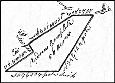 11. Grant # 26, Cabarrus NC, ent. 12 Feb 1788, sur. 20 Mar 1793, iss. 4 Jul 1794. Issued to Andrew Campbell, being 50 acres on the waters of Buffalo and Coldwater Creeks if the forks of sd. Creeks. Beginning at a pine (near his own old line) west 42 to pine, south 58 west 106 to p.o., south 28 east 20 to p.o. (John Rock’s old corner), (with his line) south 89 east 106 to hic. (near his own old corner, north 31 east 124 to begin. CC: John Rock, Andrew Campbell.
  12. Grant # 3312, Mecklenburg NC, ent. …, sur. 4 Mar 1784, iss. 2 Nov 1784. Issued to Martin Phiffer Junior, being 417 acres on Coldwater Creek. Beginning at a small w.o. (John Rodger’s and Martin Phifer Senior’ corner and running with Rodger’s old line) south 26 east 136 to p.o. (on sd. line), north 60 east 105 to small w.o., (with Andrew Campbell’s land) north 103 to two w.o.saplings, (with James Campbell’s land) north 54 west 98 to pine, (with sd. Campbell’s land) north 13 east 140 to pine, (With sd. Campbell’s land) north 64 east 65 to small w.o. sapling, (again with Campbell’s land) south 78 east 62 (crossing Coldwater Creek) to pine, north 21 east 22 (Crossing sd. creek above the shoals) to small dw, (with Phillip Wiser’s claim or entry land) north 61 west 85 to small w.o. sapling, south 81 west 121 (crossing the ridge road) to w.o sapling, south 46 west 104 to b.o. (Martin Phiffer senior’s corner), (with sd. Phifer’s line) south 122 to stake (sd. Phifer’s other corner), then (with his other line) to begin. CC: Andrew Campbell, Paul Phifer.
 13. Grant 3644, Mecklenburg NC. ent. _______________. sur. ______________ iss. ____________ . Issued to James Campbell, being .. acres on Coldwater Creek beginning at a gum north 23 east 71 to pine, south 78 west 62 (crossing the creek) to wo, (with Martin Phifer) south 64 west 65 to pine, (with Martin Phifer) south 140 to pine, (with Martin Phifer) south 54 east 98 to two wo, north 70 to stake, then to begin.
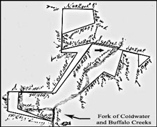 15. Grant # 483, Cabarrus NC, ent. 13 Aug 1813, sur. -----, iss. 26 Jun 1817. Issued to Eugenia Campbell 106 acres lying on the waters of Coldwater and Buffalo Creeks. Beginning at dead w.o. (on the west bank of the creek – George Teagleman corner when enteed John White’s) north 79 west 133 to stone (Teagleman’s heir’s corner), north 45 to s.o. (John Bost’s corner – when entered James Hudson’s), north 10 east 14 to p.o. (John Bost’s and Lewis Campbell’s corner), south 89 east 126 to stake (Lewis Campbell’s corner), north 31 east 138 to pine (Zeno Campbell’s corner), west 46 to small pine, north 128 to p.o. (in a draft – John Bost’s, Thomas White’s, and Callist Campbell’s corner), north 89 east 90 to p.o., south 10 east40 to p.o. (his own corner), south 69 west 101 to stake, south 46 to stake, north 75 east 92 to syc, south 80 east 74 to stake (on the creek bank), south 20 east 6 (crossing the creek) to pine, south 78 east 96 to s.o. and dw, ---47 west 45 to w.o., north 1 west 37 to w.o., north 78 west 47 to p.o., south 16 west 78 to p.o., north 64 west 34 to pine, south 47 west 94 to ma (on the creek bank below the old ford), north 80 west west 74 to stake, south 35 west 186 to s.g., north 89 west 106 (crossing the creek), south 3 east 50 (crossing the creek twice) to ash (near the creek), south 17 east 106 to begin.
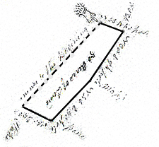 17. Grant # 3369, Mecklenburg NC, ent. 9 Apr 1779, sur. 16 Mar 1784, iss. 2 Nov 1787. Being fifty acres on the east side of Coldwater Creek including his own improvements that was issued to James Bodle, son of and heir of the late deceased John Bodle. Beginning at a small w.o. sapling (near a corner of James Bradshaw’s land and running with sd. Bradshaw’s line) north 66 west 40 to a b.o. sapling (on James Campbell’s old line), (with sd. line) north 38 east 94 to a maple (on bank of creek sd. Campbell’s old corner), (nearly with his other line) north 46 east ninety, south 60 east 53 (13 poles past a small w.o. to a stake, then south 46 west to begin. CC: James Campbell, Andrew Campbell.
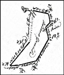 18. Grant # 24, Cabarrus County NC, ent. 12 Feb. 1788, sur. 23 Feb 1793, iss. 9 Jul 1794. Issued to Andrew Campbell, being 50 acres on the waters of Coldwater Creek. Beginning at a p.o. south 75 east 54 to w.o., south 11 east 30 to w.o., ssouth 43 west 20 to pine (James Bradshaw’s corner), (with his line) south 11 east 42 to b.j. (his corner), (with sd. Branshaw’s line) south 30 west 92 to p.o. (Sd. Bradshaw’s corner), south 78 west 60 to p.o., west 28 to w.o. (in a hollow), north 41 east 106 to p.o. (Sd. Bradshaw’s corner), then to begin. CC: James Campbell, Andrew Campbell.
  19. Grant # 3539, Mecklenburg NC, ent. 10 Apr 1780, sur. 16 Mar 1784, iss. 7 Aug 1787. Issued to Andrew Campbell (son of the late deceased James Campbell), being 100 acres on both sides of Coldwater Creek beginning at a small w.o. (running with an entry made by William Dorton) north 53 east 45 to small pine, (with said entry again) east 45 (crossing sd. creek) to small b.o. sapling, (with sd. entry again) south 9 east 53 to pine, east 732 to small b.j., south 9 west 70 to dw and crooked s.o., north 78 west 94 to pine (on bank of sd. creek), (crossing sd. creek) north 6 to stake (now the corner of the old place and with the line of sd. place) north 80 west 71 to large pine (the other old corner of the old plantation), south 75 west 92 to small w.o. (Martin Phifer’s corner), (with sd. Phifer’s line) north 44 to stone corner (on sd. line), then to begin. CC: William Balch, James Campbell.
 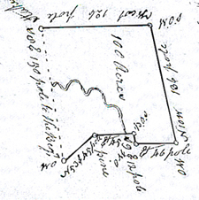 20. Grant # 3544, Mecklenburg NC, ent. 9 Apr 1779, sur. 6 Mar 1782, iss. 7 Aug 1787. Issued to James Bodle, being 100 acres on both sides of Coldwater Creek. The warrant is for land on the “upper side of Dutch Wagon Road.” This land was originally entered by William Dorton. The southern boundaries of this tract mates with the northern boundaries of Andrew Campbell’s grant # 3539. A later grant by Eugenia Campbell locates an old ford across Coldwater creek near the crossing of the creek along the southern lines of this tract. The metes and bounds are: begin at a W. O (Andrew Campbell’s corner) north 53 east 45 pls. pine (his other corner), (with other line) east 445 (crossing creek ) to B. O. (another corner of sd. Campbell), (another line of his) south 9 east 12 pls. W. O., east 46 pls. W. O., north 10 west 136 pls. W. O., west 126 stake, south 8 east 150 pls. (crossing sd. creek) to begin. CC: William Black, Andrew Campbell.
 21. Grant #3564, Mecklenburg NC, ent. 20 Mar 1780, sur. 17 Mar 1784, iss. 7 Aug 1787. Issued to Barnheart Housman, the original warrant was land for William Dorton. Being 50 acres of land on Coldwater Creek joining David Hart land to the east and James Bodle land to the west. CC: George Townsen, James Campbell.
 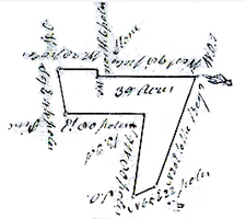 22. Grant # 82, Cabarrus NC, ent. 1 Feb 1794, sur. 22 Nov 1794, iss. 20 Dec 1796. Issued to Andrew Campbell, being 39 acres on Coldwater Creek. Beginning at a small crooked wo sapling (in a draft – Henry Townsend corner), west 98 to wo sapling, north 6 to stone (on Bodle’s line), (with sd. line) west 38 to wo (bodle’s corner in his own line), soutn 9 east 44 to pine (his own corner), (with his other line) east 80 to bj sapling (his other corner), (with his third line) south 9 west 80 to stooping so (his third corner), north 65 east 22 to pine (David Hart’s corner), (with or near sd. Hart’s line) north 20 east to begin. CC: Thomas Voiles, Phillip Wiser.
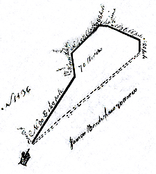 23. Grant # 3822, Mecklenburg NC, ent. 2 Jan 1787, sur. 1 Aug 1790, iss. 20 Dec 1791. Issued to James Bradshaw, being 70 acres on Rocky River. Beginning at two b.j. (near his own old line) north 30 east 142 to b.j., north 10 west 44 to pine, north 45 east 64 to r.o. (Andrew Campbell’s corner), north 27 east 8 to hic., east 14 to pine (David Hart’s corner and runs with is line) south 69 east 66 to w.o. (his own old cornerm then south 20 to stake, then to begin. CC: James Bradshaw, Robert Watson.
 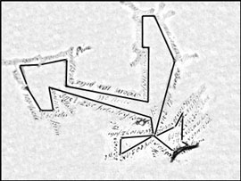 24. Grant # 72, Cabarrus NC, ent. 22 Apr 1794, sur. 24 Nov 1794, iss. 24 Jul 1794. Issued to James Bradshaw, being 110 acres joining the Rocky River on the southeast. This tract joins his own lands to the southwest and northeast. It adjoins lands of John Biggers to the east. The tract also joins lands of Andrew Campbell and John Bodell heirs to the northwest. Though most of this land sprawls north into map X, the southern lines are of importance. There are several important tracts in between and around the two lower appendages. The metes and bounds are from b. o. (his own corner and with his line) south 8 east 37 to hic. (his other corner), (with his other line) south 81 west 72 to b. o. (his corner), south 8 west 32 to w. o. (his own corner), with his own line north 61 east 88 to hic. (his own corner), (with his own line) south 51 east 58 to beach (his own old corner on the river bank), (along the bank of the river) north 50 east 14, (then along the river bank again) north 75 east 13 to pine, (with lines made between him and John Bigger) north 39 west 15 to p. o., north 3 ˝ west 20 to b. o. grub, north 41/2 east 36 ˝ to dog, north 12 west 9 to b. o. (in Bigger’s line), south 28 west 36 to s. o. grub (his own corner), (with his own line) south 65 west 49 to hic. his own old corner, (with his other line) north 15 east 170 to stone (his own corner), (with his own line) north 23 west 99 to w. o. sapling, north 25 west 13 6/10 to large p. o., west 28 to w. o. sapling, south 74 to pine, east 14 to stake, south 118 to stake, north 80 west 184 to stake, north 50 to pine (next to Andrew Campbell’s, then near the land of the heirs of John Bodell) south 76 west 63 to stone, south 85 west 42 to hic. grub (his own cornerold corner), (with his line) south 27 east 106 to b. o. sapling (his other corner), (with his other line) east 30 to pine (his corner), (with his line) north 10 west 58 to stake (his corner), (with his line) south 75 east 230 to begin. CC: John Bradshaw, James Bradshaw Junr.
 25. Grant # 3552, Mecklenburg NC, ent. 4 Apr 1780, sur. 4 Mar 1785, iss. 7 Aug 1787. Issued to James Bradshaw, being 40 acres on Rocky River. The metes and bounds are from a b.o. south 13 east 8 ch. 50 lks. to hic. (his own old corner), south 81 west 18 chs. to b. o. (on his old line), (with his line) north 10 east 14 chs. 50 lks. to pine (his old corner), (with his line) west 40 chs. 50 lks. to pine, north 10 west 13 chs. to stake, then to begin. CC: Isaac Breedon, Charles Dorton.
 26. Grant # 3165, Mecklenburg NC, ent. 20 Mar 1780, sur. 3 Apr 1780, iss. 22 Oct 1782. Issued to James Bradshaw, being 95 acres on the Rocky River lying east of Cold Water Creek adjoining lands of James Campbell to the northwest. The metes and bounds are from an elm (on bank of river) running south 57 east 13 Ľ to small b. o., north 20 east 88 to small w. o., west 192 b. o. sapling, north 27 west 106 to hic. grub, west 46 to small w. o. sapling (on bank of Coldwater Creek by James Campbell’s corner b. o.), (down said creek and river as they meander) to begin. CC: James Campbell, Andrew Campbell.
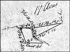 27. Grant # 584, Cabarrus NC, ent. 7 Feb 1824, sur. 15 Sep 1824, iss. 8 Apr 1825. Issued to Tobias Furrer, being 17 acres on both sides of Rocky River (see red shaded tract). In 1782, Charles McCammon received grant # 3119 for 195 acres on the south side of Rocky River opposite the mouth of Cold Water Creek. The track excluded abut 20 acres along the river. Adjoining lands of Thomas Watson (to the south and not shown) identify corners as being located “on the Indian path.” Extrapolating the path north, I am sure the path once crossed within the area of grant 584. The path likely turned northeast across the river where it ran the high ground where Hwy 601 is located. This vacant land appears to have remained vacant from 1782 up through the time that Tobias Furr entered a land grant for it in 1824. I wonder if Charles McCammon provided a right of way for passage for the Indians that was later back filled by Tobias Furrer’s grant? Was the area an ancient camp on the river? Could it represent a burial ground? The metes and bounds of the triangular portion of this tract perfectly match that of the southwest leg of grant 72 above. The survey for grant # 584 identifies lands on both sides of the northern triangular portion of this tract as belonging to Josiah Bradshaw. John H. Bost owned adjoining land along the river to the west and Charles McCammon owned the joining land on the south side of the river. The metes and bounds are from a w. o. (Josiah Bradshaw’s corner) north north 61 east 88 to stake, (said Bradshaw’s corner), south 81 west 72 to b. o. (said Bradshaw’s corner), north 57 west 131/2 to elm (John H. Bost’s corner), (up the river) 40 to ash (on the est side of the river, Joseph McCammon’s corner), south 24 east 48 to b. o. (sd. McCommon’s corner), east 40 to stake (on the bank of the river, said McCommon’s corner), (up the river) to begin. CC: Hiram Smith, Joseph Smith.
  28. Deed 10-118, Mecklenburg NC, 6 Jan 1768, prv’d Apr 1794. Hugh Eadger to James Bradshaw, being 63 acres on Rocky River purchased on an unknown date from Arthur Dobbs. The lower appendage shapes in Grant # 72 stradde this tract. The metes and bounds are from a beach (on the river bank) north 29 west 80 to hic., south 61 west 88 to oake, (down the various courses of river) to begin. Wit: Rob’t Harris, Rob’t Harris Jun’r.
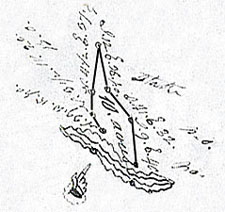 29. Grant # 232, Cabarrus NC, ent. 9 Apr 1801, sur. 22 Jul 1801, iss. 30 Nov 1801. Issued to John Biggers Sen, being 10 acres on the north side of Rocky River. From a stake (in the river, running then with Bradshaw’s lines) north 39 west 15 to p. o. (Said Bradshaw’s corner), north 3 ˝ west 20 to b. o., north 4 ˝ east 37 to dog, (with his old line) south 12 east 36 to stake (in his own field), (with his other line) south 41 east32 to p. o., south 9 east 40 to stake (on bank of river), (across the river) south 4 to stake, then to begin. CC: David Bradshaw, Joseph Biggers.
 30. Grant # 3168, Mecklenburg NC, ent. 25 Feb 1779, sur. 3 Apr 1780, iss. 22 Oct 1782. Issued to James Bradshaw, being 50 acres on Hamby’s Run.The warrant to survey is for land “Lying between the Run Paths and Hamby’s Run joining his own line, John Biggers, George Carrigor, Elizabeth Miller, and the Barrons. Beginning at a small hic (his old corner of the place he lives on) south 65 east 49 to small s.o. grub, (with John Biggers entry) 18 east 51 to pine, north 65 east 62 to stake, (with Carrigar’s entry) north 12 east 74 to small pine sapling, (with David Heart’s entry) north 15 west 22 (crossing Hamby’s branch) to hic sapling, (with Heart’s entry) north 31 west 95 to w.o. and elm (on bank of of sd. branch again with sd. entry) north 70 west 82 to w.o., (with Barron’s south 11 east 156 to stake, then with sd. Barron’s to begin. CC: Andrew Campbell, James Campbell.
 31. Grant # 3652, Mecklenburg NC, ent. 21 Aug 1779, sur. 27 Apr 1783, iss. 7 Aug 1787. Issued to David Hart, being 200 acres lying on both sides of Hamby’s branch and including his own improvements. This conveyance is identified as all of that land outlined encircled in red around #31. The warrant to survey is for land ‘Joining widow Miller in No. 2 west sides and James Bradshaw entry, Philip Carrigar and Thomas Voyles.’ Beginning at a pine south 69 east 42 ch 50 lks (along James Bradshaw’s line past his corner), (with his line) north 75 east 31 ch to s.o., north 20 east 6 ch 50 lks to pk near a w.o., north 15 west 23 ch and (supposed to be widow Miller’s line) to a stake by hic (Thomas Voils line), (with his line) north 88 west 26 ch. (Crossing sd. branch to stake, then to begin. CC: Andrew Campbell, George Carrigar.
  32. Grant #3309, Mecklenburg NC. Issued to Thomas Voil. Beginning at po (David Hart’s corner) south 88 east 196 to po (by Hart’s corner), north 100 to bo and stake (On his father’s line), (with his father’s line) north 73 west 50 to bo, north 16 west 18 to po, north 83 west 28 to wo (John Voil corner), north 75 west 104 to stake, then to begin. CC: David Carlock, Charles Hart.
 33. Grant # 362, Cabarrus NC, iss. 9 Nov 1802. Issued to George Smith, being 38 acres.
  34. Grant # 3617, Mecklenburg NC, ent. 1 Mar 1779, sur. Jan 19 1786, iss. 7 Aug 1787. Being 166 acres issued to “Nathan Orr, Administrator of John Miller’s estate late dec’d.” The warrant is for200 acres for Nathan Orr Senior, “Administrator of the estate of John Miller on behalf of the orphans of sd. John Miller.” Loose estate papers filed in Mecklenburg County name Nathan to be guardian of the orphans Samuel, Andrew, and John Miller. This land is located on the east fork of Hamby Branch known as Plumb Run. The land adjoins George Carriger, to the south, Elizabeth Miller to the southeast, David Hart to the west, and Andrew Carriger to the northeast. CC: George Carriger, Andrew Carriger.
 35. Grant #150, Cabarrus NC, issued to John Barnhart, being 115 acres issued 26 Dec 1799.
  36. Grant # 417, Cabarrus NC, ent 18 Jul 1809, sur. 23 Oct 1809, iss. 30 Nov 1810. Issued to Andrew Caricker, being 160 acres on the east side of Big Cold Water Creek joining Francis Funderburg, George Carricker, Elias Bost, Phillip Litaker and his own line. Beginning at a p.k. (his own corner of Funderburg’s line and running with his line) south 52 to small w.o. (on George Carriker’s line), (with his line) north 87 east 58 to p.s. (sd. Carriker’s corner), (with another of his lines) south 38 east 45 to b.o. (Sd. Caricker’s and Bost’s corner, (with Bost’s line north 77 east 124 to small b.o. (by an old road, Bost’s other corner), north 43 east 19 to b.o. Lytacker’s corner and Eafort’s corner), (with Eafort’s line) north 19 east 162 to w.o. (dead, his own old corner), (with his own old line) to begin. CC: Jacob Caricker, Philip Caricker.
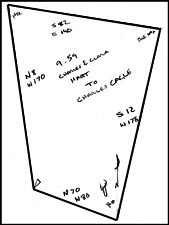 37. Deed 9-59, Mecklenburg NC, Charles (H) and Clara (X) Hart to Charles Keagle, being 115 acres on the “fork of Plumb Run and Hamby’s Branch.” Shaded in green, the metes and bounds on this and later conveyances of this tract do not construct a closed shape. Looking at surrounding lands, an error in direction of one line can be deduced. Instead of running 80 degrees north the line in question should run 8 degrees. The metes and bounds are: from a R. O. north 70 west 80 to stake, north 8 west 170 to Hic., south 82 east 140 to W. O., south 12 west 178 to begin.
 38. Grant # 3561, Mecklenburg NC. Issued to George Carrigor (Carricker), being 200 acres on Plum Run. Beginning at a stone west 152 to pine, north 48 west 59 to wo (own and Orr’s corner), south 8 west 242 (on own line passing his old corner), to ro, north 50 east 73 to ro, east 94 to stone (six feet from John Finney), south 57 east 20 to bo, north 22 east 186 to begin.
  39. Grant # 3885, Mecklenburg NC, ent. 14 Apr 1784, sur. 15 Nov 1790, iss. 28 Nov 1792. Issued to John Ashly, being 200 acres on Wetfot Branch adjoining George Caricker to the northwest and John Finny to the southwest. From b. o. south 55 west 34 to b. o. (George Carricker corner), (with his line) south 35 west 138 to pine not, south 47 east 78 to w. o. (John Finney corner), south 28 east 90 to stake (Jacob Keser’s line), (with his line) north 66 east 30 to pine (his corner), due east 36 to b. o., south 73 east 100 to big pine, north 25 east 100 p. o., then to begin. CC: Daniel Winchester, Andrew Mathias.
 41. Grant #3374, Mecklenburg NC, ent. 3 Mar 1779, sur. 23 Apr 1783, iss: 2 Nov 1784. Issued to John Finny, being 28 acres on the “Brushy Fork of Rocky River.” The tract adjoins John Leatsinger to the southwest and runs along James Cotise land to the west. Beginning at a hic north 18 east 15 ch to bo, north 52 east 16.5 ch to po, south 52 east 15 ch to ro, then to begin. CC: Robert Biggers, James Cortise.
 42. Grant # 448, Cabarrus NC, ent. 3 Feb 1812, sur. 2 Aug 1813, iss. 24 Nov 1813. Isued to Francis Fonderburgh (Vanderburg), being 24 acres joining his own, Daniel Boger, and John Bost’s lines. Beginning at a hic. (his own corn Daniel Boger’s corner on the bank of the brushy fork of Hamby’s Branch) south 51 east 60 to po (Boger’s other corner), north 46 east 132 to stake (on John Bost’s line), (with his line) north 4 west 96 to pk (Bost’s corner on Philip Carriker’s line), (with his line) south 35 west 8 to bo (his own corner), (with his own line) fifty two east 96 (To his other corner), then (with his own line) to begin. CC: William Plott, Francis Fonderburgh.
 43. Grant # 3308, Mecklenburg NC, ent. 9 May 1780, sur. 23 Apr 1783, iss. 2 Nov 1784. Issued to George Gerogor, being 100 acres on Hamby’s Branch. The warrant is for 200 acres “joining the lower end of the widow miller’s place & James Bradsaw line John Bigger line and down the river. ”The survey is for land that includes “Peter Reap and Jame Cortise improvements.” From a w. o. (by James Brachey’s corner on the Dutch Wagon Road) north 16 east 17 chs. to small hic., south 57 east 17 chs. (crossing a branch) to hic., south 87 east 24 chs. 50 lks. to b. o., south 17 west 13 chs. 50 lks. to hic. (John Leatsinger’s corner), (then with his line) south 20 west 23 chs. 50 lks. to p. o., north 74 west 9 chs. 50 lks. (crossing said branch) to p. o. (John Bigger corner), then to begin. CC: Robert Bigger, John Finny.
  44. Grant # 3347, Mecklenburg NC, ent. 18 Dec 1779, sur. 23 Apr 1783, iss. 2 Nov 1784. Issued to Peter Ciser, the warrant is for 100 acres on both sides of Rocky River “including his mill and mill dam being 50 acres on each side said river.” The survey ”includes his John Leatsinger’s improvemant.” The mouth of Hamby Run is located on this tract.This deed likely shows the earliest titles for what is now known as Bost’s mill. From a water oak (on bank of river John Finney corner, running with 30 east 15 chs. to small p. o., north 51 west 14 chs. to hic. (John Finny, Peter Reap corner), (with Reap’s line) south 20 west 23 chs. to p. o., north 74 west 9 chs. (crossing Hamby’s Run) to small p. o. (Reap’s corner & John Bigger corner), (with Bigger’s line) south 8 west 9 chs. to w. o. (his corner) south 30 east 7 chs. to water oak (Bigger’s corner on bank of river), south 15 west 31 chs. (crossing said river) to small b. o., then to begin. CC: Andra Mathews, John Bigger.
 45. Grant # 3700, Mecklenburg NC, ent. 27 Jun 1786, sur. 28 Apr 1787, iss. 26 Nov 1789. Issued to William Ross, the warrant for survey was for150 acres of land “joining John Finney, Peter Rape, John Finney’s entry on Brushy Fork, Jacob Casle, Andrew Mathews, John Ahsly, George & Andrew Carriger, and his own mill. The survey and issuance was for 97 acres joining John Ashley land to the east and John Finney land to the west and south. From a pine (John Ashly’s corner and with his open line) north 5 west 158 to stake, north 36 west 22 to p. o. (John Finny corner), (with Finny open line) south 44 west 162 to small p. o. (his own corner and Finny corner), (with his own line) south 30 west 50 to stake (by Finny corner), then (with his open line) to begin. CC: John Finny, James Bigger.
 46. Grant # 3319, Mecklenburg NC, ent. 3 Mar 1779, sur. 23 Apr 1783, iss. 2 Nov 1784. Issued to John Finney, being 50 acres on the north side of Rocky River including his own improvements. From a hic. (Douglas Winchester’s line, running with his line) south 9 west 9 chs. to small p. o. (on river bank), (with various courses of river) north 84 west 15 chs. to small water oak, south 70 west 12 to water oak (John Leatsinger’s corner), (along his line) north 37 west 12 chs. to b. o., north 20 west 7 chs. to b. o. (said Leatsinger corner), north 8 east 8 chs. to stake, then to begin. CC: Andre Mathews, Robert Bigger.
 47. Grant 3346, Mecklenburg NC, ent. 8 Sep 1779, sur. 23 Apr 1783, iss. 2 Nov 1784. Issued to John Biggers, being 100 126 acres on the north side of Rocky River including his own improvement. The warrant is for land joining James Bradshaw, George Garriger, and Rocky River. The metes and bounds are from a p. o. (John Leatsinger corner) south 8 west 9 chains to w. o. (his other corner), south 30 east 7 chains to w. o. (leatsinger’s corner on bank of river), (with various courses of river) south 45 west 14 chains to b. o., south 64 west 15 chains to b. o., north 47 west 4 chains to pop., north 9 west 14 chains to pine (James Bratchey’s corner), (along his line) north 64 east 15 chains to pine knot, then to begin. CC: John Finny, James Cortis.