2. Deed 7-104. Mecklenburg NC. Thos Polk, Attorney for David Olliphant, to Michael Garmon. Being 143 acres beginning at a bo north 37 east 86 to bo, north 20 east 48 to po, east 140 to bo (on river bank mall), south 3 west 150 to wo (on the river), then to begin.
3. Deed 14-75, Mecklenburg NC, 19 Jul 1793, prv’d Apr 1795. Andrew Alexander, Esq., high sheriff of Mecklenburg to Michael Garmon, being 246 acres. The metes and bounds are from a p.o. south 54 west 66 to p. o., north 50 west 66 to w. o., north 25 east 125 to p. o., north 18 east 32 to hic., south 87 east 20 to b. o. (his own corner), (with or near his open line) south 80 east 62 to forked p. o. (on or near said line), north 4 east 7 to p. o., south 83 east 140 to pine, (with his line) north 2 east 150 to b. o. (on river bank), (down said river) south 29 east 90 to w.o. (on bank of river), (down said river) soiuth 57 east 16 to hic. (his corner), (with his line) south 35 west 88 to small b. o. (instead of pine, his own corner), (with another line of same survey) south 24 west 40 to p. o. (his other corner), (with another line) south 68 east 116 to hic. (his corner on the river bank), (down river) south 25 west 27 to hic (by the river), north 77 west 78 to pine, south 42 west 6 to b. o., north 77 west 140 to pine, then to begin.
4. Deed 6-53, Mecklenburg NC, 5 Feb 1771, prv’d 5 Feb 1771. Abner Nash and Justina his wife to Burdig Howell. Being 68 acres, the metes and bounds are: from a w. o. (on the south bank of Rocky River, running thence down the river) 144 to hic., north 66 west 114 to w. o., north 26 east 38 to pine, north 37 west 88 to hic. (on the river), then down the river to begin. Wit: Clement Nash.
Deed 6-128, Mecklenburg NC, 16 Dec 1771, prv’d Apr 1772. Burdig Howell to Peter Kizer, being 68 acres. Jurat: John Polk.
Deed 6-135, Mecklenburg NC, 1 Apr 1772, prv’d Apr 1772. Peter Kizer to Joseph Garrot, being 68 acres. Jurat: ___ Polk.
Deed 7-385, Mecklenburg NC, 10 Jan 1774, prv’d (record lost). Joseph (J) and wife Suzana (x) Gault (surname may be wrong as writing is not clear) to William Mitchell being 68 acres. Wit: Peter (x) Curzine, Moses (x) Burleson.
Deed 10-475, Mecklenburg NC, 2 Feb 1779, prv’d _____, William Mitchell to Leonard Green. Wit: William Barker, Elizabeth Balch.
Deed 11-323, Mecklenburg NC, 1 Feb 1780, prv’d Apr 1780. Leonard (L) and wife Ann (x) Green to Samuel Bonds, being 68 acres. Wit: William Haynes, Jacob Self.
Deed 13-779, Mecklenburg NC, 29 Jan 1789, prv’d Apr 1790. Samuel Bonds to Michael Garmon. Wit: Willi Potts, John McGuirt, Arch, White.
6. Deed 17-398, Mecklenburg NC, 12 Nov 1789, prv’d Apr 1800. Geo. Graham Esq. late sheriff of Mecklenburg to Henry Smith. The metes and bounds are from a hic. (on the bank of the river) north 80 west 14 ch to pine, south 20 west 11 ch to p.o, south 45 west 21 ch to pine, south 20 west 36 ch to p.o. (on Meeting House Branch), then down the courses of the branch to the river and up the river to Henry Smith’s old corner., then around his old land to begin. (not represented by the plat to the left) Wit: Charles T. Alexander.
Deed 11-282, Cabarrus NC, 16 Feb 1830, prv’d Apr 1830. Jacob Petre to John Beckwith & Co. of Wake County NC. Situated on the west side of Rocky River, this tract has changed a little in shape and length of lines. The branch on the southern line is now known as “the Malling branch” adjoining the ‘Rung’ land as it meanders to the river. Wit: Isaac Watson, J. W. Means.
Deed 17-237, Cabarrus NC, 26 Feb 1845, prv’d _______. Laird Alexander & Cyrus C. Alexander & Green H. Swearengen to Hartwell S. Love.
7. Deed 13-892, Mecklenburg NC, 18 Jun 1785, prv’d Apr 1791. Thomas Harris Esq., late Sheriff of Mecklenburg NC to Isaac Garmon. Wit: Charles Harris, Isaac Garmon. Being 100 acrs on Rocky River “Running round his old survey.” Wrapping around the west side of the red shaded tract identified above, the metes and bounds are from p. o. (on the wagon road) south 60 east 116 to pine, south 27 west 40 to small p. o. (his old corner), (with his line) north 63 west 80 to p. o., south 31 west 134 to pine (his corner), (with his open line) south 35 east 90 to b. j. (his corner), south 26 west 76 to b. j., west 80 to b. o., north 22 west 80 (near David Powell’s line) to stake, then to begin. Wit: Charles Harris, Wm. Cupples.
Deed 10-30, Cabarrus NC, ____1811, prv’d _____. John Reed Sen’r to Henry Reed. Being two pieces of land on the west side of Rocky River adjoining each other “put in one tract” so as to make up 200 acres where “the said Henry Reed now lives.” Wit: William Creaton.
Deed 10-367, Cabarrus NC, 15 Apr 1826, prv’d Oct 1826. Daniel Sossamon to Tobias Klutts. Being 122 acres on the southwest side of Rocky River on a branch of same. The metes and bounds are now from a stake, (east side of Charleston Road, south 60 east 120 to a stake, then south 25 west 172 (along Garmon’s line) to w. o ) corner of Elizabeth Leopard, north 65 west 146 to stake (corner of Leopards), then north 30 east 186 to begin. Wit: Henry Reed, Wm. Gilliam.
Deed 12-79, Cabarrus NC, 1833, prv’d---. Tobias Klutts to Green M. Burkhead, veing the same 172 acres as described in Deed 10-367 above. Wit. Robert S. _____, & Sam’l C. Klutts.
Deed 13-394, Cabarrus NC, 15 Nov 1841. prv’d ____. John E. Garmon to James S. Burkhead. Wit: Henry Garmon.To settle debts, John Garmon sold all his standing crop, household furniture and the 98 acres tract adjoining J. S. Burkhead and Dvid Kiser. Wit: Henry Garmon.
Deed 5-191, Cabarrus NC, 1 Aug 1804, prv’d Jan 1805. Peter (x) Long to George Kiser. Being 60 acres at the mouth of Meeting House Branch. Wit: Samuel McCurdy.
Deed 6-44, Cabarrus NC, 22 Oct 1805, Oct 1805. George Kiser to David Kiser. This 60 acres is the second of two tracts conveyed. The first tract is for 53 acres adjoining tract two. (See 1-164 above). Wit: Mark Kiser, Esther ( ^ ) Keiser.
Deed 6-44, Cabarrus NC, 22 Oct 1805, Oct 1805. George Kiser to David Kiser. This 53 acres is the first of two tracts conveyed. The second tract is 60 acres adjoining tract one and Meeting House Branch. (See 5-190 below). Wit: Mark Kiser, Esther ( ^ ) Keiser.
12. Deed 10-288, Cabarrus NC, 6 Nov 1824, prv’d Jul 1825. Being 230 acres from Thomas Kiser to Nathan Green. The metes and bounds are from a p.o (on the river bank), south 82 west 96 to p.o., west 126 to pine, south 42 west 90 to p.o. (in Garmon’s line), south 45 west 18 to hic. (in said line, McLarty’s corner), (with the division line between him & McLarty) east 174 to p.o., south 39 ˝ east 110 to r.o. (the old line with said line), north 80 east 24 to bank of river, up the river to begin. Wit: Wm. Waddington, David Kiser.
14. Deed 7-31, Cabarrus NC, 6 Jan 1807. John (x) Powell to Alexander McLarty, being 208 acres on the waters of Rocky River. Beginning at an elm (on the river bank) north 25 west 50to wo, south 53 west 75 to po, north 53 west 30 to stake, north 5 west 73 to po, north 35 west 24 to pine, north 23 east 24 to pine, north 35 west 98 to po (near Kiser’s Road), north 37 east 92 to po, south 50 east 84 to box elder (on the river), then (down the river) to begin. Wit: John McLelland, Arch. McLarty, Jas. Little.
Deed 14-397, Cabarrus NC, 16 Apr 1839. John Reed to Andrew Hartsell. Being all the land nested south of tract 12, east of tract 16 and north of tract 17. The point where this tract metes tract 12 at the river is now listed as joining Neetham Green and McLarty. Wit: George Barnhardt, Leonard Hartsell.
Deed 21-179, Cabarrus NC, 22 Nov 1860. J. L. Bundy, Esq. to Michael Garmon. By virtue of and execution issuing against the property of Nimrod Hartsell in sum of $400 was received to J. J. Long, Guardian of Watson _____ and said Nimrod Hartsell. This tract takes in tract 14 and extends up to take in tract 15. The metes and bounds are from a syc (on the river) north 79 west 40 to maple (on a branch), (up the meaders of the branch) north 55 west 56 to po, north 48 west 160 to po, (with Russell’s line) west 76 to hic, south 10 west 60 to po, south 44 east 60 to pine, south 46 east 56 (with Mark Kiser’s line) to bo, north 42 east 45 to po, south 46 east 73 to to pine, south 39 west 36 to po, south 31 east 80 to (Cagle’s corner near Kiser’s pond on Muddy Creek), with Kiser;s or Cagle’s line to and elm (on the river) then up the river to begin.
17. Deed 3-301, Cabarrus NC, 14 Apr 1800, prv’d ____. Allen Freeman and his wife to Elizabeth, Mary, and Nancy Freeman, heirs of Clayborn Freeman, deceased. Being 100 acres on Muddy Creek and Rocky River. Wit: Gideon Freeman, Thomas Love.
Deed 8-70, Cabarrus NC, 27 Aug 1811, prv’d Jan 1812. Michael Howell & George Reed to George Long, being 100 acres “on the west side of Rocky River below Muddy Creek joining his own line. Wit: Henry Howell, Jurat: George Kiser.
19. Deed 7-125, Cabarrus NC, 16 Apr 1802, prv’d Jan 1809. Allen (A) Freeman of Mecklenburg to Henry Kagle. Being 100 acres adjoining George Kiser and John Polk. Metes and bounds are from p. o. (on river bank) north 30 west 48 to stump (near a house), (with George Kiser’s line) north 48 west 166 to stake (in said line), north 54 east 80 to p. o., south 57 east 60 to r. o., south 39 east 134 to w. o. (on bank of river), then down river to begin. Wit: Jacob (X) Steward. Jurat: John (I) Polke
Deed 7-131, Cabarrus NC, 16 Jan 1808, prv’d Jan 1809. Henry (HK) Kagle of Montgomery NC to George Long of same county. Being 100 acres. Wit: George Stokes, Jas. Little.
18 & 19. Deed 11-289, Cabarrus NC, 14 Apr 1830. Moses Archibald to Seneca Turner. “Whereas on the 20th day of Oct 1829, the said Archibald was joined in marriage with Ferebe J. Wallace, his present wife & the said Ferebe J. Wallace aforesaid was indebted at the time of her marriage with said Archibald ….in heritance from her father and former deceased husband …on eht west side of Rocky River. This deed is for the two tracts 18 & 19 on the key map.
20. Distribution of George Kiser Estate. This tract is subdivided into five thin parcels running from the river to the northwest. Starting in the southwest and moving to the northeast (not shown) the estate was divided amongst Susannah Evans, Mark Kiser, Sallie Kiser, and Archibald Kiser. More on this tract later.
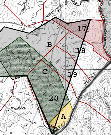
B. Deed 1-162, Cabarrus NC, 19 Jul 1793, prv’d ---. Andrew Alexander, Late Sheriff of Mecklenburg, to William Polk of Cabarrus. Being 499 acres on the “west side of Rocky River between Clear Creek & Muddy Creek and between the Charleston Road and the river. The metes and bounds are from a p.o. (on his old line and runs with Charles Polk’s line) north 25 west 216 to small b.o., south 66 west 66 to pine, north 40 east 90 to hic., south 80 east 140 to pine (near William Bugg;s line), north 58 east 96 to p.o., south 70 east 48 to pine, north 83 east 60 to pine (Thos. Polk’s corner), then with said line to begin. Wit: John Froman. Jurat: Paul Barringer
C. Deed ____, Cabarrus NC, 16 Jan 1816, prv’d Apr 1825. John McLellan, Esq. to George Cagle. Being 170 acres on the west side of Rocky River & the Charleston road. From an execution issuing from the Cabarrus Superior Court against Elisha Spiers for $640 recovered by the President of the State Bank of North Carolina. The metes and bounds are from a b.o. (on the side of the road, Charles Polk’s corner & runs with his line) east 128 to stump (in an old field his other corner), (with his other line) south 26 east 180 to stake (on the river bank), (up the river) north 43 w 24 to hic. (George Kizer Jun’s corner at the mouth of the branch), (with his line) north 52 west 40 to stake, north 36 east 120 to p.o. stump, north 22 west 126 to pine, north 55 west 186 to pine, south 26 west 130 to hic. (on or near Charles Polk’s line), (with Charles Polk’s line) to begin. Wit: R. McLellan, Rosannah McLellan.
21. Deed 19-505, Mecklenburg NC, 27 Oct 1785, prv’d Jul 1809. William Polk to Charles Polk Senior, being 243 acres on the north side of Rocky River on both sides of the big run. The metes and bounds are from a b.o. (south side of the run near the head of a spring) north 20 east 140 to p.o., east 40 to p.o., south 7 east 135 to p.o., south 26 east 200 (crossing the run) to b.o. & s.o. (on the rivr bank), (down the river) south 43 west 24 to l.o., (on bank, Freeman’s corner), (with Freeman’s line) north 71 west 58 to pine (near path), north 88 west 220 to b.o. (Freeman’s other corner), then to begin. Wit: M Polk, James Kennedy.
6101 Ballou Court
Raleigh, North Carolina
27609
/font size> Copyright © 2009 by George G. Thomas
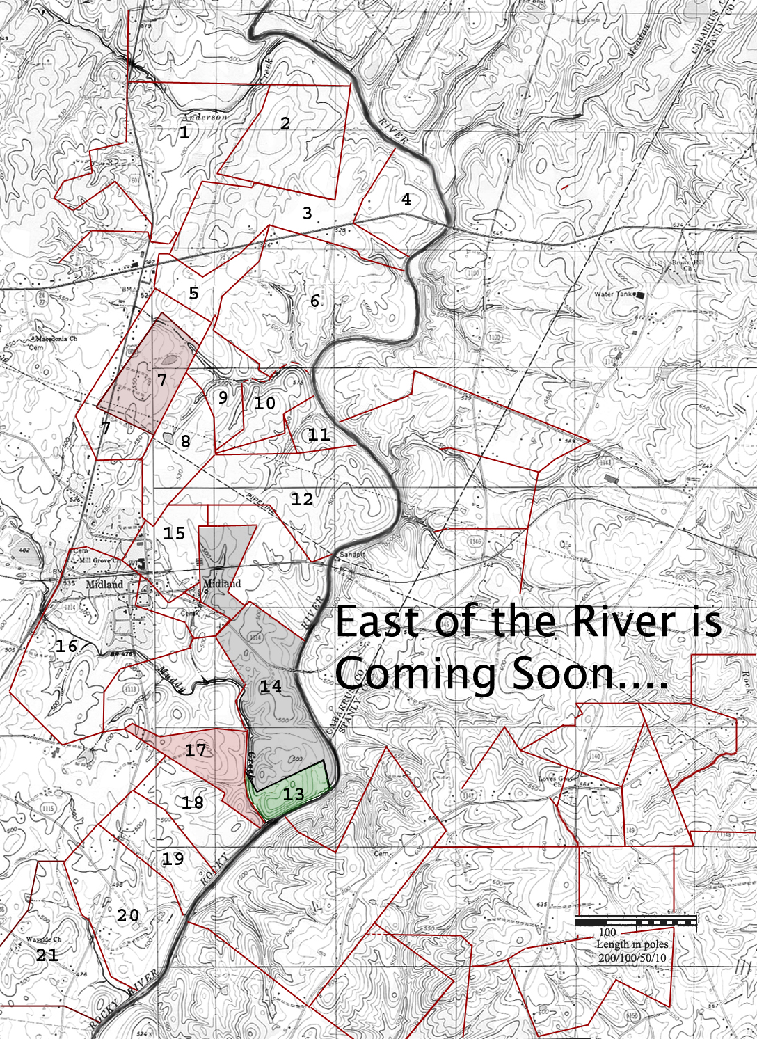
Tax Map for Lands in Cabarrus County
Tax Map for :ands in Stanly County