1. Deed (Division) 24-170, Cabarrus NC, Spring term 1839. Division of the lands of Frederick Kizor dec’d among the heirs at law viz: Moses Kisor, Polly Yow, Susanna Yow, Rachael Kisor, Milly Edmunston, Fanny and Cheek.
2. Grant # 1729, Montgomery NC, ent. 8 Apr 1803, sur. 5 Mar 1805, iss. 16 Mar 1805. Issued to Henry Kagle, being 145 acres “on the Camp branch of Rocky River including his own improvements.” The metes and bounds are from a pine and oak (his own old corner) south 52 east 140 to r. o. and p. o., north 38 east 170 to hic. and pine, north 52 west 140 to three r. o. (on his own old line), then to begin. CC: Anderson Freeman, Dennis Clay.
3. Deed 9-80, Stanly NC, 16 Apr 1862. Rody Kittle to Edmond Taylor, being 100 acres. The metes and bounds are from a b.g. / p.o. (Laban Little’s corner, running with his line) north 85 west 6 ch 75 lks to w.o. / 2 p.o. (his corner in a drain), (his line again), south 5 east 16 ch 60 lks to p.o. (his corner, near the edge of a field), north 62 west 33 ch to stake / p.o (at the crossroad), (with Levi Furr’s line) north 15 west 40 ch to p.o. / p.o. / r.o., (with his line again passing his corner) north 21 east 19 ch 50 lks to b.o. / p.o. / w.o. (on Rody Kittle’s line), (with his line) south 50 east 35 ch 50 lks to stake / dog, south 13 ch (with Jacob W. Little’s line) to w.o. / pine (his corner), west 4 ch 75 lks to p.o (near the springs said J. W. Little’s corner), south 17 ch to begin.
4. Deed 5-137, Stanly NC, 17 Oct 1848. John Vanderburg ot Stanly to Moses Furr of Cabarrus. Being 280 acres beginning at a syc (on Rocky River) north 3 west 240 to po (James Little’s corner), south 88 west 225 to wo on Rocky River, then (down the river) to begin.
5. Deed 1-214, Stanly NC, 25 Jan 1844. John Vanderburg to James Little. Beginning at a pine on Rocky River (opposite an island) north 85 west 32 to pine, west 36 to gum and pine, north 3 east 160 to forked pine (in drain), north 60 west 30 to po, south 88 west 100 to po, south 3 east 240 to syc (on Rocky River), then down the river to begin. Wit: Sam’l W. Rodgers, John Little.
6. 26 Dec 1883 W. L. Green to to A. E. Green, being 125 ˝ acres adjoining Moses Furr and Thomas Love on the west side of Camp Branch.
6A. Stanly County, 15 Nov 1869. E. A. Osborn (Clerk of Court for Mecklenburg) to Thomas Love, Known as Lot # of the lands of Labon Little adjoining Jacob Little, Margaretta Little, Jonah F. Little and Thomas Love.
B. To Emily Edmunston, being 83 acres.
C. To Moses Kisor, being 80 acres.
D. To Susan Yow, wife of Christopher Yow, being 76 acres.
E. To Rachael Kisor, wife of David Kisor, being 84 acres.
F. To Fanny Cheek, wife of Elisha Cheek, being 113 acres joining Vanderburg to the south.
A. Grant # 1730 Montgomery NC, ent. 8 Oct 1804, sur. 10 Mar 1805, iss 13 Apr 1805. Issued to David Carr, the warrant is for 221 acres “on the Camp branch on both sides of the old road leading from Charlotte to Fayetteville crossing Rocky River at Polk’s ford beginning at a oak Hill Weatherford’s corner near a spring on the west side of Camp Branch.” The metes and bounds are from a p. o. (Hill Weatherford’s corner near a spring on the west side of said branch) west 20 to stake, north 270 (crossing the old road leading from Charlotte to Fayetteville, east 135, south 270 (crossing said road), west 115 to begin. CC: Arthur Taylor, Cunningham Harris.
B. Deed 13-801, Mecklenburg NC, 12 Dec 1789, prv’d Jul 1790. William Piron to William Polk Senior. Being 24 acres on the Rocky River, the metes and bounds are from a b.o. (on the bank of the river) north 34 east 40 to pine, south 13 west 128 to pine, west 16 to elm (on the river), along the river to begin. Wit: Wm. Polk.
C. Deed 1-30, Cabarrus NC, 8 Jun 1792, prv’d Jul 1793. William Pyron of Mecklenburg to Frederick Kyzer of Mecklenburg. The metes and bounds are from a w.o. south 24 east 28 to p.o., south 52 east 112 to pine, south 112 to b.o (by Cross Creek Road), west 84 to stake, north 3 east 128 to pine, south 84 west 41 to b.o. (on the river bank), then up the river to begin. Wit: Hilkiah Westherford Jr., Thos. Polk.
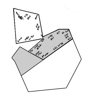
D. Grant # 0124, Montgomery NC, ent. 6 Jan 1801, sur. 1 May 1801, iss. ----. Issued to Hilkiah Weatherford, being 365 acres on Rocky River this tract was issued by virtue of two warrants. Though slightly different in shape, this grant is much of the same land included in the western end of James Love’s grant # 083 which follows. Entered five days after James Love’s entry was surveyed, note there is no issuance date given for either tract. The metes and bounds are from a pine (his own corner in Fredrick Kiser’s line, running with his line) north 80 east 102 to b. o. (his corner), north 72 east 185 to p. o. (in Carson’s line), (with Carson’s line) south 60 east 146 to 2 pines (his corner), (with his other line) south 30 east 120 to r. o. & pine & dog, south 72 west 16 by r. o. & pine, north 40 west 8 to r. o. (McGehee’s corner), south 80 west 34 to stake (on the river bank), (up the river) north 60 west 15, north 70 west 23, south 80 west 27 to stake, south 48 west 80 to pine (corner), south 80 east 32 to sas (on river bank), (up the river to his corner of his old tract) to a w. o., (with his line) north 19 west 70 (to his corner), south 83 west 90, south 8 west 8, north 53 west 130, then north 30 west to begin. CC: Fredrick Kiser, William Weatherford.
E. Deed 1-28 Cabarrus NC, 7 Feb 1793, prv’d Jul 1793. William Polk of Cabarrus to Hilkiah Weatherford of Mecklenburg. Being 73 acres on the northeast side of Rocky River. The metes and bounds are from a w.o. (on the bank of the river) north 19 east 70 to b.o., south 83 west 90 to b.o. and pine, south 8 west 8 to pine (the old station corner), north 53 west 130 to old dead pine, north 30 west 20 to pine (Frederick Kyzer’s corner), west 19 to elm (on bank of river), then up the river to begin. Wit: Frederick Kyzer Jr., Wm. Weatherford.
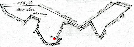
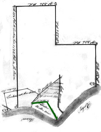
D and F. Grant # 083, Montgomery NC, ent. 8 Jan 1800, sur. 1Jan 1801. iss. ---. Issued to James Love, the warrant for this tract is 500 acres “beginning on McCasson’s line near the County line between Montgomery & Cabarrus and including all the vacant land between his land and the river joining to James Phillip’s land.” Grant # 0124 above included much of the western portion of this tract. In comparing the descriptions, the other tract adjoins Frederick Kiser’s land. Also, James Love’s survey identifies the mouth of Camp Branch (red dot) while Hilkiah Weatherford’s does not. Drawn up to be 460 acres, the metes and bounds in the survey are from a p. o. & r. o. & p.o. (in Carson’s line and runs with Thomas Macgehee’s line) south 24 east 37 to pine (his corner), (with Henry Frederick’s line ) south 58 east 146 to (Philip Frederick’s line), (with Frederick’s line) north 50 east 58 to pine (his corner), south 63 east 70 to r. o. (Frederick’s beginning corner), south 17 west 60 to p. o. (Frederick’s corner), south 25 west 14 to ced. & map. & w. o. (on river bank), (down the said river south 27 east 92 to a syc. & ash (on bank of river) south 40 east 16 to stake, south 72 east 50 to stake, north 80 east 12 to stake, north 52 east 8 to w. o. & ash & map. & s. g. (at mouth of Camp Branch), (up said branch) north 78 west 24 to stake (Hathcock’s corner on bank of branch), north 30 east 128 to p. o. (his corner), north 85 east 35 to stake, south 60 east 102 to stake, north sixty east 78 to stake, south 25 east 122 to stake (said Hathcock’s corner on the river bank), north 35 east 90 to stake, north 55 east 202 to pine (Carson’s corner on river bank), north 70 west 100 (to his other corner), south south 60 west 280 to pine (his corner), north 60 west 328 to p. o. (his corner), west to begin. CC: Thomas Love, Henry Frederick.
G. Grant # 0140, Montgomery NC, ent. 9 Aug 1799, sur. 29 Apr 1801, iss. ---. Entered and surveyed for Jno. Pyron, this 100 acre tract is located on Rocky River adjoining Camp Branch, his own, and Sampson Dunn lands. Shaded in gray, the tract fits perfectly the larger void in the southern end of James Love’s grant # 083 above. On 1 Apr 1801, at the time when Love’s land was surveyed, the owner of land in this void was identified as “Hathcock.” The metes and bounds are from a p.o. (supposed to be in Sampson Dunn’s line) north 85 east 35 to stake, south 60 east 102 to stake, north 60 east 78 to stake, south 25 east 122 to stake (on bank of river), (up the river) north 77 west 30 to s. g. (his corner on river bank), north 44 west 68 to hic. (his corner), north 31 west 22 to (his other corner), south 80 west 68 to w.o. (his corner), south 24 to (his beginning corner), up the river south 85 west 152 to stake (on the bank of Camp Branch), north 30 east 128 to begin. CC: Samson Dunn, Joshua Williams.
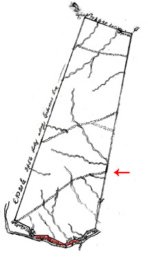
Grant ………… Being 26,880 acres issued to Barnabus Dunn, Thomas Carson, and William Moore. This tract runs the county line from Rocky River north to past Pole Bridge Creek. These three men also received grants for several other tracts encompassing a majority of the lands in now Stanly County NC. Three roads cross this tract. Along the north and running east to west, Paul’s wagon road connected the Dutch Wagon road with the Fayetteville Highway. And running northeast from Polk Ford in the big bend in Rocky River, the Fayetteville, also known as Polk’s road (see red arrow) connected Charlotte to Fayetteville. Today this road is known as Polk Ford Road, passing by both Love’s Grove and Love’s Chapel UMC. To show perspective, James Love’s 460 acre grant (as follows next) is highlighted in red along the southern bounds of this tract. The metes and bounds are from a r. o. (near Conrad Woody’s line on the waters of Bear Creek) south 11 west (along Carson and Moore’s line) 3,736 to gum (their corner on Rock Hole Creek), south 80 west 130 to pine, south 40 west 208 (crossing a branch) to pine (on Rocky River), north 70 west 100 (crossing a branch twice) to pine, south 60 west 200 (crossing the Camp Branch) to pine, north 60 west 328 (crossing Middle Camp Branch) to p. o., west 240 to hic. (on Rocky River in Thomas McGhee’s line), north 30 west 160 to pine, north 60 west 280 to (the County line), (along the line of Cabarrus County) north 20 east 3,656 to w. o., south 70 east 620 (crossing Running Creek and Pole Bridge Creek) to pine (Thomas Motley’s corner), north 70 east 216 to begin. CC: Andrew Bankston, James Bankston.
7. Deed 7-157, Anson NC, 10 Apr 1779, prv’d Oct 1779. David Oliphant by his attorney Thomas Polk of Mecklenburg to Thos. McGehee. Shaded darker red, the metes and bounds are from a pine (noth side of the river) south 84 east 50 to b.o. (across the creek, south 46 east 160 to gum (Phillip Frederick’s corner), north 30 east 74 to pine, north 24 west 126 to p.o., then to begin. Wit: Philip (P) Fredrick, James (I) McGehee.
Deed M-111, Anson NC, 18 Jul 1803. Benjamin Mcgehee of Anson to Christopher Clounts of Cabarrus. Being 50 acres, I believe this is that portion of the above land located on the south side of Rocky River. The metes and bounds are from a b.o. in o p m Creek, thence north 46 east 160 to the river as the old line runs, then with the river to begin. The direction of the line in this transaction changes from running southeast to now northeast. Wit: Jeremiah Clountz, Jeremiah Clountz Jr.
8. Grant # 1567, Montgomery NC, ent. 10 Jul 1799, sur. 29 Apr 1801, iss. 20 Aug 1802. Being 50 acres issued to Henry Fredrick. Shaded light red, the metes and bounds are from a pine (in his own line, running with his own line of his other tract) north 50 east 66 to stake, north 58 west 156 to pine (Magehee’s corner), south 30 west 63, south 58 east 125 (with his line) then to begin. CC: John Fredrick, Sampson Dunn.
9. Deed K-3, Anson NC, 5 Feb 1771, prv’d Feb 1771. Abner Nash and wife Justina to John Polk, being 70 acres lying in a tract called the Welsh Tract. The metes and bounds are from a b.o. (on the north side of Rocky River) south 33 west 32 to s.g (on bank of river), south 47east 30 to hic., south 8 west 60 to w.o., south 66 east 90 to pine, north 39 east 30 to hic., then north 58 west 154 to begin. Wit: Clement Nash.
10. Grant 3750, Anson NC, ent. 16 Jan 1773, sur. 18 Jan 1774, iss. 28 Feb 1773. Issued to Henry Eustace McCulloh, this is but one of numerous grants issued to McCulloh at this time. Most were for land on the north side of Rocky River near mouth’s of several creeks. Most of the grants indicate that others live or have lived on the land. I suspect McCulloh was acquiring lands out from under people who lived on land without proper title of ownership. This enabled him to sell off, without question, large blocks of land in what was known as Tract #2. The legal description for this piece of land reads: “fifty four acres of land in Anson County on the no. side of Rocky River including Burlison’s old place.” The metes and bounds are from a hic (on the bank, and running thence with new lines) north 13 east 100 to w.o., south 77 east 120 to b.o. (on the bank of the river), then (with the river) to begin.
11. Grant # 7, Stanly NC ent. _____, sur. 21 Feb 1842, iss. _____. Issued to James Little Junior, being 31 acres adjoining James Little Senr. and the land belonging to the heirs of George Tucker deceased. From the survey, the land crosses over “Little Camp Branch” at its mouth. This is the mouth of present day Pumpkin Branch. The next plat (from Stanly County ejectment papers) also locates the mouth of this creek. Adjoining the tract to the east, grant # 1802 to Stokes Pinion indicates this grant to James Little was once land held by David Burleson. The metes and bounds are from a dead pine (said Tucker’s corner of the 100 acre tract & runs with a line of said tract) south 10 east 25 ch to the river, (up the river) to (James Little Senr’s corner) Sycamore, (with Little’s line) north 80 east 16 ch to (his corner in Little Camp branch), north 20 west 22 ch to small b. g. by pine, north 80 east 8 ch 50 lk to small r. o. by two pines, then to begin. CC: Rubin Pinion, Olemsted Little.
12. Grant # 1802, Montgomery NC, ent. 7 Oct 1806, sur. 15 Dec 1808, iss. 7 Oct 1809. Issued to Stokes Pinion, being 100 acres on Rocky River, “Beginning at the turkey rust tract.” The warrant is for land “joining David Burleson’s line and the Turkey Rust tract & between the same.” The metes and bounds are from a p.o (on the bank of the river, the beginning corner of the turkey rust tract) north 26 (with said turkey rust tract) to p. o., north 40 east 70 to stake, then north 65 west 75 to p. o. (corner on Love’s line) then with said line (south 82 west 146 to pine and three pine pointers (one of said Love’s corners), (with said love’s line) south 10 east 100 to small cedars and three hic. pointers (on bank of river), then down the river to begin. CC: Peter Long, George Tucker.
13. Grant # 1801, Montgomery NC, ent. 4 Jan 1809, sur. 11 Apr 1809, iss. 4 Jun 1809. Issued to Reuben Pinion, being 26 acres on the north side of Rocky River. Adjoining Grant # 1802 to the east, this must be what is identified as “the turkey rust [roost] tract. The metes and bounds are from a p. o. (on bank of river, Stokes Pinion corner, running with his line) north 2 east 25 to p. o. (his other corner), (with his line) south 88 east 87 to stake (in Love’s line), (with his line) south 30 east 106 to a stake (on the river, Love’s corner), then up the river to begin. Note that ca. 1808, the land north of this and grant # 1802 above were owned by “Love.” CC: Wm. Hinson, Jordan Drake.
14. Grant #8, Stanly NC, ent. 25 Oct 1841, sur. 23 Feb 1842, iss. 8 Mar 1842. Issued to Leonard Green Jun’r, being 100 acres on Rocky River “adjoining James Little Ser. & the land of George Tucker Dec’d. As illustrated above in the plat for Green vs. Smith, Leonard Green evidently entered this tract on lands held or once held by George Smith. And in ca. 1808, the survey for Reuben and Stokes Pinion tracts indicates at that time the same land was held by “Love.” The metes and bounds are from a stake and three pines (a corner of said Tucker’s 100 acres tract ) north 53 east 39 ch to stake (in Lick Branch), down various courses of said branch to Rocky River, up various courses of said river to a stake (on the river bank, George Tucker Dec’d corner of the 26 acre tract). (with a line of said Tucker’s 26 acre tract) north 29 west 29 ch to a stake (in a field), (another line of said tract) west 21 ch 75 lks to (his) p. o. (also a corner of the said Tucker’s 100 acre tract, then (with a a line of said 100 acre tract) north 40 east 17 ch 50 lks to begin. CC: Caleb Osborne, Joshua Osborne.
Found in loose ejectment papers filed in relation to land disputes in Stanly County, the survey above represents for the plaintiff Leonard Green, his 100 acre Secretary of State land grant adjoining Lick Branch and George Tucker’s 100 and 26 acre tracts. The much larger rectilinear shape represents 670 acres owned by the defendant George Smith as described in deed _____ above. George Smith’s land appears in shape and size to be rooted in the subdivision of Governor Dobb’s Great tract. In an early Colonial move to manipulate the migration of settlers to western NC, The Governor Arthur Dobbs and others purchased 12 large tracts of 100,000 acres each. Speculators of land were then encouraged to buy tracts in required size of 1,900 acres or more for the purpose of resale. After the death of Arthur Dobb’s, a petition in 1778 created a means in which the Secretary of State was allowed to issue grants in smaller amounts from all the vacant lands. And as luck would have it, in 1794, speculators Thomas Carson, William Moore, and Barnaby Dunn received land grants built on hundreds of warrants equaling nearly 60,000 acres that covered much of present day Stanly County. The surveys for these tracts uniquely identify both the lands within and bounded by the grant. The plat and legal description does not account for this large acreage owned by George Smith. George’s tract may therefore be a later subdivision of the lands of Carson, Moore, and Dunn.
Responsibility falls on the grantee to verify that land to be granted is vacant and available. However, looking at the plat to the left, the two Tucker tracts were originally granted by the state to Stokes and Reuben Pinion.
In evidence of the life and this land said to be owned by the above mentioned George Smith, the following deeds are found in Stanly County:
Deed 1-230, Stanly NC, 12 Oct 1830, prv’d 21 Nov 1844. Jesse Smith of Campbell County GA to George Smith of Montgomery County NC.
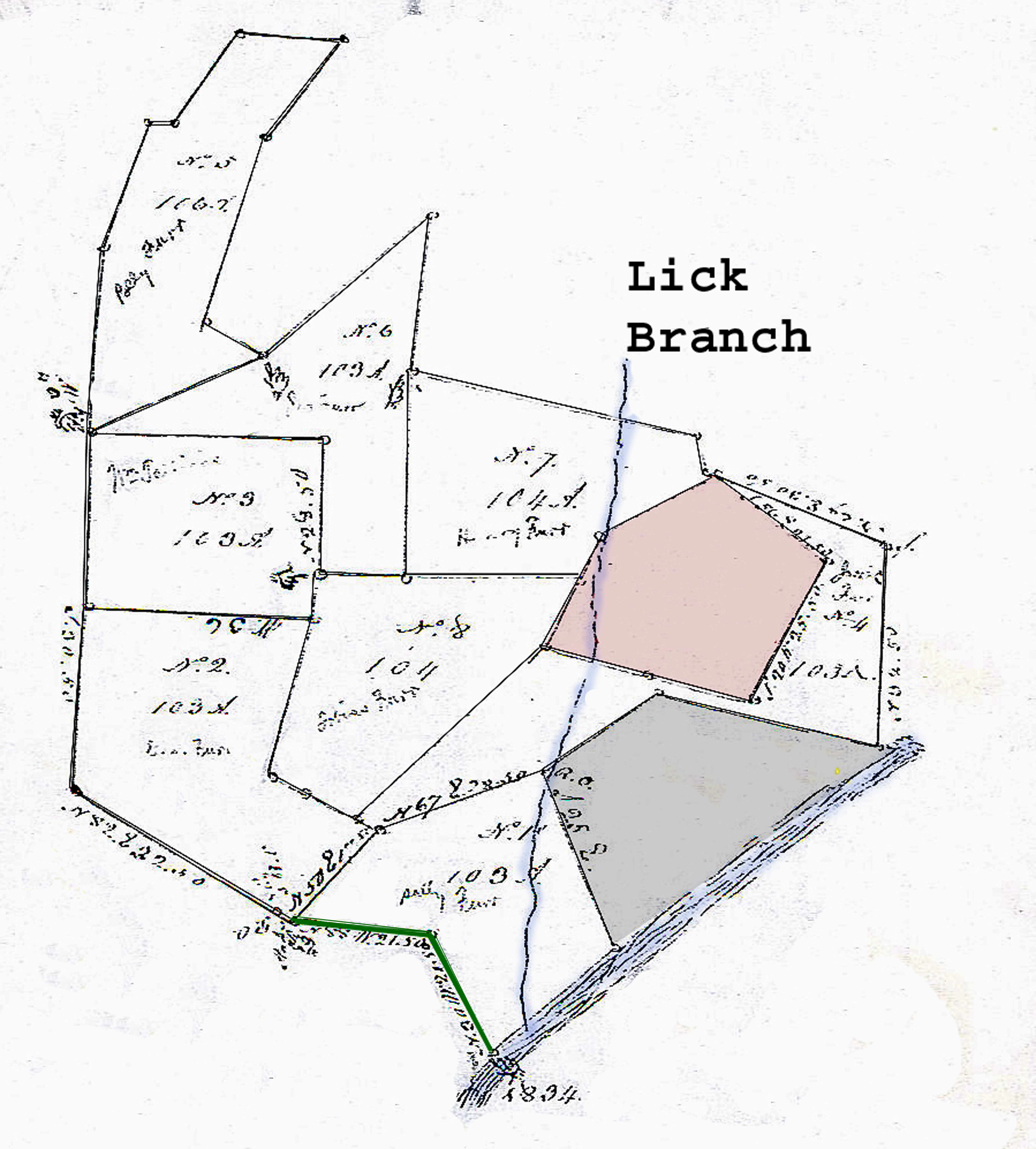
The plat above locates the Montgomery County estate lands of John Furr deceased as appears in Deed 14-39&40, Cabarrus NC, 22 Feb 1834. From the division legal description, the gray shaded tract is owned by Leonard Hartsell and the red shaded tract is owned by Thomas Pinion. The legal description for Thomas Pinion’s land is: Grant 2173, Montgomery NC, 1817 issued to Thomas Pinion. Beginning at a pine (in Brooks’ line) south 58 east 85 (with Brooks’ line to po (John Brooks’ corner), south 20 west 100 to po, north 83 west 68 to po, north 75 west 68 to pine, north 20 east 76 to hic, north 60 east 84 to begin. The legal description for John Furr division is as follows::
Viz. No. 1 to Sally Furr, one hundred and three acres estimated to be worth one hundred and three dollars courses and distances are, beginning at a sg (on the bank of Rocky River) North 30 west 21 chains and fifty links to a stake by some dog pointers, (with George Tucker's line) north 88 degrees west 21 chains and 50 links to po, north 40 degrees east 17 chains and 50 links to a stake by pointers, then north 67 east 28 chains 50 links to ro (on Lick Branch - Leonard Hartsel's corner), (with said Hartsel's line) south 25 east to a stake (on the bank of Rock River), thence up the various sources of said River to begin.
No. 2 to George Furr, beginning on a stake by 3 ro north 23 chains and 40 links to a po by 3 ro, due W. 36 chains to a pine & po, due S. 30 chains and 50 links to a stake by pointers, (Geo. Tucker's line), (with said Tucker's line) north 82 degrees east 32 chains and 50 links to po, then south 65 east to begin.
No. 3. to Wm Tallions (Stallings) 103 acres beginning at a po by 3 ro ( second corner of the 2nd division due north (to and with No. 6) 28 chains and 50 links to a pine by 2 po, due west 36 chains to a stake by four po, due south 28 chains and 50 links to a pine and po (third corner of No. 2), (with a line of said #) east 36 chains to begin.
No. 4. to Jacob Furr 103 acres beginning at a ro (on Lick Branch, Leonard Hartsel's corner) north 64 east 21 chains and fifty links to a stake by pointers (his corner), south 78 east (to the intersection of said Hartsel's and Furr's line), (with Furr's line) due north 35 degrees chains to a po (on Honeycutt's line), ( with said line) north 63 W. 28 chains and 50 links to a pine, (Thomas Pinion’s corner), thence his line south 56 degrees east 21 chains and 50 links to a po (the beginning corner of said Pinion’s line), (with the first line to said tract) south 20 degrees W. 25 chains and 50 links to po, north 33 degrees west 17 chains to another po, north 75 west 17 chains to a fallen pine (a corner of No. 8), ( with a line of No. 8) north 45. 30 west 41 chains and 50 links to a stake by 3 po, S. 65 E 4 chains to a stake by pointer (a corner of No. 1), ( with a line of said) west 67 east 28 chains and 50 links to begin.
No. 5 to Polly Furr 106 acres beginning at a stake by po and pine north 60 west 8 chains and 50 links to a pine (on the side of the road), north 15 degrees east 30 chains and 50 links to a stake, north 35 east 20 chains to a stake and pointers, due west 17 chains to po (John Little's corner. thence his line S. 31 degrees N. 17 chains thence south 77 west 4 chains to said Little's corner), (with his line) south 11 west 17 chains and 50 links( to the intersection of said Little's and John Furr dec'd line), due south 29 chains to a stake by four po (a corner of No. 3 and No. 6), (with a line of No. 6) north 64 east 30 chains to begin.
No. 6 to John Furr 103 acres beginning at a stake by 4 ro (last corner of No. 5 and runs with the last line of said division) north 64 east 30 chains to (the beginning corner of said division), north 47 degrees E. 35 chains to a hic (George Tucker's corner), (with his line) south 3 west 26 chains to a dead pine by pointers( a corner of No. 7), due south 32 chains to a stake by 3 po, due west 15 chains to a stake by 3 ro (a line of No. 3), ( thence with said line) due north 21 chains and 50 links to (the corner of said No.), due N. 36 chains to begin.
No. 7 to Henry Furr beginning on a dead pine by pointers (George Tucker's corner and with his line) south 80 east 46 chains to a pine (his corner), (with Eli Honeycutt's) south 13 E. 6 chains to ( his corner) pine, (with his other line) south 69 degrees east 45 links to Thomas Pinion’s corner), (with his line) south 60 west 21 chains to hic (on the W. side Lick Branch), south 23 west 7 chains to a stake by 2 ro and hic, due west 27 chains to a stake by 3 po (a corner of No. 8), then (with a line of said No.) due north 32 chains to begin.
No. 8 to Tobias Furr 101 acres beginning a stake by 3 po (on a line of No. 3 and a corner of No. 6) due east 42 chains to a stake by 2 ro and hic (a corner of the 7th division on Pinion's line), (with his line south 23 degrees west 11 chains and 20 links to a fallen pine, south 45.30 west 41 chains and 50 links to a stake by a pine and small hic (and corner of No. 4), north 65 west 8 chains and 50 links to a stake by 3 ro, (a corner of No. 2), then due north (with a line of said No. 8 passing the corner 36 chains) to begin.
19. Grant # 2888, Montgomery NC, ent. 3 Sep 1838, sur. 12 Dec 1839, iss. 23 Dec 1839. Issued to James Little, Senr., being 100 acres adjoining his own lands on Rocky River on the northeast side of where he lives. The metes and bounds are from a s. o. north 50 east (with said Little’s line) 14 ch 50 lk to pine (his corner), south 66 east 12 ch 50 lk to p. o. (on the west bank of Camp Branch), north (up Camp branch) 9 ch to pine by pine and p. o., north 62 west 23 ch to small b. o. by pointers, north 75 west 44 to p. o., south 23 east 20 ch to fallen down pine (his old corner), then to begin. CC: James Little Jr., Aaron Little.
20. Grant # 2895, Montgomery NC, ent. 4 Mar 1839, sur. Dec 12 1839, iss. 28 Sep 1840. Issued to James Little Senr, being 180 acres adjoining his former entry on Camp Branch. The metes and bounds are from b. g. by a hic. north 75 west 10 ch to dog by large b. o. and hic., south 30 west 15 to p. o., south 80 west 4 ch to dog, south 35 west 19 ch 50 lk to stake, north 75 west 27 ch 50 lk to dog, south 23 east 6 ch 50 lk to p. o. (a corner of James Little Sr. former 100 acre entry), (a line of said entry) south 75 east 44 ch to small b. o. (a corner of said entry), (with another line) south 62 east 23 to pine by p. o., north 4 east 13 ch 50 lk to pine, south 82 east 12 ch 50 lk to pine (said Little’s old corner), north 19 east 10 ch to p. o. (in a branch), north 75 west 4 ch 50 lk to pine by b. o., north 15 east 15 to dog (on east bank of Camp branch), then to begin. CC: James Little Jr., Aaron Little.
21. Grant # 2885, Montgomery NC, ent. 9 Mar 1838, sur. Dec 13 1838, iss. 26 Sep 1839. Issued to Labon Little, being 76 acres adjoining George Smith and James Little Ser. The metes and bounds are from a p. o. (James Little Sr. corner), (with his line) south 19 west 10 ch to pine (his corner), south 82 west 12 ch 50 lk to pine, south 4 west 13 ch 50 lk to pine, (down the Camp branch) south 3 west 9 ch 20 lk to p. o. (on west side of branch), south 66 east 7 ch 50 lk to stake by three pine, south 76 ch 50 lk to r. o. by hic., south 80 east 15 ch to p. o., north 15 ch to pine (on top of hill, north 50 east 10 ch to pine, north 5 west 14 ch 50 lk to small r. o. by large pine then to begin. CC: Moses Kizer, Christopher Yow.
23. Grant # 9, Stanly NC, ent. ______, sur. 23 Feb 1842, iss. ______. Issued to Duncan Tucker, being 100 acres on the Rocky River adjoining James Little Senr and Moses Osborne. The metes and bounds are from a fallen pine (Moses Osborne’s corner) north 80 west 37 ch to stake, south 34 ch to stake (in line of George Tucker Dec’d 100 acres tract), (with reverse) south 65 east 10 ch to stake (a corner of said 100 acre tract & beginning corner of Leonard Green’s entry & runs with said Green’s line), north 53 east 39 ch (to his corner) stake, north 6 east 7 to Moses Osborne’s line, then to begin. CC: Caleb Osborne, Joshua Osborne.
24. Grant # 10, Stanly NC, ent. ________, sur. 23 Feb 1842, iss._______. Issued to John Green, being 100 acres adjoining Moses Osborne and the land of George Tucker deceased. The metes and bounds are from a fallen pine (Moses Osborne’s corner and the beginning corner of Duncan Tucker’s entry), (with Osborne’s entry) north 25 east 14 ch 60 lk to (his corner) (on a branch), (up various courses of branch) to haw tree (in branch on George Tucker deceased line), south 78 west 44 ch to stake, south 16 ch 70 lk to stake (a corner of Duncan Tucker’s entry), (With Tucker’s entry) south 80 east 37 to begin. CC: Caleb Osborne, Joshua Osborne.
25. Deed 21-342, Stanly NC, 3 Nov 1888. JL Little & J. M Green, Exe. of John Green dec’d to A. W. Green. Beginning at a maple on the bank (Wm. Whitley’s) north 3 ˝ east 71 tp stone (Whitley’s), south 78 ˝ east 115 ˝ to mouth of old branch), north 15 east 40, north 10 west 46 to stone on old line, north 28 east 12 ˝ to stone, south 42 east 138 to stone (old line), south 18 west 45 ˝ to po and pine, south 88 west 105 to stone (north of ford), south 13 east 8, then north 72 west 98 to begin.
26. Deed 12-306, Stanly NC, 11 Mar 1879. John Green to son A. W. Green. Being 88 acres beginning at a stone north 18 east 88 tp stone & 2 po (in branch), north 36 east 46 to stone (in road), north 13 east 36 to stone (in road), south 88 west 78 ˝ to pine, north 58 west 30 to dog (Joseph M. Green corner), supposed south 28 west 100 to stone & ced & per, then south 42 east 138 to begin. Wit: W. T. Howell, J. W (x) Little.
27. 15-496, Stanly NC Benjamin Pinion and wife to George Tucker, beginning at dog south 3 ˝ east 64 to po, north 77 west 86 (with George Tucker) to po, north 16 east 50, north 27 east 10 ˝ , north 12 east 30, north 36 east 18, north 57 east 50 to stake (on the road), south 1 west 72 to begin. This tract makes up the northwest corner of the following deed from Duncan Tucker to H. A. Tucker. Wit: J. C. Drake.
28. Deed 17-235, Stanly NC. Leonard G. Tucker and wife Frances of Greene County Arkansas to Jonah E. Tucker. Beginning at a bo north 55 east 120 to hic (D. F. Mann corner), north 13 west 80 to sas (near the road), west 160 (crossing two roads at the forks) to po & 2 po, south 98 to 2 pines (in Green’s line), east 36 to ro (on side of road), south 36 to pine (on side of road), south 36 west 28 to ro (in John Green’s line), north 85 east 68 to begin.
Deed 10-442, Mecklenburg NC, 10 Jan 1780. John Polk to Allen Freeman. Being 4 tracts of land:
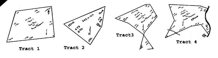
Tract 2: Containing 35 acres, the metes and bounds are (joining the former survey of said John Polk, and beginning at the west corner of said former survey) north 9 east 58 to pine, south 65 west 124 to pine, south 53 east 94 to hic. (on or near the other line of said John Polk), (then (along the same) north 29 east 57 to begin.
Tract 3: This tract does not close and the lines actually cross over each other. It nests nicely under tract 4 and appears to mate up to the northwest corner of tract 1. It appears the number 83 or 38 in one of the two surveys has been mistakenly transposed affecting all four tracts. For this tract, it is 125 acres with metes and bounds from a pine north 13 east 60 to w.o., north 3 east 112 to ash, north 30 west 80 to hic., due west 24 to b.o., west 190 to b.o., south 70 east 82 to p.o., south 83 east 100 to w.o., south 30 east 104 to stake, then south 83 west 34 to begin.
Tract 4: Containing 270 acres, the metes and bounds are from an ash (the said Polk’s original corner) north 30 west 90 to hic. (of resurvey), south 80 west 68 to stake, south 65 west 200 to p.o. (crossing the creek to Charles Polk’s corner), north 29 east 140 (crossing the creek) to p.o. (another corner of said Polk), north 19 west 120 to B.O.m south 88 east 220 to pine, south 71 east 58 to l.o., then down the river to begin. The western end of this tract was later set aside as widow’s dower for Barbara Freeman. Her dower, and this tract were later sold to James S. Russell. See below:
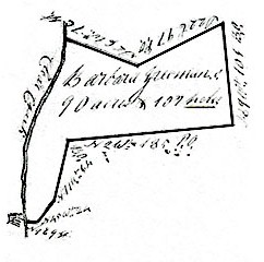
Deed 19-311, Mecklenburg NC, 27 Apr 1821, prv’d ____. Isham Freeman of Lancaster SC sold to James S. Russell of Mecklenburg. Being 300 acres on Rocky River including the widow’s division. Wit: ________.
The following deeds partially chronicle the break-up of great tract #2, being one of 12 great tracts owned by Henry Eustis McCulloch & Company. This 18,000 acre subdivision lies on the south side of Rocky River and runs closely with the old Anson-Mecklenburg county line. On map 5, this tract encompasses every bit of the land south of Rocky River and east of the Anson-Mecklenburg county line. The western boundary line of this tract likely played a major role when choosing the location for running the dividing line that originally formed Mecklenburg County.
Deed 123, Anson NC, 29 Apr 1796, 29 Apr 1796. John Winslow of the town of Fayetteville in the county of Cumberland to Daniel Wheaton of Fayetteville, merchant. Being 18,000 acres granted from his Majesty George the second to Arthur Dobbs. Wit: Duncan McRae, Jesotestu.
Power of Attorney G-46, Anson NC, 17 Apr 1799, prv’d Apr 1799. William Cupples & William Johnson appoint John Wright Jur. power of attorney to sell any part of the large tract situated below the mouth of Goose Creek joining the county line and Rocky River. Wit: D. Cuthbertson. Deed U-303, Anson NC, 12 Jan 1823, prv’d Apr 1823. Joseph Medley, high Sheriff of Anson County to William Johnson. Whereas the Andrew Polk. Late Sheriff seized a certain tract of land supposed to be “the property of William Johnson and the heirs of William Cupples and the heirs of John Wright dec’d,” containing 16,000 acres. The legal description indicates the tract to be 14,154 acres. Wit: A. Little, W. Dismukes.
34. Deed 15-251, Mecklenburg NC, 26 Oct 1795, prv’d Jan 1797. George Graham Esq., late sheriff of Mecklenburg to Jeremiah Clontz. The metes ad bounds are from a pine (on his own line & on the county line & runs with the county line) south 3 east 220 to b.o., south 64 west 14 to p.o., north 75 west 60 to p.o., north 26 west 106 to hic. (on Long’s line), (with his line), north 14 east 18 to small hic., south 75 east 9 to pine (his own old corner), then (with his line) to begin. Wit: Isaac Alexander.
35. Deed H2, Anson NC. 13 Jan 1801, prv’d Jan 1801. John Wright for himself and as attorney for William Johnson Jur. to Jeremiah Clounse. For $15, Jeremiah purchases 50 acres situated on the “southeast side of Goose Creek and on the south side of Rocky River.” The metes and bounds are from 2 r.o. (Phillip Hagler’s corner) north 66 west 90 to dog (in his own line), (with said line) south 18 west 78 to pine (in the county line), (with the county line) south 2 east 56 to pine (Phillip Hagler’s corner), then (with his line) north 41 east 154 to begin. Wit: Esra Bostick, John Hagler.
36. Deed H2-58, Anson NC, 13 Jan 1801, prv’d Jan 1801. John Wright for himself and as attorney for William Johnson Jur. to Phillip Hagler. For $30, Phillip Hagler purchased 150 acres situated on the east side of Goose Creek and on the south side of Rocky River. The metes and bounds are from Michael Cloner’s corner (with his line) north 5 east 148 to r.o., north 55 west 58 to two r.o. (Jeremiah Cloner’s corner), (with his line) south 41 west 154 to stake (in the county line), (with the county line) south 2 east 44 to pine (John Hagler’s corner), with his line, south 70 east 150 to b.j., then to begin. Wit: James Nowell, Neavil Bennett.
Deed 1-429, Union County NC, 14 Sep 1846, prv’d Oct 1846. Phillip (5) Hagler to John Hagler. Though the metes and bounds are much the same, the legal description in this deed ends with the following confusing statement hinting to the inclusion of a portion of another tract. The statement reads: “containing 150 acres, more or less, a part of an other tract of land containing 170 acres Robert Biggers holding 20 acres & John A. Hagler holding100 acres of the 170 acres tract and the balance supposed to be 50 acres be the same, more or less, the 150 acres in the tract above & the 50 acres below making 200 acres be the same more or less.” Wit: W. P. Muse, John Long.
Deed 2-229, Union County NC, 2 Jan 1850, prv’d Jan 1850. John (x) Hagler to Oliver Biggers. This is the same land and the deed includes the same statement as in Deed 1-429 above. Wit: W. P. Muse, Adam (x) Hagler.
37. Deed H2-90, Anson NC, 13 Jan 1801, prv’d Jan 1801. John Wright for himself and as attorney for William Johnson Jur. to John Hagler. This is close to the northwest most corner of the 18,000 acre tract. For 50 pounds, John Hagler purchased what was sold to be 100 aces of land. But looking at the size of this tract in relation to adjoining lands of similar acreage, this must be at least 350-400 acres. The metes and bounds are from a pine (Jeremiah Clonches corner in the county line) south 70 east 320 to pine, south 2 east 460 to pine, west 300 to stake (in the county line), then with the county line to begin. Wit: James Nowell, Neavil Bennett.
Deed 9-119, Union NC, 8 Feb 1870, prv’d 19 Dec 1871. Robert B. Bigger of Union NC to Garrison Bigger 110 acres on John Michael Clontz’s spring on Rocky River. Wit: James L. Little, Elizabeth (x) Little.
38. Deed 17-298, Union NC, 17-298, 2 Sep 1871, prv’d 4 Dec 1885. Robert B. Bigger to son Norris Bigger, being ____ acres situated on the west side of the red line. IWit: James L. Little, Elizabeth (x) Little.
Deed V-208, Anson NC, 26 Mar 1823, prv’d Jan 1826. Joshua Hinson to Peggy and Barbara Long. Being 100 acres on the south side of Rocky River, the metes and bounds are from a w.o. (south side of Rocky River) south 34 west 10 ch to pine (by a spring), south 3 west 24 ch 50 lks to pine, south 11 west 7 ch 50 lks to p.o., south 72 east 12 ch 50 lks to stake by w.o., north 44 east 15 ch to b.j., north 39 to chestnut (on river), then (up the river) to begin. Wit: D. Cuthbertson, Joshua Hinson Jr.
Deed U-345, Anson NC, 10 Jul 1826, prv’d Jul 1828. Absolum Myers Esq., High Sheriff of Anson to James Little Senr. of Montgomery. Being 100 acres, “the property of Joshua Hinson to him in power of Thos. Levi, Margaret Long and others.” This is land to the east of the red dashed line. It also takes in the land along the river lying to the north. The metes and bounds are from a syc and c.o. (on the south bank of Rocky River, the division corner of the part of the sd. Joshua Hinson deeded to Margaret and Barbary Longs thence the division line) south 150 to r.o. (Margaret & Barbara Long’s division corner on the old line of the sd Joshua Hinson’s), north 44 east 142 to p.o., north 61 east 48 to w.o. (on the bank of the river, then up the river to begin.
Deed 17-297, Union NC, 29 Dec 1873, prv’d 4 Dec 1885. Oliver biggers to Norris Biggers. Being the same 100 acres east of the red line as deeded above in U-345. Wit: R. E. Biggers.
41. V-339, Anson NC, 16 Mar 1808, prv’d Jul 1826. John Hagler of Anson to James Little of Montgomery NC. Being the same tracts as in LM-237 above, the legal description now identifies all lines. Tract 1: from a p.o. (at or near the corner of the seventy acre tract formerly Phillip Frederick’s corner above the mouth of Wateree Branch) south 14 east 63 poles to pine, south 9 west 20 ch to p.o., west 22 ch 50 lks to p.o. (on the west side of Haystack Branch), (down said branch to the said Frederick ‘s 70 acre tract line), then (with the line) to begin. Tract 2: from (a second corner of a 30 acre tract of his father’s Phillip dec’d lands) south 82 west 21 ch, south 14 west 20 to pine, south 40 east (to the Haystack Branch), (down the branch to his father dec’d line, then with it to begin.
42. Grant #7001 Anson NC, ent. 13 Mar 1834, sur. 13 Nov 1835, iss. 16 Dec 1835. Issued to Peter Hagler, the warrant dated 11 Sep 1832 was for 155 acres adjoining John Polk and his own land and the Rocky River. The metes and bounds are from a pine (at the mouth of the watery branch on the south side of Rocky River) south 8 west 33 ch (passing James Little’s corner one chain) to stake by two pines & two p.o. (in Jeremiah Claunce’s line), (with Claunce’s line) south 87 east 5 ch to large pine (his corner), south 40 east 33 ch to stake (in Charles Hagler’s line), (with his line) north 7 east 17 ch to pine by two pines (his corner), south 71 east 39 ch to maple & w.o (on the bank of Crooked Creek at the sled ford), (down the courses of Crooked Creek) 11 ch 40 lks to hic. (his own corner of the McGhee tract), (with his own line) north 67 west 50 ch to stake (his own corner), north 10 west 33 ch to stake (in the field), north 31 east 22 ch to b.o. by syc. (on the bank of the river, his beginning corner of the old tract), then the various courses of the river to begin. CC: John Hagler, Thomas Hagler.
44. Deed X-117, Anson NC, 27 Sep 1823, Jan 1830. William Johnson of Anson by his attorney D. Cuthbertson to Reuben Pinion. Being 100 acres on Haystack Branch of Rocky River. This is the parallelogram at the northern end. The metes and bounds are from a pine & b.o. & two pines south 75 east 30 ch to elm (on the bank of the branch), south 10 east 30 ch to stake & two b.o., south 80 west 30 ch to stake & two b.o., then to the begin. Wit: John Rushing, Thomas Stegall.
Deed X-104, Anson NC, 21 Jan 1829, prv’d Jan 1830. Henry Hagler to Reuben W. Pinion, being 130 acres, this tract includes all the shaded portion of land. Note at this time the branch on the western boundary is known as Cedar Branch. And now the land adjoins James Long to the west. Witness: W. Dismukes.
Deed 5-448, Union NC, 29 ___ 1858, prv’d _____. W. C. (x) Tarlton of Shelby County TN to G. W. Little of Union County. Being 130 acres, same as the shaded tract deeded in X-104 above. Wit: John Long.
Deed 10-437, Mecklenburg NC, 15 Feb 1841, prv’d Apr 1842. Jeremiah (X) Clontz Sen’r to Jeremiah Clontz Jr., being 170 acres on Rocky River on both sides of Little’s road. All he metes and bounds are drawn out on this tract that includes the parallelogram on the north side and the eastern portion of the shaded area. The metes and bounds are from pine / 2 r.o. pointers (the beginning of the corner of the 200 acre tract called Pinion’s tract) south 75 east 30 ch 50 lks to elm (in the Haystack branch), south 10 east 27 (with said tract) to stake (in field on the west s ide of Haystack branch), north 65 east 21 ch to dead r.o by r.o., east 11 ch 80 lks (passing a corner of the Henry & John Hagler 300 acre survey), south 20 east 11 ch to r.o. by 2 r.o, south 51 west 42 (crossing Little’s road at 30 ch) w.o. by 3 w.o. & r.o., north 60 west 21 ch to small p.o. between large hic. and r.o., north 50 east 22 ch to large b.o. (the third corner of the old Pinion tract), (with the 3rd line of the tract) south 80 west 30 ch to stake by 3 w.o. & r.o., then to begin. Wit: John McCollum.
Deed G-34, Anson NC, 8 May 1799, prv’d Jan 1800. William Johnson and William Cupples by their attorney John Wright Jr. to David Cobb. Being 400 acres (part of a tract called the proprietors land) on the south side of Rocky River . The metes and bounds are from a stake (where Weatherford’s branch empties into Rocky River, and up the said branch) 60 ch to two w.o., north 60 west 44 ch 50 lks to pine by b.o. & p.o. & & 2 pines & ches. (in small drain of Crooked Creek), (down the drain to the creek), (down the creek to McGhee’s line), (with McGhee’s line to the river), then down the river to begin. Wit: Isaac Brumbelow, Ash Coburn.
Deed M-113, Anson NC, 13 Jan 1807, prv’d Oct 1807. The heirs of William Cupples Esq. dec’d and William Johnson of Anson by their attorney John Wright Junr. to Obadiah Curlee. Being 275 acres, this tract adjoins and seems to be a portion of Deed G-34. This deed identifies the unnamed drain in G-34 as Buffaloe Branch. This tract also adjoins Fred’k Kisor land to the south. Wit: Dennie (D) Hemby, William Curlee.
Grant #7276, Union NC ent. 8 Mar 1841, sur. 18 Aug 1842, iss. 23 Jan 1843. Issued to Andrew Hartsell, this 100 acre tract lies within the land east of Crooked Creek as was deeded to David Cobb on 1799 by William Johnson and William Cupples. The metes and bounds are from a b.g. & w.o. & holly & ash (on Rocky River at the mouth of Weatherford’s branch. Then running up the branch) ten ch (with Anderson’s line) to s.g & w.o. & p.o., north 75 west 67 ch to stake (on Crooked Creek), (down Crooked Creek with Andrew Hartsell’s line to Rocky River), then down the river to begin. CC: Archibald Stancil, Leonard Green Jur.
Grant #7275, Union NC, ent. 8 Mar 1841, sur. 19 Aug 1842, iss. 23 Jan 1843. Issued to John Green, this tract lies within the land east of Crooked Creek deeded to David Cobb on 1799 by William Johnson and William Cupples. The land adjoins that of Andrew Hartsell and Anderson lands. The metes and bounds are from a s.g. & w.o. & p.o. (on the Weatherford Branch by Leornard Green’s second corner, then up the branch with Anderson’s line) to b.g. & p.o. & hic, north 66 west 72 ch to w.o. & elm & r.o. & s.w (on Crooked Creek), (down the creek with Andrew Hartsell’s line) to stake (Leonard Green’s third corner), then (with his new line) south 75
6101 Ballou Court
Raleigh, North Carolina
27609
Copyright © 2009 by George G. Thomas
Tax Maps for Lands in Cabarrus County
Tax Maps for Lands in Stanly County