 |
|
|
Just as is the case today, the most powerful of our early political leaders were those who understood and had the will to successfully control land usage. Large tracts of acreage were acquired and later subdivided. Profits were taken through the assessment of legal fees passed on to purchasers who were many. This use of land was not only the resource from which profit was realized, its control also served to manipulate the daily life and migratory flow of the arriving settler.
During the early 1700’s, German speaking Protestants began leaving Pennsylvania moving southward down the eastern flanks of the Appalachians. Like the English, the Germanic people also sought to strengthen presence in this county through the acquisition of large tracts of land. They were drawn to the cool climate and hilly terrain that reminded them of their homeland. At the same time, the inland spread of English settlers along the Carolina tidewater was hampered by the fear of Indian attacks. This fear was heightened by the knowing inexistence of security in our back county. In 1737, King George II granted to Henry McCulloh 1,200,000 acres on which the Germans were enticed to settle. An agent of John, Baron Carteret, later Earl Granville, McCulloh had surveyed twelve tracts containing 100,000 acres each. By stringing the pieces of land out north to south in the piedmont of our state, McCulloh not only met the needs of the Germans, he also created a barrier allowing the English subjects to spread further west without fear of the Indians. Henry McCulloh died and control of the land fell to son Henry Eustace McCulloh and his associates. And yes, profit was to be had.
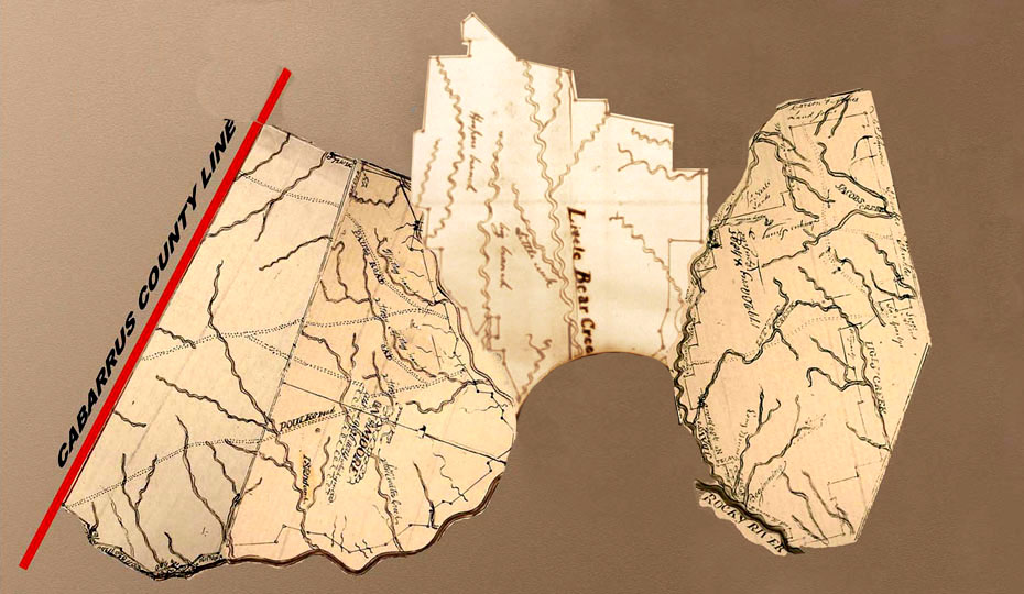
A block of seven of the twelve tracts of land was situated along the Rocky River in our region of south central North Carolina. These 100,00 acre pieces of land were quickly purchased by several men who in orchestration, controlled a major link in the migratory chain. George Stephenson who works at North Carolina State Archives showed me a map from whence the following was created. It identifies the location and initial ownership of these “great tracts” of land:
What eventually happened to all this land? Was it simply sold and resold until its appearance is as we know it today? Governor Arthur Dobbs died and at that point, did the remainder of his lands descend to heirs? Knowing of many land grants in this region later issued through the authority of the North Carolina Secretary of State, did portions of the tracts revert back to the state for issuance? Not yet knowing the details to answer these questions, a basic understanding of the “great tracts” is critical for the story that follows. Using a few records linking to notable people in our American history, I hope you too will be a bit more appreciative of the land and people from whence we came.
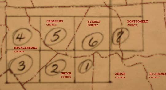 Tract 1: Owned by George Augustus Selwyn
Tract 2: Owned by Arthur Dobbs
Tract 3: Owned by George Augustus Selwyn
Tract 4: Owned by Henry Eustace McCulloh
Tract 5: Owned by Arthur Dobbs
Tract 6: Owned by James Huey
Tract 7: Owned by Henry McCulloh
The North Carolina Gold Mine Company
Just as Henry McCulloh purchased land on behalf of John, Baron Carteret; during the late 1700’s, speculators again purchased large tracts of land that they hoped to resale at a profit. But this was a different day and time. Remember that earlier, two of the great tracts were sold to Arthur Dobbs. Being the Governor of North Carolina, Dobbs gave a bit of political immunity to the men involved in that association. They were able to avoid the enormous tax debts that could arise from such speculation. After the American Revolution, tax collection was hit or miss based on the county and the will of the acting sheriff. While some speculators were able to buy and hold on to land for later resale, others lost everything.
Cabarrus County was formed in 1792 and adjoined then Montgomery County to the east. That portion of Montgomery County became Stanly County in 1842. The courthouse in Montgomery County burned destroying nearly all the county level records. As located in Secretary of State Land Grant records, Thomas Carson, William Moore, and Barnaba Dunn were jointly issued four grants containing over 50,000 acres in what is now Stanly County. Though the survey for one of the issuances does not survive, the remaining three provides a wealth of information. They identify other owners of previously acquired land within and adjoining the bounds of the tracts. Waterways, springs, and roads are also identified. One of the tracts represents a mile wide strip adjoining the Cabarrus County line. Another tract adjoins this tract containing a large amount of land in the southern tier of present day Stanly County. And the last tract adjoins this to the east. The plats and legal information pertaining to the four tracts appears below:
Grant (No. 770, Montgomery County NC) 3,200 acres.
Entered 28Aug 1794, Issued 11 May 1795
Issued to Thomas Carson and William Moore
NO PLAT AVAILABLE____________

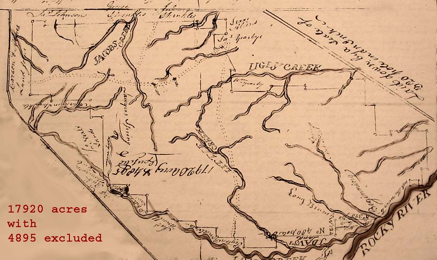
Grant (No. 772, Montgomery County NC) 17,820 – 17880 acres.
Entered 2 Nov 1794, Surveyed 16 Dec 1794, Issued 11 May 1795
Issued to Thomas Carson and William Moore
By virtue of 27 warrants of 640 acres each with one being 600 acres, land lying in the Forks of Rocky River and Long Creek and Bear Creek.
Excluding lands within the survey owned by the following: Thomas Larron 150 acres, Bozman Adare 150, John Smith 150, James Exum 200, Bryan Whitfield 150, Exodus Whitley 250, George Cagle 425, David Cagle 150, Lewis Whitfield 100, John Morrison 150, Edmond Lilly 200, Simms Metheney 100, Jesse Gilbert 150, Christopher Cagle 100, John Cress 300, Alexander Pool 106, Saunders Pool 100, William Phillips 50, William Brooks 400, John Brooks 150, Samuel Fratwell 100, Spencer Self 120, William Witherspoon 101, John Hartsell 100, John Blackwilder 100, Valentine Cagle 150, Charles Cagle100, James Bankston 200, and John Christian 4375
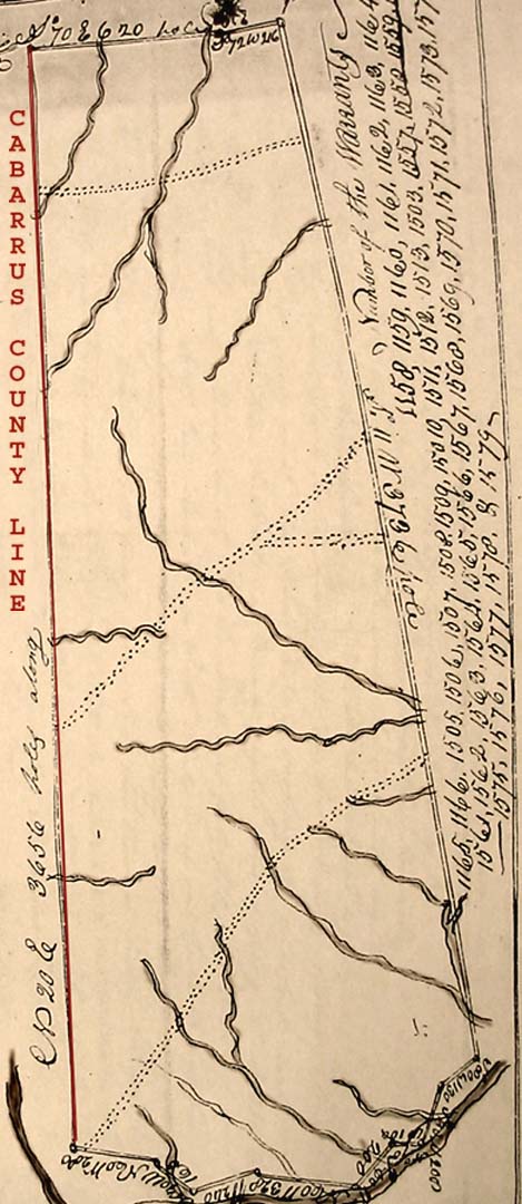
Grant (No. 773, Montgomery County NC) 17,920 acres.
Entered 28 Aug 1794, Surveyed 29 Nov 1794, Issued 11 May 1795
Issued to Thomas Carson and William Moore
By virtue of 28 warrants of 640 acres each lying on the southwest side of the Pee Dee River and on the North Side of Rocky River.
Excluding lands within the survey owned by the following: ______________, Phillip Lench 100, Jincy Robinson 400, William Lee 150, Hnery Taylor 200, James Fletcher 400, ____ Whitfield 740, Josiah Vickory 200, Robert Stelle 640, John Brooks 100, George McSwan 200, Joshua Hadly 300, Edward Almond 100, Jonas Yeomans 160, Peter Hamlett 100, William Crittendon 25, John Brooks 100, William Kindle 100, George Shankle150, Jacob Shankle 200, and John Christian 400.
Grant (No. 775, Montgomery County NC) 26,880 acres.
Entered 28 Aug 1794, Surveyed 5 May 1795, Issued 11 Mar 1795
Issued to Barnaba Dunn, Thomas Carson and William Moore
By virtue of 42 warrants of 640 acres each lying on the southwest side of the Pee Dee River and on the North Side of Rocky River adjoining the Cabarrus County Line and Bear Creek, Rock Hole Creek, and Camp Branch.
Unlike other speculators, Carson, Moore and Dunn hit the jack-pot. Shortly after they purchased the land in Montgomery County, young Conrad Reed discovered gold nearby along the border in Cabarrus County. These men jointly owned a very large tract of land adjacent to the first gold discovery in America! Heard world wide, news of the discovery of gold reached Dr. William Thornton in Washington City, District of Columbia. William Thornton is well known in his own right as designer of the United State Capitol Building. He also developed the layout for the City of Washington, D. C. Before his death in 1828, William Thornton was appointed to head up a new agency known today as the United States Patent Office. And it is he who heard of gold and reacted by purchasing the lands above.

This indenture made this 18th day of May in the year if our Lord 1811 between John K. Carson of Cabarrus County and the State of North Carolina of the one part and William Thornton of Washington City of the other part. Witnesseth that … the proprietors [Carson, Moore, Dunn] afterwards conveyed their interest in the said four tracts [in excess of 35,00 acres] to the said Thomas Carson who sold quantities of the land to several persons and died leaving the said John K. Carson such of the lands as had not before sold or conveyed on or about the 5th day of December 1805.John K. Carson wit:
Israel Pickens
James Pickens
Also included in the Supreme Court case is Exhibit “B” being the last will and testament of William Thornton. Written 13 Mar 1828, he mentions wife Anna Marie and her mother Ann Brandau. Being the first item in the will, William Thornton states:
First, I direct that all my Just debts be liquidated and paid and those also for which I am justly answerable which I possess will be effected by the sale of such parts of my stocks in the Gold Mine Company of the State of North Carolina at present unsold as shall leave five hundred and fifty shears – unsold - for purposes hereafter to be mentioned The stock of the Gold mine Company consists of Eleven Hundred Shears and were valued at one hundred dollars a shear Where the purchase made for the company consisted of thirty five thousand acres of land whereas by an addition of eighteen thousand acres it now consists or contains fifty three thousand acres and by a late survey it is calculated to contain more than sixty eight thousand acres. The shears are Therefore supposed now ___________ of the Interest of the Money in each – Two Hundred and eight dollars a shear.William Thornton continues by mentioning his land and marine shop in Montgomery County, Maryland. He also identifies other lands including that on the Island of Tortolla.
Recorded in Superior Court of Stanly County NC, the following deposition is found among the loose ejectment papers leading up to the eventual 1855 Supreme Court case of Daniel Freeman vs. Hastings Hatley:

District of Columbia
County of Washington
19 Mar 1852 The witness, Anne Maria Thornton, after being duly sworn according to Law deposeth and saith as follows.I know none of the parties this case. I am the widow of Doctor William Thornton of Washington City. I know of a certain large tract of land in Montgomery County now Stanly County North Carolina and in going to it I crossed the Yadkin River, I know that the above tract of land was purchased by William Thornton my late husband from John K. Carsons I know the above lands from the fact of having been upon them at different times & having rode over different portions of them – I was there in 1805 and 1806, and once since not recollected. I believe the conveyances was from John K. Carson as Executor of Thomas Carsons a portion of the lands I speak of lay near what is called Reids Gold Mine, and I always understood that Cabarrus County was one of the boundaries of the tract of land and that Rocky River was another boundary of the above land. I always understood that Long Creek & Bear Creek were on portions of this tract of land. My Husband William Thornton purchased the lands I think in the year 1805 and continued to own them up to the date of his death. He died in the year 1828. I always believed that the deed from John K. Carsons was sent to John Culpepper to be recorded in Montgomery County North Carolina and that the money to pay for the recording the said deed was sent with it and that the said deed was never returned to my knowledge and I have always understood that the said deed was burned in he Court house in Montgomery County North Carolina, these lands were conveyed by John K. Carsons to William Thornton by a deed in fee simple. I do not know exactly the number of acres of land in the above tract but since the death of my husband, up through the time I sold the lands through my agent John __________ Sub Attorney under power of attorney from me to the Hon. Edmund Deberry I paid taxes on the above 53000 to 65000 acres. Since the death of my husband I at one time employed George C. Bumford to survey & examine the said lands & he visited the same. He had authority from me to lease any part of them as he had an opportunity. My Mother Ann Brodeau, who’s spoken of in my late husband’s will died the 4th day of July 1836. I have not nor never had any children. I had power in my husband’s will to depose of all my husband’s Estate.
Anna M. Thornton
Beginning with the purchases of “great tracts” in south central North Carolina, speculators throughout the region continued to invest in what they thought to be a means of advancing personal wealth. The men Carson, Moore, and Dunn purchased a sizable portion of the remnants of tract No. 5. Gold was found and they in turn sold the land to William Thornton. I am not at sure of how successful William was in his mining operation. There is evidence of mines spread throughout the land in question. From present day Locust to Rock Hole Creek situated south of Stanfield, old mine shafts and cuts in the terrain hearken back to these early days. And though much of the story is lost in the form of a courthouse fire, other stories can also be told through the study of higher court records.
A look at Tract # 2
as defined in the Supreme Court Case Dock F. Mann vs. William H. Taylor
Appealed from the 1856 term of the Stanly County Superior Court, a suit between Dock F. Mann and Daniel Freeman is built upon records that predate the formation of Stanly County. Daniel Freeman somehow acquired land from Dock F. Mann of which he later sold 174 acres to William H. Taylor. The land is described as adjoining George Reed lands. Seeking to recover his land, Dock F. Mann instituted an action of ejectment against Daniel Freeman. Copies of the declaration were also served against present owners of the land, Lloyd Taylor and William H. Taylor. Appearing as evidence in the case, copies of two early land records give us a glimpse into the records that predate the formation of Stanly County. First, a deed dated 13 Aug 1833 records a transaction between Stephen Kirk and Thomas J. Shinn. A portion of the deed is as follows:
This indenture made the 13th day of August A.D. 1833 Between Stephen Kirk of the County of Montgomery and the State of North Carolina, of the one part, & Thomas J. Shinn of the County & State aforesaid of the other part, witneseth that for and in consideration of the sum of one hundred & fifty dollars… hath bargained and sold unto the said Thomas J. Shinn a certain parcel of land situated lying & being in said county on the waters of Reedy Branch. Containing one thousand nine hundred and ninety nine acres, and with the exception of two hundred acres deeded to Tucker & Shinn, the land adjoins that owned by Tucker, Shinn and Smith.S. Kirk Little C. Shinn
P. Kirk
The second piece of evidence appears as the following copy of the land grant from King George II to Arthur Dobbs:
On their own merit, these two documents add to our understanding of the region predating the formation of Stanly County. But found in the concluding statement of the lower court, the following expands on the above:
George The Second by the grace of God of Great Brittain, France & Ireland – King defender of the faith & c. To all to whom these presents shall come greetings whereas we having by our order Council directed our Surveyor General of our province of North Carolina or his deputies to survey & lay out twelve hundred thousand acres of land, upon the head of the Pee Dee, Cape Fear, Neuse Rivers, as by relocation being thereunto had may more fully appear to Murry Crymble, James Huey & such other persons as are associated with them, entitling the said Murry Crymble & James Huey & their associates to take out separate grants for the said lands in such portion as shall be required by them provided that no grant contain less than twelve thousand acres, no know ye, that we agreeably to the power, & in pursuances of, the several privileges of granted by the said recupted order in council and also for and in consideration of rents & duties herein reserved, do give & grant unto Arthur Dobbs From Castle Dobbs ( in Ireland) Esquire, one of the associates of the said Murry Crymble and James Huey, a tract of land containing twelve thousand five hundred acres subdivided from tract No. 2 surveyed by Mathew Rowan Esquire upon the branches of Great Pee Dee and Johnston River [now known as Rocky River] Beginning at a stake running thence north 500 chains thence west 250 chains thence south 500 chains thence east 250 chains to the first station and blundered by the tract “R” to the south and east “Y” to the west to have and hold the said lands with all rights and privileges of hunting, hawking, fishing, & fowling, with all woods, waters, and Rivers, with all profit, commodities and henderments tp the same belonging or appertaining to him the said Arthur Dobbs his heirs & assigns for ever in full manner of East Green which except that in case any mines should be found on the Said lands, one fifth part of all gold & silver ore and one tenth part of the ore of all other mines and minerals whatsoever, be reserved for the use of us, our heirs, and successors yielding and paying unto us, our heirs, & successors, yearly after the expiration of ten years from the date of these presents, four shillings proclamation money for every hundred contained in said tract and provided also that the said Arthur Dobbs, his heirs, & assigns, do settle unto the term of ten years upon the lands so granted, according to the proportion of one white person for every two hundred acres contained in this grant otherwise such proportion of the lands as are not so settled shall revert to us our heirs & successors but at the same time it is provided that no advantage shall be taken of such lands, if any should happen until such time as we shall think to resume the said lands as forfeited for want of being so - settled within the term of ten years the grantee, his heirs or assigns being still liable to pay suit, rent of four shillings proclamation money for every hundred acres contained in this grant until our pleasure thereupon is further known. In testimony whereof we have caused the seal of our said province to be hereunto affixed, witness well beloved Gabriel Johnston Esquire, our Captain General Governor & Commander in Chief in & over our said province at Edenhouse the 3rd day of March “Anna Domini” 1745. By his Excellency’s command, James Craven, Sept. Secr’y.
The plaintiff offered in Evidence the copy of a Grant for Arthur Dobbs bearing date the 3rd of March 1745 a copy of which forms a part of this case for twelve thousand & five hundred acres of land. And then a Deed from Parham Kirk Sheriff of Montgomery County to Stephen Kirk for 1999 acres of land sold for taxes, also a deed from Stephen Kirk to Thomas J, Shinn, bearing date the 13th of August 1833 for 1999 except 200 before conveyed. A copy of which Deed also forms a part of this case. The plaintiff then introduced a deed from Shinn to one Reed and a transcript of the proceedings of Cabarrus Court of Equity where certain land was sold by decree & which was alleged by plaintiff to be the land in controversy & which was purchased by one Hartsell who conveyed to Doctor F. Mann the lessor of the plaintiffs.
For the purpose of locating the Dobbs grant the plaintiff introduced one David Kizer who swore that about 40 years since he was present at the trial of a suit in Cabarrus & there heard one Love who was sworn & who is since dead & who testified on said trial in Cabarrus that thee was a post oak tree marked as a corner at the gum Pond, & that post oak was said to be the corner of tract Number two of the big survey. William Stancel, a surveyor, testified that he had surveyed the land in controversy and began as directed, finding no corner there or pointers, and run east on old marked line towards the Gum Pond that the line looked old though he did not box any trees. - and said marked line did not continue, the length of the line he was surveying for plaintiffs, but only a part of the way – and he found no corner at the Gum Pond to which he run, nor any pointers – and he then run south a short distance from the Gum Pond according to the calls of the plaintiffs courses finding no other marked trees except a few of recent date – and further stated that if these were true lines the plaintiff deed would cover the land in dispute.
The plaintiff introduced Thomas J. Shinn to show a seven years possession, who testified, that there had been a house built on the land several years & occupied by different persons for more than seven years from the first occupancy up to the time of commencing this action, but could not say the possession hand been regular and continuous, though it might have been.
His Honor charged the jury that of they believed the evidence of Daniel Kizer & William Stancel that the Dobbs grant was located – and the grant placed the title out of the state, so that the a seven years continued possession by the plaintiff to recover - & the jury were to say from the continued possession for seven years, The Counsel for the defendant moved the court to charge the jury that the Dobbs grant was void for uncertainty, & could not be located, which was declined – The jury found a verdict for the plaintiffs. Rule for a new trial.
1st Upon the ground that the Dobbs grant was void upon its face for uncertainty & could not be located any where.
2nd That the evidence was not sufficient to locate Dobbs Tract.
3rd That the proof as to the seven year possession by the plaintiff & those under whom he claimed was not sufficient & judgment for the plaintiff – The defendant prayed an appeal to the Supreme Court which is granted – appeal bond filed.
6101 Ballou Court
Raleigh, North Carolina
27609
Copyright © 2003 by George G. Thomas