


undefined
After owning my GPS for a couple of years and learning how to figure out coordinates for places I had not been before, I decided to put the GPS, my method of figuring coordinates and my ability to use a map and compass, to the test. I was determined to find out if I could depend on my GPS to take me to a designated place I had never been and knew nothing about, except for what I could see on the map. In order to do that, I knew I had to go somewhere I had not gone before. The place that I chose for that purpose was the Clifty Wilderness.
In the late summer of ’96, Mike, a friend of mine, and myself planned a hike into the Clifty Wilderness. I sat down and studied the map, figured out all the coordinates for the significant places along the way, such as where we would be leaving the trail, re-entering other trails and of course, our final destination. Our destination was an old cemetery that was marked on the map, at a place called Calaboose Ridge.
Our plan was to park in the Wildcat Trail, trailhead parking lot, on Rt. 715 and enter the Wildcat Trail from there. We would follow the Wildcat Trail until it intersected with Swift Camp Creek Trail, turn left and follow this trail to coordinate N37°47.567’ x W83°34.083’. At this point we were to exit Swift Camp Creek Trail, to the right, go down a steep embankment and cross Swift Camp Creek. From here we would enter the cut, or hollow, that was pretty much straight in front of us. We would follow this cut, upward, to coordinate N37°47.717’ x W83°33.650’. At this point, we would come up out of the cut. From here, we weren’t sure what we would find. On the map, there was a trail showing, not too far from where we would exit the cut. However, considering that the data for these USGS maps was gathered almost fifty years ago, we knew that this trail may no longer exist. One thing to note here, is that once you leave Swift Camp Creek Trail, there are no maintained hiking trails in the direction we were going.
We got started on our hike somewhat later than we had intended, because we had stopped to help two ladies that were having car trouble on Mountain Parkway. By the time we got the smouldering fan belt removed from the car and escorted them back to Stanton, we had lost quite a bit of time. Therefore, when we actually started walking from the parking lot it was around 11:00 AM. The predicted high for that day was 92 degrees.
Since we were planning going off trail, we had to carry emergency supplies, in case we got lost or had some other problems. With the gallon of Gatorade each of us were carrying, we each ended up with a pack that weighed about 25 pounds.
Walking the Wildcat Trail and The Swift Camp Creek Trail, was pretty much uneventful in terms of hardship. These trails aren’t very difficult and the hardest thing we encountered was a couple of large trees that had fallen across the trail. With a little scrambling, we got across those with no problem.
Shortly after we entered the Swift Camp Creek Trail, we started watching our GPS to make sure we didn’t go past our designated spot. When we were nearing the place we were supposed to leave the trail, we entered into an area covered with heavy foliage. At that point we lost our satelite connection. By the time we got our satelite connection back, the GPS was showing that we were past the point we were looking for. So, we started walking slowly back, watching the GPS closely. Finally after studying the GPS carefully, we decided we had found the place we were looking for. As it turned out, we had found the right place to exit the trail, but it was pretty steep. My guess is that it was probably a 50 foot embankment and almost straight down. However, by hanging on to small trees and limbs, we were able to make it down without breaking anything. This brought us down into Swift Camp Creek.
By the creek and at the bottom of the embankment there is a large boulder. It’s probably as big as an average sized room, in most houses. Still, if there’s a lot of leaves on the trees, you would have trouble seeing this boulder from the Swift Camp Creek Trail. Once you start down the embankment, of course, you can see the boulder much more easily.
At this particular point, at that particular time, Swift Camp Creek was shallow. Luckily we were able to wade across it, stepping on stones, without getting water over our boots.
After crossing Swift Camp Creek and taking a short break, we headed on into the woods, looking for the cut. Even though the going was not easy, because of the heavy undergrowth, we found the cut and the GPS told us, it was the right one. We continued on up the cut, staying on the right side and up the hill from the bottom, a little bit. The going through here was unbelievably rough due to the heavy growth of Laurel. The only thing I can think of to compare the Laurel to, is a thicket of grape vines. Much of the time we were actually crawling and considering the fact that we were carrying packs, it was not easy to get through that stuff. Even though it was a rough go, we finally did make it up out of the cut and into a pretty heavy stand of small pines. If you count the contour lines, you can see that there is about a 400 feet gain in elevation, from the creek, up to the high point, at the top of the cut.
At this point, we were pretty much relying on the map and compass to keep track of where we were because the heavy foliage overhead was keeping the satelite signals from getting to the GPS. In order to get a reading from the GPS we had to find a thin spot in the foliage and stay there long enough for the GPS to pick up the signals. I think it’s safe to say, however, anywhere you get sunlight through the foliage you can usually pick up the satelite signals.
After another short break, we proceeded on through the pine thicket, hanging trail tape as we went. The first thing we did was check to see if we could find the trail that was showing on the map. Luckily we did find just a trace of this old road or trail, most of which was no more than a small indentation in the bed of leaves. We followed this old trail and then, much to our surprise, it ran into a well worn trail. This trail turned out to be Calaboose Ridge and it looked like it had been used as an ATV trail.
Needless to say, we were relieved that we wouldn’t have to fight our way through any more Laurel, to get to our destination. The rest of the hike to our destination was just a matter of hiking there. There was no serious obstacles in our way.
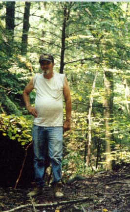
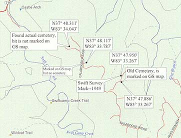
When we were getting near the spot where we thought the cemetery was supposed to be, we started watching the GPS again. The coordinates for the cemetery marking were N37°48.117’ x W83°33.787’. When the arrival alarm went off, we started looking around for a cemetery. However, we could see no signs of a cemetery, whatsoever. We looked and we compared the terrain to the topography of the map and we were convinced that we were in the right spot, but there was no sign of a cemetery. At this spot is where the "Auto Camera Shot" picture was taken. I put the camera on an old rotten stump, set it on "Auto" and ran back to stand beside Mike, for the picture.
By this time it was 4:00 PM. It had taken us 5 hours hiking to reach this point, with not much more than a few 5 minute breaks, except the time we took to explore the destination point. Even though we hated to leave without actually finding the cemetery, we knew if we were going to get back to the parking lot before dark, we had to get started back.
Our trip back was much quicker, due to the fact that we had hung trail tape. We picked up our trail tape as we traveled back and even though we had hung trail tape heavily, through the Laurel, it was still hard to find some of it. Let that be a warning, if you ever travel through heavy Laurel (God Forbid) be sure to hang plenty of trail tape. It will make your return trip much quicker.
By the time we got back to Swift Camp Creek, we were pretty worn out. We stopped for a few minutes to wash our faces and cool off, because we knew we had to scramble back up that steep embankment and as tired as we were, we knew that was not going to be easy.
However, we did manage to make it back up the embankment and back onto Swift Camp Creek Trail. After that, again, it was just a matter of hiking back to the parking lot. When we finally got back to the parking lot, we had drank virtually all our Gatorade and it was 7:30 PM. It had taken us 8 ½ hours to go round trip to where the cemetery was supposed to be.
After returning home without finding the cemetery that was marked on the map, I became more determined to find out what was going on. I got the map and started looking for an easier way to get to that area. I was already convinced that the GPS had done it’s job and had taken us to the right spot, but I just wasn’t content with letting it go at that. I wanted to find that cemetery.
As it turned out, there was a much easier way to get back into the area where the cemetery was supposed to be. According to the map, there was a couple of unimproved roads that would take me fairly close to the spot where we had hiked out onto the Calaboose Ridge trail. Therefore, my next trip to that area was in my 4-Wheel Drive S-10 truck, accompanied by my wife, Barbara. We followed the asphalt road until it ran out and then we were on a dirt/mud road. We followed the dirt road for a few miles, with my wife driving and me watching the GPS to make sure we were heading in the right direction. Finally we came to an area where 3 dirt roads or trails all came together. This is as far as I felt like we should go in the truck so we stopped and turned around. I got out of the truck and took some readings from the GPS and my compass and determined that we were less than a mile from the place where we had intersected Calaboose Ridge, on our hike. This was good news. As a matter of fact, I was downright excited.
As I was driving back toward Campton, I was trying to figure out some way to find out more about the area that I had just visited. As I came to the first house that I’d seen since leaving the wilderness area, I stopped and knocked on the door, figuring that since they lived so close to the area they might know something about the cemetery in question. I was greeted by a nice young lady that turned out to be the daughter of the lady living in this house. Then, the lady of the house came to the door and I explained, to her, what I was doing in the area and asked if she could help me. Even though they were very nice people and wanted to help, they could tell me nothing about the cemetery on Calaboose Ridge.
As I got back in my truck and headed on toward town, I was watching for someone that I might be able to approach and ask about the area in question. Just a few miles down the road, I spotted an ATV sitting parked in a yard. I knew this presented some good possibilities. With an ATV, I knew anyone could get really close to where I was wanting to go. So, needless to say, I stopped. As I pulled into the driveway, a guy came out on the porch. This turned out to be a guy named Chuck. We said our "Howdies" and I explained to him what I was trying to figure out. At first he was skeptical of me. He told me later, that he thought I might be one of the people still looking for the lost, Swift Silver Mines. I had to admit, I couldn’t blame him. After all, how many people go to this much trouble trying to find a cemetery that they know nothing about? After we talked a little while, I showed him my maps and he took a look at my GPS and as it turned out, he was interested in learning more about navigation and the GPS. So now we were on a little more common ground. Chuck gave me quite a bit of information about the area and some of it’s history, but he knew nothing about the cemetery that was marked on the map. So, as I was leaving, Chuck invited me to stop by if I ever came that way again and I headed on back toward Ohio and home.
However, this wasn’t over yet. When I got back home I immediately started making plans for another trip into the Clifty Wilderness. Later that month, another friend of mine, named Tom, decided to go back into that area with me. We drove the truck as far as we could and left it. Getting back to the supposed cemetery location was a piece of cake this time. There was no underbrush to worry about and no Laurel. It was all trail and that made for much easier going than we had had before, coming in from the other side.
When we reached the area in question, this time, we had more time than before to check everything out. With the map and compass, we took the necessary readings and sighted a line across where the cemetery was supposed to be. We also stepped off the distance that the cemetery was supposed to be from the trail and we still found nothing. We looked very closely for anything that might have even looked like a field stone that might have been used for a grave marker and there was no sign at all. We walked around the whole area and compared the terrain to the map and there was no doubt. The map and the GPS agreed, we were in the right location and there was no cemetery.
As we were driving back out of the area, I stopped to see Chuck again. I told him about not being able to find the cemetery and also, about us being convinced that there was no cemetery there. This aroused Chuck’s curiosity and interest. He told us that he would start asking around the area and see if he could come up with any information for us. So, I left Chuck’s place and came on back home, still wondering what was going on with the map and the cemetery.
A few days after I got back home, I decided to call the U.S. Geological Survey National Mapping Division. The guy that I talked to there was a Mr. Donald E. King . I explained to him, what I had been doing and asked him if he thought there could have been a mistake made, on the map. He took the information about the location of the cemetery, as it was marked on the map, and promised he would get back with me after he had gathered more information.
A few weeks later, Mr. King did get back with me. He sent me some copies of older maps and he noted that on a 1951 scale 1:24,000 map, this cemetery was not marked on the map, even though it was marked on the newer maps. His conclusion was, that if there was a mistake, it was probably made by the person doing the field work. He also sent a lot of information about the map making process and all the accuracy requirements that are involved in the map making process. He was very helpful and cooperative about the whole thing.
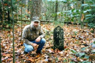
Meanwhile, Chuck had been busy asking around his area for information about the cemetery and he got lucky. As is often the case, the truth of the matter came from someone that had actually lived in a settlement, in that area, many years ago. These guys, Harold and Truland, knew nothing about any cemetery at the location shown on the map. However, they did take Chuck to another cemetery that was about two tenths of a mile as the crow flies, according to our GPS, from the spot that was marked on the map. The coordinates that the GPS gave us for that location are N37°48.311' x W83°34.042'. It was beside the Calaboose Ridge trail, on the same side and about the same distance from the trail that the other cemetery was supposed to be. There was only one head stone that had any writing on it, in this cemetery, and it was barely legible. According to the head stone, this grave was near 100 years old and it had been recently decorated with flowers. The rest of the graves were marked with field stones.
Now we know, Mr. King’s conclusion was pretty accurate. The topography of the map matched the terrain of the location perfectly, but somehow, somewhere, in the map making process, someone, probably the guy doing the field work, had put the mark in the wrong place. More than likely, no one ever paid any attention to the mistake until I needed a destination point to prove the abilities of my GPS... By the way, my name is Jim.
Click here for map of actual cemetery and empty location.
During this test hike, the GPS gave us the information necessary to find the locations that we were looking for. However, I don’t want to make this sound easier than it really is. When the "selective availability" is really bad, it is difficult to navigate with the GPS. (Selective availability was the intentional degradation of the civilian GPS signal, to varying degrees, by the defense department, to discourage unethical or terroristic use of the GPS system.) As of May 2, 2000, the Selective availability has been turned off, so your GPS unit will be much more accurate than before. For more details, click here. Now most GPS manufacturers have also added the new Wide Area Augmentation System (WAAS) to their units which has the potential to increase accuracy significantly. To read more about this feature, click here.
Anyone venturing off trail, in any wilderness area should also be proficient in the use of the map and compass. You no longer have the "selective availability," on the GPS to deal with, but there is still the possibility of being under heavy foliage, which may block the satelite signals. The newer GPS receivers have technology to improve their performance under these conditions, but it’s always better to be totally prepared.
Again, on our quest to see how useful the GPS can be, we set out to find the Swift-1949, permanent survey mark. These marks are called a Neace and they consist of a brass plate, about six inches in diameter, embedded in a concrete post that is about one foot square. These posts only protrude from the ground about 3 or 4 inches. These survey marks are designated on the USGS topographical maps by a small triangle.
This Neace is located near an old dirt road. However, the road has changed somewhat, due to past logging operations. This Neace, as well as the nearby cemetery, is also located on private property, close to the edge of the Clifty Wilderness.
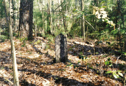
First, we tried to find the Neace by using only the GPS. Even though we gave it a good try, we found that the GPS just wasn’t accurate enough to find the one square foot of concrete, in the wooded area. However, there is another old cemetery marked on the map, about 500 feet or so, from the neace. I will note here, finding one of these old abandoned, unattended cemeteries is no easy task, either. This particular cemetery has nothing but field stones for headstones. This method of marking graves was, and in some areas of Kentucky, may still be customary. The first time I approached this cemetery, I walked within 10-15 feet of it and didn’t recognize it as the cemetery, at all.
The GPS took us to the cemetery and after looking around and moving some leaves, we did find the headstones. After we had found the cemetery we carefully took our readings from the map, with the compass, and sighted a line across the area where the Neace was supposed to be. After following this sighted line and again, moving some leaves and debris, we found the Neace.
The point I would like to get across, is, even though circumstances can make it rough sometimes, the GPS is still, by far, the best way to navigate. However, don’t leave your map and compass at home.
Click here for a zoomed out view of the covered area.
A good and easy book to read is "The Basic Essentials of MAP & COMPASS" (ISBN 0-934802-42-4) by Cliff Jacobson and illustrated by Cliff Moen. This book comes from ICS BOOKS, Inc. Merrillville, Indiana and is published by ICS BOOKS, Inc., 1370 E. 86th Place, Merrillville, Indiana 46410.

