
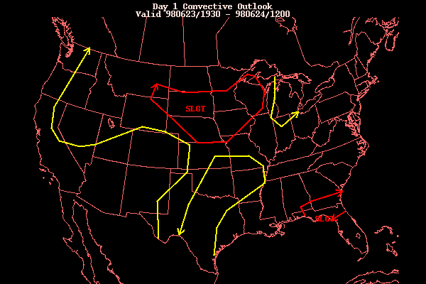
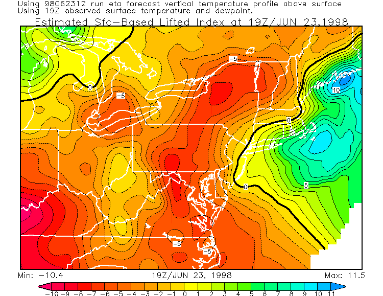
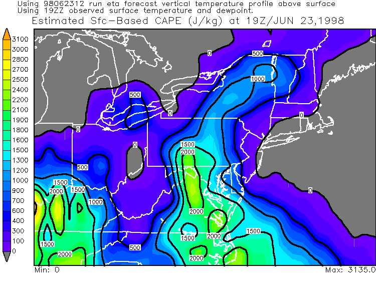
Flash Flooding/Severe Thunderstorms of June 23, 1998Unexpected severe thunderstorms erupted over central PA during the afternoon and evening. Thunderstorms were expected ahead of a cold front, with the possibility of flash flooding... however severe thunderstorms were not expected. SPC had none of PA or surrounding areas in a slight risk.... just the general risk. The graphic can be seen here. The NWS-CTP issued this statement in the late morning. This just goes to show how you can't rule out severe weather when most thunderstorms exist... especially when dew points are so high as they were today. Throughout the state, dew points were in the low to mid 70's! Other instability factors, such as LI's and CAPE, were enough to support severe thunderstorms, but not alone. If the dew points were not so high, the severe storms probably would not have fired up. Even with no other real good dynamics in place, thunderstorms can just spontaneously erupt very quickly in such moist air like today. Dew points don't get much higher than what we had this afternoon. The flash flood threat was rather good today because the mid and upper level atmospheric winds were very light... which means that there is not much to move the thunderstorms along. Some of the storms just sat over one place for an hour or more, dropping large amounts of rain in a short time. York and Tioga counties were probably the hardest hit, but many areas experienced flash flooding. On a section of route 116 near Hanover in York county, 3 feet of water covered the road! County emergency management agency workers needed to rescue many people. Rock and mudslides also occurred. Near the town of Tioga in Tioga county, people were evacuated, due to flash flooding of streams and creeks. Severe house and road flooding occurred in a few locations. In Luzerne and Wyoming counties, strong thunderstorms moving by caused some flooding and wind damage. In Beaumont, road flooding became significant... with water rushing down several streets. This caused deep grooves to be cut into the pavement, with some areas of asphalt washed completely away. Driveways were also torn up. In Port Blanchard, a wooden fence was destroyed from the rapidly moving flash flood waters. Countless basements had water in them. Front and backyards had many inches of water covering them... making a virtual lake. In Wilkes-Barre, city streets had over a foot of water on them in spots. Some people tried to make it across the flooded roads... and crossed with no problem where there was a few inches of water. But where there was one foot or more... several vehicles were trapped. Although the biggest problem with this area of thunderstorms was rain, isolated strong wind gusts were also generated. A tree was downed onto a house in Kingston, taking a large piece of sidewalk with it. In Plains, a large tree was toppled in a residential backyard... smashing a wooden fence and damaging a pool. Like I said before, the severe thunderstorms were not expected, but they can really never be ruled out in an airmass like today's. The first svr tstm warning was issued for Elk county, as was the first flash flood warning. Pea size hail fell in Ridgway, and trees were downed in a few different area in the county, especially in the Boot Jack area. Small streams flooded roads and fields in the western part of the county. Both severe thunderstorm and flash flood warnings were issued for numerous counties in Pennsylvania. Two tornado warnings were also issued, one for Bedford county, and the other for southern Fulton county. Funnel clouds were observed but no touchdowns were reported. Trees were downed in most of the counties warned, some on houses. Up to nickel size hail fell in select locations. Port Allegany (McKean county) reported both nickel size hail and trees downed as a severe thunderstorm crossed that area. Many areas in Potter county had flash flooding due to torrential downpours. There was a report of over three inches (3.15") of rain in 40 minutes near the town of Genesee!! Normally, this would be hard to believe... but due to the nature of the flooding problems it would seem to be an accurate measurement. Very rapid flooding of streets, fields, and basements occurred as small streams and creeks poured over their banks in minutes. In Bedford, Franklin, Dauphin, and Lebanon counties (all of which had flash flood warnings issued), many road were closed. Cars were stalled in numerous locations... especially in flooded city streets.
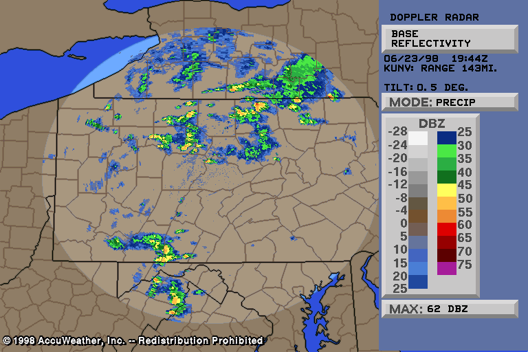
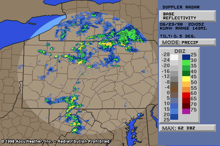
Click on one of the NEXRAD Doppler radar images below to see the actual image.
Click one below to read text from the NWS.
Flash flood warnings and statements Go here for a complete listing of all images/text available for this event.Email: BowEchoCPA@suscom.net |
