
MALAPERT MOUNTAIN REVISITED
Burton L. Sharpe[1]
and David G. Schrunk[2]
ABSTRACT
This paper describes a place - "Malapert Mountain" - in the South
Polar region of the Moon whose physical features and location make it highly
promising as a strategic site for the next stage of lunar exploration. The paper is an update of the authors'
previous paper on the same subject, and significantly refines, corrects, and
expands pertinent prior data.
INTRODUCTION
A prominent mountain ("Malapert Mountain") in the south polar region
of the Moon has features that are very attractive for the next stage of lunar
exploration and lunar base development. The present paper reports the results
of reinterpreted radar-based topographical data. It is concluded that the mountain has high strategic value as a
site from which to begin and to coordinate the exploration of the south polar
region of the Moon.
MALAPERT
MOUNTAIN Malapert Mountain is located at 0° Longitude, 86° South Latitude in the south polar region of
the Moon (Figures 1 and 2). It was previously reported (9) that the summit of
the mountain has an altitude of 8000 meters (3). Although the distance from portions of the base of the mountain
to the summit are approximately 8000 meters, interpretations of Earth-based
radar imaging data indicate that the summit of the mountain projects
approximately 5000 meters above the reference surface ellipsoid of the Moon
(4). The difference in these elevations is explained by the fact that imaged
portions of the base of the mountain are below the reference surface ellipsoid
of the Moon. The location of the mountain and elevation of the summit are
attractive for the next stage of lunar exploration for four reasons: 1)
Abundance of sunlight, 2) Earth visibility, 3) Access to scientific points of
interest, and 4) Logistical and operational advantages for lunar science and
engineering projects.

Figure 1. Combined Clementine mosaic and Earth-based
radar image of the south polar region of the Moon. The
subject mountain is located at 0° Longitude and 86° South Latitude is highlighted (NASA).
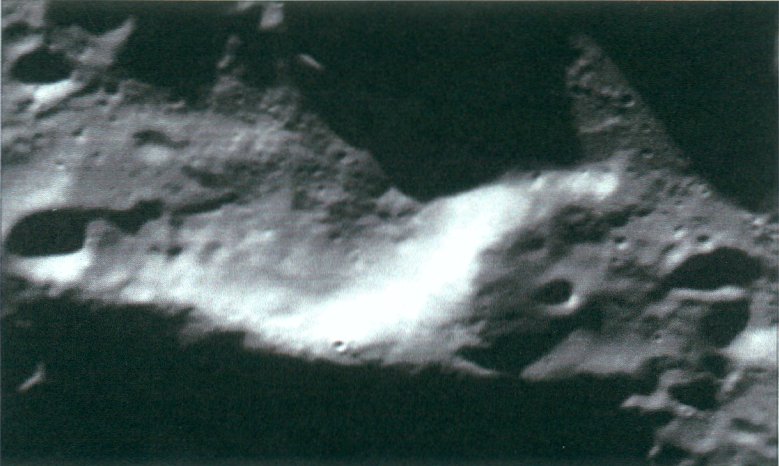
Figure 2.
Blow-up image of the subject mountain in Figure 1 (NASA).
Abundant Sunlight Access to sunlight is critical for lunar activities because
sunlight is needed for the generation of electric power (with solar panels) and
for other energy management systems. By
virtue of its location near the South Pole and its 5000-meter elevation, the
summit of the mountain receives less than full sunlight for only 11% of the
time, which is far greater than non-polar regions that receive less than full
sunlight 50 % of the time. The long duration of sunlight at Malapert Mountain
thus makes it a very attractive site for lunar base activities. Table 1 lists the projected sunset / sunrise
events over the course of the lunar year at the summit of Malapert
Mountain.
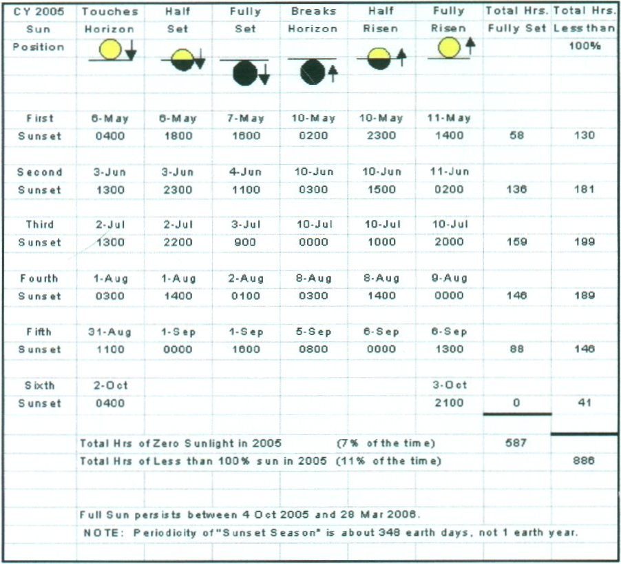
Table 1.
Schedule of sunset / sunrise events at Malapert Mountain The table projects the
number of hours that the sun passes below the horizon during the year 2005 at
lunar 00 Longitude, 860 South Latitude, and 5000 meter
elevation. Every year is different, but
most years have about 6 sunsets of similar duration, followed by 5-6 months of
full sun. For 2005, the summit of
Malapert Mountain is projected to receive full or partial sunlight for 93% of
the time.
Earth Visibility The second advantage is
that the summit of Malapert Mountain is always in direct line of sight with the
Earth for uninterrupted real-time control of robotic devices (a virtual
presence for Earth-based operators) on the lunar surface. Figure 3 illustrates
the locus of Earth's libration motions as seen from the summit over a one-year
period (5); the entire disk of the Earth is always above the horizon, allowing
for direct Earth-Moon communications 24 hours per day every day.
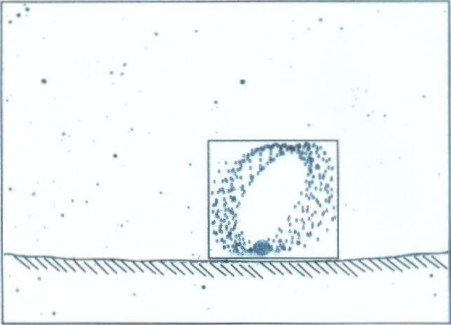
Figure 3. Locus of Earth's libration motion for the
year 2005. For any given location on the Moon, the
Earth's libration pattern with respect to the Moon is fixed. From a location at the mountain's summit,
the bottom of the libration box is approx. ½ degree above lunar horizon. The field of view for this figure is about
60o by 40o and for the libration box is about 12o
by 14o. The always-visible Earth above the lunar horizon means that
continuous real-time communications between the Earth and the Moon are
possible.
Other high elevations in the south polar region also
have the Earth in view continuously and receive long periods of sunlight, and
they may be considered as sites for lunar bases. For example, two potential base sites at 84.50 South
Latitude, 390 East Longitude and 83.50 South Latitude, 380
West Longitude have the Earth in view continuously and receive less than full
sunlight for 15% and 24% of the year, respectively, as shown in Table 2.
However, the combination of Earth visibility and long duration of sunlight
strongly favors Malapert Mountain over other candidate locations as the first
site for the next stage of lunar exploration.
Table
2. Sunset events of other potential
lunar base sites located at 84.50 South Latitude, 390
East Longitude and 83.50 South Latitude, 380 West
Longitude.
Science Opportunities Malapert Mountain may be
considered as a prime candidate for the establishment of the first scientific
base on the Moon. Long periods of
sunlight and a continuous communication link with the Earth, as exist at
Malapert Mountain, are highly advantageous for conducting scientific and
exploratory missions (2, 8). (A mission to Malapert Mountain would also provide
information about the precise altitude of the mountain and the profile of the
horizon as seen from the summit). Interpretations of data indicate that the rim
of Shackleton Crater, which is located at the geographic South Pole, is visible
from the summit at a distance of 122-Km (76-Mi.). Thus, the mountain could become the center of communications and
power generation (and power beaming / energy management) for exploratory
missions to the South Pole and surrounding regions.
Malapert Mountain is
located near areas that may contain water ice, as suggested by the Clementine
and Lunar Prospector Satellite Missions (1). If the presence of water ice is
confirmed, lunar base development will be greatly facilitated because water and
its hydrogen and oxygen components will be needed for a host of lunar industrial
/ scientific processes and for biological systems. The areas at the base of the
mountain are well suited for the operation of telescopes, particularly radio
telescopes that can be shielded from the radio noise of the Earth and infrared
telescopes that are placed on the low-temperature floors of permanently
shadowed craters. The difference between the sunlit and shadowed areas of the
mountain will permit experiments with circumferential utilities (just below the
summit) (6), and long periods of sunlight can be applied to in-situ resource
utilization experiments (7).
Logistics Advantages The fourth advantage is
that the topography of the mountain renders it suitable for initial and
follow-on missions. Existing navigation technology will enable automated supply
missions to target, maneuver, and land at the mountain's summit, where, by
inspection, there appears to be roughly ten square kilometers of area that is
suitable for logistical operations. Also, the slope of the mountain to the
northwest is less than 100, which would allow wheeled vehicles to
egress the mountain on treks to other areas in the south polar region, and
return (see Figure 4). The summit is also the logical point (the high ground)
from which to coordinate and support the growth of bases throughout the south
polar region.
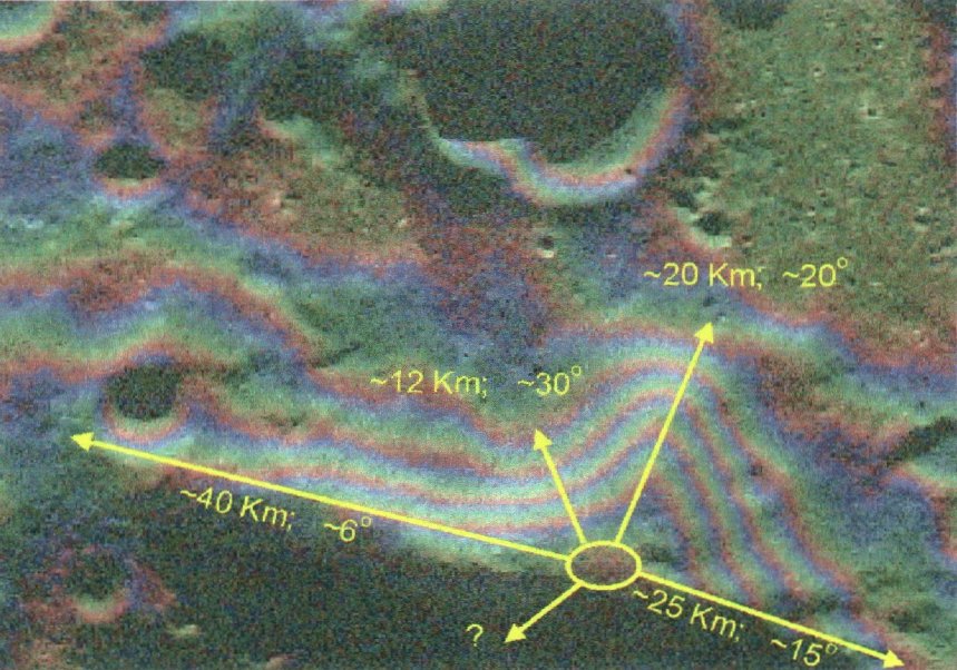
Figure 4. Downslopes away from the summit. The slope to the West-North-West from the summit is less than 100,
which can be easily traversed with existing robotic systems.
SUMMARY
Malapert mountain has unique and operationally optimum features that are
advantageous for the next stage of lunar exploration. A direct, high bandwidth
communication link with the Earth for continuous, real-time control of devices
is possible from its summit, and long periods of sunlight are available for the
operation of energy systems. The
mountain is suitable as a strategic base from which to conduct scientific and
exploratory missions throughout the entire south polar region. From the standpoint
of mission planning, the Malapert Mountain offers unique opportunities for the
future exploration and development of the Moon.
REFERENCES
1.
Binder,
A.B., "Lunar Prospector: Overview". Science Magazine, VOL 281, 4, pp 1475-76,
September, 1998.
2.
Bussey,
D., Spudis, P., and Robinson, M., 4"Illumination conditions at the
lunar south pole." Geophysical
Research Leters, Vol. 26, No. 9, pp. 1187-1190, May 1, 1999.
3.
Margot,
J., Campbell, D., Jurgens, R., and Slade, M., "Lunar Topography:
Preliminary Results". Web
site: http://astrosun.tn.cornell.edu/students/margot/topography.html,
1999.
4.
Margot,
J., personal email communication, 1-17-00.
5.
Maris
Multimedia Ltd., Commercial Software, Redshift 2, San Rafael, CA, copyright,
1995. (The Maris User's Guide states
the software utilizes JPL ephemerides DE200 and DE102.)
6.
Schrunk,
D., Cooper, B., and Sharpe, B., "Concept for a permanent lunar
utilities system". Proceedings
of the Fifth International Conference on Space '96, pp. 935-941, American
Society of Civil Engineers, Reston, VA, 1996.
7.
Schrunk,
D., Sharpe, B., Cooper, B., and Thangavelu, M., "The Moon: Resources, Future Development, and
Colonization". Wiley-Praxis,
New York and Chichester, England, 1999.
8.
Spudis,
P., Stockstill, K., Ockels, W., and Kruijff, M., "Physical environment
of the lunar south pole from CLEMENTINE data: Implications for future
exploration of the Moon."
Lunar Planet. Sci XXVI, 1339-1340, 1995.
9.
Sharpe,
B. L. and Schrunk, D. G., "An operationally ideal location for the
first permanent base on the Moon". Proceedings of the Seventh
International Conference on Space 2000, pp. 935-941, American Society of Civil
Engineers, Reston, VA, 2000.
1 Formerly Head, Lunar Surface Experiment Operations Section (FC-93), NASA-JSC. Email: burtsharpe416@aol.com.Burton L. Sharpe
2 Independent investigator; Chairman of the Quality of Laws Institute, 14341 Horizon Court, Poway, CA 92064; email: docscilaw@aol.com.David G. Schrunk
