
Ash Fork, AZ to Needles, CA perhaps one of the trip highlights
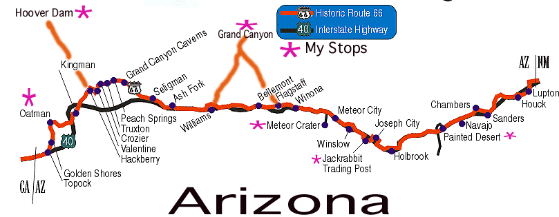
Route 66 enters Arizona as a frontage road to Interstate 40. While I-40 has ran over a great deal of Route 66 in Arizona, Route 66 is still preserved by several impressive stretches of road (see picture) away from the Super Slab.
Santa Fe, NM - Grand Canyon 470 miles
Sneak Peek Eastern Arizona
Follow I-40 to
Petrified Forest National Park & Painted Desert is a nice place to visit. Route 66 use to pass right through the park. You can visit the park or continue on I-40 Exit 289 (Holbrook). Route 66 remnants flirt with I-40 for this stretch of interstate.
Use I-40 from Holbrook to Exit 277 and visit the Jack Rabbit Trading Post (Exit 269). You must reenter I-40 here and continue to Winslow.Winslow (Harvey House ??)
The Eagles enjoyed traveling through this town and wrote a song, so come and visit. Take the AZ 87 exit (Exit 257) and follow BUS I-40 through town with the railroad tracks on your left side.
On the westside of Winslow, rejoin I-40 and head west. You can visit Meteor City and the Meteor Crater (Exit 233). At Exit 230 is the Two Guns Ruin and an old Route 66 bridge across Canyon Diablo. Continue on I-40 west. The Twin Arrows Trading Post is at Exit 219.I-40 pretty much nuked Route 66 from the east state line to Flagstaff and onto Ash Fork.
At Exit 211, pass through Winona (immortalized by Bobby Troup) you can enter Flagstaff the scenic way with Mt. Humphreys in front of you. Follow CR 394 to US 89. Turn left and enter Flagstaff.
Route 66 passes through this beautiful town on top of the Kaibab Plateau with the Santa Fe Railroad to the south. Visit the Museum Club Route 66 on Route 66. Follow Santa Fe Blvd. to Milton Road (US 180)
SEE MAP
Continue on US 180 (to Grand Canyon) to junction of US 180 & AZ 64, continue North to Grand Canyon.After visiting the Grand Canyon, go South on US 180/AZ 64. When the two routes "split", continue South on AZ 64.
I-40 has destroyed a great deal of Route 66. But, the Kaibab National Forest has developed a biking/hiking trail for you to travel some of the original Route 66 alignments.
Coming from the Grand Canyon, you will enter Williams from the North via AZ 64. The road splits into one-way streets with westbound traffic on Railroad Ave. and eastbound on Bill Williams Ave.
Williams, AZ via
AZ 66 Needles, CA 170
miles @ 20 mph = 8.5 hours
(pictures
/ description)
Williams to Ashfork
Map
Continue West on I-40 to Exit 146 (Ash Fork). Exit and go north of I-40 through the town. Rejoin I-40 at Exit 144 and continue 5 miles to Exit 139.Follow Crookton Road on the north side of I-40. The interstate will disappear finally. Continue on to Seligman. Visit Delgadillo's Barber shop while there!
Ashfork via Seligman/Peach Springs to Kingman
Continue on AZ 66 west.
MapThis section offers one of the two get the heck away from the Interstate sections of Route 66 found in Arizona. You'll visit such places as Peach Springs, home of Grand Canyon Caverns, Valentine, and Hackberry.
Kingman
Follow BUS I-40 through Kingman. In downtown Kingman, look for 1st St. Just after 1st St. turn left at the Y and follow Route 66 along the railroad. Continue onto McConnico and I-40.Kingman via Oatman & Top Rock to Needles, Ca.
(pictures / description)
|
CLICK TO SEE MAP Cross I-40 at Exit 44 and pass the entrance of I-40 to the junction with Oatman Road (Either AZ 66 or CR 10). Turn left and go up to Oatman.
The original alignment of Route 66 headed west from Kingman to Oatman
(pictures)
The hills were so steep that climbing to Oatman required going in reverse in the Model T's of yesteryear. From Oatman, you travel down the Old National Trails Highway (bearing left at the Y 2 miles past Oatman) to Golden Shores. Follow CR 10 (Oatman/Toprock Highway) south to Topock and cross the Colorado River using I-40. |
New Alignment
This alignment basically become I-40 between Kingman and Topock.
|
|
State Association
Historic Route 66 Association of
Arizona
P.O. Box 66
Kingman, AZ
Anita Leeming (520) 753-5001
Email: azrt66@kingman.com
