

In the Grapes of Wrath, the Joad family stopped along the banks of the Colorado happy to be in California yet still feared crossing the great Mojave Desert. Needles is on the eastern terminus of Route 66 in California while the great Pacific Ocean ends Route 66's journey west.
Route 66 is well preserved in
California with most of it drivable.
Needles, Ca. to Victorville, Ca. Victorville, Ca. to Santa Monica, CA
Interactive Map
| I have made two sets of instructions for California.
Although the instructions of each are similar. . . the accuracy of either
are yet to be determined.
The second set of instructions: https://www.angelfire.com/wv/joyrde/Rte66/california/need2barts.html are more detailed and included an "interactive" map. The map will take you to several web pages which include a "slideshow" of California Route 66 |
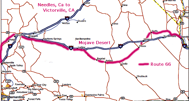
Route 66 crossed the Colorado River several ways. The pipeline crossing (see picture) was one as well as the railroad bridge that exists. Unfortunately, I-40 has run over US 66 on the California side of the river.To get on Route 66, take Exit 5, pass under the Interstate, to Old National Trails Highway. Follow Old National Trails Highway right to U.S. 95.
In Needles, follow Broadway through town. The historic alignment followed Front St. (along the railroad) and jogged around the business district from Front St. to F St., immediately right one block to G St., back the Front St. and then to Broadway. At this point you pass under the railroad bridge and follow Broadway to River Road. Turn left towards the Interstate, pass under the Interstate, turn right at the Y and follow National Trails Highway. It will pass under the Interstate one more time.
After leaving Needles, make sure you watch for National Trails Highway leaving to the left. Here you must join I-40.Between Needles and Essex, several alignments existed.
The original route exited I-40 with US 95. Follow US 95 to Arrowhead Junction and take the left turn onto Goffs Rd. You'll cross I-40 once again (say good-bye, because you finally get a nice stretch of non-Interstate Route 66) and rejoin National Trails Highway and continue on to Essex.The newer alignment requires you to stay on I-40 till you get to the Mountain Springs Rd Exit. Pass under the Interstate and follow National Trails Highway to Essex.
National Trails Highway is Route 66 for this long stretch through the desert. You'll pass through towns such as Chambless,Amboy --- Long download. . but worth the wait!!! Roy's Cafe Amboy Crater - Be sure to "click" on links - especially "Hole-in-the-Wall"
Wanna explore???the site of Bagdad Cafe - Breakfast ??? near Ludlow - I-40 shows back up
Pass under I-40 outside Ludlow to the north side of I-40. Follow National Trails Rd westward. You'll have to cross I-40 to the south at the Lavic Rd crossover. Continue west to Newberry Springs on National Trails Road.On the west side of Newberry Springs, you cross I-40 once again and follow the Burlington-Santa Fe to Daggett. On the west side of Daggett, you'll have to detour around a Marine Base by using I-40 via Nebo Rd. Exit I-40 at the exit for the Marines Logistics exit, pass under the Interstate and turn onto Main St. (south frontage road of I-40).
At Montara Rd, pass north over the Interstate and follow Main St. into Barstow (Business I-15 after I-15). Follow Main St. through town to Lenwood.
From Barstow, Main Set. becomes National Trails Highway again. You'll pass through the town of Hodge, Helendale, Oro Grande to Victorville. Pass under I-15 in
Victorville (Roy Rogers Museum) to downtown.
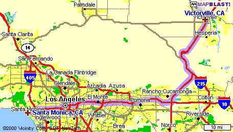
Leave Victorville on 7th St. (SH 18). Get on I-15 and head south. Cross Cajon Pass. Through the pass, remnants of US 66 are visible through the pass. You can exit at Cleghorn and drive a few miles of Route 66 via Cajon Blvd. You must rejoin I-15 at Kenwood Ave. Exit onto I-215 (left lanes) and immediately exit onto Devore Rd. Turn right and then left onto Cajon Blvd. Veer right at the Kendale/Cajon Blvd. intersection, and pass under the railroad tracks and stay on Cajon Blvd. Get on Mt. Vernon and head south.
At Mt. Vernon and 5th St., turn right (west). This is California Rt. 66 now. 5th St. becomes Foothills Blvd.Follow California 66 (Foothills Blvd.) west across the Los Angeles Basin.
Route 66 Visitors Center and Museum in Rancho Cucamonga.
Follow California 66 (Foothills Blvd.) to La Verne. Foothills Blvd. turns into Alosta Ave. and then Hungington Dr.
On the west side of Arcadia look for Colorado Pl and veer to the right. You will approach I-210 but remain on Colorado. It will veer left and then right. In Pasadena, follow Colorado Blvd. to Arroyo Parkway. Turn left and head south. Arroyo Parkway becomes the Pasadena Freeway. After I-5 move to the right most lane and exit onto Sunset Blvd. Head north on Sunset Blvd. to Manzanita Rd, 3 miles away. Turn left into Manzanita Rd which turns into Santa Monica Blvd.
Follow California 2 (Santa Monica Blvd.) into Santa Monica. There is a plaque in the park overlooking the Pacific Ocean in tribute to Will Rogers and the Will Rogers Highway, Route 66.
Route 66 ends its journey west from Chicago to the Pacific Ocean.
Route 66 played an important
part in moving people from one end of the country to the other. Work to
preserve it and it's importance to our country's history.
