A Thousand and One Appalachian Tales
part three
Smoky Mountains
33. The Great Smoky Mountain National Park(GSMNP, Gatlinburg, Tenn. 37738; 704-498-2327). Shelters in the Smokies are stone cabins with dirt floors and chainlink fence across the front and wire bunks inside. The bunks can be murder on sleeping bags so use a pad between them, The fence and gate are to keep bears out: try to maintain that arrangement by not leaving the gate open when you are cooking. Skunks frequent the shelters: they come in, make their appointed rounds, then depart. Try not to aggravate them. Horses and riders sometimes at shelters can be a nuisance. Few blazes in the Smokies. Park Service says it is to preserve the wilderness experience. Be careful and look closely at trail junctions.The 1988 Philosopher's Guide, pg 18
©Copyright 10/16/02000. Fresh Ink. All rights reserved
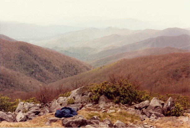
From the end of Fontana Dam, the Trail turned right. It followed the road briefly then turned left into the woods. After a pleasant, invigorating ascent up Shuckstack ridge, Düg and AT blue-blazed it to the summit of Shuckstack Mtn (4,020 ft) for fantastic views in all directions. To the south sat, Fontana Lake and to the northeast, Clingman's Dome. Like ravenous shutterbugs they scurried about snapping pictures before continuing on to Doe Knob (4,520 ft) and the main crest of the Great Smokies. Then, after a steep descent to Ekaneetlee Gap, the Trail ascended another mile to Mollies Ridge Shelter where they spent the night.
At Mollies Ridge, Düg encountered the Great Smoky Mountains Shelter System for the first time - great stone lean-tos with chain link fences over the front and chain link gates for doors. They begged the question, were they to keep the bears out or the hikers in? Inside, it was as if someone found a really great deal on chain link fence and perhaps purchased a bit more than was needed. With the excess they fashioned bunks. These were treacherous to say the least. Düg managed to rip both his new bag and his Therm-a-rest self-inflating air mattress all in the first few days. He was able to sew his bag, which added great distinction and character, but the Therm-a-rest lasted about as far as Hot Springs before he traded it in for the ever faithful, puncture proof, Ridgerest closed-foam pad. He just couldn't patch all the tiny holes those wire bunks made.
Also at the shelter that night were AT, Steve Trailnameless, Strider, Zero and the Sandbaggers. Each of these fellow northbounders were utterly unique individuals. Trailnameless was a marathon runner form California, Zero a computer programmer from New England, AT a shutterbug from Illinois, and Strider was, well... Strider. He had thru-hiked the Trail a few years before and was a veritable Encyclopedia Britannica on all things Appalachian. He knew everything. Many took copious notes. As for the Sandbaggers, they were like a comedy duo at the Improv. They had a wry sardonic wit that cannot be captured here. Indeed, none of these people could ever be reduced to words or simple descriptions. They were like X-Men, mutants with special powers. They were wholes so entwined in the moment that they were inseparable from it. Düg was very fortunate to have had the pleasure of such fine company.
That night everyone poured over their Trail Guides and maps. But while these were good to have, the Data Book was probably the most essential, at least in terms of logistics and planning. The Data Book provided all the mileages between peaks, shelters, Trail towns, and more. It compressed the information of the Trail Guides into a format ideal for devising suitable strategies in various conditions such as sudden changes in weather and plotting one's course between towns and re-supply points. The Trail Guides and Data Book were good to have when you needed them. However, the Philosopher's Guide was arguably most important in terms of everything else. When you weren't lost, in need of a Trail description or the mileage to the next shelter or town, the Philosopher's Guide was an invaluable resource. It helped to make the Trail lots of fun. We are saddened to learn that Maret - The Philosopher - no longer publishes his guide. For those who will no longer be able to benefit from his collection of tips and assorted comments, you have missed a treasure trove of Trail-related trivia and information. It was truly the thru-hiker's bible. Next to the Data Book, the Philosopher's Guide was the most valuable book to have on the Trail.
The next day, as everyone packed up, the Sandbaggers kept to their strict regime of sandbagging through the morning. They, of course, were the last to leave.
Düg began his day crossing Devils Tater Patch (4,775 ft). From there he and AT followed along the open grassy Ridgecrest. They continued over Rocky Top (5,441 ft), Thunderhead (5,527 ft), and Cold Spring knob (5,240 ft) to Silers Bald Shelter. This put them 4.4 miles from Clingman's Dome, the highest point on the Appalachian Trail.
During the day they began to notice plenty of blowdowns. Travel was becoming increasingly difficult and even a little dangerous as the Trail passed through thick regions of balsam and red spruce, all near flattened by a recent storm. Later, in Hot Springs, Düg would learn that the fierce storm which had awoken him on Springer Mtn had caused all this devastation.
Düg and AT reached Cold Spring Knob around sunset and stumbled into Buckeye gap around dusk. It was getting dark when a flashlight fixed them in it's sights. This, it turned out was taped to the end of a rather large shotgun. Thankfully, the gun was in the hands of a Park Ranger. He explained he was out hunting wild hogs which came out at dusk.
Apparently, in the 01940's several wild boar escaped from a private game preserve on Hoopers Bald in what is now the Nantahala National Forest. Before these animals could be caught, they interbred with domestic pig stock, to produce hybrid wild hogs which then spread to the Smoky Mountains. They are considered an exotic species, in that they are not indigenous to the area. It was left to the Park Rangers to dispose of them. In 01986, the National Resources Preservation Program provided funding for their removal. Prior to that time over 2,000 hogs inhabited the park. Today that number is down to a few hundred. Ironically, as a sign of hybridization, some of the hogs had white blazes on their faces.
Düg and AT said good night to the Ranger and continued on. They passed through a gated fence, used as part of the removal program, then continued on the last few hundred yards to Silers Bald Shelter for the evening.
Later that night, reading the Trail Register by candle light, Düg had to laugh. There were special poles outside the shelters for hanging food bags. These were designed to keep food items away from the bears and other wildlife. However, a thru-hiker had decided to keep her food inside instead. The next morning, they awoke to find a bear camped out right in front of the door! It wouldn't let them leave. They were trapped inside until rescued by another hiker who happened along.
The next day the Trail crossed the crest of Silers Bald (5,607 ft), with many magnificent early morning views, then descended into madness. Almost everything which was once vertical was now horizontal or nearly so. It was slow going and treacherous. Nothing had been cut away and to continue along the Trail required climbing over hundreds of toppled trees.
Eventually, Düg, Zero, Strider and AT made it to the summit of Clingman's Dome (6,643 ft). There, an observation Tower stood head and shoulders above the pine. From the deck were many fine views of the surrounding forests, all toppled like so many Dominoes.
While they surveyed the devastation below, a decision was made to avoid the further peril of these blowdowns. As the Trail pretty much followed the road all the way to Newfound Gap, they discussed following the road instead. To Zero and AT, this did not seem like the Purist thing to do. However, after careful consideration, it was determined to be an acceptable deviation from certain popular notions of thru-hiker purity. There was even a passage in the guide book suggesting this as an alternate route. That seemed to somehow legitimize the argument. In the end, they took the road to Collins Gap. There they re-joined the AT and followed this a short distance further to Mt Collins Shelter for the evening.
Day 22: The day began with a return to Clingman's Dome Road to avoid further blowdowns. They followed this to Newfound Gap where they again re-joined the Trail. They continued on past Ice Water Spring Shelter to enjoy a magnificent encounter with Charlies Bunion. This was a visually stunning section of the Trail. Views to the west, of Mt Kephart, merged seamlessly with views to the northwest, of Mt LeConte, and to the east, of the jagged knifelike section, through which they would be traveling next, the Sawteeth Range. The Sawteeth were a rugged narrow crest which passed along the border of North Carolina and Tennessee. From the crisp vantage atop Charlies Bunion the Trail could be seen to weave back and forth across the Stateline like dental floss.
Finishing up a leisurely romp around the rocky delights of Charlies Bunion, the group descended briefly into Dry Sluice Gap before following along the sharp crest of the Sawteeth. After a descent through Porters Gap, they progressed onward to the crest of Porters Mtn. They descended into False Gap then climbed steeply around the side of Laurel Top (5,865 ft) to Bradleys View. This was yet another breathtaking vista. There, they were afforded an excellent vantage from which to gaze down into the deep-cut gorge of Bradley Fork which flows into the Oconaluftee River.
Late in the afternoon, they continued on a short distance further to Hughes Ridge and the trail junction which led to Pecks Corner Shelter for the evening.
 April 28th: After a late start, Düg began his day with an ascent to the summit of Mt Sequoyah (6,000 ft). There he ran into AT, Strider, and Zero enjoying a late morning siesta. Their vortex was inescapable.
Later, he pressed on through virgin balsam and spruce. Thankfully, the damage was not as severe though here and he was able to continue on to Tri-corner Knob Shelter with little difficulty. There, he stopped to read the Trail Register.
From the shelter it was barely .2 miles further to Tri-Corner Knob. This was the junction of two major mountain ranges, the Smoky Range and the Balsam Range. Continuing on he was rewarded with breathtaking vistas of Hell's Ridge. He crossed Guyot Spur then began a laborious ascent up the north slope of Mt Guyot (6,621 ft). This was the second highest peak in the Smokies and the faint, hard to follow Trail was made all the more difficult by numerous blowdowns. At the summit he ran into Zero, AT and Strider where they stopped to have lunch. Together they continued on to Hell's Ridge. This was an area that had been devastated by a massive forest fire. It was getting late so they did not linger. After passing through Deer Creek Gap, Yellow Creek Gap, and Camel Gap, they reached Cosby Knob Shelter for the evening.
There, they met another hiker who was passing through heading south. The hiker boasted of having hiked all over the world, in the Andes, the Himalayas, along the Continental Divide, as well as the AT. He seemed to know a thing or two. But after he left, the others were quick to say they didn't believe a word of it because he was hiking in sneakers. A debate ensued. Düg did not know whether the hiker had been to any of the places he spoke of or not. But he did not believe that boots, or lack thereof, were a suitable criteria by which to judge someone's long distance hiking capabilities. He felt that equipment, and/or attire, did not necessarily dictate distance. Sure, equipment was important over the short term, for creature comforts such as food, clothing, and shelter, but none of these were essential to long distance hiking per se. They did not hike the Trail, they only made the Trail more enjoyable to hike, at least in theory. You did not need rain gear in the rain but it certainly helped. He did not need to carry a twelve pound tent so he went without one.
The tent could have made the Trail more enjoyable by alleviating crowded shelter stays but it would have made it unbearable in terms of weight. Keeping it light was, in the long term, more important than gear was in the short term. Indeed, keeping it light was what it was all about. Some people even went to extremes to cut off the ends of toothbrushes and to remove the cardboard roll from toilet paper, all in an effort to reduce weight.
So Düg did not place as much emphasis on gear when it came to defining such enigmas as thru-hikers. To him, Long Distance Hikers, such as he was coming to know them, were something much more complex, something which could not be reduced to a collection of parts. He felt it was the contents of one's mind which had a greater bearing on Long Distance Hiking than the contents of a backpack, or the shoes on one's feet.
The next day began with a blue-blazed side trail to the summit of Mt. Cammerer (5,025 ft). At the summit was a stone tower which offered a spectacular 360 degree panorama of the Smokies. This was one of the finest views along the entire Trail. From there, it was an easy hike downhill to Davenport Gap Shelter. As this was the last shelter in the Smokies, he decided to stop there for the evening.
It was a tranquil, bittersweet night yet a restlessness gripped him. Despite the many blowdowns, he had enjoyed these rugged, hardy mountains and did not know if he would ever pass this way again. He didn't want the moment to end. He wanted to hold on to it, to preserve it forever. The Smokies were a rare and precious gem and too quickly they had passed and were gone.
This melancholy was nothing new to him, he had experienced it before. There were the friends he left behind in Germany, and the friends he left behind in Texas. These were people who, in all likelihood, he would never meet again. At every place he had ever been to he left behind someone or something he would never see again. This knowledge filled him with a strange sense of sorrow and loss. It left him with the realization that no matter how much he wanted too, he could not take it with him. He could only leave it behind.
He was finding that the Appalachian Trail was no different. It was an inexplicable aspect of the entire Trail, woven into every step.
©Copyright 10/16/02000. Fresh Ink. All rights reserved
"Take with you only memories, leave behind only footsteps"
Return to the International Peace Trail Project