
< US 25E | Home | US 33 > | ||||||||||||||||||||||||||||||||||||||
|
|
|
| ROUTE LOG |
NC STATE LINE, US 29 Bus, US 58 WB, VA 785 BEGIN: 0 - 0 VA 86: 3.5 - 3.5 US 58 EB, US 58 Bus, US 360, VA 785 END: 3.75 - 7.25 VA 360: 1.75 - 9 PI-DAN LINE: 0 - 9 US 29 Bus: 4 - 13 US 29 Bus: 6 - 19 VA 57: 1 - 20 US 29 Bus: 2 - 22 US 29 Bus: 6 - 28 VA 40: 2 - 30 US 29 Bus: 2 - 32 US 29 Bus: 8 - 40 CB-PI LINE: 3 - 43 VA 43: 1 - 44 US 29 Bus: 3 - 47 VA 24: 9 - 56 US 460: 6 - 62 LYN-CB LINE: 0 - 62 VA 368: 0.75 - 62.75 US 29 Bus, US 501 NB: 0.75 - 63.5 US 501 SB, VA 128: 0.25 - 63.75 US 221, US 460 Bus, US 501 Bus: 2.75 - 66.5 AM-LYN LINE: 1.5 - 68 VA 210: 0.75 - 68.75 US 29 Bus: 0.75 - 69.5 US 29 Bus: 0.5 - 70 VA 130: 2 - 72 US 29 Bus: 8 - 80 US 60: 2 - 82 US 29 Bus: 1 - 83 VA 151: 2 - 85 NL-AM LINE: 5 - 90 VA 56 WB: 6 - 96 US 29 Bus, VA 56 EB: 4 - 100 US 29 Bus: 1 - 101 VA 6 WB: 7 - 108 VA 6Y: 0.5 - 108.5 VA 6 EB: 4 - 112.5 AL-NE LINE: 1 - 113.5 I-64 (exit 118): 18 - 131.5 US 29 Bus: 0.5 - 132 US 250 WB, US 250 Bus: 1.5 - 133.5 CHA-AL LINE: 1.5 - 135 US 29 Bus, US 250 EB: 0.5 - 135.5 AL-CHA LINE: 0.5 - 136 GR-AL LINE: 10 - 146 US 33: 4 - 150 MA-GR LINE: 4 - 154 VA 230 WB: 5 - 159 VA 230 EB, VA 231 SB: 1 - 160 US 29 Bus, VA 231 NB: 1 - 161 US 29 Bus: 2 - 163 CP-MA LINE: 7 - 170 US 29 Bus, VA 299: 8 - 178 US 15 SB, US 15 Bus: 0.5 - 178.5 US 522, VA 3: 1.5 - 180 US 15 Bus, US 29 Bus: 4 - 184 US 15 Bus, US 29 Bus: 7 - 191 FQ-CP LINE: 0.5 - 191.5 US 15 Bus, US 29 Bus: 2 - 193.5 VA 28: 0.5 - 194 US 17 SB: 4 - 198 US 15 Bus, US 17 Bus, US 29 Bus: 5 - 203 US 15 Bus, US 17 NB, US 29 Bus: 4 - 207 VA 215: 6 - 213 PW-FQ LINE: 1 - 214 US 15 NB: 1 - 215 VA 55: 3 - 218 I-66 (exit 43): 0.5 - 218.5 VA 234: 4 - 222.5 FX-PW LINE: 1 - 223.5 I-66 (exit 52): 4 - 227.5 VA 28: 0.75 - 228.25 FFX-FX LINE: 5.5 - 233.75 US 50 WB, VA 236: 0.25 - 234 VA 123: 1 - 235 US 50 EB, VA 237 WB: 1.75 - 236.75 FX-FFX LINE: 0 - 236.75 VA 243: 1 - 237.75 FAL-FX LINE: 3.75 - 241.5 VA 338: 0.25 - 241.75 VA 7: 0.25 - 242 AR-FAL LINE: 0.5 - 242.5 I-66 (exit 68): 0.25 - 242.75 VA 237 EB: 0.25 - 243 VA 120: 2.25 - 245.25 VA 309: 0.25 - 245.5 VA 309: 0.5 - 246 I-66 (exit 72): 0.25 - 246.25 VA 124: 0.25 - 246.5 I-66 (exit 73): 0.25 - 246.75 I-66 (exit 74): 0.5 - 247.25 GW PKWY: 0.25 - 247.5 DC LINE: 0.25 - 247.75
|
Creation: US 29 was an original US Highway, but it did not come to Virginia until 1932. In general it ran as it does now from Danville to Culpeper. It replaced all of US 170 from NC to Lynchburg, VA 18 from Lynchburg to Charlottesville, and VA 28 from Charlottesville to Culpeper.
| Adjustments: In 1933, US 29 was straightened out between Charlottesville and Ruckersville, leaving behind SR 743 and Earlysville.
Also in this timeframe, US 29's Charlottesville routing was altered, from using Rugby Rd to today's Emmett Dr.
US 29 was extended in 1934 to Washington DC on its way to Baltimore, MD. From Culpeper to Warrenton was a multiplex with US 15, and from Warrenton to Washington, a multiplex with US 211. In 1948, US 29 was realigned between Amherst and Lovingston to its current routing. Previously, US 29 ran from Amherst to Piney River, then east to Lovingston. This alignment became VA 151 to Piney River, and VA 158 from Piney River to the Colleen area (curr VA 151Y and VA 56). The new US 29 alignment was a replacement for VA 150 and some new construction.
In 1955, US 29 was rerouted in Lynchburg north of US 501 (curr US 501 Bus Campbell Ave). US 29 went south along US 501 to meet the new road built over the James River (curr US 29 Bypass). The second VA 130Y was swallowed by this new alignment, as well. The old route became an extended US 29 ALT (today it is US 29 Bus).
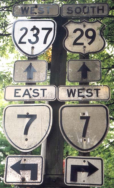
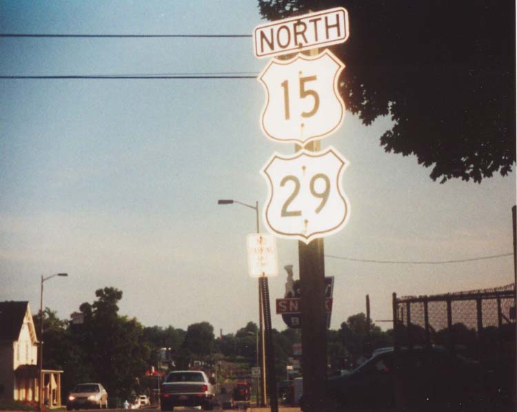
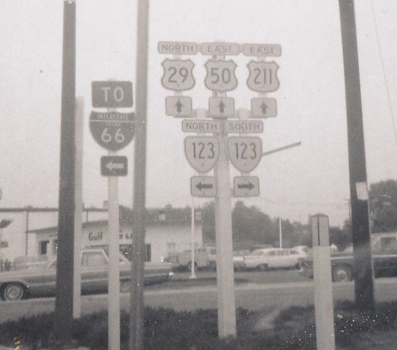
Between 1960-61, US 29 and VA 309 swapped alignments where they met at Lee Hwy and Old Dominion Dr., such that VA 309 used Lee Hwy for 3/4 mile. In 1981 the US 211 multiplex was removed from US 29. About 1998, US 29 in the Danville area was rerouted as a freeway bypass east of Danville was completed. This was part new construction and a full replacement of VA 265. The previous US 29 Bypass route became US 29 Bus and the original US 29 Business became VA 293. In late December 2004, the first couple miles of the Madison Heights Bypass opened, to the VA 210 connector. The freeway is signed as TO US 29. Posting: Fully posted; cutouts remain in Falls Church, Madison, Culpeper . Check out this Fairfax cutout from 1969! New US 29 signs at Stringfellow Rd. (Centreville) say E-W rather than N-S. Bonus error: In Jan 2003 I saw two error FLA 29 signs in Pensacola. Comments: One of the most important north-south routes in VA, important enough that it's rumored to be in line for an Interstate upgrade - maybe to I-785 (and you thought I-476 was too long for a 3di). All of US 29 in VA is four lanes or greater except for a short section in Manassas National Battlefield. In Fairfax you can stop at the Tastee 29 Diner, which curiously was not named for the more important and older US 50. In the 30's and 40's there was a VA 29 loop similar to the US 360-VA 360 setup between Culpeper and Warrenton. A US 29 Bypass of Madison Heights is under construction, with talk of opening the US 460 to VA 130 section soon. US 29 from NC to Warrenton (using US 29 Bus routes) has been legislatively named the Seminole Trail since 1928. To take a closer look at US 29, visit Adam Prince's excellent site detailing the Seminole Trail and Lee Hwy. |
|||||||||||||
| US 29 ALT Decommissioned | ||||||
| Previous US 29 ALT's: |
US 29 ALT #1: Appeared between 1934-37. Originally began at US 29-VA 86 jct in South Danville and ran north across the river along Worsham St. It met up again with US 29 (curr VA 293) just south of US 360 (curr VA 360). In 1938 US 29 ALT was extended south to meet US 29 a mile below VA 86. Also through Danville south of the river it was rerouted along different streets. Too complex to describe, so I will try to get a scan here. This US 29 ALT was eliminated between 1942-44. Today some of this is VA 293.
US 29 ALT #2: Created between 1942-44 in the Danville area. This was a bypass on the west side of Danville. It ran from the original US 29-VA 125 jct south of town to US 29 (curr VA 293) north of VA 41. The first mile or so seems to be a replacement of VA 125. This was changed to US 29 Bypass in 1971 or 1972. US 29 ALT #3: Appeared between 1945-47. Was Fort Ave. and 12th St. in Lynchburg from US 29 Memorial Dr. to Main St. then north to US 29 at the James River Bridge. This was previously unnumbered below Campbell Ave and a multiplex with US 501 ALT. In 1955, US 29 ALT was extended to Madison Heights, as US 29 moved to the Lynchburg Expwy over the James River, and ran on separate one-way streets (NB used the previous 29 ALT, SB used today's US 29 Bus). See the 1955 change scans for mainline US 29 above. US 29 ALT northbound within Lynchburg was renumbered as part of VA 128 in 1956. (Today it is largely unnumbered save a small piece of US 221-460 Bus.)
In 1960-61 US 29 ALT was extended south to the new US 29 freeway extension, just below VA 128. See scan immediately above. In 1971 or 1972 all of US 29 ALT became US 29 Bus. US 29 ALT #4: Appears in the July 1960 and April 1961 CTB Minutes as the proposed number for the Chatham Bypass, which was completed about 1965. I do not know if it was posted as such or US 29 Business. |
|||||
Previous: US 25E |
Next: US 33
Top | Virginia Hwy Index
Home


