 |
From: US 15/29 Remington, Fauquier County
To: VA 7 Sterling, Loudon County
Current Length: 49 miles |
|
|
|
|
ROUTE LOG
US 15, US 29: 0 - 0
US 17: 2 - 2
PW-FQ LINE: 14 - 16
VA 215: 5 - 21
VA 234: 2 - 23
MAN-PW LINE: 0 - 23
VA 234 Bus: 2 - 25
PW-MAN LINE: 1 - 26
MPK-PW LINE: 0.5 - 26.5
VA 213: 0.5 - 27
PW-MPK LINE: 0.5 - 27.5
FX-PW LINE: 2 - 29.5
US 29: 2.5 - 32
I-66 (exit 53): 0.5 - 32.5
US 50: 4 - 36.5
LN-FX LINE: 6 - 42.5
VA 267: 0.5 - 43
VA 209: 0.5 - 43.5
VA 7: 5.5 - 49
|
|
Creation: an original state highway - one of only 2 that remain. VA 28 ran like this in 1922, running from VA 18 (curr US 29 Bus) Lovingston to VA 9 (curr US 250 Bus) Charlottesville, via Shipman, Rockfish, and Covesville (to do this today would be VA 56, SR 639, SR 632, US 29). So none of today's VA 28 includes its original routing.
Adjustments: Between 1924-27, VA 28 acquired a second piece, from VA 21 (curr US 15-29) New Baltimore to VA 21 (curr US 29) Centreville via Manassas. This piece had been the original VA 211. Also, the original VA 28 piece had its south end changed to Woods Mill (still ending at VA 18 at the current US 29-VA 6 jct), using today's US 29 corridor. The old route through Rockfish went unnumbered.
In 1928-29, the southern piece was extended north through Ruckersville, Madison, and Culpeper to the Rappahannock River at Jeffersonton, over unnumbered routes. Today this is SR 743, US 29, VA 229, and SR 802.
In 1932, US 29 appeared in Virginia, eliminating all of the southern piece of VA 28 except Culpeper to Jeffersonton. Alas, this remaining section was renumbered to VA 29 in July 1933.
By July 1936, VA 28 was back to being a 2-piece route, when a piece that only went from one side of Herndon to the other appeared, over a previously unnumbered road. Today this would be part of VA 228. In 1938 this piece was extended north to VA 7.
By 1941, VA 28 was moved from its New Baltimore end to its current end in Remington. This replaced part of VA 233 and left behind VA 295 in its old path (curr VA 215).
In 1962 the southern piece extended north to US 50 replacing part of SR 657. In 1967 the northern piece was renumbered as VA 228 and the southern piece was extended to VA 7 as it is today. The northern piece was never connected to the rest of VA 28.
Posting: Fully posted. Last cutout removed from Manassas Park when they redid the VA 28-213 intersection.
Comment: The six lane superhighway of western Fairfax County. Also the site
of a lot of overbuilt, underused roads to nowhere (see VA
209). Three years ago VDOT dropped the speed limit to 45 mph from Remington to Manassas. This seems extremely slow when driving through the rural country out there.
|
| VA
29 not currently assigned |
|
|
|
|
| Previous VA 29's: |
|
VA 29 #1: Appeared in 1923. Ran from Gloucester Pt. to VA 30 (curr. VA 33) near West Point. This had been one of the original VA 9 Spurs. Today this is US 17 and VA 14. In 1927 it's entire route was part of US 17, but was saved from elimination when a direct US 17 opened up in 1929 from Gloucester to Saluda.
In 1929 VA 29 was extended north to 3 miles north of VA 13 (curr US 360) St Stephens Church. This eliminated the original VA 131. Also VA 29 south was truncated to Adner (curr US 17-VA 14 split).
In 1930-31, a second piece of VA 29 appeared, from VA 50 (curr US 301-VA 2) near Bowling Green to 5 miles SE. This was not previously numbered. Additionally, the southern piece was extended further north to near the Caroline County Line.
VA 29 was renumbered in its entirety to VA 14 in July 1933.
VA 29 #2: Created in July 1933 as an odd US route extension for US 29. It ran from Culpeper to Warrenton via Jeffersonton, replacing the southern section of VA 28. Today this is VA 229 and SR 802, which replaced VA 29 between 1948-51. This must have been confusing. The VA 360 of its time.
|
 |
From: US 1 Doswell, Hanover County
To: SR 607 Norge (at I-64 interchange), James City County
Current Length: 65 miles
|
|
|
|
|
ROUTE LOG
US 1: 0 - 0
I-95 (exit 98): 1 - 1
CL-HN LINE: 1 - 2
US 301, VA 2: 5 - 7
KW-CL LINE: 5 - 12
US 360: 12 - 24
VA 33 EB, VA 298: 24 - 48
VA 296: 0.5 - 48.5
NK-KW LINE: 0.5 - 49
VA 273: 1 - 50
VA 33 WB, VA 249: 3 - 53
VA 273: 3 - 56
JC-NK LINE: 1.5 - 57.5
I-64 (exit 227): 1.5 - 59
US 60: 2 - 61
SR 607: 4 -65
|
|
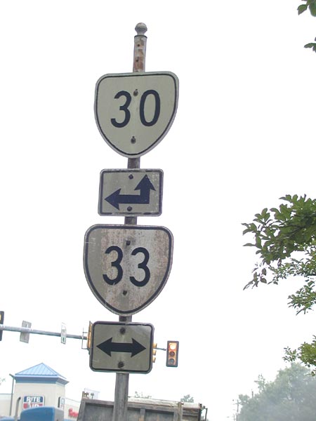
Creation: Appeared in 1923. Began at VA 13 (curr. US 360) in Central Garage and proceed through West Point and Saluda to end in the town of Urbanna. This was mostly new routing except West Point to VA 29 (curr VA 14 EB), which was part of an original VA 9 Spur. This would be today's VA 30, 33, and 227.
Adjustments: In 1929, VA 30 was extended west over unnumbered routing to Mangohick.
In 1930-1931 VA 30 was extended west again to the Caroline County line over an unnumbered road.
In July 1933 VA 30 went westward to VA 2 Dawn, and the east end was moved from Urbanna to US 60 near Toano, replacing the original VA 53. The original VA 30 east of West Point became VA 4 (curr VA 33) and VA 227. Also in July 1933 a discontinuous segment appeared from VA 51 (curr. SR 738) to Louisa Couty, west of Beaverdam, replacing VA 428. This is curently SR 739. Between 1942-1944, the west segment was renumbered as VA 51Y.
In 1971-72 VA 30 was extended west to US 1 over SR 652, and also VA 79 #3.
In 1980 VA 30 was extended to its current eastern end, replacing VA 168Y. In 1986 VA 30 was moved to its alignment between Barharmsville and West Point, replacing part of VA 249. Old VA 30's route became VA 273.
Posting: Fully Posted; Cutout still up in West Point (from VA 298).
Comments: A good alternate to bypass beach traffic from Williamsburg to Fredericksburg.
|
 |
From: US 460 Wakefield, Sussex County
To: VA 5-199 Williamsburg, James City County
Current Length: 24 miles (plus 3 more on a ferry)
|
|
|
|
|
ROUTE LOG
US 460: 0 - 0
SU-SX LINE: 1 - 1
VA 10 WB: 14 - 15
VA 10 EB: 1 - 16
Scotland Ferry Terminal: 4 - 20
JC-SU LINE (ferry): 1.5
Jamestown Ferry Terminal (ferry): 1.5 - 20
VA 359: 0.5 - 20.5
VA 5, VA 199: 3 - 23.5
|
|
Creation: Appeared in July 1933 as the 2nd VA 31. Originally ran from 3 miles south of Wakefield to Camp Magruder. This replaced in its entirety VA 510.
Adjustments: Between 1945-47 the stub below Wakefield was downgraded to SR 628. Between 1954-1956 VA 31 was truncated to VA 168 (curr I-64 at the VA 143 exit).
In 1957, VA 31 was altered in Williamsburg to follow Henry Street north past the Reception Center for Colonial Williamsburg out to VA 168 (curr VA 143). I believe this was new alignment.
By 1961, VA 31 was changed to cut east from Henry Street along Lafayette Street to US 60, then north over the Colonial Parkway, branching off US 60 to end at VA 168 (curr VA 143). The last branching had been part of VA 162. VA 5 was added as a multiplex through Williamsburg
Finally in 1994, VA 31 was removed from the VA 5 multiplex to its current end.
Posting: Fully Posted; cutouts existed in Jamestown, Williamsburg, and Surry as late as 1993, but none remained as of spring 2005.
Comments: The ferry across the James River is a nice break during a summer drive.
. |
| Previous VA 31's: |
|
VA 31 #1: Appeared in 1923, mostly as a renumbering of VA 1. Originally ran from then-NC 75 (curr US 15) to Clarksville (really!), then east to Lawrenceville, then north to Alberta, then to Petersburg, Richmond, Ashland, Spotsylvania CH, Fredericksburg, Woodbridge, Alexandria, to DC. Today this generally would be US 15, US 58, VA 46, US 1, SR's to Snell (the routing is unclear, but did not follow VA 1's path from Ashland to Snell), SR 738, VA 208, US 1.
By 1925, VA 31 was shifted to follow today's US 1 below Petersburg (leaving behind VA 32, VA 201, and VA 122) and US 1 above Richmond (leaving behind some unnumbered routing and extended VA 312). It acquired US 1 in 1927, which totally replaced it in 1929.
|
 |
From: US 60 & US(17-258)NB, City of Newport News
To: NC state line, City of Suffolk, where the road continues as NC 32 to Washington, NC
Current Length: 40 miles (VA+NC 32= 141 miles)
|
|
|
|
|
ROUTE LOG
US 17 NB, US 258 NB, US 60: 0 - 0
IW-NNS LINE: 2 - 2
US 17 SB: 4.5 - 6.5
US 258 SB, VA 10 WB: 2.5 - 9
SUF-IW LINE: 4 - 13
VA 125: 1 - 14
US 13 NB, US 58 EB, US 460 EB, VA 10 SB, VA 32 Bus: 6 - 20
US 460 WB, US 460 Bus: 1 - 21
US 58 WB, US 58 Bus: 4 - 25
US 13 Bus, VA 32 Bus: 3 - 28
US 13 SB: 2 - 30
NC STATE LINE: 10 - 40
|
|
Creation: Appeared in 1940-41 as the 3rd in its current routing. It replaced VA 10 from NC to Benns Church. Everything else was multiplexed.
Adjustments: None really; VA 10 was re-added from Benns Church to Suffolk between 1951-53. Oddly, VA 32 is not shown on the 1951 Official Map north of Suffolk, although it is on 1947 and 1953.
In 1979, VA 32 was routed on Saratoga St. in Suffolk instead of Main St (which became VA 32 ALT).
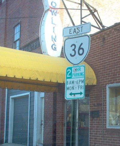
Posting: Fully Posted, but no VA 32 signs exist in Newport News. Error US 32 signs existed for several years at the split from US 17 in Suffolk, but they were finally replaced. All Suffolk cutouts were replaced by 1993 except a truck route US 13-VA 32 under the current VA 32 bridge in Downtown Suffolk. Here is a picture of a VA 32 Suffolk cutout in 1973.
Comments:runs along the edge of the Dismal Swamp. Seems to have a crush on US 17 - They intersect 3 times in NC-VA
A. Froehlig notes in June 2005 that a VA 32 TRUCK is posted at US 58 Bus at Wilroy Rd, but it is uncertain if VA 32 TRUCK is posted anywhere else.
|
| Previous VA 32's: |
|
VA 32 #1: Appeared in 1923. Ran from then-NC 75 (curr US 15)below Clarksville to Keysville, Farmville, Gordonsville, Orange, Culpeper, Bealeton, Warrenton, Middleburg, Leesburg to Maryland at Point of Rocks. Today this is approximately US 15 from NC to US 250, SR's to Gordonsville, US 15 to Locust Dale, SR's and US 522 to Culpeper, US 15 to Remington, SR's and US 17 to Bealelton and Opal, US 17 and VA 245 to The Plains, SR 628 and US 50 to Middleburg and Gilberts Corner, and US 15 to Maryland. All of this had been VA 2. Unfortunately, US 15 overran all of this VA 32 and it went away in 1929.
VA 32 #2: Appeared in July 1933 as a discontinuous route: 1. VA 35 Boykins to Purdy (nw of Emporia), replacing all of VA 534 and VA 509, 2. US 301 Jarratt east for 5 miles (not previously numbered), and 3. VA 48 (curr VA 40) Sussex to Yale (replacing VA 538). These 3 sections formed an upside down question mark.
In 1938, section 3 was renumbered as VA 308. Today it is SR 735. Also in 1938, section 1 was extended east from Purdy to just short of connecting with section 2 in Jarratt.
In 1940-41 VA 32 was needed at the NC border at Suffolk, so section 1 became VA 195 (curr VA 186) from Boykins to Branchville, VA 88 from Branchville to Purdy (currently SR 730 and SR 619) and part of VA 137 from Purdy east to short of Jarratt (curr SR 608), and section 2 also became part of the extended VA 137 (curr VA 139 and SR 631).
VA 32 ALT: Ran on Main St in Suffolk between Hall St. and Washington St. Mentioned in April 1979 CTB Minutes. It appears this was created for a project to rebuild part of VA 32 in Suffolk (VA 32 mainline was moved to Saratoga St). Main St was VA 32 before and after this project.
. |
 |
From: US 33, US 250, City of Richmond
To: Dead End - Sting Ray Pt., Middlesex County
Current Length: 73 miles
|
|
|
|
|
ROUTE LOG
US 33, US 250: 0 - 0
US 1, US 301: 0.5 - 0.5
US 360: 2 - 2.5
I-64 (exit 193): 2 - 4.5
HR-RIC LINE: 0 - 4.5
VA 156: 4.5 - 9
VA 33Y: 1.5 - 10.5
US 60 WB, VA 156 NB: 0.5 - 11
I-295 (exit 28): 2 - 13
VA 156 SB: 3 - 16
NK-HR LINE: 2 - 18
US 60 EB: 1 - 19
I-64 WB, VA 249 (exit 205): 0.5 - 19.5
VA 106 (exit 211): 6 - 25.5
VA 155 (exit 214): 3 - 28.5
I-64 EB (exit 220): 6 - 34.5
VA 30 EB, VA 249: 3 - 37.5
VA 273: 3 - 40.5
KW-NK LINE: 1 - 41.5
VA 296: 0.5 - 42
VA 30 WB, VA 298: 0.5 - 42.5
KQ-KW LINE: 0.5 - 43
VA 14 WB: 3.5 - 46.5
VA 14 EB: 2 - 48.5
GL-KQ LINE: 2 - 50.5
VA 374: 2.5 - 53
US 17 SB, VA 198: 0.5 - 53.5
MI-GL LINE: 1 - 54.5
US 17 NB, Begin US 17 Bus: 1 - 55.5
US 17 Bus NB: 0.5 - 56
VA 227: 1 - 57
VA 3 WB: 5 - 62
VA 3 EB: 3 - 65
VA 33 END: 8 - 73
|
|
Creation: Appeared in 1938, as a US highway extension. All of its original route was part of original VA 4. This is the 3rd VA 33.
Adjustments: In 1973, VA 33 was moved onto its current I-64 multiplex. The old route became VA 249. In 1982 VA 33 was moved onto the ML King bridge and away from its US 60 multiplex and 25th St. approach from the east.
Posting: Fully posted. US 33 sign east of I-95 removed in last couple years. Cutout still up in West Point (from VA 298)
Comment: VA 33's dead end near Deltaville is nowhere near as ominous looking as VA 14's. VA 33's true beginning in Richmond is not very clear. At US 1-301 it is VA 33. At the US 33-250 east split, it is all US 33.
See notes for US 33.
The 1944 Official Map Richmond inset erroneously shows VA 33 on Staples Mill Road; The 1951 Official Map reverse (historical sites map) shows VA 33 as US 33 in the West Point area
|
| Previous VA 33's: |
|
VA 33 #1: Created in 1923. Began at then-NC 709 (curr NC 14-87) to Ridgeway, Martinsville, Rocky Mount, Roanoke, Buchanan, Lexington, Staunton, Harrisonburg, New Market, Strasburg, Winchester, to then-WV 52 (curr US 11). All of this had been the original VA 3, except Lexington to Staunton was new routing (VA 3 had followed VA 39-252), and north of Winchester was new routing (VA 3 cut west to Gore).
Today this is approximated by VA 87, US 220, SR 919, US 220, and US 11.
In 1927 it acquired US 311 and US 11 as roommates for its entire length. Additionally, VA 33's entry into NC was switched to due south of Ridgeway, oven an unnumbered route. The original way became VA 337 (today this is VA 87).
VA 33 was removed entirely from Virginia in 1929, remaining as US 311 and US 11.
VA 33 #2: Appeared in July 1933, as a 2-piece discontinuous route: 1. VA 35 Courtland to the Nottoway River, 3 miles east of US 460 Ivor (today this is SR 616) 2. a 2 mile stub from VA 158 (curr US 258) Smithfield westward. (today this is SR 620). Piece 1 was VA 508, and piece 2 had been unnumbered. When VA 33 was needed elsewhere around 1938, both pieces were renumbered to the 3rd VA 312.
VA 33 ALT: Appeared around 1938 as a renumbering of VA 4 ALT. Formed two legs of a triangle with US 33, with VA 157 bisecting the middle. It appears part of this is today's Mountain Rd. Thus, much of this has been removed by the I-295 Jct with US 33. It made it to at least 1941, but gone by 1944.
|
 |
Seven Pines
|
|
|
|
|
ROUTE LOG
US 60, VA 156, VA 33: 0 - 0
VA 33: 0.5 - 0.5
|
|
VA 33 splits into one-way streets at jct. US 60. Eastbound split
is VA 33Y. Not posted. No idea how long this has been there... |
|
 |
From: VA 129 South Boston
To: US 360 South Boston
Current Length: 0.75 miles
|
|
|
|
|
ROUTE LOG
VA 129: 0 - 0
US 360: 0.75 - 0.75
|
|
Creation: Appears on state official maps back to 86-87 but is implied on maps back to 1956. It is present on the January 1961 Halifax County Map. It appears this had not been previously numbered. In any case, it is the 3rd VA 34.
Adjustments: None
Posting: Fully posted
Comments: Short connector between US 360 and VA 129. |
| Previous VA 34's: |
|
VA 34 #1: Created in 1923 as a renumbering of original VA 4. Ran from the Cape Charles Ferry to MD state line heading for Pocomoke City, via Belle Haven, Pungoteague, and Onancock. This is done today with VA 184, US 13, VA 178, VA 181, SR 609, VA 178, SR 718, VA 126 and US 13. US 13 was attached to all of VA 34 in 1927, and straightened to go via Belle Haven directly to Accomac (thus VA 34 used the e-w portion of today's VA 181). VA 34 was eliminated in 1929.
VA 34 #2: Appeared in July 1933 from VA 48 (curr VA 40) Kenbridge and ran to the NC line below Lawrenceville. This was a straight renumbering of original VA 401. Since NC 46 was on the other side, this route was renumbered to VA 46 in 1940-41. |
 |
From: NC state line south of Boykins, Southampton County (continues on as NC 35 to Woodland, NC)
To: SR 605-622, 3/4 mile west of I-95, Prince George County (really! it is fully posted this way)
Current Length: 49 miles (VA + NC 35 = 68 miles)
|
|
|
|
|
ROUTE LOG
NC STATE LINE: 0 - 0
VA 186: 3 - 3
US 58, Begin US 58 Bus: 10 - 13
US 58 Bus EB: 2 - 15
SX-SO LINE: 12 - 27
VA 40: 7 - 34
PG-SX: 11 - 45
US 301 NB, VA 156: 3 - 48
I-95 (exit 41): 0.25 - 48.25
US 301 SB: 0.25 - 48.5
SR 602, SR 622: 0.5 - 49
|
|
Creation: Created in 1923 as a renumbering of the non-multiplexed section of original VA 5. Originally ran from VA 12 (curr US 58 Bus) Courtland to VA 10-31 (curr US 1-301/VA 36) Petersburg.
Adjustments: By 1927, VA 35 was extended south to then-NC 45 below Boykins.
The 10 miles up to Petersburg became part of US 17-1 and VA 35 on this stretch became secret in August 1928.
The secret portion of VA 35 in Petersburg became just US 301 in July 1933 (now is US 301 and 301 ALT).
Posting: Fully posted with an "END" sign at SR 602-622.
Comment: I cannot tell if the stub west of I-95 has always been there (i.e. Did VA 24, US 17-1, or US 301 ever run on SR 605). This road is a frequent flood victim in the Courtland area |
|
 |
From: SR 602-669 Matoaca, Chesterfield County
To: VA 10, City of Hopewell
Current Length: 15 miles |
|
|
|
|
ROUTE LOG
SR 602, SR 669: 0 - 0
VA 327: 4.5 - 4.5
PET-CH LINE: 0.5 - 5
US 1, US 301 NB, US 301 ALT: 0.5 - 5.5
US 301 SB, US 460 Bus: 0.5 - 6
PG-PET LINE: 1 - 7
VA 144: 3 - 10
HOP-PG LINE: 0.5 - 10.5
I-295 (exit 9): 0.5 - 11
VA 156 Bus SB: 1.5 - 12.5
VA 156 Bus NB: 0.5 - 13
VA 10: 2 - 15
|
|
Creation: Appeared in July 1933, from VA 5, across a ferry to Hopewell (curr VA 106-156 alignment), then past its current west end to around curr SR 602-654 jct. This replaced all of original VA 408 and the eastern piece of 409. This is the 2nd VA 36.
Adjustments: Between 1945-47 the western end was truncated to its current point. Between 1958-61 the piece leading to the James River Ferry was renumbered to VA 156.
Posting: Fully posted. 3 cutouts still up in Hopewell. VA 36 signs used to disappear in downtown Hopewell, so following it was impossible. During my April 2005 visit there they had a bunch of new VA 36 signs to navigate the turns in downtown Hopewell.
I also found this old and quite rare one-piece white border sign still standing:
 Comment: A very busy road in the Ft. Lee area
|
| Previous VA 36's: |
|
VA 36 #1: Appeared in 1923 as a renumbering of original VA 6. Ran from VA 31 (curr. US 1) Alexandria to the WV line near Gore. Today this is VA 236, US 50, SR 723, US 50. By 1928, US 50 was over all of this except from Fairfax to Alexandria. However, US 50 was moved over to cover this piece, too, and thus VA 36 was gone in 1929.
|
 |
From: I-81 Winchester, Frederick County
To: US 11 Winchester, Frederick County
Current Length: 8 miles |
|
|
|
|
ROUTE LOG
I-81 (exit 310): 0 - 0
US 11: 0.5 - 0.5
US 50: 4.5 - 5
US 522: 1 - 6
US 11: 2 - 8
|
|
Creation: Appeared about 1970, as a freeway between US 522 and US 11 north of Winchester. This was new construction, and is the (gasp!) 5th VA 37.
Adjustments: By 1972 it was open to US 50. THe rest to I-81 was open in 1978. Recent VDOT maps show a proposed extension SE to US 522.
Posting: Fully posted.
Comment: This would take some upgrading and a new interchanges at the both ends to become
I-281.
|
| Previous VA 37's: |
|
VA 37 #1: Appeared in 1923, and first ran from Weems to VA 33 (curr US 11) Middletown, via Kilmarnock, Lancaster, Simons Corner (but NOT Farnham), Warsaw, Montross, King George, Fredericksburg, Culpeper, Sperryville, and Front Royal. Westland to WV line above Berryville. From Middletown to Warsaw had been part of the original VA 7. South of there was new routing (VA 7 had veered east to Reedville).
Today this is approximated by VA 222, VA 200, VA 3, SR 601, VA 201, VA 3, SR 609, SR 614, VA 3, SR 690, VA 3, US 522, and SR 627.
By 1927, VA 37 east was extended away from Weems to Westland over unnumbered routing (curr VA 200, SR 695). The old route to Weems (curr VA 222) did not get a new number until 1930-31. VA 37 north-west was rerouted to go from Front Royal to Winchester (new routing), then east to Berryville (new routing), then north to then-WV 50 (replaced part of VA 361). The old piece from Cedarville to Middletown (curr SR 627) has been unnumbered since. This new routing today is US 522, VA 7, and US 340. Additionally, VA 37 was routed directly from Lancaster to Warsaw (new routing - over curr. VA 3), leaving behind an unnumbered route, though later some of it became VA 228. Today this is SR 614 and 609.
Although VA 37 was a very long route, only the 4 miles above Berryville received US route status (US 340) in 1927. So it survived the first renumbering in 1929 mostly intact.
In 1930-31, interestingly, between Warsaw and Templemans Corner there were 2 VA 37 routes, curr. VA 3 and SR 690. The original VA 37 through here followed SR 690, and the current VA 3 north of Warsaw had been VA 608 in 1929.
In July 1933 VA 37 was replaced by VA 3 below Winchester and VA 7 between there and Berryville in July 1933. The SR 690 west VA 37 piece became part of VA 202.
VA 37 #2: 37 was immediately recycled in July 1933 and ran from US 360 Richmond to VA 10 Garysville, replacing original VA 407. Today this is all VA 10, which took over before 1937.
VA 37 #3: VDOT wasn't satisfied with its use of 37, so it reassigned the section of VA 10 west of Garysville to VA 37, around 1937. This VA 37 only lasted to 1940-41.
VA 37 #4: To match NC 37, VA 37 reappeared in 1940-41 below Suffolk, replacing the 2nd VA 53. This VA 37 was eliminated when US 13 was extended through here in 1952-53.
|
Last Update: 25 June 2005
Previous: VA 14 - 25 |
Next: VA 38 - 50
Top | Virginia Hwy Index
Home
| |

