Site hosted by Angelfire.com: Build your free website today!
The Highways of Virginia VA 14 to 25 
< 8 to 13 | Home | 26 to 37 >
VA 20 error
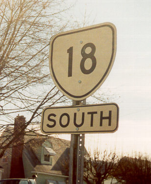
Photo: A scene that was last seen near Rochester, NY in the 70's has been erroneously replicated in Orange (courtesy William Payne)

 
VA 14 From: US 360 St. Stephens Church (King and Queen County)
To: Dead End - Bayside (Mathews County)
Current Length: 69 miles  
ROUTE LOG
US 360: 0 - 0
VA 33 WB: 29 - 29
VA 33 EB: 2 - 31
GL-KQ LINE: 4 - 35
US 17 NB: 1 - 36
US 17 SB, Begin US 17 Bus: 7 - 43
US 17 Bus SB, Begin VA 3: 1 - 44
MT-GL LINE: 7 - 51
VA 3 WB: 1 - 52
VA 198 WB: 7 - 59
VA 198 EB: 2 - 61
END VA 14: 8 - 69

Creation: Appeared in July 1933 as a replacement for part of VA 38 from Bayside to Mathews, all of VA 600 from Mathews to Gloucester, and all of VA 29 from Adner to Bowling Green. This is the 2nd VA 14.
Adjustments: North end was truncated to US 360 between 1954 and 1956. The downgraded section became SR 721.
Posting: Fully posted
Comments: VA 14 is the main road in two of Virginia's most obscure counties: King & Queen and Mathews.  Some maps show VA 14 ending in Bayside, but "Bayside" appears to consist of a muddy cul-de-sac with the ruins of some unidentifiable structure next to a rickety boardwalk leading off into the marsh.  Actually, there is a driveway leading probably to some houses, but this is the most bizarre end of any VA route I've seen so far (not including the 3xx state facilities series, which are rather bizarre to begin with).
A. Froehlig notes that the pavement of VA 14 gets narrower and narrower (VDOT mileage tables have it at 14' total width at its end approach) as you approach its southern end. When you turn right at SR 600 it has no pavement stripes of any kind, and is posted "Road ends 1000 ft"
David Thompson has provided some insight into this mystery:
Bayside was a wharf landing, packing house, etc. of some importance, so it was a logical place to end a state route.  Until August 1933.  The hurricane washed all that away, just leaving the pilings and some other odds and ends laying around.  14 is still signed all the way down there, so I'd be inclined to leave it as the endpoint.

This means VA 14 was up only a month before its end was destroyed.
SR 721 is a much easier drive than the VA 14 section below US 360, which is very twisty.
Previous VA 14's: VA 14 #1: An original state highway. It ran from NC 14 (curr NC 86) below Danville north to Chatham, Gretna, Alta Vista, Evington-Lawyers, Lynchburg, Glasgow, Lexington, Collierstown, Clifton Forge, Covington, and Crows before exiting as WV 3 (curr WV 311).
By 1927, VA 14 was straightened out between Alta Vista and Lynchburg. The old route through Evington-Lawyers became unnumbered (today it is SR's 626, 682, and 683). Also, VA 14 was rerouted between Lexington and Clifton Forge to avoid Collierstown, replacing part of the original VA 172 and leaving behind what I believe was an unnumbered route (curr VA 251 and SR 770). Also in 1927 VA 14 was saddled with all of Virginia's portion of US 170 Danville to Lynchburg, US 60 from Lynchburg to Glasgow, and US 60 again from Lexington to WV. This means VA 14 was taken off these parts in 1929. This left a small piece that ran from Glasgow to Lexington via Buffalo Forge (but not Buena Vista).
In 1930-31, VA 14 was rerouted to go from Glasgow to Buena Vista, then to Lexington, over new construction and replaced a couple miles of VA 13. The old alignment to Lexington went unnumbered (today it is SR 683 and SR 608).
VA 14 met its demise in July 1933 when US 501 was routed this way, and US 60 assumed today's routing east of Lexington.
U.S. 15
VA 15  not currently assigned
Previous VA 15's: VA 15 #1: An original state highway that was in place by 1923. The 1922 Auto Trails Map does not show a VA 15, although there was a road from Ft. Chiswell to Mt. Airy, NC. It began at VA 10 (curr. US 11) in Ft. Chiswell and proceeded SE through Hillsville to NC towards Mt. Airy, where it became then-NC 66. All of this is currently US 52. In 1927 it was paired up in its entirety with US 121. Thus, in 1929, VA 15 was decommissioned.
VA 15 #2: Appeared in 1932 as a newly numbered route. Ran from US 11-121 (curr US 11-52) Ft. Chiswell north to Max Meadows. A short lived route, this VA 15 was renumbered as current VA 121 in July 1933.

 
VA 16 From: NC state line near Mouth of Wilson, Grayson County (continues as NC 16 to Waxhaw, NC)
To: WV state line near Bishop, Tazewell County (continues as WV 16 to St. Mary's WV
Current Length: 84 miles (VA+NC+WV 16 = 462 miles) 
ROUTE LOG
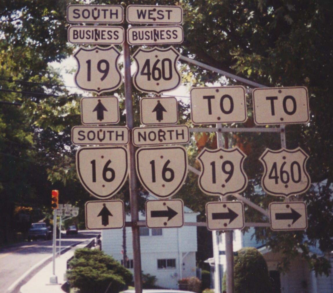
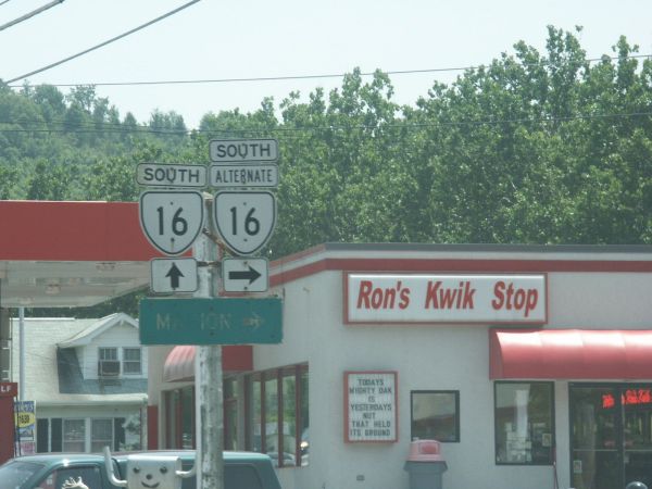
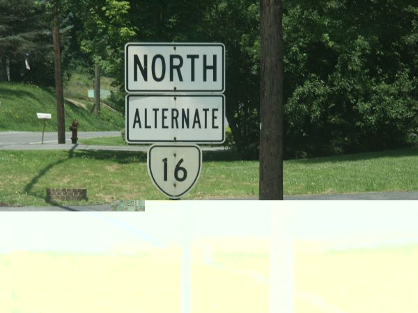
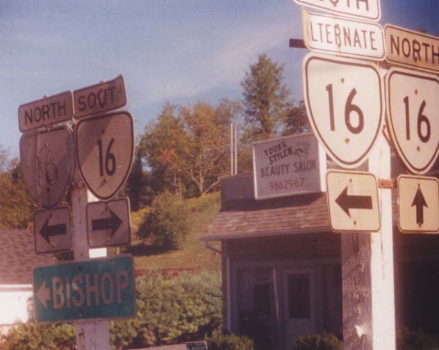
NC STATE LINE: 0 - 0
US 58 EB: 4 - 4
US 58 WB: 4 - 8
SM-GY LINE: 8 - 16
I-81 (exit 45): 17 - 33
VA 217: 0.5 - 33.5
US 11 SB: 1 - 34.5
VA 217: 0.5 - 35
US 11 NB: 1 - 36
VA 348: 5 - 41
VA 42 WB: 11.5 - 52.5
VA 42 EB: 0.5 - 53
TZ-SM LINE: 6 - 59
US 19 Bus SB, US 460 Bus WB: 11 - 70
VA 16 ALT: 1 - 71
US 19 Bus NB, US 460 Bus EB: 1 - 72
US 19, US 460: 1 - 73
VA 61: 0.5 - 73.5
VA 16 ALT: 0.5 - 74
WV STATE LINE: 10 - 84
Creation: Appeared in 1941 as part of the state line renumbering, as the 2nd VA 16. It replaced all of the original VA 88, VA 92, 10 miles of the original US 58 alignment, and the part of original VA 81 north of Tazewell. It was a 2-piece discontinuous route, as there was no road over Brushy Mtn. The southern piece dead-ended 3 miles north of VA 42 and the northern piece at SR 601.
Adjustments: The two sections were connected between 1947 and 1953.
Postings: Fully posted. Many cutouts were present up and down VA 16 as late as 1993, including Marion, and cutouts still exist as of summer 2004 in Tazewell North Tazewell. Error US 16 signs existed in Marion, though I believe they were gone when I passed through in 2000.
Comments: Dave Strong accurately pointed out that one of the delights of doing a page like this is finding a road like Route 16.  What looks like a fairly nondescript route on the VDOT map is actually an epic three-state highway which very nearly goes through 5 states.  It begins in St. Marys, WV near a bridge which Ohio has unfortunately chosen to number OH 807.  From there it goes to the bottom of West Virginia, nipping the western part of Virginia, before entering North Carolina.  It heads down through Charlotte before ending a couple miles from the SC line. Pretty cool.   As late as 1939, none of the 3 states had this road numbered 16 at the state lines (WV 12, VA 81, VA 92, NC 681), so some coordination took place to get this thing numbered as one route.  One thought that occurred to me is that MSR 16 would be a natural extension for US 521, not that I really want 3-state 16 to disappear...
Previous VA 16's: VA 16 #1: An original state highway. Its 1922 routing began at VA 2 (curr. US 15) in Madison Mills, ran to Madison, Syria, then Stanley and ended at VA 21 (curr US 211 Bus) Luray. Thus, original VA 16 crossed the mountain and avoided Sperryville.
In 1923, VA 16 was rerouted north of Madison to end at VA 37(curr. US 522) in Woodville. The old crossing of the mountain went unnumbered for a while, but was the 1933 version of VA 231. Today it is SR 670, a trail over the mountain, SR 689, and US 340 Bus.
By 1927, VA 16 was rerouted to end at Sperryville. The piece to Woodville went unnumbered but eventually became VA 723 and VA 246. Today it is SR 618.
In July 1933 it became a 5-piece discontinuous route: 1. the Madison Mills to Sperryville piece 2. North Anna River to Ferncliff, replacing a piece of the original VA 46 (today this is last western piece of VA 208 plus SR 669) 3. from 8 miles North of Columbia to 2 miles south of VA 6 Columbia (curr SR's 605 and SR 690) 4. a short stub off VA 45 below Cartersville (also curr SR 690) 5. US 60 near Powhatan west to the Cumberland County Line replacing another part of VA 46 (curr SR 684). Pieces 2-5 all replaced pieces of original VA 46.
By 1937, pieces 3-5 became continuous.
When 16 was needed in Southwestern Virginia during the state line renumbering of 1940-41, all 3 pieces of VA 16 were renumbered as the 2nd VA 27.

 
VA 16 ALT From: US 19/460 Bus & VA 16 Tazewell (Tazewell County)
To: VA 16 River Jack (Tazewell County)
Current Length: 2 miles  
ROUTE LOG
US 19 Bus, US 460 Bus, VA 16: 0 - 0
US 19, US 460: 1 - 1
VA 16: 1 - 2
Creation: Appears to be in place by 1956. Explicitly shown and numbered on the Jan 1961 Tazewell County Map. This was unnumbered previously
Adjustments: None
Posting: Fully posted; Cutouts exist in Tazewell and North Tazewell.
Comment: Runs on Fairground Rd. just west of VA 16, as a bypass around central Tazewell. As of October 2003 there is an early 1920's bridge still in use at its northern end.
U.S. 17
VA 17  not currently assigned
Previous VA 17's: VA 17 #1: An original state highway. In 1922 it ran from VA 13-14 (curr US 60) Covington to Warm Springs, Bath Alum, West Augusta, Bridgewater, Harrisonburg, then east to Elkton, Standardsville, finally ending at VA 2 (curr US 15) Gordonsville.
In 1923, VA 17 was rerouted from Warm Springs to go to Goshen, Craigville, Churchville to Bridgewater. The old routing here went largely unnumbered save for a little of original VA 39. Today this is SR 629, US 250, and SR 728.
By 1927, VA 17 was extended from Covington to Clifton Forge, then south to US 11 in Troutville. From Clifton Forge to Eagle Rock this replaced original VA 142. The rest was new routing.
In July 1933, VA 17 was decommissioned to: VA 12 #2 from Troutville to Clifton Forge (curr SR 670 and US 220), VA 18 from Covington to Clifton Forge (curr US 220), VA 501 #3 from Warm Springs to Goshen (curr VA 39), current VA 42 from Goshen to Harrisonburg, VA 4 from Harrisonburg to Gordonsville (curr US 33).
 
 
VA 17 #2: This appeared in July 1933 as an extension to US 17. It originally went from US 1 in Falmouth to US 15/29 in Opal, replacing the western segment of original VA 38. In 1941, to accomodate MD 17, this VA 17 was extended along US 15 to The Plains (using curr. US 17 and VA 245). A discontinuous piece was extended from MD 17 at Brunswick, MD down to Purcellville, plus a stub 1 mile south of there. Today this is VA 287 and SR 690.
Between 1945-47 VA 17 was made into the same alignment as current US 17 all the way to Winchester. The northern piece to Md. became VA 287. The section from Old Tavern to The Plains became today's VA 245. VA 17 was upgraded to US 17 in 1965.

 
VA 18 From: VA 311 Paint Bank, Craig County
To: US 60/220, City of Covington
Current Length: 27 miles  
ROUTE LOG
VA 311: 0 - 0
AG-CG LINE: 5 - 5
COV-AG LINE: 20 - 25
US 60, US 220: 2 - 27
Creation: Appeared in July 1933 in the Great Renumbering II, replacing all of VA 800. It went from then-WV 28 north of Monterrey south through Covington and Potts Creek to end at the Craig County Line. This is the 2nd VA 18.
Adjustments: VA 18 north was truncated to Covington around 1935 when US 220 was extended into Virginia. By 1937 VA 18 south was extended to VA 311.
Posting: Fully posted. Cutouts still existed in Covington (thanks to Gribblenation!) when I drove this in July 2001. US 18 error signs appear on US 60/220.
Comment: This is a very scenic drive through the Potts Creek Valley
Previous VA 18's: VA 18 #1: An original state highway. Began at then-NC 13 south of South Boston and proceeded to Halifax, Brookneal (but NOT Volens - went through Nathalie instead), Lynchburg, Amherst, Lovingston, to VA 9 (curr SR 750) Afton. Today this is SR 707-704, VA 129, SR 626-603, then no current road (VA 18 followed the railroad), US 501, US 29 and VA 6.
In 1927, US 501 was attached to everything south of Halifax. Additionally, VA 18 was given a more direct route between Halifax and Brookneal (today's US 501)
In 1929, VA 18 south was truncated to Halifax. Also, VA 18 was given a less direct, but fully paved route between Amherst and Lovingston - Amherst to Clifford, Roseland, Colleen, then Lovingston. Today this is roughly US 29-VA 151-SR 655-US 29. The section from Amherst to Colleen became VA 312. Today it is SR 739 and US 29.
In 1932, US 29 was added to Virginia and this eliminated VA 18 from Lynchburg to Woods Mill. This made VA 18 a 2-piece discontinuous route. VA 18 was totally eliminated in the Great Renumbering II - the north piece became VA 6 and the south piece became the extended US 501 and VA 129.
U.S. 19
VA 19  not currently assigned
Previous VA 19's: VA 19: an original state highway. Began at VA 2 (curr. US 15) in Dixie and proceeded east to Richmond. In 1929 VA 19 was extended west to VA 28 (curr. US 29) at Covesville. VA 19 was renumbered in its entirety to VA 6 in 1933, and generally remains that way today. Note that current VA 310 is actually part of the original VA 19, as is River Road in Richmond.
VA 19Y: Created in December 1930 (CTB minutes) as a spur from VA 19 (curr VA 6) towards Schuyler. This was renumbered as VA 6Y in July 1933. Today it is SR 800.

 
VA 20 From: US 15 Dillwyn, Buckingham County
To: VA 3 Wilderness, Orange County
Current Length: 95 miles
Business route: Orange (unsure - 20 ALT existed at least 1958-67) 
ROUTE LOG
US 15: 0 - 0
AL-BK LINE: 20 - 20
VA 6 EB: 0.5 - 20.5
VA 6 WB: 0.5 - 21
VA 53: 18 - 39
VA 388: 0.5 - 39.5
VA 317: 0.5 - 40
I-64 (exit 121): 0.5 - 40.5
CHR-AL LINE: 0.5 - 41
US 250 Bus WB: 1 - 42
US 250 WB, US 250 Bus END: 1 - 43
AL-CHR LINE: 0 - 43
US 250 EB: 0.5 - 43.5
OR-AL LINE: 13 - 56.5
US 33 EB: 2 - 58.5
US 33 WB: 0.5 - 59
VA 231: 6 - 65
VA 20 Bus: 6 - 71
US 15 NB: 0.5 - 71.5
US 15 SB: 3 blocks - 71.5
VA 20 Bus: 0.5 - 72
US 522: 10 - 82
VA 3: 13 - 95
Creation: Appeared in July 1933 as a 2 piece discontinuous route - 1. US 15 Dillwyn to VA 6 Scottsville, replacing all of VA 316 2. VA 231 Somerset to VA 3 Wilderness, replacing all of VA 702 and new routing Somerset to Orange. This is the 2nd VA 20.
Adjustments: By 1937 VA 20 piece two was extended west to US 33 Barboursville over a previously unnumbered road. Between 1939-41, VA 20 piece one was extended 6 miles north of Scottsville along current SR 795.
Between 1942-44, this was extended all the way along current SR 795 to Charlottesville (thus eliminating the original VA 239).
Between 1948-53 the 2 sections were connected by overruning SR 615 between Charlottesville and Barboursville. VA 20 was also shifted to its current route between Charlottesville and Scottsville, leaving behind a part of VA 53 and SR 795. This routing had been SR 613.
Posting: Fully Posted. There are cutouts (thanks Gribblenation) up in Orange still at US 15-VA 20 Bus jct and at VA 20-VA 20 Bus west of downtown. Error US 20 signs appear in Orange (pic at top of page), and just west of Montpelier.
Comment: I'd recommend this as a scenic back road between Orange and Charlottesville.
Previous VA 20's: VA 20 #1: An original state highway. The 1922 Auto Trails Map shows VA 20 beginning at VA 18 (curr. US 501) in Brookneal and went to Keysville, Lunenburg, Victoria, Kenbridge, Blackstone, then west to Crewe, Burkeville, then east to Amelia, ending in Richmond (a road did exist from Keysville to Burkeville, but was not numbered).
In 1923, VA 20 was assigned to that direct routing from Keysville to Burkeville, leaving behind VA 323 (curr VA 40) and part of VA 10 (curr US 460)
In 1927 US 501 tagged along from Keysville to Burkeville and US 60 from there to Richmond. VA 20 was extended west over unnumbered routes to US 311 (curr US 220 Bus) Rocky Mount, with a discontinuous section in Pittsylvania County.
In 1929 VA 20 east was truncated to Keysville by these US Hwy sections (curr US 360). VA 20 also was extended west from Rocky Mount to Patrick County, just past Endicott.
In 1930-31, VA 20 became continuous, and was extended west to a couple miles short of VA 23 (curr. VA 8) in Woolwine. All westward extensions were over previously unnumbered roads.
For no apparent reason, VA 20 was renumbered to VA 40 in July 1933.
VA 20 ALT: Was the number for current VA 20 Business in Orange. It existed from March 1956 to at least 1967, before being changed to the business designation
U.S. 21
VA 21  not currently assigned
Previous VA 21's: VA 21: An original state highway. In 1922 ran from VA 3 (curr. US 11) New Market to Luray, Sperryville, Washington, Warrenton, New Baltimore, Manassas, Fairfax, Arlington, and Washington DC.
In 1923, VA 21 was rerouted from New Baltimore-Manassas-Centreville to New Baltimore-Gainesville-Centreville. The Manassas routing became VA 211 (curr VA 215 and part of VA 28).
In 1927, US 211 was paired with VA 21 in its entirety, and thus VA 21 came to a permanent end in 1929. Today it is US 211 and US 29 north of Warrenton.

 
VA 22 From: US 250 Shadwell, Albermarle County
To: US 522 & VA 208 EB Mineral, Louisa County
Current Length: 30 miles  
ROUTE LOG
US 250: 0 - 0
VA 231: 5 - 5
LO-AL LINE: 4 - 9
US 15: 4 - 13
US 33 WB: 6 - 19
VA 208 WB: 5 - 24
US 33 EB: 1 - 25
US 522, VA 208 EB: 5 - 30
Creation: Appeared in 1933 as the 2nd VA 22, from VA 5 (curr. US 250) Shadwell to US 15 & VA 4 Boswells Tavern. All of this had been a small part of original VA 39.
Adjustments: It was extended east to its current end between 1945-47, replacing the original alignment of US 33.
Posting: Fully Posted. Cutouts exist on VA 231 at Cismont (thanks Gribblenation!)
Comments: VA 22 west of Louisa runs through some very scenic horse country. VA 22 could be dropped from US 33 to Mineral, as VA 208 has been multiplexed over it (and beyond in both directions since 1974).
VA 22 is blown off by I-64 but has a 4-lane right-of-way at its underpass.
Previous VA 22's: VA 22 #1: An original state highway in place by 1922. It began at VA 10 (curr. US 11) in Salem and proceeded north to WV near Paint Bank. Currently this is VA 311.
In 1928-29, VA 22 was "extended" north to US 60 (curr. VA 159) at Crows, replacing original VA 143 (where today's 311 goes back through Va. before reaching I-64.) The WV piece in between was WV 81.
In 1930-31, VA 22 was extended south to US 311 (curr. US 220) south of Roanoke.
VA 22 was eliminated in July 1933. Everything north of Salem became the VA 311 US route extension, and the piece below Salem became VA 119. .
U.S. 23
VA 23  not currently assigned
Previous VA 23's: VA 23: An original state highway in place by 1922. It originally ran from VA 12 (curr US 58) Stuart and continued north through Blacksburg and into West Virginia towards Bluefield (as WV 24).
VA 23 was extended south to the NC state line below Stuart (as NC 661) by 1927. This lasted until 1933, when the entire route was renumbered VA 8. Today this is all of VA 8, VA 100 between VA 61 and Pearisburg, and US 460.

 
VA 24 From: VA 116 Roanoke
To: US 60 Mt. Rush
Current Length: 94 miles  
ROUTE LOG
US 220 Bus, US 221, VA 116: 0 - 0
I-581, US 220: 0.5 - 0.5
RO-ROA LINE: 1.5 - 2
Blue Ridge Pkwy: 3 - 5
BD-RO LINE: 1 - 6
VA 122: 17 - 23
VA 43 NB: 6 - 29
VA 43 SB: 3 - 32
CB-BD LINE: 7 - 39
US 29: 10 - 49
US 501 SB: 4 - 53
US 501 NB: 1 - 54
AP-CB LINE: 10 - 64
US 460 WB: 1 - 65
US 460 Bus, VA 26: 8 - 73
US 460 EB, VA 131: 1 - 74
BK-AP LINE: 11 - 85
US 60: 9 - 94
Creation: Appeared in July 1933 as the 2nd VA 24. It had the same general routing of today but also continued west along current US 460 to US 11 in Salem. It replaced all of original VA 207, half of original VA 43, all of original VA 308, and half of original VA 306. There was a large gap from 6 miles east of Stewartsville to the Bedford-Campbell County Line.
Adjustments: By July 1936, VA 24 was continous in the VA 122 vicinity, but had a 2-mile multiplex with VA 122, as VA 24 was using SR 801. Today's routing in this area was established between 1942-44. VA 24 was truncated to its current end in Roanoke when US 460 was extended west around 1946. In 1999 VA 24 was moved onto the US 460 Appomattox Bypass, and the old route became an extended VA 131.
Posting: Fully posted, though not well at Roanoke. Cutout sign was still up in Vinton May 2001, verified May 2005 - I took a picture but it turned out very bad. Roanoke embossed cutout was up as late as 1991
Comment: Passes Appomattox Court House National Historic Park. VA 24 would be an excellent alternative for US 460 from Appomattox to Roanoke if it weren't for the stretch between Evington and current VA 43, which is very gnarly. When I drove this I passed a pickup truck lodged in a tree where it didn't make the turn....
Previous VA 24's: VA 24 #1: An original state route. Ran from VA 12 (curr US 58 Bus) Emporia southwest through Brink to NC. This scan of the 1922 Rand McNally shows the earliest alignment
In 1923, VA 24 was rerouted to go directly south to then-NC 40 via Skippers. This was mostly new routing, and shared just the northernmost 1/2 mile with the original VA 24 (Main St. in Emporia). The old VA 24 route to NC went unnumbered after that, and today is SR 627.
By 1927, VA 24 was extended to Petersburg over new routing to VA 35, and it replaced VA 35 for 10 miles to Petersburg. It attracted the attention of US 17-1 in 1927, who moved in and took over for good by 1929. Today this original VA 24 is part of US 301.
VA 24 #1
U.S. 25E
VA 25  not currently assigned
Previous VA 25's: VA 25: An original state highway in place by 1922. It ran from Manassas along with VA 21 to Fairfax and Vienna to Washington DC at the Chain Bridge.
In 1923, VA 25 west was truncated to VA 21-36 (curr. US 29-50) in Fairfax, leaving behind part of VA 211 (curr VA 28).
By 1927, VA 25 was extended east via Arlington to VA 31 (curr. US 1) near Alexandria. Today this would be VA 123, VA 120, and South Glebe Road.
VA 25 (1928)
In 1929 it was extended from Fairfax to Occoquan to meet US 1. This is also current VA 123. VA 25 was renumbered in its entirety as original VA 9 during the 1933 Great Renumbering II.

Last Update: 25 June 2005

Previous: VA 8 - 13  |  Next: VA 26 - 37
Top  |  Virginia Hwy Index Home