
< 1 to 7 | Home | 14 to 25 > Photo: |
|||||||||||||||||||||||||||||||||||||||||||||||||||||||||||||||||||||||||||||||||||||||||||||||||||||||||||
|
|
|
| ROUTE LOG |
US 11: 0 - 0 I-81 (exit 114): 1 - 1 FL-MO LINE: 9 - 10 US 221: 8 - 18 Blue Ridge Pkwy: 6 - 24 PT-FL LINE: 0 - 24 VA 40: 6 - 30 VA 57: 6 - 36 US 58 WB: 4 - 40 US 58 EB: 4 - 44 VA 103: 4 - 48 NC STATE LINE: 5 - 53
|
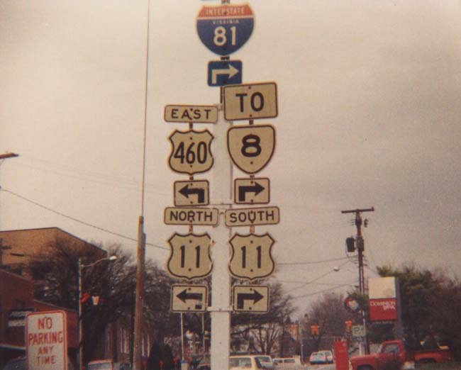
Creation: Appeared in 1933 as a straight renumbering of VA 23, which included all of today's VA 8 plus US 460 west to the WV line heading for Bluefield. This is the 2nd VA 8.
| Adjustments: Truncated to Rich Creek when US 219 was introduced into Virginia in 1938; truncated to its current route around 1946 when US 460 was extended over it. The '44 Official map shows VA 8 and VA 100 swapping locations in the Pearisburg-Narrows area, but I think it is an error (it also showed VA 100 and VA 101 switched around). Posting: Fully posted. Cutouts exist in Christiansburg, although this particular 1991 Gribblenation photo location has been replaced, I believe. Comments: None. | Previous VA 8's: | VA 8 #1: An original state route until 1923. Ran from VA 1-7 (curr US 1 Bus, VA 3 Bus) Fredericksburg to Corbin, Port Royal, Tappahannock, Saluda, Cobbs Creek, ending at Matthews. In 1923, VA 8 was renumbered as part of VA 38. Today this would be VA 2, SR 610, Fort AP Hill Roads, US 17, VA 33, VA 3, VA 198, and VA 14. | ||||||
|
|
|
| ROUTE LOG |
VA 7, VA 7 Bus: 0 - 0 VA 287: 6 - 6 WV STATE LINE: 7 - 13
|
Creation: Appeared in 1940-41 to match WV 9. Replaced VA 238 in its entirety. This is the 3rd VA 9.
| Adjustments: None Posting: Fully posted Comments: This road is under scrutiny because it has become a major commuting route from Chares Town, WV to Northern Virginia. WV intends to widen its half, but VDOT does not seem interested in following suit. Incidentally Maryland should change MD 51 to MD 9, since they don't have one. | Previous VA 9's: |
VA 9 #1: An original state route until 1923. Ran from West Virginia west of Highland, to Staunton, Waynesboro, Charlottesville, Louisa, Mineral, Montpelier, Negro Foot, Elmont, to Richmond, then east to New Kent, Williamsburg, Lee Hall, Newport News, ending in Hampton. In 1923, VA 9 west of Highland became unnumbered (though a little later VA 395), Highland to Richmond became VA 39, Richmond to Williamsburg via New Kent became VA 393 (VA 39 was given to US 60's routing), and Williamsburg to Hampton became VA 39. To do VA 9's route today, it would be: US 250, VA 240, US 250, VA 22, US 522, US 33, VA 54, SR 626, Old Washington HWY, Purcell Rd, US 33, US 60, VA 249, VA 30-33, VA 273, VA 30, US 60, VA 143.
VA 9 SPUR #1: Shown on 1922-23 Auto Trails Map (sans "Spur" or "A", just as "9"). Ran from VA 9 (curr VA 5-132) to Jamestown. This became VA 392 in 1923. VA 9 SPUR #2: just like SPUR #1 above, but ran from VA 9 (curr US 60) Lee Hall to Yorktown, Gloucester, then over to West Point. The 1922-23 map shows a bridge over the York River. In 1923 this spur became VA 391 from Lee Hall to Yorktown, VA 29 from Gloucester Pt. to Shacklefords, and VA 30 from there to West Point. Today this is VA 238, US 17, VA 14, and VA 33. VA 9 #2:Created in 1933, it replaced in its entirety the only VA 25, which at that time was all of current VA 120 and most of 123 - a large semi-circle from US 1 in Woodbridge to US 1 in Alexandria (it followed today's East Glebe Road). In 1938 it was routed onto South Glebe Road. It was replaced by 120 and 123 when the number 9 was needed at the WV border. VA 9X: Described as thus in November 1922 CTB minutes: "from West Point to Richmond either via New Kent C.H. or King William C.H. through New Kent and Henrico Counties or through King William County." Later in 1923, the New Kent option became VA 393 (VA 30-33 and VA 249 today) and the King William option became VA 30. |
||||||
|
|
|
| ROUTE LOG |
US 360: 0 - 0 VA 161 NB: 0.5 - 0.5 VA 161 SB: 0.5 - 1 CH-RIC LINE: 2 - 3 VA 150: 2 - 5 VA 288: 5 - 10 VA 145: 2 - 12 VA 144 SB: 4 - 16 VA 144 NB: 0.5 - 16.5 US 1, US 301: 2 - 18.5 I-95 (exit 61): 0.5 - 19 I-295 (exit 15): 4 - 23 HOP-CH LINE: 3 - 26 VA 36: 0.5 - 26.5 VA 156 Bus SB: 0.5 - 27 PG-HOP LINE: 1 - 28 VA 106 SB, VA 156 SB, END VA 156 Bus: 1 - 29 VA 106 NB, VA 156 NB: 1 - 30 SU-PG LINE: 13 - 43 VA 40: 6 - 49 VA 31 SB: 8 - 57 VA 31 NB: 1 - 58 IW-SU LINE: 7 - 65 VA 10 Bus: 5 - 70 US 258 SB, US 258 Bus: 2 - 72 US 258 Bus, VA 10 Bus: 2 - 74 US 258 NB, VA 32 NB: 2 - 76 SUF-IW LINE: 4 - 80 VA 125: 1 - 81 US 13, US 58, US 460, VA 32 SB, Begin VA 32 Bus: 6 - 87 US 460 Bus WB: 1 - 88 US 13 Bus NB, US 58 Bus, US 460 Bus: 1 - 89 US 13 Bus SB, VA 32 Bus SB, VA 337: 0.5 - 89.5
|
Creation:VA 10 is an original state highway. It's 1922 routing: originally ran from Cumberland Gap to the Virginia Beach Oceanfront, via Bristol, Roanoke, Lynchburg, Farmville, Petersburg, Smithfield, and Suffolk. This was ~550 miles. It followed today's routes like so: US 58 from Cumberland Gap to Jonesville, US 58A from there to Pennington Gap, US 421 from there to Pattonsville, SR 638-600 to Clinchport, US 421 from there to Bristol, US 11 from there to Wytheville(used todays SR 609 from Abingdon to Glade Spring), SR 610 from there to Pulaski, US 11 to Roanoke, US 221 from there to Lynchburg, US 460 from there to Petersburg, VA 106-SR 609 from there to Garysburg, VA 10 from there to Suffolk, VA 337 from Suffolk to Norfolk, and US 58 out to the beach. So about half of today's VA 10 was also VA 10 in 1922.
| Adjustments: 1920's system. In the 20's, VA 10 was rerouted between Wytheville and Pulaski to go through Draper, utilizing today's F-044 (old US 11), old VA 100, and VA 99. VA 10 received some US Hwy designations in 1927: US 411 From Cumberland Gap to Bristol, US 11 from there to Roanoke; US 60 from Lynchburg to Burkeville; and US 117 from Suffolk to Va. Beach. VA 10 remained solo from Roanoke to Lynchburg and Burkeville to Suffolk. 1929 Great Renumbering: When VA 10 was removed from US Hwys, this created 2 discontinuous sections, from Roanoke to Lynchburg, and from Burkeville to Suffolk. In 1932, the piece from Suffolk to Portsmouth along current VA 337 was re-established, as US 117 was decommissioned, and US 58 used the new (current) direct route. 1933 Great Renumbering II: VA 10 went back to being a one-piece route in July 1933, from VA 36 Petersburg to US 58-460 (curr VA 337) Suffolk. The rest of it became US 460. In 1935 though, VA 10 was extended from Suffolk over what was VA 52 to NC, where it became NC 32; also the west end shifted to its current alignment, replacing what was VA 37 #3. The Garysburg to Petersburg section became VA 37 #4. 1940-41 Minor Renumbering: VA 10 eastbound was cutback to Benns Church, to make room for VA 32 to match NC 32. VA 10 was restored to its current route by 1947. Posting: Fully posted; Richmond cutout at US 360 removed late 2001 I believe; Hopewell cutout was still up in 2001 (gone by spring 2005); Surry had a cutout as late as 1993 (gone by spring 2005). Check out this 1973 cutout assembly in Suffolk. In June 2005, A. Froehlig points out that VA 10 signs south of the US 13-58-460 Bypass are sparse, although at the jct with Main St and Washington St there are VA 10 shields on small green signs. Comments: Sort of meanders from its endpoints now. Most wouldn't use it. | Previous VA 10's: | VA 10Y: Mentioned in CTB minutes October 1922. It ran from VA 10 (curr US 11) Abingdon over to Hansonville, then ending at VA 11 (curr VA 71) Dickensonville. In 1923 this was renumbered as the first VA 106. Today it is part of US 58A. | ||||||
| U.S. 11 |
| VA 11 not currently assigned | |||||||||||||||
| Previous VA 11's: |
VA 11: An original state highway. It started out at the KY state line at Cumberland Gap, running along with VA 10 to Woodway, then proceeded solo through Norton, Coeburn, Lebanon, Tazewell, and ran into WV at Bluefield. This is approximated in order by today's US 58, SR 642, US 58A, VA 74, US 58A, VA 158, US 58A, VA 71, and US 19.
In 1923, VA 11 west was truncated to VA 10 (curr US 421) Woodway, with VA 10 remaining west to Cumberland Gap. From Lebanon eastward US 19 appeared as VA 11's roommate around 1928. In 1929, VA 11 north was truncated to Lebanon. VA 11 was retired for good in 1933 and was replaced in its entirety by the original VA 64 (which also ran further SW into Tennessee). VA 11A: Mentioned in December 1930 CTB minutes as running between Tazewell and Five Oaks. This was either today's US 19-460 Bus or SR 678. Presumably mainline VA 11 used the other. VA 11Y: Appeared in July 1933 in Staunton, as a replacement for mainline US 11 through downtown. By 1937, US 11 was re-installed over VA 11Y. Today VA 11Y is US 11 Bus. VA 11Z: Shown on 1922-23 Auto Trails Map, running from VA 11 (curr VA 158) Coeburn north to Clintwood, then east to end in Grundy. In 1923, Coeburn to Clintwood became the first VA 114, and Clintwood to Grundy became VA 1141. Today this is part of VA 72, VA 83, and VA 63. VA 11Z explicitly appears in the October 1922 CTB Minutes. |
||||||||||||||
| VA 12 not currently assigned | |||||||||||||||
| Previous VA 12's: |
The lowest number in Virginia not currently being used is 12. There have been 3 previous VA 12's:
VA 12 #1:The 1920's system An original state highway. It began at VA 10 (curr US 11) in Meadowview and ran continuously to end at VA 10 (curr VA 10/32) in Suffolk, via Independence, Hillsville, Stuart, Martinsville, Danville, Halifax, Boydton, South Hill, Clover, Chase City, Emporia, and Franklin. This is approximated by today's SR 803, SR 731, no current road to Konnarock, US 58 to Danville, all of VA 360, US 360 to VA 92 to Boydton, US 58 to Virginia Beach. In 1923, VA 12 east was truncated to VA 10 Suffolk, leaving behind VA 10. In 1928 or 1929, VA 12 was rerouted west of Mouth of Wilson to follow: VA 16 north, SR 650 and 762 west, VA 91 south to Damascus, and US 58 to end at US 11 Scotts Addition 1929 Great Renumbering. VA 12 was extended east to US 60 in Virginia Beach (near today's US 13/60 JCT) and sections of VA 12 were eliminated where US Hwys had come along. This made VA 12 into a 4-section discontinuous route: 1. Abingdon to Halifax, where early US 501 intervened. 2. Wyliesburg to Boydton, where defunct US 401 took over. 3.South Hill to Franklin, where it was cutoff by retired US 117. 4. Suffolk to Va. Beach - this new section was mostly new construction, but maybe replaced the last couple miles of original VA 101. In 1932, section 1 was reduced to Abingdon to Independence, as US 221 was extended north into VA, and US 58 appeared from east of Hillsville to Danville. Section 4 was also reduced to run only from Norfolk to US 60, as US 58 took over from Suffolk. A 5th VA 12 segment appeared from US 58-60 Jct south to Camp Pendleton, replacing VA 501. All sections of VA 12 were eliminated in the 1933 Great Renumbering II, becoming US 58 (curr US 58-VA 91, SR 762, SR 650, VA 16, US 58) from Abingdon to Independence, US 360 (curr VA 360) from Danville to Halifax, VA 46 (curr VA 92) from Wyliesburg to Boydton, US 460 (curr US 13) in the Little Creek Area, and US 60 in the Camp Pendleton Area. VA 12 #2: VDOT quickly recycled the number 12 in July 1933. It ran from US 11 Troutville to US 60 Clifton Forge, replacing what had been a part of the original VA 17. This route lasted until only about 1935, when it was overrun mostly by US 220 and all of VA 294 (US 220 was sent directly from Fincastle to Daleville). VA 12 #3: VDOT again ran this number back out in the field in a hurry, by 1937. This VA 12 started out as a 2-piece discontinuous route: 1. US 11 near Greenville to VA 3 (curr US 522) in Front Royal, and followed today's US 340 for all of that except between Grottoes and Elkton where it used today's SR's 825,659,672, and US 33. 2. Rockland to Berryville (today's SR 658 to White Post and US 340 to Berryville). Both of these sections were previously VA 340. In 1938 these two sections were connected, using todays SR's 661,624,and 647. Between 1942-44, VA 12 began using the current US 340 alignment from Grottoes to Elkton, and using the current US 340 alignment from Front Royal to Berryville. The old sections were downgraded to the SR's above. VA 12 #3 was replaced in its entirety by a very extended US 340 between 1954-56. VA 12X #1: Appeared in September 1922 CTB Minutes as the route from Deep Creek south to N.C. By the end of 1923 this became VA 40. Today it is part of US 17 and US 17 Bus. VA 12X #2: Appeared in October 1922 CTB Minutes as the route from VA 12 (curr US 58) near South Hill south to N.C. Later in 1923 this became the first VA 122. Today it is part of US 1. VA 12Y: Appears in CTB Minutes in January and April 1923 as the designation for the route from Franklin to the NC Line. By the end of 1923 this had become VA 121. Today it is part of US 258. VA 12Z: Appears in November 1922 CTB minutes as the designation for the route between VA 12 (curr US 58-221) Hillsville and the NC Line below Cana. This may have taken a while to be built, as the first reference to VA 15 occurred in April 1924. Today this is part of US 52. |
||||||||||||||
| U.S. 13 |
|
|
|
| ROUTE LOG |
US 60, VA 45: 0 - 0 PO-CU LINE: 8 - 8 VA 300: 13 - 21 US 60: 2 - 23
|
Creation: Appeared around 1935, when US 60 was moved to a new, straighter alignment. This is the 2nd VA 13, although there has been a 3rd VA 13 that came and went while this one was active.
| Adjustments: None. Posting: Fully posted. Comments: This has been a numbering violation since its inception. There is no logical reason to have assigned 13 to this route, unless VDOT was slow to remove 13 signs at the 1933 Great Renumbering II and chose to keep them up, a possibility since the 1933 map said that the old signs would remain up for a period of time. | Previous VA 13's: |
VA 13 #1: An original state highway. The 1922-23 Auto Trails shows VA 13 starting at the WV line (curr VA 311 crossing) as a multiplex with VA 14. It went to Covington, Clifton Forge, Collierstown, Lexington, Natural Bridge, and Lynchburg (all while attached with VA 14). It then hooked up with VA 10 (curr US 460) from Lynchburg to Appomattox to Farmville. Finally VA 13 was alone as it progressed east to Cumberland, Powhatan, and Richmond and ended at VA 8 (curr US 17) Brays Fork.
In 1923, VA 13 west was truncated to VA 10-32 (curr US 15 Bus, US 460 Bus) Farmville, leaving behind its former mates VA 14 and VA 10, except for Lexington-Natural Bridge-Glasgow, which became part of VA 33 and all of the first VA 141. In 1925, VA 13 was extended east through Tappahannock, to end at VA 371 (curr US 360) in Lottsburg. This was not numbered in 1924, but was part of original VA 7 briefly. In 1928, the eastern end was moved to Callao. The western end was extended to the original VA 14 west of Buena Vista (curr US 60-SR 608 jct), over what was mostly unnumbered roads, although it did swallow the original VA 322. There were some gaps in VA 13 in this western extension initially. 
The section from Cumberland to Farmville became the 1st VA 133. Note that this routing went directly through Dillwyn (via SR 629) until 1930-31, unlike the modern version of US 60. This VA 13 was eliminated in 1933 when US 60 was moved to its familiar routing, and US 360 was christened for the section east of Richmond. VA 13 #3: Without changing the VA 13 in place in central Virginia, VDOT created this VA 13 as a US Hwy extension in 1938. It ran from the ferry landing at Little Creek down Diamond Springs Rd to end at US 460 (curr US 13 Northampton Blvd). This was a replacement of a piece of VA 165. By 1941, VA 13 was extended along today's VA 166 through Norfolk and South Norfolk to Military Hwy (curr US 13-460), then west to Bowers Hill where it ended at US 58. It replaced all of the original VA 299, and was cosigned with US 460 and VA 170 for much of its non-Military Hwy alignment. This VA 13 was upgraded to US 13 by 1944 on Diamond Springs Rd. The road into Norfolk became one of the VA 13Y's. South of Norfolk became US 460, and Military Hwy was also US 13. VA 13Y #1: Ran from US 58-460 in Norfolk to US 13 along Princess Anne St. Today this is VA 166. Created between 1942-44. Replaced some of VA 13 and was changed to VA 166 when decommissioned in 1956. VA 13Y #2: Appeared between 1942-44, running from US 13 to US 60 in Virginia Beach, on today's Shell Rd. from Diamond Springs Rd. (was US 13 at the time) to Pleasant House Rd then along that to Shore Dr. Was previously the last part of US 460. VA 13Y was renumbered to VA 166 in 1956. Today, most of VA 13Y #2 is not primary routing, as Shell Rd. was bypassed by Northampton Blvd. in 1964. However, Northampton Blvd.'s bridge of Lake Smith may have been on VA 13Y's alignment. Today's VA 225 altered the track of the Shell Rd. to Pleasant House Rd connection. Pleasant House Rd is known today because it is still posted as SR 651 at US 60, 40 years after SRs were removed from the Tidewater area. For some reason, both VA 13Y's are shown as US 13Y on VDOT official maps from 1952, 1953, and 1954. |
||||||
| VA 13 ALT Decommissioned | |||
| Previous VA 13 ALT's: | VA 13 ALT: Appears in some CTB Minutes in 1931 and 1932 as the proposed new construction between Cumberland and Powhatan. By the time this was completed, US 60 was using the original VA 13, so VA 13 ALT was never actually signed. | ||
Previous: VA 1 - 7 |
Next: VA 14 - 25
Top | Virginia Hwy Index
Home
