
< 151 to 175 | Home | 201 to 225 > | |||||||||||||||||||||||||||||||||||||||||||||||||||||||||||||||||||||||||||||||||||||||||||||||||||||||||||||||||||||||||||||||||||||||||||||||||||||||||||||||||||||||||||||||||||||||||||||||||||||||||||||||||||||||||||||||||||||||||||||||||||||||||||||||||||||||||||||||||||||||||||||||||||||||||||||||||||||||||||||||||||||||||||||||||||||||||||||||||||||||||||||||||||||||||||||
|
|
|
| ROUTE LOG |
VA 316: 0 - 0 US 13: 2 - 2
|
| Creation: Appeared in July 1933 as a renumbering of VA 521. Ran as it does today. This has been the only VA 176. Adjustments: None Posting: Fully Posted Comments: Drove this in August 2003. Parksley is a place with an actual downtown... |
|||||||||
|
|
|
| ROUTE LOG |
I-81 (exit 109): 0 - 0 RAD-MO LINE: 2 - 2 US 11: 2 - 4
|
| Creation: Appeared in 1966, overrunning SR 638. Ran as it does today. This is the 2nd VA 177. Adjustments: None Posting: Fully posted Comment: Spur from I-81 to US 11. Goes right through Radford College. | Previous VA 177's: | VA 177 #1: Appeared in July 1933 as a new route. Ran from US 13 Accomac north to VA 176 Parksley. Between 1942-44, VA 177 north of VA 316 was downgraded to SR 763. The remaining portion of VA 177 was downgraded to SR 764 between 1959-61. | |||||||
|
|
|
| ROUTE LOG |
US 13 Bus: 0 - 0 US 13: 0.5 - 0.5 AC-NO LINE: 0.5 - 1 VA 181: 0.5 - 1.5 VA 180: 8 - 9.5 SR 718: 0.5 - 10
|
Creation: Appeared in July 1933. Started out as a 2 piece route: 1. US 13 Exmore to 5 miles past VA 180 Pungoteague (new route)2. US 13 Tasley to VA 179 Onancock. (replaced VA 522) This has been the only VA 178.
| Adjustments: Piece 2 was extended west to the water between 1939-41. Maps from 1961-66 imply the 2 pieces were connected, but the 1967 map shows SR 718 between them. By 1977 piece 1 was truncated to SR 620, replaced by more SR 718. Piece 2 was renumbered as VA 126 in 1994. Posting: Fully posted Comment: Never driven this one... .. |
|||||||||
|
|
|
| ROUTE LOG |
US 13 Bus: 0 - 0 US 13: 0.5 - 0.5 VA 126: 1 - 1.5 END VA 179: 0.5 - 2
|
Creation: Appeared in July 1933 as a renumbering of VA 540. Ran from VA 178 (curr VA 126-179 jct) Onancock to Locustville (4 miles east of US 13 Onley). This has been the only VA 179.
| Adjustments: VA 179 was downgraded to SR 789 east of US 13 in 1952. In 1993 or 1994, VA 179 was extended west to Onancock's waterfront, replacing some of the northern piece of VA 178. Posting: Fully Posted, except within the town limits of Onancock. Comment: I drove this in August 2003. VA 179 is 4-lanes between VA 126 and US 13. Onancock is a charming town. |
|||||||||
|
|
|
| ROUTE LOG |
BEGIN VA 180: 0 - 0 VA 178: 3 - 3 US 13 SB: 3 - 6 US 13 NB: 1 - 7 VA 180Y: 4 - 11 SR 1701: 2 blocks - 11
|
Creation: Appeared in July 1933 as a renumbering of VA 523. Ran as it does today. This has been the only VA 180.
| Adjustments: None Posting: Fully posted Comments: Zig-zags with US 13 at Keller; VA 180 is quite modern between US 13 and Wachapreague. VA 180 connects two boat harbors. VA 180 is one of just 2 normal state routes on the Eastern Shore with no stoplights (the other is VA 316). |
|||||||||
|
|
|
| ROUTE LOG |
VA 180: 0 - 0 SR 624: 0.55 - 0.55
|
| 180Y does exist - no idea how long it has been there (the 1937 VDOT map implies it is). It is shown explicitly on the 1961 Accomac County Map; In Wachapreague, 180 runs east. At last or next to last street running N-S, 180Y is shown running north to edge of town, then west 1 block. VDOT mileage listed as 0.55. I got to drive this August 2003 -- there is a reassurance shield at its junction with VA 180, but not at its other end at SR 624. Oddly, at most intersections in the town, VA 180Y is shown on white rectangles as just 180. |
|||||||||
|
|
|
| ROUTE LOG |
US 13: 0 - 0 VA 178: 0.75 0 0.75 END VA 181: 0.25 - 1
|
Creation: Appeared in July 1933 as a new route, but had been part of US 13 as late as 1931. Ran at least from US 13 to VA 178. This is the 2nd VA 181.
| Adjustments: The 1961 County Map and 1993 VDOT County Atlas show a stub north of VA 178 to the Belle Haven town line. No idea when this got there. Perhaps the stub was a route and VA 178 was a route that both ended at the right-turning US 13. Posting: Fully Posted at US 13; reassurance shield at north end; per A. Froehlig, not posted at all at VA 178 Comment: VA 178 and VA 181 swap streets within Belle Haven. | Previous VA 181's: | VA 181 #1: Appeared between 1924-28. Ran from VA 18 (curr VA 6) to Nellisford. This was renumbered as VA 315 in 1929. Today it is part of VA 151. | |||||||
|
|
|
| ROUTE LOG |
US 13: 0 - 0 SR 605: 4 - 4
|
Creation: Appeared in July 1933 as a new route. Ran as it does today. This is the 2nd VA 182.
| Adjustments: None Posting: Fully posted, although not that well at its eastern end. A cutout was observed on SR 600 SB in August 2003 and again by A. Froehlig in September 2004 Comment: At least I've driven half of this one. But all I remember is lunch at Formy's BBQ on US 13 in Painter. | Previous VA 182's: | VA 182 #1 Appears in CTB records as a spur from VA 18 (curr VA 151) Claypool towards Lowesville. In Sept. 1927 VA 182 was extended 1.18 more miles towards Lowesville. In 1929, VA 182 became VA 313. Today it is part of SR 778. | |||||||
|
|
|
| ROUTE LOG |
US 13 Bus: 0 - 0 US 13: 0.5 - 0.5 SR 613: 7 - 7.5
|
Creation: Appeared in July 1933 as a new route. Ran further east to Willis Wharf. This has been the only VA 183.
| Adjustments: VA 183 East was truncated to US 13 between 1948-50. The old part became SR 603. Posting: Fully Posted Comment:VA 183 WB continues as SR 613 to Silver Beach. |
|||||||||
|
|
|
| ROUTE LOG |
US 13, US 13 Bus: 0 - 0 END VA 184: 3 - 3
|
Creation: Appeared in 1958 as a renumbering of US 13 ALT. Ran as it does today. This is the 2nd VA 184.
| Adjustments: None Posting: Fully posted Comment: Formerly part of US 13. I have driven this one, VA 184 runs right along the bayfront in Cape Charles. | Previous VA 184's: | VA 184 #1: Appeared in July 1933 as a renumbering of VA 527. It was a spur west of US 13 Nassawadox to Franktown. VA 184 was downgraded to SR 608 between 1954-55. | |||||||
|
|
|
| ROUTE LOG |
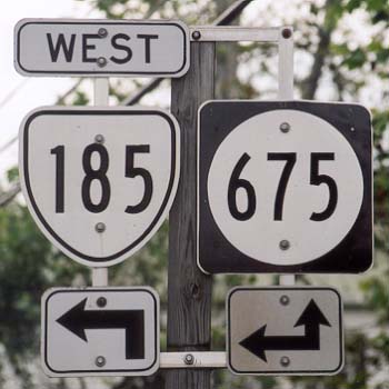
I-81 (exit 279): 0 - 0 US 11: 0.75 - 0.75
|
Creation: Appeared cosigned with SR 675 in 1967. This is the 2nd VA 185.
One of the many I-81 to US 11 connectors.
| History: VA 185 was once a spur east of US 13 at Eastville. Posting: Fully posted. Cutout still up in Edinburg Comment: Yet another I-81 to US 11 connector. | Previous VA 185's: | VA 185 #1: Appeared in July 1933 as a renumbering of VA 524. Was a short stub east off US 13 Eastville to the RR track. This was downgraded to SR 631 in 1953. | |||||||
|
|
|
| ROUTE LOG |
VA 35: 0 - 0 NC STATE LINE: 6 - 6
|
Creation: Appeared in 1974 as a renumbering of VA 195. Ran as it does today. This is the 2nd VA 186.
| Adjustments: None Posting: Fully posted Comment: I used to use this as a short cut to get from Norfolk to I-95 South, along with SR 671 to Franklin (a VA 186 upgrade would be a good idea...) | Previous VA 186's: | VA 186 #1: Appeared in July 1933 as a renumbering of VA 525. Ran from US 13 Bayview to Kiptopeke. In 1951, VA 186 north was truncated to Capeville, with the moving of US 13 to the Kiptopeke Ferry. The remainder of VA 186 was downgraded to SR 684 and SR 600 in 1952. | |||||||
|
|
|
| ROUTE LOG |
SR 658: 0 - 0 VA 316: 2 - 2 US 13: 2 - 4 SR 679 NB: 3 - 7
|
Creation: Appeared in July 1933 as a renumbering of VA 531. Ran as it does today. This has been the only VA 187.
| Adjustments: None Posting: Fully posted, except at its eastern end. The last VA 187 sign EB is at its turn northward on SR 679. There are no shields west of VA 316, either. White rectangle 187 sign is all that is on its western end near Guilford. Comment: Crosses US 13 at Nelsonia. I drove VA 187 in August 2003 - VA 187 is the least modern of the Eastern Shore state routes, with narrow lanes and SR-like alignments. |
|||||||||
|
|
|
| ROUTE LOG |
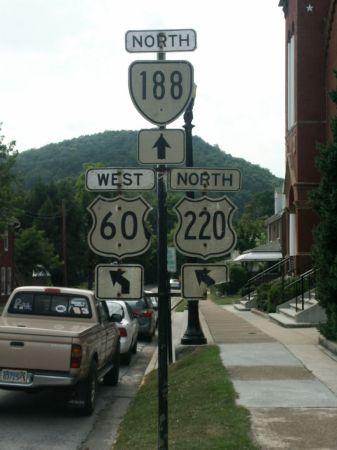
US 60 Bus, US 220 Bus: 0 - 0 SR 606: 1 - 1
|
Creation: Unsure of its creation. Appears on VDOT state maps starting 1994. The cutouts for this route are far older than this. At any rate, it likely ran as it does now. This is the 2nd VA 188.
| Adjustments: None Posting: Fully posted. All signs are really old (early 70's looking) cutouts. No modern signs at all as of June 2001. Very well posted throughout town. Comments: Makes 4 turns in town before ending under the I-64 overpass. Continues on as SR 603. | Previous VA 188's: | VA 188 #1: Appeared in July 1933 as new routing. Was a short spur north of US 60 Toano. Eventually connected to the new VA 168 (curr I-64) and a little further east. VA 188 was downgraded to SR 607 between 1945-47. | |||||||
|
|
|
| ROUTE LOG |
US 258: 0 - 0 SUF-SO LINE: 2 - 2 VA 272: 1 - 3 US 58 WB, US 258: 1 - 4 VA 272: 3 - 7 US 58 EB: 8 - 15 US 58 Bus: 0.5 - 15.5
|
Creation: Appeared in July 1933 as a renumbering of VA 535. Ran from US 58 Franklin to US 58 Holland. This has been the only VA 189.
| Adjustments: Between 1942-44, VA 189 was rerouted at South Quay to go to US 258 instead of Franklin. This eliminated VA 315 #3. The piece to Franklin became SR 714. In 1988, VA 189 was rerouted where it meets US 58 Bypass. A new road was built to meet the US 58-US 258 (old VA 260) jct, and VA 189 was put on it. The old alignment to US 58 became VA 272. Posting: Fully posted; In 1992-93, the piece in the town of Holland was erroneously posted as VA 189 Bus. Comments: Not much exciting about VA 189. An odd route: spurs off of US 58 Bus. in Holland, then concurrent with US 58 for about 10 miles, before branching off toward US 258 for 4 miles. |
|||||||||
|
|
|
| ROUTE LOG |
VA 166: 0 - 0 I-64 (exit 292), US 17: 1 - 1 US 17: 0.5 - 1.5 VA 168 Bus: 2.5 - 4 VAB-CHE LINE: 3 - 7 VA 165: 4.5 - 11.5 I-264 (exit 16): 1 - 12.5 US 58: 0.5 - 13 VA 225: 2 - 15
|
Creation: Appeared in 1956. Ran from VA 166 to VA 165 Kempsville. All of this had been part of VA 166. This is the 2nd VA 190.
| Adjustments: In 1982, VA 190 north was extended to VA 225. Posting: Fully posted. Numerous 190 signs in cirles exist in Virginia Beach, although a couple shields do occur. VA 190 was never identified from VA 44 - Virginia Beach Expwy. A. Froelig reports that the I-264 change did not change that. Comments:Includes Witch Duck Rd., one of my favorite road names. | Previous VA 190's: | VA 190 #1: Appeared in July 1933 as a renumbering of VA 536. Ran from VA 165 North Landing south to Blackwater, ending at the Pungo Ferry. Between 1939-41, VA 190 was extended over the ferry to SR 615. VA 190 was downgraded to SR 726 between 1948-56. Today it is Blackwater Rd. and Pungo Ferry Rd. As late as 1993 there were 615/726 signs at that intersection. | |||||||
|
|
|
| ROUTE LOG |
US 13, US 58, US 460, US 460 ALT: 0 - 0 VA 337: 2 - 2
|
Creation: Appeared in July 1933 as a renumbering of VA 539. Ran as it does today. This is the 2nd VA 191.
| Adjustments: None Posting: Fully posted Comments: VA 191 is Joliff Rd., which today is not much more than a glorified frontage road for I-664. Gets mentioned from I-664 NB though. | Previous VA 191's: | VA 191 #1: Appears on the 1928 VDOT map. Ran from VA 19 (curr VA 6) Goochland south to Jefferson. In 1929 this was renumbered as VA 417. Today this is part of US 522. |  VA 191 in 1928. |
||||||
|
|
|
| ROUTE LOG |
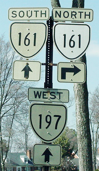
VA 165: 0 - 0 VA 170: 2 - 2
|
Creation: Appeared as a new numbered route in 1953. Ran as it does today. This is the 3rd VA 192.
| Adjustments: None Posting: Fully posted as late as 1993. A. Froehlig reports that there are no VA 192 postings at VA 170 anymore. Comments:Azalea Garden Rd. Serves the Norfolk Zoo. | Previous VA 192's: |
VA 192 #1: Appeared in July 1933 as a renumbering of VA 541. Ran from VA 10 Chuckatuck to 2 miles short of US 17 Crittenden. VA 192 was downgraded to SR 628 in June 1947 (CTB Minutes)without ever reaching US 17.
VA 192 #2: Appeared on 1952 Official Map as a newly numbered route. Was a stub north off VA 165 Military Hwy, right where I-64 crosses it today. May have served the airport briefly. The May 1952 CTB minutes show the decommissioning of this VA 192. The 1953 Official Map shows this downgraded to SR 601. Today it is part of Robin Hood Rd. The purpose of this VA 192 was to serve the Norfolk Airport Admin. Bldg. |
||||||
|
|
|
| ROUTE LOG |
VA 7: 0 - 0 I-495 (exit 44): 10.5 - 10.5 VA 123: 2.5 - 13
|
Creation: Appeared between 1948-50 as an upgrade to SR 604. Ran as it does today. This is the 2nd VA 193.
| Adjustments: None Posting: Fully Posted Comments: Old Georgetown Pike: a Virginia Byway. A scenic two-lane road which runs by Great Falls Park and through the well-off areas of northern Fairfax County. VA 193 is a popular commuting route from I-495 to VA 7 Not to be confused with nearby MD 193. | Previous VA 193's: | VA 193 #1: Appeared in July 1933 as a newly numbered route. Ran from US 17 Wallaceton to VA 27 (curr VA 168 Bus) Northwest. This was downgraded to SR 740 between 1945-47. Today it is Ballahack Rd running through Southern Chesapeake near the NC border. | ||||||
|
|
|
| ROUTE LOG |
VA 166: 0 - 0 I-64 (exit 278): 2.5 - 2.5 VA 165: 1 - 3.5 US 60: 2.5 - 6
|
Creation: Appeared June 1947 (CTB minutes), as a partial renumbering of SR 673. Ran on Sewells Point Rd. from VA 13Y (curr VA 166) to VA 165-168 (Little Creek Rd.) This is the 2nd VA 194.
| Adjustments: In 1954, VA 194 north was rerouted at Norview Ave to use Chesapeake Blvd (replacing SR 678). Sewells Point Rd. may or may not have gone back to being SR 673. VA 194 was extended north on VDOT maps to US 60 in 1974. However, when I lived on Little Creek Rd. in 1992-93, there was a VA 194 END sign at VA 165 and there was no VA 194 signs at US 60. This has since been changed, and in 1999 VA 194 was fully posted above VA 165. Posting: Fully posted. Comment: Chesapeake St./Blvd., Sewells Point Rd. | Previous VA 194's: | VA 194 #1: Appeared in July 1933 as a renumbering of VA 554 (according to '33 Conoco). This may have been a typo of VA 544. The April 1932 Official VDOT Map shows no road at all. Ran from VA 35 SE to Newsoms. This was downgraded to SR 673 between 1945-47. | ||||||
| I-195 |
|
|
|
| ROUTE LOG |
I-195, VA 76: 0 - 0 VA 146: 0.5 - 0.5 VA 161: 0.5 - 1 US 1, US 301: 1.5 - 2.5 I-95 (exit 74): 1.5 - 4
|
| Creation: Appeared in 1976 as open from VA 76/I-195 to US 60 (9th St.). The 1975 map showed no freeway and no dotted lines. This is the 2nd VA 195. Adjustments: Extended to I-95 in 1977, but only to and from I-95 North. The ramps to go to and from I-95 South were completed in 1978. Posting: Fully Posted Comment: Toll Downtown Expressway. Extension of I-195. | Previous VA 195's: | VA 195 #1: Appeared in July 1933 as a new route. Ran from VA 32 (curr SR 730) Branchville SW to the NC Line. VA 195 was extended east over VA 32 to VA 35 Boykins in 1941. In 1974 VA 195 was renumbered to VA 186 so that Richmond could have its I-195 extension. | ||||||
|
|
|
| ROUTE LOG |
US 13, US 460: 0 - 0 US 17: 1 - 1
|
| Creation: Appeared between 1942-44 as a new route in its present form. This is the 2nd VA 196. Adjustments: None Posting: Fully Posted Comment: Canal Drive. This is really a neighborhood street with no real purpose. | Previous VA 196's: | VA 196 #1: Appeared in July 1933 as a new route. Ran from VA 31 Wakefield east to the Blackwater River. This was downgraded to SR 617 between 1942-44. | ||||||
|
|
|
| ROUTE LOG |
VA 147: 0 - 0 VA 6: 0.5 - 0.5 US 33, US 250: 0.5 - 1 RIC-HR LINE: 0 - 1 VA 161: 1 - 2 US 1, US 301: 1 - 3
|
| Creation: Appeared in 1966 as a new route. Ran as it does today. This is the 2nd VA 197. Adjustments: None Posting: Fully posted; cutouts (thanks Gribblenation) at VA 161, Monument Ave.; white border sign leaving Laburnum Ave. WB Comment: Laburnum, Westwood, and Malvern Aves. Note that Laburnum Ave. east of US 1/301 is a county road, regardless of recent Rand McNally labelings to the contrary. | Previous VA 197's: | VA 197 #1: Appeared in July 1933 as a newly numbered route. Ran from VA 147 to VA 6 on Three Chopt Rd. This was decommissioned to no number in 1966. | ||||||
|
|
|
| ROUTE LOG |
US 17, VA 33: 0 - 0 GL-MT LINE: 10 - 10 VA 3 EB: 1 - 11 VA 3 WB: 2 - 13 VA 223: 7 - 20 VA 14 NB: 1 - 21 VA 14 SB: 2 - 23 SR 643: 2 - 25
|
| Creation: Appeared in 1933 as a renumbering of VA 601 and part of original VA 38. This has been the only VA 198. Ran from Moon only to current Jct with SR 600. Adjustments: VA 198 was extended west to US 17 well south of Glenns in 1938. Between 1968-70, VA 198 swapped with SR 601 to end at Glenns as it does now. Posting: Fully posted Comment: This is one of the few routes east of I-95 in Mainland Virginia I have not driven all of... |
||||||||
|
|
|
| ROUTE LOG |
VA 3: 0 - 0 VA 222: 4 - 4 VA 3: 2 - 6 NU-LA LINE: 0 - 6 US 360: 13 - 19
|
| Creation: Appeared in July 1933 as a renumbering of VA 605. Had same endpoints as today, but followed current VA 3 between Kilmarnock and White Stone. This is the 2nd VA 200. Adjustments: Between 1942-44, VA 200 was extended by ferry over the Rappahannock River and over SR 621 to VA 33 near Locust Hill. In 1957, VA 200 was truncated to White Stone when VA 3 was extended over the new Rappahannock River bridge. VA 200 and VA 3 swapped places between Kilmarnock and White Stone in 1986 to become its current incarnation. Posting: Fully Posted Comment: Part of the 200-214 series from the Northern Neck to Fredericksburg. | Previous VA 200's: | VA 200 #1: Appeared in 1929 as a newly numbered route. Ran from VA 23 (curr VA 8) to just short of then-NC 800 (curr NC 104). This was renumbered as VA 104 and part of VA 103 in July 1933. Today it is SR 773 and current VA 103 east of Claudeville. | ||||||
Previous: VA 151 - 175 |
Next: VA 201 - 225
Top | Virginia Hwy Index
Home
