
< 126 to 150 | Home | 176 to 200 > | ||||||||||||||||||||||||||||||||||||||||||||||||||||||||||||||||||||||||||||||||||||||||||||||||||||||||||||||||||||||||||||||||||||||||||||||||||||||||||||||||||||||||||||||||||||||||||||||||||||||||||||||||||||||||||||||||||||||||||||||||||||||||||||||||||||||||||||||||||||||||||||||||||||||||||||||||||||||||||||||||||||||||||||||||||||||||||||||||||||||||||||||||||||||||||||||||||
|
|
|
| ROUTE LOG |
US 29: 0 - 0 NL-AH LINE: 7 - 7 VA 56 EB, VA 151Y: 1 - 8 VA 56 WB: 3 - 11 VA 6 EB: 16 - 27 VA 6 WB: 6 - 33 AL-NL LINE: 2 - 35 US 250: 1 - 36
|
Creation: Appeared in July 1933, as a renumbering of VA 313 #2. Ran from US 60 Sardis to VA 6 Lodebar. This is the only VA 151.
| Adjustments: In 1938, VA 151 was extended north to US 250 Afton, replacing (NOT multiplexing) VA 6. Between 1948-50, VA 151 South end was shifted after Piney Green to its current routing over what had been US 29. The piece west to US 60 became VA 158 (today SR 778). In 1990, VA 151 and VA 6 (which had been re-extended west to Afton area) swapped northern termini in the Afton Mtn. area. Posting: Fully posted; From US 250 EB it is also posted as OLD VA 6 (verified October 2004 A. Froehlig). Comment: Mainly serves as access to Wintergreen Resort today. People trying to use VA 151 as a short cut to get to Lynchburg are directed to use VA 6 to US 29 instead of VA 151 all the way down, as VA 151 has a short gnarly section between VA 56 and VA 6. |
|||||||||
|
|
|
|
| ROUTE LOG |
VA 151: 0 - 0 VA 56: 0.25 - 0.25
|
SE piece of triangle at junction VA 151 and VA 56 in Piney River (Nelson County). This was part of mainline US 29 until 1948-50, but between 1950-1970 this may have been VA 158Y. This is likely the 2nd VA 151Y.
| | Previous VA 151Y's: | VA 151Y #1: Almost surely existed at the current VA 56-VA 151 triangle. Would've been the curent VA 56 mainline piece of that triangle. From 1950-72 this was VA 158Y. | |||||||
|
|
|
| ROUTE LOG |
US 60: 0 - 0 US 17, VA 143: 0.5 - 0.5 HAM-NNS LINE: 0.5 - 0.5 US 258, VA 134: 4.5 - 5
|
Creation: Appeared between 1945-47 as a newly numbered route. Ran only from US 60 to US 17-VA 168 (curr US 17-VA 143). This is the 3rd VA 152.
| Adjustments: VA 152 was extended east to its current end in 1982. Posting: Fully posted Comments: Not too exciting. There is a direct ramp from VA 134 SB at I-64 to VA 152, but it is marked only as "Todd's Lane" | Previous VA 152's: |
VA 152 #1: Appeared in July 1933 as a newly numbered route. It was a short stub west off US 501 South Boston. There does not seem to be any reason for it to have existed. It was downgraded to SR 852 between 1942-44. See the mapscan from 1941.
VA 152 #2: Appears on my 1944 VDOT map as running from US 258-VA 10 Smithfield to the village of Rescue. This was a renumbering of VA 258. By 1947 it became SR 704. |  |
||||||
|
|
|
| ROUTE LOG |
US 460: 0 - 0 AM-NT LINE: 6 - 6 VA 38: 8 - 14 US 360: 3 - 17
|
Creation: Appeared in July 1933 as the only VA 153. It started out in 2 pieces: 1. US 460 Wellville to the Amelia County line (replaced VA 405) and 2. US 360 Swift Creek Reservoir to south of Winterpock (replaced VA 409).
| Adjustments: Piece 1 was extended north as new routing to VA 38 (curr SR 708). Piece 2 was extended west to SR 612 in Amelia County in 1938. Then between 1945-47 piece 2 was downgraded to SR 621. In 1952, VA 153 was extended north to its current form, replacing VA 148. Posting: fully posted Comments: Driven it a couple times, don't recall anything worth mentioning... |
|||||||||
|
|
|
| ROUTE LOG |
I-64 (exit 14): 0 - 0 US 60: 1 - 1 US 220: 1 - 2
|
Creation: Appeared in 1986 in its current form. This was not previously numbered and is the 3rd VA 154.
| Adjustments: None Posting: Only posted at I-64. I saw no VA 154 signs at US 60 or US 220 when I drove by in June 2001 and October 2002. Comment: Various streets in SW Covington, including W. Main St., S. Craig Ave., and S. Durant Rd. The VDOT county atlas shows an official break where Main and Craig should meet. | Previous VA 154's: |
VA 154 #1: Appeared in July 1933 as a newly constructed route. Ran from VA 10 near Burrowsville 6 miles SW towards Disputanta. VA 154 reached US 460 in Disputanta in 1938. This VA 154 was downgraded to SR 625 between 1942-44.
VA 154 #2: Appeared between 1942-44 as a newly numbered route. Ran from US 301-VA 35 jct to VA 36 Hopewell. This became part of an extended VA 156 in 1958. |
|||||||
|
|
|
| ROUTE LOG |
VA 5: 0 - 0 NK-CC LINE: 6 - 6 US 60: 2 - 8 I-64 (exit 214), VA 33: 4 - 12 VA 249: 2 - 14
|
Creation: Appeared in July 1933 VA 5 Charles City to US 60 Providence Forge (replaced VA 413) to VA 4 (curr VA 249) New Kent (new routing) then west along VA 4 to Talleysville then north for 1 mile. (replaced VA 440) This is has been the only VA 155.
| Adjustments: VA 155 was truncated to its current route between 1942-44, leaving behind SR 609. But then a funny thing happened between 1948-50 - VA 155 north was truncated to US 60 Providence Forge, leaving behind SR 608. It wasn't until 1975 that VA 155 was re-extended over SR 608 to its current end at VA 249. Posting: Fully posted Comment: Driven it...ho-hum. |
|||||||||
|
|
|
| ROUTE LOG |
I-95 (exit 41), US 301, VA 35: 0 - 0 US 460: 7 - 7 VA 106 SB, VA 156 Bus: 6 - 13 VA 10 WB, VA 156 Bus: 5 - 18 VA 10 EB: 1 - 19 CC-PG LINE: 2 - 21 VA 5 EB, VA 106 NB: 1 - 22 HR-CC LINE: 5 - 27 VA 5 WB: 2 - 29 VA 380: 9 - 38 US 60 EB, VA 33 EB: 1 - 39 I-295 (exit 28): 2 - 41 VA 33 WB, VA 33Y: 1.5 - 42.5 US 60 WB: 1.5 - 44 I-64 (exit 197): 1 - 45 VA 33: 1 - 46 I-295 (exit 31): 1 - 47 US 360 Bus: 13 - 60
|
Creation: Appeared in July 1933 as a renumbering of VA 414. Ran from US 360 Mechanicsville to VA 5, then west to the current jct of Osborne Tpk and Mill Rd. This has been the only VA 156.
| Adjustments: VA 156 was truncated to VA 5 between 1942-44. In 1958, VA 156 was extended over VA 36 across the James River Ferry to Hopewell, then south over what was VA 154 to US 301-VA 35 as it is today. In 1984, VA 156 was routed onto its Airport Rd. routing between VA 33 and US 60. Up to then, VA 156 was multiplexed with VA 33 Highlandd Springs to US 60. Posting: Fully posted; At I-295's exit with US 60, there is no mention of VA 33 or VA 156. Check out this odd shield found by Nick Britton in Hopewell Comments: The Hopewell route is VA 156 and the bypass is VA 156 BYPASS. There is no such thing as VA 156 Business according to the official VDOT route log. This road takes a very meandering route linking various Civil War sites around Richmond. |
|||||||||
|
|
|
| ROUTE LOG |
VA 6: 0 - 0 US 250: 3 - 3 US 33: 3 - 6
|
Creation: Appeared in July 1933 as a newly numbered route. Ran as it does today, but only from VA 6 to just short of VA 5 Broad St. (curr US 250). This has been the only VA 157.
| Adjustments: VA 157 north was extended past Broad St. to just short of VA 4 (curr US 33) by 1937. In 1938, VA 157 north was extended to US 33. Posting: Fully posted. Error US 157 sign exists EB Quioccasin Rd at Gaskins Rd (thanks to Dan F for verifying this is still here in July 2005) Comments: Springfield, Pemberton, Quioccasin, and Gaskins Roads. Blown off by I-64. Now it is much more direct to stay on Gaskins Rd. to get across the area. |
|||||||||
| US 158 |
|
|
|
| ROUTE LOG |
US 58 ALT: 0 - 0 VA 72: 1 - 1 US 58 ALT: 1 - 2
|
Creation: Appeared in 2000, replacing US 58 ALT through Coeburn. This is the 4th VA 158.
| Adjustments: None Posting: Fully posted; From Nick Britton: If you're heading west on VA 158 from its beginning at ALT 58, signs indicate 158 travelers should take a left onto southbound VA 72 and then get BACK on ALT 58 westbound until they come to the end of VA 158, where they get back on 158 heading east. I didn't follow it until I drove it again. So, to get from VA 158 (westbound) to VA 72 (northbound), the signs wanted me to get off 158 in the town going west and get back on it heading east. Comments: Haven't driven this one. The latest De Lorme shows this erroneously as US 58 ALT BUS | Previous VA 158's: |
VA 158 #1: Appeared in July 1933 as a renumbering of VA 507. This was an extension of US 158. Ran from US 58 Franklin to the village of Rescue (east of VA 10 Smithfield). In 1941, VA 158 became VA 258. Today this is all part of US 258 except Smithfield to Rescue, which is SR 704.
VA 158 #2: Appeared in 1941, as a renumbering of VA 258. Ran from VA 12 (curr US 340) Grove Hill to VA 12 (curr US 340 Bus) Alma. This was downgraded to SR 650 between 1942-44. VA 158 #3: Appeared between 1948-50. Ran from US 60 Sardis to US 29 Colleen. This replaced VA 151 from Sardis to Piney River and US 29 from Piney River to Colleen. VA 158 west was truncated to VA 151 Piney River in 1954 or 1955, leaving today's SR 778. The rest of VA 158 was renumbered as part of VA 56 in 1971 or 1972. VA 158Y: Almost surely existed between 1950-72, at the VA 56-VA 151 triangle in Piney River. VA 158Y would have been today's VA 56 piece of this triangle. May have been VA 151Y before 1950. |
|||||||
|
|
|
| ROUTE LOG |
VA 311: 0 - 0 I-64 (exit 10), US 60: 12 - 12
|
Creation: Appeared between 1948-50 in its current form. This replaced the original route of US 60. It is the 2nd VA 159.
| Adjustments: None Posting: Fully posted Comments: Haven't driven this one yet... | Previous VA 159's: | VA 159 #1: Appeared in July 1933 as a renumbering of VA 427. Ran from VA 6 Crozier to VA 5 (curr US 250) Oilville. This was downgraded to SR 670 between 1945-47. | |||||||
|
|
|
| ROUTE LOG |
US 23 Bus: 0 - 0 KY STATE LINE: 8 - 8
|
Creation: Appeared in the state line renumbering of 1941, replacing original VA 67. This is the 2nd VA 160.
| Adjustments: None Posting: Assumed to be fully posted Comment: Have not been there, but the DeLorme map implies this is quite twisty near the state line. | Previous VA 160's: | VA 160 #1: Appeared in July 1933 as a renumbering of VA 431. Ran from VA 5 (curr US 250) Short Pump to Rockville. This was renumbered as current VA 271 in 1941. | |||||||
|
|
|
| ROUTE LOG |
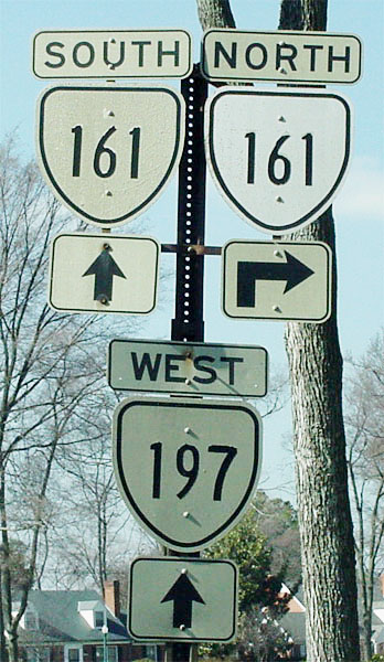
I-95 (exit 69): 0 - 0 US 1, US 301: 1.5 - 1.5 VA 10 EB: 3 - 4.5 VA 10 WB: 0.5 - 5 US 360: 0.5 - 5.5 US 60: 1 - 6.5 VA 195: 4 - 10.5 VA 147: 0.25 - 10.75 VA 315: 0.25 - 11 VA 6: 0.25 - 11.25 US 33, US 250: 0.5 - 11.75 I-64, I-95 (exit 78): 1 - 12.75 VA 197: 0.25 - 13 I-95 (exit 80): 1 - 14 HR-RIC LINE: 0 - 14 VA 356: 2 - 16 US 1: 1 - 17
|
Creation: Appeared in July 1933 as a renumbering of VA 432. Ran from VA 147 Richmond to US 1 Glenside. This has been the only VA 161.
| Adjustments: VA 161 was extended south to US 1-301 between 1942-44 over Belt Blvd (which existed over James River and all the way around to current US 1/301-Belt Blvd jct in 1934). In 1994, VA 161 was rerouted below VA 10 to its current end near the Phillip Morris Plant. Posting: Fully posted; cutouts (thanks Gribblenation) exist at jct with VA 197; error US 161 signs on Broad St. EB (verified 7/13/03, at least 15 years like this now) and at US 360 (replaced recently); white border sign NB VA 161 near VA 356. Comment: VA 161 passes through some nice areas in Richmond. Has 3 exits with I-95. |
|||||||||
|
|
|
| ROUTE LOG |
VA 143: 0 - 0 WIL-JC LINE: 0.22 - 0.22
|
Creation: Implied on maps back to 1947. Explicitly shows up for the first time on the 1957 historical map of Williamsburg. Ran from VA 168 (curr VA 143) to US 60 (curr US 60-VA 5) Williamsburg. This was not previously numbered but at one time may have been VA 286. This is the 2nd VA 162.
| Adjustments: Extended through downtown Williamsburg to US 60 on the opposite side of town in 1979. This multiplexed over VA 5-31 (curr VA 5) and replaced VA 132 west of downtown. VA 162 was truncated to its current form in 1994, leaving behind unnumbered roads. Posting: Still fully posted at VA 143. Comments: Not sure the point of it anymore... | Previous VA 162's: | VA 162 #1: Appeared in July 1933 as a renumbering of VA 436. Ran from VA 5 (curr US 250) Shannon Hill south to Tabscott. It was downgraded to SR 606 between 1942-44. | |||||||
| VA 163 not currently assigned | ||||||||||||||||
| Previous VA 163's: |
VA 163 #1: Appeared in July 1933 as a renumbering of VA 424. A stub off US 60 to Roxbury. This was downgraded to SR 609 between 1942-44. Today it is part of VA 106.
VA 163 #2 Appeared by 1957 (shown a la VA 162) but could be older, as a new routing. It was Parkway Dr. in Williamsburg. It ran from US 60 to VA 162, and provided access to the Colonial Pkwy. on the east side of town. This was decommissioned to an unnumbered road in 1994. while still active, it was posted only in cutouts and white border signs. |
|||||||||||||||
|
|
|
| ROUTE LOG |
US 17: 0 - 0 I-664 (exit 9): 0.5 - 0.5 VA 135: 0.5 - 1 POR-SUF LINE: 0 - 1 US 58, VA 337 ALT: 6 - 7
|
Creation: First appeared as dotted lines on the 1976 VDOT state map as a new freeway route. The first piece to actually exist was the bridge over Western Elizabeth River in 1978. This is the 3rd VA 164.
| Adjustments: Around 1990-91, VA 164 was open from the bridge to VA 135. It was finished to US 17 in 1992. A partial opening of a direct connection to US 58 was opened Sept. 2004 (project began in late 2001) Posting: Fully posted. Before the Pinner Point interchange was built, here were NO VA 164 signs in the neigborhood between the bridge and US 58, and good luck to you trying to do that connection. Comment: A nice, modern freeway. Maybe could be I-164 someday. Much, much more info is at Scott Kozel's page. | Previous VA 164's: |
VA 164 #1: Appeared in July 1933 as a renumbering for VA 501. Ran from US 58 to US 60 in Virginia Beach over today's Laskin Rd. In 1940 or 1941, a second piece of VA 164 appeared, running from VA 165 Princess Anne to Nimmo. The second piece was renumbered as current VA 149 by 1944. The original piece was renumbered as part of US 58 in 1956.
VA 164 #2: To my surprise, the 1956 VDOT map shows VA 164 running from US 58 to US 60 in Virginia Beach, using 17th street. Hmmmm. At any rate, up to 1955 this had been part of US 58. In 1957 this became US 58 Bus. |
|||||||
|
|
|
| ROUTE LOG |
US 17 Bus: 0 - 0 US 17: 4 - 4 VA 168 Bus NB: 4 - 8 VA 168 Bus SB: 0.25 - 8.25 VA 168: 0.75 - 9 VAB-CHE LINE: 7.5 - 16.5 VA 149: 3 - 19.5 VA 350: 3.5 - 23 VA 190: 4.5 - 27.5 NOR-VAB LINE: 2.5 - 30 US 58: 1 - 31 VA 165Y: 1 - 32 US 13 NB, VA 166 NB: 0.5 - 32.5 US 13 SB, VA 166 SB: 0.25 - 32.75 I-64 (exit 281): 0.5 - 33.25 VA 192: 0.5 - 33.75 VA 247: 0.25 - 34 VA 170: 2 - 36 VA 194: 0.25 - 36.25 VA 168: 0.5 - 36.75 I-64 (exit 276C): 0.5 - 37.25 US 460: 0.25 - 37.5 VA 337: 1.5 - 39
|
Creation: appeared in July 1933 as a renumbering of VA 502. Ran only from US 460 (curr US 13-VA 166) to VA 27 (curr VA 168 Bus) Great Bridge via Princess Anne. This has been the only VA 165.
| Adjustments: By July 1936, VA 165 was extended north over new routing to US 60 (this was using Diamond Springs Road). This extension was renumbered as VA 13 in 1938, and VA 165 returned to its original 1933 route. Between 1942-44, VA 165 was extended north and west along Military Hwy, Little Creek Rd, and Taussig Blvd., then across a ferry to Newport News, ending at VA 168 (curr VA 143). None of this was previously numbered. Between 1945-47, VA 165 north was rerouted to its current end at VA 337, using Military Hwy and Little Creek Rd (replacing VA 351 #2). Taussig Blvd. and the Newport News stub both became part of VA 168 (today this is I-564, VA 337, no ferry, and a piece of VA 167 if it still exists) In 1963 or 1964, VA 165 was extended from Great Bridge to VA 166 (curr VA 104) over what was SR 640. In 1966, VA 165 was extended again to US 17 Deep Creek over what was VA 166. Posting: Fully posted. A. Froehlig reports an error US 165 sign EB between US 460 Wards Corner and I-64; In the late 90's there was an error US 165 sign SB at VA 247 (A. Froehlig reports in July 2005 this is still here) Comment: Obviously nobody wanting to drive from Deep Creek to Norfolk Naval Base would consider doing VA 165 end to end... |
|||||||||
|
|
|
| ROUTE LOG |
VA 165: 0 - 0 VA 165Y END: 0.5 - 0.5
|
Water Works Rd. (near jct. US 13 & VA 166). This is not posted. Created between 1948-56. Once formed a triangle with VA 165 and US 13-VA 166 but was broken up by I-64 in the 60's. This was mainline US 13-VA 13. Why this is still active is beyond me.
| |
|||||||||
|
|
|
| ROUTE LOG |
US 17: 0 - 0 VA 190: 2 - 2 US 13, US 460 WB: 0.5 - 2.5 I-464 (exit 3): 0.5 - 3 VA 337: 1.5 - 4.5 VA 246: 0.25 - 4.25 NOR-CHE LINE: 0.5 - 4.75 VA 168 SB: 0.5 - 5.25 I-264 (exit 11): 0.75 - 6 US 460 WB, VA 168 NB: 0.25 - 6.25 US 58: 0.25 - 6.5 VA 194: 2.25 - 8.75 US 13 SB, VA 165 NB: 1.25 - 10 VA 165 SB: 0.25 - 10.25 I-64 (exit 282): 0.5 - 10.75 VAB-NOR LINE: 0.25 - 11 US 13 NB: 1 - 12 VA 332: 0.25 - 12.25 US 60: 1.25 - 13.5
|
Creation: Appeared in July 1933 as a renumbering for VA 504. Originally ran from US 17 Deep Creek to VA 165 Kempsville, in a big zig zag (used what is current VA 190 below VA 165). VA 166 may have been 2 pieces or multiplexed with VA 27 (curr VA 190) - it is unclear - between Great Bridge and the curr. VA 166-VA 190 jct. This has been the only VA 166.
| Adjustments: Between 1942-44, VA 166 was definitely one piece, as VA 170 (which replaced VA 27) was moved to its Battlefield Blvd. corridor. In 1956, VA 166 was routed through Norfolk and extended out to US 60 Chesapeake Beach. The previous route to Great Bridge and Kempsville became VA 190. This new routing of VA 166 replaced VA 166Y, and was multiplexed over US 460 to Norfolk. From there it replaced both VA 13Y's on its way out to US 60. VA 166 used today's Shell Rd from today's Northampton Blvd.-Diamond Springs Rd. jct northeast to Pleasure House Road where it cut north to US 60 Shore Dr. The 1963 Official map shows Northampton Blvd as existing between Pleasure House Rd and US 60. VA 166 may have been put on this temporarily or possibly not. In 1964, VA 166 and US 13 swapped places at the Northampton Blvd.-Diamond Springs Road intersection. Only the Northampton Blvd. bridge over Lake Smith uses the Shell Rd alignment of old VA 166. Pleasure House Road was briefly SR 651 after this switch. In 1966, VA 166 South was truncated to its current end, replaced by VA 165 from Deep Creek to VA 104, and by VA 104 to the VA 104-VA 166 jct. Posting: Fully posted, except there are NO VA 166 signs in the city of Virginia Beach. There are VA 166 signs with US 13 east of I-64 while still in Norfolk, although VA 166 is NOT referenced from I-64 at all. Per A. Froehlig, some "TO US 13" shields have appeared WB heading into Norfolk from Military Hwy. I guess these were installed in the wrong direction. Also, there are VA 166 shields at the Diamond Springs/Weslyan Dr. intersection, which is funny because a) Diamond Springs Rd is not VA 166 here and b) these signs have been up since 1993 - in fact if you were to follow VA 403 you might run across this set up and be a little confused. Comments: VA 166 east of Norfolk is all original concrete 4-lane routing. | Previous VA 166's: | VA 166Y: Appeared between 1942-44, running from US 13-460 (curr US 13-460 split) to VA 166 (curr VA 166-VA 190 jct). This was a replacement for a piece of VA 170. VA 166Y was renumbered as part of mainline VA 166 in 1956. |  |
||||||
| VA 167 not currently assigned | |||||||||||||||
| Previous VA 167's: |
VA 167: Appeared in July 1933 as a renumbering of VA 511 and VA 513. Originally ran from the James River in Indian River section of Newport News to Grand View (north of Buckroe Beach).
In 1940-41 VA 167 east was rerouted to end at VA 168 (curr VA 351) Buckroe Beach, leaving behind SR 616 to Grand View also VA 167 west was extended along Chesapeake Dr. to the Newport News city limit. Between 1948-50, VA 167 west was extended to VA 168 (curr Jefferson Ave. at Monitor Merrimac Memorial Hwy now unnumbered). In 1958, VA 167 west was extended north over what had been part of VA 168 to VA 143 at 28th St. Between 1968-70, VA 167 was given a more N-S alignment by running up Armistead Blvd. over what at one time was VA 134. VA 167 to Buckroe Beach became part of VA 169. In 1972, this new alignment was shifted east over new routing to go directly to Langley AFB. Armistead Ave. went unnumbered after that. The November 1995 CTB minutes show and the 2001 and 2003 VDOT logs confirm that VA 167 has been decommissioned, presumably to an unnumbered route. However, it is on the 2000-01, 2002-04, and 2004-06 VDOT state maps. On the other hand, VA 167 markers were not removed from I-64 BGS's until late 1999. A. Froehlig reports no VA 167 signs are on the ground anywhere. |
||||||||||||||
|
|
|
|
| ROUTE LOG |
US 60: 0 - 0 US 460: 1 - 1 VA 165: 2 - 2 I-64 (exit 277): 0.25 - 2.25 VA 247: 2 - 4.25 US 58: 1.75 - 6 US 460 EB, VA 337: 0.25 - 6.25 VA 166 NB: 0.25 - 6.5 I-264 (exit 11): 0.25 - 6.75 US 460 WB, VA 166 SB: 0.75 - 7.5 CHE-NOR LINE: 0.25 - 7.75 VA 246: 0.25 - 8 US 13: 2.5 - 10.5 I-64 EB (exit 290), VA 168 Bus: 0.75 - 11.25 I-64 WB (exit 291), I-464 (exit 1), US 17 NB: 1 - 12.25 US 17 SB: 0.25 - 12.5 VA 168 Bus: 2.5 - 15 VA 165: 2.5 - 17.5 VA 168 Bus: 1 - 18.5 VA 168 Bus: 5 - 23.5 VA 168 Bus: 3 - 26.5 NC STATE LINE: 0.5 - 27
|
Creation: Appeared in July 1933 as what appears to be a newly numbered route. Ran from US 17 (curr US 17-VA 143-VA 306 jct) south to 34th St. Newport News then east to VA 169 Buckroe Beach. This has been the only VA 168.
| Adjustments: By July 1936, VA 168 was extended north along a new road all the way to VA 170 (curr VA 238) Lee Hall. In 1940 or 1941, VA 168 was extended north again over new road to VA 33 (curr VA 30-VA 33-VA 249 jct). Between 1945-47, VA 168 from Jefferson Ave to Buckroe Beach was renumbered as VA 351 #3. Instead, VA 168 continued south along Jefferson to a ferry over Hampton Roads. It picked back up at Norfolk Naval Base and headed down Taussig Blvd. and Little Creek Rd. to end at US 60 Little Creek. In Norfolk this replaced VA 165 from Newport News to Military Hwy-Little Creek Rd. jct, and VA 351 #2 east of there. In 1958, VA 168 made some big changes: From I-64 jct with US 258 to Ocean View, VA 168 was put onto the completed I-64 (the 1958 map labels this only as VA 168) and jogged over on US 258 to Jefferson Ave. In Newport News Jefferson Ave. became part of an extended VA 143. Once in Ocean View, VA 168 was routed down Tidewater Dr. (new road) to downtown Norfolk. The previous VA 168 alignment in the Southside became VA 170. VA 168 continued south over what had been VA 170 all the way to NC. Between 1959-61, VA 168 was extended west along I-64 to the VA 143 exit near the airport. Jefferson Ave south of this exit became more of VA 143. In 1966, VA 168 North was added to the new I-64 all the way to Camp Peary. Again the old 168 became more of VA 143. In 1973, VA 168 was sent to US 60-VA 30 jct over VA 168Y, leaving behind the more direct SR 746. In 1974, VA 168 was added to new I-64 out to current Exit 227. The route to US 60-VA 30 became VA 168Y #2. In 1980, VA 168 was eliminated north of US 60 Ocean View. The only non-multiplexed part of VA 168 became an extended VA 249 (curr VA 30). In 1981 the Great Bridge Bypass was opened. This was connected to I-64 at the I-464 south end via the new Oak Grove Connector about 1998. Finally, VA 168 TOLL below Great Bridge was opened in 2001. In these last three cases, VA 168 Business was assigned to the old route. Posting: Fully posted Comments: From Dave The major route from the Norfolk area to the Outer Banks. A friend of mine designed part of the toll limited-access replacement of VA 168 from Great Bridge to the state line, which is currently being built. NC 168 will also be upgraded, although I don't know if it will be limited access. A freeway in Currituck Co....never thought I'd see that. | Previous VA 168's: |
VA 168Y #1: Appeared in 1940-41 as a newly numbered route. Ran from US 60-VA 30 jct east to VA 168 (curr SR 746). This was replaced by mainline VA 168 in 1973. Today it is part of VA 30.
VA 168Y #2: Appeared in 1974. Ran from US 60-VA 30 jct east to I-64/VA 168. This replaced an alignment of VA 168. This was renumbered as part of VA 30 in 1981. |
||||||
|
|
|
| ROUTE LOG |
I-64 (exit 268), US 60: 0 - 0 VA 143: 0.5 - 0.5 US 258: 0.5 - 1 VA 351: 1.5 - 2.5 US 258: 5 - 7.5
|
Creation: Appeared in July 1933 as a renumbering of VA 512. Ran only from US 60 (curr VA 143) Phoebus to VA 168 (curr VA 351) Buckroe Beach. This has been the only VA 169.
| Adjustments: Between 1968-70 VA 169 was extended through Buckroe Beach back to US 258 as today, replacing a part of VA 167. In 1984, VA 169 was extended to I-64/US 60 over an unnumbered route. Posting: Fully posted Comment: Comprised of Mallory St., Old Buckroe Rd., Fox Hill Rd. |
||||||||
| US 170 |
|
|
|
| ROUTE LOG |
VA 165: 0 - 0 VA 192: 1.5 - 1.5 US 60: 1 - 2.5
|
Creation: Appeared in 1958, as a renumbering of the southside portion of VA 168. This is the 3rd VA 170. It ran from US 60 Little Creek to VA 337 Norfolk Naval Base via Taussig Blvd.
| Adjustments: In 1980, VA 170 west was truncated to its current end. This left behind I-564 and VA 337 on Taussig Blvd. Posting: Fully posted. A. Froehlig reports that VA 170 shields are still up coming out of GATE 3 of Norfolk Naval Base. Comment: E. Little Creek Rd. | Previous VA 170's: |
VA 170 #1: Appeared in July 1933. Ran from US 60 Lee Hall to US 17 Yorktown (replacing VA 514), then east to Moore Hall (replaced VA 518). VA 170 was renumbered as VA 238 in 1941. Note that VA 170 from Lee Hall to Yorktown was part of US 17 up to 1931.
VA 170 #2: Appeared in 1941 as a renumbering of original VA 27. Ran from US 17 Tabb to NC Line near Moyock NC. VA 170 used Magruder Blvd. and some of current VA 172 to get from US 17 down to Hampton. Once in Norfolk, VA 170 used Granby St. to downtown and Dominion Blvd to Great Bridge, the VA 168 Business to NC. Between 1942-44, the Hampton portion of VA 170 became VA 134 (today it is part of VA 134 and VA 172) and the Norfolk side was rerouted over Campostella Rd. to get to Great Bridge. The old route to Great Bridge became parts of US 460 and VA 166. In 1958, most of VA 170 was renumbered as VA 168, except Granby St. which became US 460. |
||||||
|
|
|
| ROUTE LOG |
VA 143: 0 - 0 I-64 (exit 256): 1.5 - 1.5 YO-NNS LNIE: 0.5 - 2 US 17: 1 - 3 VA 134: 0.25 - 3.25 POQ-YO LINE: 2.25 - 6 VA 172: 1 - 7 END VA 171: 5.5 - 12.5
|
Creation: Appeared in July 1933 as a new route. Started out as a short stub from VA 172 (curr VA 171-172 jct) Poquoson west for 1 mile. This is the 2nd VA 171.
| Adjustments: Between 1945-47, VA 171 was extended west to US 17-VA 134 jct Tabb (slightly south on VA 134 at Theater Rd-Yorktown Rd-VA 134 jct today). In 1976 VA 171 was extended east over VA 172 to Messick Pt. except VA 171 was placed on new primary alignment using Little Florida Rd. over to Poquoson Ave and on east to Messick Pt. The portion of Poquoson Ave between Wythe Creek Rd and Little Florida Rd became unnumbered. Wythe Creek Rd. between Poqouson Ave and Yorktown Rd became the last northern piece of today's VA 172. Also in 1976 VA 171 was placed on today's Victory Blvd from today's VA 172 west to Yorktown Rd. The old VA 171 using Yorktwon Rd northeast to today's VA 172 north end became SR 782 (unnumbered today). In 1986-87, VA 171 was rerouted onto more new Victory Blvd like it is today over to US 17. The old route became SR 706 Yorktown Rd. In 1999 VA 171 west was extended to I-64 over a road that had been opened in 1992 as unnumbered routing. In 2002 VA 171 west was extended again to VA 143. Posting: fully posted. When I drove to Messick Pt. in 1993, there was a cutout WB near the end. A. Froehlig reports that as of August 2004 VA 171 is not posted anywhere east of VA 172. Comment One of the two VA routes to enter Poquoson, the 8th and least known city of Hampton Roads. Lou Corsaro reports VA 171 has a 4-lane ROW everywhere west of VA 172 (an expressway?), even though the road is 2-lane for quite a ways. A. Froehlig reports VA 171 is limited access between just west of VA 172 and just west of I-64. VA 171 is 6-lanes between VA 143 and US 17. | Previous VA 171's: | VA 171 #1: Appeared in 1923 as a new route, running from VA 17 (curr VA 42) Buffalo Gap to VA 33-39 (curr US 11-250) Staunton. This was renumbered as VA 810 in 1929. Today it is part of VA 254. | ||||||
|
|
|
| ROUTE LOG |
VA 134: 0 - 0 POQ-HAM LINE: 2 - 2 VA 171: 3 - 5 END VA 172: 1 - 6
|
Creation: Appeared in July 1933 as a renumbering of VA 516. Ran from VA 27 (curr VA 134 connector) to Messick Pt. This is the 2nd VA 172.
| Adjustments: In 1963 or 1964, VA 172 was extended south over VA 134 to its current end at VA 134. In 1976, VA 172 east of Poquoson was renumbered as part of VA 171 and VA 172 was given the stub ending it has now. Poquoson Ave between Wythe Creek Rd and Little Florida Rd became unnumbered in this 171-172 switch, as VA 171 was placed on Little Florida Rd. Posting: Fully posted Comments:The other of the two VA routes to enter Poquoson, the 8th and least known city of Hampton Roads. Also serves a remote part of Langley AFB. | Previous VA 172's: | VA 172 #1: Appeared in 1923 as a new route. Ran from VA 17 (curr VA 42) Goshen southwest to Rockbridge Alum, then southeast to VA 14-33 (curr US 11 Bus-US 60 jct) Lexington. Between 1924-27 this became part of VA 14 and VA 335. Today it is US 60, some of SR 850, and all of SR 780. | ||||||
|
|
|
| ROUTE LOG |
BEGIN VA 173: 0 - 0 US 60: 2 - 2 VA 143: 1 - 3 YO-NNS LINE: 1 - 4 US 17: 2.5 - 6.5 SR 629: 4.5 - 11
|
Creation: Appeared in July 1933 as a renumbering of VA 517 and VA 528. Has the same endpoints as it does now. This has been the only VA 173.
| Adjustments: VA 173 used to run to US 17 between Tabb and Grafton and multiplex to Grafton before heading east to Dandy. VA 173 was given its current straighter alignment in 1978, leaving behind SR 620. Posting: Fully posted Comments: Denbigh Blvd. Denbigh was the county seat of Warwick Co. before it was engulfed by Newport News. VA 173 is blown off by I-64. |
||||||||
|
|
|
| ROUTE LOG |
VA 457: 0 - 0 MAR-HE LINE: 1.25 - 1.25 VA 108: 1.75 - 3 US 220 Bus: 2 - 5
|
Creation: Appeared in 1979 as a new route. ran only from US 220 Bus to VA 108. This is the 2nd VA 174
| Adjustments: VA 174 overran VA 108 to its current end in Martinsville in 1992. Posting: Assumed to be fully posted Comment: This breaks the pattern. Today's VA 174 is nowhere near either Hampton Roads or the Eastern Shore. But we once had... | Previous VA 174's: | VA 174 #1: Appeared in July 1933 as a renumbering of VA 519. Was a short cut-off between US 60 and VA 170 (curr VA 238) near Lee Hall. This was decommissioned in 1967, as I-64 was built through. If any of this still exists it is at the Yorktown Weapons Station. Was not shown on VDOT state maps in the 50's, except on the 1957 Williamsburg Tourist Map (reverse). | ||||||
