
< 201 to 225 | Home | 251 to 275 > | |||||||||||||||||||||||||||||||||||||||||||||||||||||||||||||||||||||||||||||||||||||||||||||||||||||||||||||||||||||||||||||||||||||||||||||||||||||||||||||||||||||||||||||||||||||||||||||||||||||||||||||||||||||||||||||||||||||||||||||||||||||||||||||||||||||||||||||||||||||||||||||||||||||||||||||||||||||||||||||||||||||||||||||||||||||||||||||||||||||||||||||||||||||||||||||||||||
|
|
|
| ROUTE LOG |
US 460: 0 - 0 US 1, US 460 Bus: 3 - 3
|
Creation: Appeared between 1968-70 as a renumbering of US 460, which was routed to meet I-85. Ran as it does now, and is the 2nd VA 226.
| Adjustments: None Posting: Fully posted Comment: This should have been renumbered as US 460 Bus when they moved US 460 onto I-85 a few years back. | Previous VA 226's: | VA 226 #1 Appeared in July 1933 as a renumbering of VA 631. Ran from US 17 east towards Water View. This was downgraded to SR 640 between 1942-44. | |||||||
|
|
|
| ROUTE LOG |
VA 33: 0 - 0 SR 602: 2.35 - 2.35
|
Creation: Appeared in July 1933 as a renumbering of VA 30, which used to turn east at West Point and end in Urbanna. Ran as it does today. This has been the only VA 227.
| Adjustments: None Posting: Fully posted; 2 "TO VA 227" cutouts exist on SR 602 EB between US 17 and Urbanna. Comment: I know it has to do with funding and all, but it aggravates me when a road is posted like SR 602 as "TO VA 227" for several miles from US 17 (prominently, I might add). Just call it VA 227 already. |
|||||||||
|
|
|
| ROUTE LOG |
VA 7: 0 - 0 SR 657: 4 - 4
|
Creation: Appeared in 1967 as a renumbering of the northern piece of VA 28. Ran as it does now. This is the 2nd VA 228.
| Adjustments: None Posting: Fully posted; All through Herndon there are truck route signs for VA 228 and SR 606...except they all say VA 606 instead of SR 606. Comment: Dranesville Rd. and various streets in Herndon. VA 228 does NOT touch VA 267. VA 228 ends at the Herndon town line about 1/2 mile north of VA 267. | Previous VA 228's: | VA 228 #1: Appeared in July 1933 as a renumbering of VA 632. Ran from VA 3 Emmerton to Sharps. This was downgraded to SR 642 in 1952. | |||||||
|
|
|
| ROUTE LOG |
US 15 Bus, US 29 Bus: 0 - 0 US 211: 13.73 - 13.73
|
Creation: Appeared between 1948-50 as a renumbering of some of VA 29 (Culpeper to near Jeffersonton), and some new alignment. Ran as it does today. This is the 3rd VA 229.
| Adjustments: None Posting: Fully posted Comment: Not much use as a through route. suggested VA 229 should be extended south through Culpeper to eliminate current VA 299. | Previous VA 229's: |
VA 229 #1: Appeared in July 1933 as a new route. Was a stub north off US 17 to Port Royal. Between 1934-37, this became part of VA 207. Today it is part of US 301.
VA 229 #2: Appeared between 1934-37 as a renumbering of a piece of VA 207. Ran from US 1 Ladysmith to VA 51 (curr SR 738) Chilesburg. This was downgraded to SR 639 between 1942-44. |
|||||||
|
|
|
| ROUTE LOG |
US 33 Bus: 0 - 0 MA-GR LINE: 4 - 4 US 29 SB: 7 - 11 US 29 NB, VA 231 NB: 1 - 12 VA 231 SB: 1 - 13 US 15: 8 - 21
|
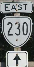
Creation: Appeared in July 1933. Started out in 4 pieces: 1. US 29 North Garden northwest for 5 miles. This replaced VA 700. 2. VA 5 (curr VA 240) Crozet to Boonesville. 3. Nortonsville to VA 4 (curr US 33) near Standardsville. Pieces 2 and 3 had been part of VA 704. 4. Madison-Greene County line to Madison, then due east to just short of US 15 Locust Park. West of Madison was part of VA 704. East of Madison was VA 722. This has been the only VA 230.
| Adjustments: Pieces 2 and 3 were made continuous in 1937. In 1938, Piece 4 became continuous with pieces 2-3. Between 1942-44, piece 1 was downgraded to SR 692 and the larger piece of VA 230 was extended south of Crozet to US 250, replacing what had been part of US 250. Meanwhile, VA 230 was truncated on the other end to US 29 south of Madison. Between 1945-47, VA 230 was extended east to US 15 Madison Mills, replacing what was VA 27. In 1951, VA 230 assumed its current routing, as the 29 miles between Standardsville and Crozet were downgraded to SR 810. The piece from Crozet to US 250 became part of an extended VA 240. Posting: Fully posted; cutouts at VA 230-231 jct. Comment: A scenic ride in the foothills. | Previous VA 230's: | VA 230Y: Mentioned in CTB minutes as being decommissioned in May 1950. VA 230Y was at the US 33-VA 230 jct (curr US 33-SR 810 jct) west of Standardsville. | |||||||
|
|
|
| ROUTE LOG |
VA 22: 0 - 0 LO-AL LINE: 8.5 - 8.5 OR-LO LINE: 0.5 - 9 US 15, US 33 EB: 1.5 - 10.5 US 33 WB: 0.5 - 11 VA 20: 6 - 17 MA-OR LINE: 1 - 18 VA 230 EB: 9 - 27 US 29 SB, VA 230 WB: 1 - 28 US 29 NB, BEGIN US 29 Bus: 1 - 29 US 29 Bus NB: 1 - 30 RA-MA LINE: 11 - 41 US 522: 10 - 51
|
Creation: Appeared in July 1933 in 3 pieces: 1. VA 22 Cismont to US 15-VA 4 (curr US 15-33) Gordonsville. This had been VA 701. 2. Rapidan River north of Somerset to 2 miles west of Criglersville. This had been VA 701 south of Madison and VA 705 north of Madison. 3. VA 340 (curr US 340 Bus) Stanley to VA 266 (curr SR 689) near Ida. That's right! Current VA 231 once existed west of the mountains! This piece was VA 836. This is the 2nd VA 231.
| Adjustments: Pieces 1 and 2 were connected in 1938. Between 1939-41, VA 231 was given the VA 230-US 29 multiplex it has today in the Madison area, leaving behind the more direct SR 687. Between 1945-47, piece 3 was renumbered as part of VA 266. Today it is SR 689. Also in this timeframe, VA 231 was removed from Criglersville (leaving behind SR 670) and routed north over VA 27 to US 522 Sperryville. Posting: Fully posted; a couple cutouts in Gordonsville and at the VA 230-231 jct. On March 20, 2004 I observed error US 231 signs at the SR 609 intersection near Barco. Comments: The piece from then-VA 27 to Criglersville may have been a separate 4th piece as there may not have been a multiplex with VA 27 north of Madison. The DeLorme Gazeteer shows a crude road connecting the Criglersville piece to the piece in Stanley. Perhaps it had been envisioned connecting them up. Entire route is a Virginia Scenic Byway. In Rappahannock Co., this route is F.T. Valley Road. Wonder what F.T. stands for. | Previous VA 231's: | VA 231 #1: Created in 1923, running from VA 23 (curr US 460) Rich Creek north to then-WV 24. It was renumbered as VA 216 in 1929, but today it is US 219. |  VA 231 in 1928. |
||||||
|
|
|
| ROUTE LOG |
I-81 (exit 105): 0 - 0 RAD-MO LINE: 0.25 - 0.25 US 11: 3.75 - 4
|
Creation: Appeared as an upgrade to SR 605 between 1968-70 in its current form. This is the 3rd VA 232.
| Adjustments: None Posting: Fully posted; strangely bold shields on US 11 SB. Comment: The 1967 state map cover shows a picture of the I-81 exit with VA 232 (then SR 605), but the map itself does not show an exit. The 1970 map incorrectly shows 232 as a secondary route. | Previous VA 232's: |
VA 232 #1: Appeared between 1924-27 as new routing. Ran from VA 12 (curr US 58) Hillsville to US 311 (curr US 220 Bus) Roanoke. This was renumbered as VA 205 in 1929. Today it is US 221.
VA 232 #2: Appeared in July 1933 as a renumbering of VA 706. Ran from VA 16 (curr VA 231) Revercombs Corner to Slate Mills. By 1937, VA 232 was extended east to VA 3 (curr US 522) Boston. This was downgraded to SR 707 between 1942-44. |
|||||||
|
|
|
| ROUTE LOG |
US 1: 0 - 0 GW PKWY: 0.36 - 0.36
|
b>Creation: Appeared in its present form between 1968-70. This is the 2nd VA 233.
| Adjustments: None Posting: Fully posted, but no mention from GWMP. Original cutouts lasted until early 2001. Comment: Provides quick vehicle access from Crystal City to the airport. | Previous VA 233's: | VA 233 #1: Appeared in July 1933 as a renumbering of VA 708. Originally ran only from VA 17 (curr US 17) Morrisville to Bristerburg then Catlett, then east to the Prince William County Line. By 1937 VA 233 was extended over unnumbered roads to VA 28 (curr VA 215) Bristow. In 1940 or 1941, VA 233 was truncated to Catlett, as VA 28 was rerouted to Remington instead of New Baltimore. VA 233 was downgraded to SR 806 in 1951. |  VA 233 in 1941. |
||||||
|
|
|
| ROUTE LOG |
US 1: 0 - 0 I-95 (exit 152): 0.5 - 0.5 VA 234 Bus: 14 - 14.5 VA 28: 4.5 - 19 I-66 WB (exit 44): 5 - 24 I-66 EB (exit 47), VA 234 Bus: 3 - 27 VA 393: 0.5 - 27.5 US 29: 0.5 - 28 US 15: 7 - 35
|
Creation: Appeared in July 1933 in 2 pieces: 1. US 1 Dumfries to US 15-50 Gilbert's Corner. This replaced VA 709. 2. 1 mile south of VA 7 Purcellville to then-MD 33 (curr MD 17) at Brunswick MD. This was a renumbering of VA 721. This has been the only VA 234.
| Adjustments: In 1941, piece 1 was rerouted to end at US 15 where it does now. The direct route from Manassas to US 50 became SR 705 and a little of US 15. Also, piece 2 was renumbered as a piece of VA 17. Today this piece is mostly VA 287 and a little SR 690. Instead, another separate piece appeared as a stub from VA 7 to Bluemont, replacing what was VA 245 (see scan at right). This stub was downgraded to SR 734 between 1942-44. VA 234's bypass was opened in 1998, but only from I-66 to VA 28. The completion to VA 234 south of town opened in mid to late 2001. Posting: Fully posted; there is a 234 cutout on VA 28 NB just past 234 Bypass in Manassas, attached to a medium green sign. VA 234 signs in circles appeared on the newly completed 4-lane section around Lake Jackson, but were quickly replaced with the correct shields. Additionally, VA 234 reassurance signs have appeared on I-66, and at the 234 Business exit in Manassas signs clearly indicate a VA 234 multiplex with I-66. In April 2005 Dan F reports 234 in circles at Richmond Ave in Manassas. Comment:VA 234 is now 4-lane from I-66 south to nearly Independent Hill, with widening all the way to Dumfries on the horizon. The bypass is incorrectly shown open south of VA 28 on the '98 VDOT map.  VA 234 in 1941. |
|||||||||
|
|
|
| ROUTE LOG |
US 1: 0 - 0 GW PKWY: 3 - 3 US 1: 2 - 5
|
Creation: Appeared in its present form in July 1933. This was a renumbering of VA 710 and VA 723. This has been the only VA 235.
| Adjustments: None Posting: Fully posted Comments: Mount Vernon Highway. Loop from US 1 to George Washington's home. Also contains the last piece of US Bike Route #1, which is fully posted in VA and NC. Also serves the southern terminus of the George Washington Memorial Parkway, although there are no signs telling you how to get to it. |
|||||||||
|
|
|
| ROUTE LOG |
US 29, US 50: 0 - 0 VA 123: 1 - 1 VA 237: 2 - 3 FX-FAX LINE: 0 - 3 VA 376: 2 - 5 I-495 (exit 52): 1 - 6 VA 244: 1 - 7 ALX-FX LINE: 3.5 - 10.5 I-395 (exit 3): 0.5 - 11 VA 401: 0.5 - 11.5 VA 402: 2.5 - 14 VA 241: 1 - 15 US 1: 1 - 16
|
Creation: Appeared between 1934-1937 as a replacement for US 50. This is the 2nd VA 236.
| Adjustments: None Posting: Fully posted; some circle signs in Fairfax City; white border signs each direction at VA 241 (verified March 2002). Comment: Duke St., Little River Turnpike, Main/North Sts. I finally got some early 30's VDOT Maps to verify how VA 236 behaved. | Previous VA 236's: | VA 236 #1: Appeared in July 1933 as new routing. Ran from US 50-VA 9 (curr VA 123-236 jct) over today's Old Lee Hwy and Arlington Blvd. to end at VA 237 Ft. Myer. By 1937 this VA 236 was renumbered as US 50. Today it still is except for unnumbered Old Lee Hwy. | |||||||
|
|
|
| ROUTE LOG |
VA 236: 0 - 0 US 50 EB: 1.5 - 1.5 US 29 SB, US 50 WB: 0.5 - 2 FX-FAX LINE: 0 - 2 VA 243: 1 - 3 FAL-FX LINE: 3 - 6 VA 338: 1 - 7 VA 7: 0.5 - 7.5 AR-FAL LINE: 0.5 - 8 I-66 (exit 68): 0.5 - 8.5 US 29 NB: 0.25 - 8.75 VA 120 NB: 2.75 - 11.5 VA 120 SB: 0.5 - 12 US 50: 1.5 - 13.5
|
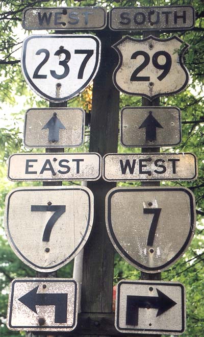
Creation: Appeared in July 1933, as a renumbering of VA 711 ('29 Official) or VA 712 ('32 Official). Ran from VA 236 (curr US 50) along Wilson Blvd. then over to US 211 (curr US 29) as it does now near Falls Church. This has been the only VA 237.
| Adjustments: VA 237 was moved to its Washington Blvd. alignment in 1940 or 1941. VA 237 was extended west along US 29 and Old Lee Hwy into downtown Fairfax in 1962. VA 237 was rerouted to its current ending between US 29 and VA 236 in 1988. Posting: Fully posted from US 29 SB (Pickett Rd is not posted at all), but not from VA 7. Cutout still up in Feb 2002 on VA 338 WB and at VA 7. Russ Blau reports that VA 237 between US 29 and VA 120 is also not posted, except at US 29, where there is a wrong-way VA 237 sign. Comment: This is a very strange, and some would say pointless, route. It starts at US 50 in Arlington, follows 10th St. N. and Fairfax Dr. to Glebe Rd. (VA 123), then north on Glebe to Washington Blvd., west to join with US 29 through Falls Church to Fairfax Circle, then east on US 50 for one block, and south on Pickett Rd. to VA 236. The dogleg at Fairfax Cir. is particularly bizarre, since a short section of Blake Lane provides a more direct route. |
|||||||||
|
|
|
| ROUTE LOG |
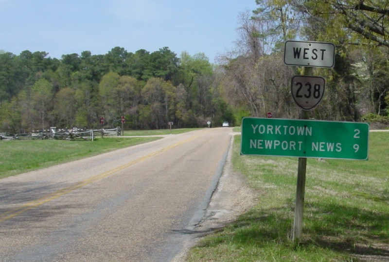
US 60: 0 - 0 I-64 (exit 247): 1 - 1 VA 143: 0.25 - 1.25 YO-NNS LINE: 1 - 2.25 US 17: 3.5 - 5.75 COLONIAL PARKWAY: 0.75 - 6.5 END VA 238: 1.5 - 8
|
Creation: Appeared as a renumbering of VA 170 in 1941. It had the same endpoints as today. This is the 2nd VA 238.
| Adjustments: VA 238 was rerouted to the south of Yorktown between in 1991 over Goosely Rd (SR 638). The old alignment into Yorktown became SR 1020. Posting: Fully posted; cutouts still remain in Yorktown and at its eastern endpoint (thanks Gribblenation!) Comment: Also serves Naval Weapons Station, Yorktown. Much of VA 238 was once US 17 until about 1932. | Previous VA 238's: | VA 238 #1: appeared in July 1933 as a renumbering of VA 713. Ran from VA 7 Clarks Gap to WV 9 towards Charles Town, WV. This was renumbered as VA 9 in 1941. Official Virginia maps continued to refer to VA 9 as VA 238 in its Wayside lists until at least 1947 (as a reference to find one on VA 7). | |||||||
|
|
|
| ROUTE LOG |
VA 337: 0 - 0 US 58, US 460 ALT: 0.5 - 0.5 I-264 (exit 3): 0.5 - 1 US 17: 2 - 3 VA 337: 2 - 5
|
Creation: Appeared between 1968-70 as an upgrade to SR 681. Ran from US 58-460 ALT portsmouth to VA 337 Jordan Bridge. This is the 2nd VA 239.
| Adjustments: VA 239 was extended west to VA 337 in 1984. Posting: Fully posted, but not identified on I-264 as anything other than Victory Blvd. Comment: VA 239 has the deepest median ditch I have ever seen. | Previous VA 239's: | VA 239 #1: appeared in July 1933 as a renumbering of VA 714. Ran from US 250 Charlottesville to Monticello. VA 239 was renumbered as part of VA 20 between 1942-44. Today it is part of VA 20 and VA 53. | |||||||
| US 240 |
|
|
|
| ROUTE LOG |
US 250: 0 - 0 US 250: 4.51 - 4.51
|
Creation: Appeared between 1942-44 as a renumbering of part of US 250. Ran from VA 230 (curr SR 810) Crozet to US 250 Mechums River. This is the 2nd VA 240.
| Adjustments: VA 240 was extended west back to US 250 (replacing part of VA 230) in 1951. Posting: Fully posted; cutout in Crozet Comment: A slow detour through Crozet instead of US 250. | Previous VA 240's: | VA 240 #1: Appeared in July 1933 as a renumbering of VA 716. Ran from VA 5 (curr VA 240) Brownsville to VA 5 (curr VA 240) Mechums River. This was renumbered as US 250 between 1942-44. | |||||||
|
|
|
| ROUTE LOG |
US 1: 0 - 0 I-95 (exit 175), I-495: 1.5 - 1.5 ALX-FX LINE: 0 - 1.5 VA 236: 0.5 - 2
|
Creation: Appeared in July 1933 as a renumbering of VA 717. Ran as it does today. This has been the only VA 241.
| Adjustments: None Posting: Fully posted, except not posted from VA 236 EB. In fact, it looks as if VA 236 went onto VA 241 with the way it is posted. (verified March 2002). In August 2003 Dan F reports VA 241 SB signage is gone where you have to make a turn at onto Kings Hwy. - going straight puts you on SR 611. Comment: Telegraph Rd., Kings Highway. Signage oddity: The control point for VA 236 west at the end of VA 241 is Cameron Station, a military installation which no longer exists! -- Dan F reports that this sign has been corrected... The 1944 Official map shows this as US 241 in error. |
|||||||||
|
|
|
| ROUTE LOG |
US 1: 0 - 0 SR 600: 3.58 - 3.58
|
Creation: Appeared in 1952 as an upgrade to part of SR 600. Ran as it does today. This is the 2nd VA 242.
| Adjustments: None Posting: Fully posted; VA 242 in an oval from SR 600 EB at the US 1 jct Comment: Gunston Rd. from patriot George Mason's home to US 1. This route could be considered coexistent with SR 600, since that is the number of the road on either side. At US 1 it is posted as VA 242 and TO SR 600. The 1952 Official State Map shows this as SR 242 in error. | Previous VA 242's: | VA 242 #1: Appeared in July 1933 as a renumbering of VA 718 (according to 1933 Conoco Map. No VDOT state maps '29-'32 number this). Started out in 2 pieces: 1. VA 3 (curr US 522) Flint Hill east to the Rappahannock River 2. VA 55 Marshall southwest for 4 miles. These 2 pieces were connected in 1939. In 1941, VA 242 was extended south from Flint Hill through Ben Venue to VA 29 (curr VA 229) Culpeper, replacing part of VA 49. Between 1942-44, VA 242 north was truncated to the Rappahannock River, leaving behind SR 647. Between 1945-47, VA 242 north was truncated to US 522 Flint Hill. VA 242 was downgraded to SR 729 between 1948-50. SR 729 has one of the few white border SR signs still in existence. | |||||||
|
|
|
| ROUTE LOG |
US 29, VA 237: 0 - 0 I-66 (exit 62): 0.5 - 0.5 VA 123: 1 - 1.5
|
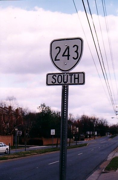
Creation: Implied to have been created between 1968-70, but explicitly appears in 1975. Ran as it does today. This the 2nd VA 243.
| Adjustments: None Posting: Fully posted; White border signs at VA 123; cutout heading SB from VA 123 (verified Spring 2004) in Vienna. Comment:Nutley St. from VA 123 to US 29, and site of the famed Vienna Metro Station. Note that not only is Nutley from US 29 to US 50 not part of 243, but has recently been reported to have been named SR 10230, which at the time was the highest number route in the USA (Fairfax County has reached at least SR 10350 now). | Previous VA 243's: | VA 243 #1: Appeared in July 1933 as a renumbering of VA 719. Originally ran from Amicus, south of VA 4 (curr US 33) Standardsville to US 29 Burtonsville. VA 243 was downgraded between 1942-44 to SR 622 south of Standardsville and SR 609 east of US 33. | |||||||
|
|
|
| ROUTE LOG |
VA 236: 0 - 0 VA 7: 4 - 4 AR-FX LINE: 0.5 - 4.5 VA 120: 1.75 - 6.25 VA 27: 1 - 7.25 VA 27: 1 - 8.25
|
Creation: Appeared in July 1933 as a renumbering of VA 720. Ran from VA 7 Baileys Crossroads to US 1 Arlington. This has been the only VA 244.
| Adjustments: Between 1934-37, VA 244 was extended west to VA 236 Annandale. By 1944, VA 244 east was truncated to its current end, although VA 27 was 20 years away from being signed there. It may have been at the original VA 350, but the 1944 map has no 350 shields on it. Posting: fully posted; VA 244 in a circle at EB VA 236 verified by Russ Blau as still present in March 2002. VA 244 in a circle spotted Feb. 2002 on VA 244 WB at VA 7; White border signs in the "neighborhood clover" around VA 120 jct. Comment: VA 244 is one-way WB at VA 236. To get to VA 244 from VA 236, you have to use SR 617 SB; Columbia Pike, or "Col. Pike" as the signs say at VA 236. |
|||||||||
|
|
|
| ROUTE LOG |
US 17: 0 - 0 I-66 (exit 31): 3 - 3 VA 55: 0.25 - 3.25
|
Creation: Appeared as renumbering of VA 17 between 1945-47. Runs as it does now, and is the 4th VA 245.
| Adjustments: None Posting: Fully posted Comments: This was part of US 15 until 1941. | Previous VA 245's: |
VA 245 #1: Appeared in July 1933 as a newly numbered route. Was a short stub from VA 7 to Bluemont. This was renumbered a far-separate piece of VA 234 in 1941. Today it is SR 734.
VA 245 #2: Appeared in 1941 as a renumbering of VA 120. Ran from VA 40 Ferrum north for 4 miles. This was downgraded to SR 602 by 1944. VA 245 #3: Appeared between 1942-44 as an upgrade to SR 710. Ran from VA 17 (curr VA 245) to VA 55 Marshall. This was renumbered as VA 17 between 1945-47. Today it is US 17. |  VA 245 in 1941. |
||||||
|
|
|
| ROUTE LOG |
US 460, VA 166: 0 - 0 VA 168: 1 - 1
|
Creation: Appeared between 1942-44 as an upgrade to SR 642. Originally ran from US 460 only to border of the former city of South Norfolk. This is the 2nd VA 246.
| Adjustments: Between 1945-47, VA 246 was extended east to VA 170 (curr VA 168), its current routing. Posting: Fully posted in 1991. A. Froehlig reports that in July 2005, VA 246 is not posted at VA 168 anymore. Also, there are a couple VA 246 postings west of its endpoint along US 460/VA 166 back to Bainbridge Blvd. No document either of us can find shows this as actually part of VA 246. Comment: Liberty St. in Chesapeake | Previous VA 246's: | VA 246 #1: Appeared in July 1933 as a renumbering of VA 723. Ran from VA 16 (curr VA 231) near Hawlin to VA 3 (curr US 522) Woodville. This was downgraded to SR 618 between 1942-44. | |||||||
|
|
|
| ROUTE LOG |
VA 337: 0 - 0 US 460: 1 - 1 VA 168: 1 - 2 VA 194: 2 - 4 I-64 (exit 279): 0.5 - 4.5 VA 165: 0.5 - 5
|
Creation: Appeared in 1963 or 1964. Ran from VA 337 to VA 168 Tidewater Dr. only. This was not previously numbered. This is the 2nd VA 247.
| Adjustments: VA 247 was extended to VA 165 in 1980. Posting: Fully posted, except not identified at all from I-64. Comments: Provides main access to Norfolk Int'l Airport; Norwood Ave., Chesapeake Blvd., Lafayette Blvd., 27th/26th Sts. | Previous VA 247's: | VA 247 #1: Appeared in July 1933 as a renumbering of VA 727. Short route southwest from VA 6 Holmhead towards the James River. This was downgraded to SR 656 between 1942-44. | |||||||
| VA 248 not currently assigned | |||
| Previous VA 248's: |
VA 248 #1: Appeared as a newly numbered route in July 1933. Was a short spur north off US 211 Washington, VA. This was downgraded to SR 622 between 1942-44.
VA 248 #2: Appeared between 1942-44 as an upgrade to SR 642. Was a short spur southeast off of US 33 (curr VA 22-208) Louisa. This became part of US 33 between 1945-47. | ||
|
|
|
| ROUTE LOG |
US 60, VA 33 WB: 0 - 0 I-64 (exit 205), VA 33 EB: 0.5 - 0.5 VA 106: 7 - 7.5 VA 155: 4 - 11.5 VA 30, VA 33: 7 - 18.5
|
Creation: Appeared as a renumbering of VA 33 in 1973. Ran as it does today. This is the 2nd VA 249.
| Adjustments: In 1980, VA 249 was extended east over VA 168 to VA 30 (curr VA 273) Barhamsvile. VA 249 was restored to its original routing in 1986, with the extension becoming VA 30. Posting: Fully Posted Comment: This is the main street of New Kent County | Previous VA 249's: | VA 249 #1: Appeared in July 1933 as a renumbering of US 60. Ran from US 11 Natural Bridge to US 501 Glasgow. This was renumbered as part of VA 130 in 1953. |  |
||||||
| US 250 |
| VA 250 not currently assigned | |||
| Previous VA 250's: | VA 250: Appeared in July 1933 as a renumbering of VA 802. Ran from VA 18 (curr US 220) to Crabbottom. This was renumbered as VA 284 in 1935. Today it is SR 642. | ||
Previous: VA 201 - 225 |
Next: VA 251 - 275
Top | Virginia Hwy Index
Home
