
< 226 to 250 | Home | 276 to 300 > | |||||||||||||||||||||||||||||||||||||||||||||||||||||||||||||||||||||||||||||||||||||||||||||||||||||||||||||||||||||||||||||||||||||||||||||||||||||||||||||||||||||||||||||||||||||||||||||||||||||||||||||||||||||||||||||||||||||||||||||||||||||||||||||||||||||||||||||||||||||||||||||||||||||||||||||||||||||||||||||||||||||||||||||||||||||||||||||||||||||||||||||||||||||||||||
|
|
|
| ROUTE LOG |
US 11: 0 - 0 LEX-RB LINE: 7 - 7 SR 770: 1 - 8
|
Creation: Appeared as a renumbering of VA 806 in July 1933. Ran from US 11 Lexington to US 60 Longdale Furnace. This is the 2nd VA 251.
| Adjustments: VA 251 west was truncated to Collierstown, leaving behind SR 770 between 1942-44. Between 1948-50, VA 251 was extended east about a mile when US 11 was rerouted (used current SR 764) in its southern approach to Lexington. Posting: Fully posted; cutout WB at US 11 jct Comment: A nice pleasant route. The road from Collierstown to Longdale Furnace looks quite adventurous on the DeLorme. | Previous VA 251's: | VA 251 #1: Appeared in 1928 as the longest 3-digit route of the 1920's system. This replaced the original versions of VA 212, VA 325, and VA 361. This was probably in several pieces, as it ran from US 11 & VA 33 Greenville to Waynesboro, Elkton, Front Royal, and Berryville. Then it ran east to Leesburg and ended at VA 25 (curr VA 123) Tysons Corner. In 1929, this was renumbered as VA 809 from Greenville to VA 17 (curr SR 996) McGaheysville, VA 815 from VA 17 (curr US 33 Bus) Elkton to VA 37 (curr US 522) Front Royal, VA 37 from Front Royal to Double Tollgate, and the rest to Berrysville and Tysons Corner became VA 54. Today, this is mostly US 340 and VA 7, except between Elkton and Grottoes, where it followed SR 672. | |||||||
|
|
|
| ROUTE LOG |
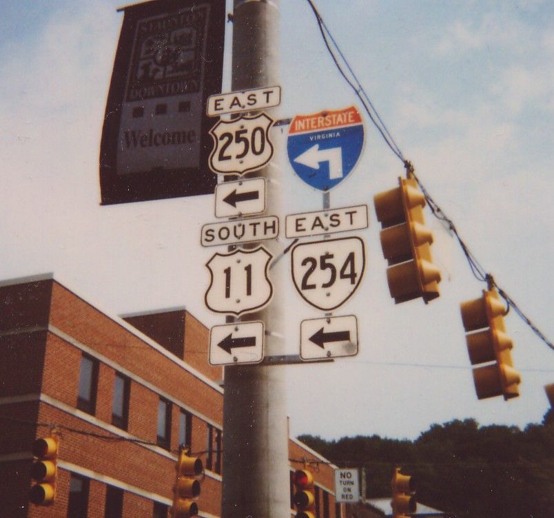
VA 39: 0 - 0 AU-RB LINE: 9 - 9 VA 262: 16 - 25 STA-AU LINE: 0 - 25 US 11 Bus, US 250: 2 - 27
|
Creation: Appeared in July 1933 in 2 pieces: 1. VA 501 (curr VA 39) to the Augusta County Line, replacing VA 808. 2. VA 42 Moscow south to Spring Hill, replacing VA 830. This has been the only VA 252.
| Adjustments: Piece 1 was extended north to VA 56 (curr SR 620) Newport in 1938. By 1941, a 3rd piece formed, in between the first 2 pieces: US 250 Staunton south to the westernmost piece of VA 56 (curr SR 876) Middlebrook. Pieces 1 and 3 were joined between 1942-44 (creates current VA 252). Piece 2 was downgraded to SR 607 between 1945-47. I cannot locate a map to prove it, but the northern end was switched to US 11 south of US 250 east for a little while in the mid-to-late 90's, but today is back at downtown Staunton Posting: Fully posted; cutouts in Staunton; VA 252 NB has a sign near its end in a white interstate shape shield that says "Rte 252 Ends Here" (verified in field fall 2002) - no VA 252 postings exist at US 250. Comment: Provides a backroad route from Lexington to Staunton, if you don't mind a little twisty VA 39. |
|||||||||
|
|
|
| ROUTE LOG |
VA 42: 0 - 0 STA-AU LINE: 6.5 - 6.5 US 11 Bus, US 250: 2.5 - 9 US 11, SB, US 11 Bus, US 250: 0.5 - 9.5 US 11 NB: 1 - 10.5 VA 261: 0.5 - 11 AU-STA LINE: 2 - 13 VA 275: 2 - 15 WNB-AU LINE: 8 - 23 US 250: 1.5 - 24.5 US 340: 0.5 - 25
|
Creation: Appeared in July 1933 as a renumbering of VA 810 and VA 831. Ran as it does today. This has been the only VA 254.
| Adjustments: None Posting: Fully posted; a couple cutouts in Waynesboro; numerous cutouts in Staunton Comment: This is an excellent alternative to get from I-81 or Northern Staunton (via VA 275) to Waynesboro. VA 254 between Staunton and VA 275 is seriously kinky. |
|||||||||
|
|
|
| ROUTE LOG |
US 17, US 50: 0 - 0 US 340: 3.84 - 3.84
|
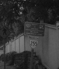
Creation: Appeared in July 1933 as a renumbering of US 340. Ran from US 340 Briggs to US 50 (curr SR 723) Millwood. This has been the only VA 255.
| Adjustments: VA 255 was extended south to current US 50 between 1942-44. Posting: Fully posted; cutouts at Millwood; error US 255 sign on US 340 NB Comment: A quaint sleepy shortcut between US 340 and US 17/50  |
|||||||||
|
|
|
| ROUTE LOG |
US 11: 0 - 0 I-81 (exit 235): 0.5 - 0.5 VA 276: 1 - 1.5 RH-AU LINE: 5 - 6.5 US 340: 0.5 - 7
|
Creation: Appeared in July 1933 as a renumbering of VA 812. Originally ran from VA 42 Mossy Creek to US 11 Burketown. This has been the only VA 256.
| Adjustments: VA 256 was extended east over SR 770 to VA 12 (curr US 340) Grottoes between 1942-44. VA 256 west was truncated to US 11 in 1952, leaving behind SR 646. Posting: Fully posted Comment: Where VA 256 WB left US 11, there is a small triangle. Could this have been VA 256Y? |
|||||||||
|
|
|
| ROUTE LOG |
I-81 (exit 240): 0 - 0 US 11: 1 - 1 VA 42 SB: 3 - 4 VA 42 NB, BEGIN VA 42 Bus: 3 - 7 VA 42 Bus, NB: 1 block - 7 SR 924: 12 - 19
|
Creation: Appeared in July 1933 as a renumbering of VA 813 and VA 838. Originally ran from Hone Quarry to 3 miles east of US 11. This has been the only VA 257.
| Adjustments: VA 257 east of US 11 was downgraded to SR 682 between 1945-47. VA 257 was re-extended east to I-81 in 1967. Posting: Very well posted, even out towards its western end. Comment: Passes through Bridgewater College. SR 924 beyond VA 257 looked very scenic when I drove to there a couple years back. Dan F has recently explored SR 924 and beyond: Eventually 257 became SR 924 and became a 1-lane gravel road. At an unmarked intersection I had to turn left to go up the mountain. Since it wasn't marked, I turned left going home instead right, and the gravel road ended up in West Virginia. The road ended in Franklin County, WV at SR 10, I think. The road I was on was posted with a WV SR # and called Reddish Knob Road at its terminus. I turned left and luckily, the way to US 220 was well posted. There is no sign where the VA/WV border is, and there are no end-state maintanance signs either along SR 924 so I don't think it becomes a private road or a Park Service or Forest Service road (though other roads in the area are marked with Park Service Route Number signs). There are no 924 signs except right after 257 turns into 924 and no WV route signs until it ends at SR 10. |
|||||||||
| US 258 |
| VA 258 not currently assigned | ||||||||||||||||
| Previous VA 258's: |
VA 258 #1: Appeared in July 1933 as a renumbering of VA 816. Ran from VA 340 (curr US 340) Grove Hill to VA 340 (curr US 340 Bus) Alma. This was renumbered to VA 158 in 1941. Today it is SR 650.
VA 258 #2: Appeared in 1941 as a renumbering of VA 158. Ran from US 58-258 Franklin to Rescue (east of VA 10 Smithfield). By 1944, VA 258 was rerouted at Smithfield, to the James River Bridge and over to Fort Monroe. Most of the Hampton-Newport News side was new construction. Also in 1942-44 the piece between Smithfield and Rescue became VA 152 #2. (Today it is SR 704). VA 258 was upgraded to US 258 between 1945-47. |
|||||||||||||||
|
|
|
| ROUTE LOG |
US 258 Bus: 0 - 0 VA 10 Bus: 0.48 - 0.48
|
Grace St. and a one-block section of Thomas St. Only connects to US 258
Bus. and VA 10. Unsure how long this has been here - a reference appears in the May 1979 CTB minutes.
| Posting: Fully posted. A. Froehlig in June 2005 reports a US 258 ALT shield at US 258 Bus. |
|||||||||
|
|
|
| ROUTE LOG |
I-81 (exit 257), US 11: 0 - 0 VA 42 SB, VA 259 ALT: 5 - 5 VA 42 NB: 0.5 - 5.5 VA 259 ALT: 0.5 - 6 WV STATE LINE: 15 - 21 WV STATE LINE: 0 - 21 US 50: 5 - 26
|
Creation: Appeared in July 1933 as a renumbering of VA 817. Ran from Athlone (3 miles east of US 11) to Broadway to then-WV 58. This has been the only VA 259.
| Adjustments: In 1941, the VA 259 section off US 50 Gore to WV was in place, replacing VA 275. Between 1945-47, VA 259 south was truncated to US 11, leaving behind SR 608. Posting: Fully posted; cutout still up at VA 42, I believe. Comment: VA-WV 259 is a very scenic, yet non-twisty route through the mountains. |
|||||||||
|
|
|
| ROUTE LOG |
VA 42, VA 259: 0 - 0 VA 259: 0.72 - 0.72
|
N. Main St. & Broadway Ave. Probably should be Business VA 259. State maps are unclear about when it formed or if this was VA 259 before, but it is on the 1961 Rockingham County Map, and mentioned in August 1949 CTB Minutes. VA 259 ALT is very well posted.
| |
|||||||||
| VA 260 not currently assigned | ||||||||||||||||
| Previous VA 260's: |
VA 260 #1: Appeared in July 1933 as a renumbering of VA 818. Originally ran from VA 4-42 (curr US 33-VA 42) Harrisonburg north to VA 261 (curr VA 42) Columbia Furnace, with a small gap near VA 263. The two pieces were connected by 1937. This was replaced in its entirety by an extended VA 42 between 1948-50.
VA 260 #2: Appeared in 1953 as an upgrade to SR 617. Ran from VA 42 Timberville to US 11 New Market. In 1954 or 1955, VA 260 was rebuilt west of New Market on a newer alignment to meet VA 42 a little south of its original jct. The old alignment went back to being SR 617. As early as 1967, VA 260 between I-81 to US 11 may have been changed to US 211. The rest of VA 260 became VA 211 in 1978. VA 260 #3: Appeared as a newly numbered route in 1990. Ran only about halfway from US 58/VA 189 to US 58/258 east of Franklin. The other half was under a very slow construction. I don't know if VA 260 was ever formally completed to US 58 Bus-258, but A. Froehlig reports that in the summer of 2003, this VA 260 was completely replaced by US 258 as its bypass of Franklin. |
|||||||||||||||
|
|
|
| ROUTE LOG |
US 11: 0 - 0 US 250: 1 - 1 VA 254: 1 - 2 US 11: 0.5 - 2.5 COALTER ST: 0.5 - 3
|
Creation: Appeared in 1981 in its present form. This was not previously numbered and is the 3rd VA 261.
| Adjustments: Possibly only exists on the 3/4 mile stretch above US 11 bypass. This may have happened in 1999 or 2000. Posting: I drove all of VA 261 since Jan 2002, and there are no VA 261 signs left. VA 261 was very well posted until 1999. Comment: VA 261 is still listed as active on the VDOT route log. However, it is designated in the field as US 11 Truck and US 250 Truck. Statler Blvd. from Coalter St. to Greenville Ave. (US 11) | Previous VA 261's: |
VA 261 #1: Appeared in July 1933 as a renumbering of VA 824. Ran from Woodstock Gap (east of Woodstock) west through Woodstock, and ended at VA 260 (curr VA 42) Columbia Furnace. By 1937, VA 261 west was extended over new routing to then-WV 59. VA 261 was renumbered as VA 59 #3 in 1941. Today, from WV to Columbia Furnace is SR 717-781; Columbia Furnace to Woodstock is VA 42; east of Woodstock is SR 785.
VA 261 #2: Appeared in 1941 as a renumbering of part of VA 3, running from US 522 Winchester north to the WV line. This was downgraded to SR 739 in 1952. |  VA 261 in 1941. |
||||||
|
|
|
| ROUTE LOG |
I-81 (exit 220): 0 - 0 US 11: 1 - 1 VA 252: 2 - 3
|
Creation: Appeared as a newly constructed route in 1982. The 1982-83 map shows this as not a freeway. Ran from I-64/81 to US 11. This is the 2nd VA 262.
| Adjustments: VA 262 was upgraded to a freeway by 1984. VA 262 was extended to VA 252 in late 2001. Posting: Fully posted Comment: Is being extended further west to US 250-VA 275 jct. IMHO, when that happens, either 262 or 275 should be eliminated. | Previous VA 262's: | VA 262 #1: Appeared in July 1933 as a renumbering of VA 819. Ran from VA 260 (curr VA 42) Forestville to US 11 north of New Market. This was downgraded to SR 767 between 1948-50. | |||||||
|
|
|
| ROUTE LOG |
US 11: 0 - 0 VA 42: 6 - 6 END VA 263: 7 - 13
|
Creation: Appeared in July 1933 as a renumbering of VA 820. Ran as it does today. This has been the only VA 263.
| Adjustments: None Posting: Fully posted; may still be a cutout at US 11. Comment: Blown-off by I-81; Orkney is the site of the Shenandoah Music Festival. |
|||||||||
| I-264 |
| VA 264 not currently assigned | ||||||||||||||||
| Previous VA 264's: | VA 264: Appeared in July 1933 as a newly numbered route. Ran from VA 259 near the WV line to Bergton/Dovesville. This was downgraded to SR 820 between 1954-55. | |||||||||||||||
| VA 265 not currently assigned | |||
| Previous VA 265's: |
VA 265 #1: Appeared in July 1933 as a newly numbered route. Was a spur off VA 263 Basye to Bird Haven. This was downgraded to SR 717 between 1942-44.
VA 265 #2: Appeared as a dotted line in 1980 as a newly constructed freeway bypass for Danville. Opened in 1982, running from US 29 at the NC Line to VA 86. VA 265 was extended to SR 737 in 1986, and extended again to US 58-360 by 1989. When the freeway was extended further around to meet US 29 north of Danville in 1998, VA 265 was renumbered as US 29. The current VDOT Route Log still shows VA 265 as active in its final incarnation, but it also has a VA 785 as active on the same freeway. In the field (last driven in 2001) it is sign only as US 29 and there is one "future I-785 corridor" sign in each direction. So I believe VA 265 is not in existence. In true VDOT tradition, the 1982-83 state map shows this as US 265. | ||
| I-266 |
| VA 266 not currently assigned | |||
| Previous VA 266's: | VA 266: Appeared in July 1933 as a renumbering of both VA 821 and VA 836. Ran from VA 12 (current US 340 Bus) Stanley through Ida and Stony Man to Luray, then continued northwest to the Shenandoah River. Between 1934-37, VA 266 south was truncated (and replaced by) to VA 231 (curr SR 689) Marksville. Between 1945-47, VA 266 northwest of Luray was downgraded to SR 678 and VA 266 was extended over VA 231 at Markston to VA 12 (curr US 340 Bus) Stanley. VA 266 was downgraded to SR 685 in 1953. | ||
|
|
|
| ROUTE LOG |
US 15, VA 7: 0 - 0 VA 28: 13 - 13 FX-LO LINE: 0.5 - 13.5 VA 7: 10 - 23.5 I-495 (exit 45): 2 - 25.5 VA 123: 0.5 - 26 I-66 (exit 67): 2.5 - 28.5
|
Creation: Appeared in 1984 as a new toll road that ran from VA 28 Dulles to VA 123 Tysons Corner. This is the 2nd VA 267.
| Adjustments: VA 267 was extended west to US 15-VA 7 Leesburg in 1995. Posting: Fully posted; On the approaches from both sides at US 15-VA 7, a borderless button is used on a white sign, giving an odd effect. Comments: VA 267 has the free Dulles Access Road (opened 1962) running in its median. A rather unique road split in two distinct parts. East of Dulles Airport is the Dulles Airport Road and Toll Road. The older inner lanes are free and allow you to go only to/from the airport. The outer lanes are toll and have regular interchange access. Ramps allow access between the roadways. If you miss your ramp coming eastbound on the inner roadway be prepared to go way, way out of your way (as I did once, how embarrassing). Toll booths and ramps are strategically situated so that airport traffic never has to pay, while non-airport always has to pay. Some people going to the Herndon area have attempted to avoid the tolls (and rush hour traffic) by entering the airport and U-turning, but I've been told the cops are watching for this (exactly how I don't know). West of VA 28 is the Dulles Greenway, a privately owned and operated toll road which was opened to much fanfare in 1995, and promptly became a tremendous flop. Various theories abounded most of which had to do with the outrageous tolls and low speed limit (55 MPH). As tolls have decreased (since rebounded to $2), and the speed limit and local development have increased, the road's use has gradually increased, although I believe it still lags behind the original projections. Although not a state highway, the Greenway is signed as VA 267 for continuity. For more information on this corridor, see Scott Kozel's website here. Signage oddities: Most of the Greenway's signs look exactly like normal road signs, although there's a few oddities as you might expect. Certain exits have special signs for housing developments. Also there seem to be a few more signs marking curves and other hazards than are absolutely necessary, such as turtle crossings. Liability limitation perhaps? :) | Previous VA 267's: | VA 267 #1: Appeared in July 1933 as a renumbering of VA 823. Ran from US 340 near Stringtown north to the WV line. This was downgraded to SR 611 in 1952. The 1947 VDOT map misidentifies VA 267 as VA 276. |  VA 267 in 1941. |
||||||
| VA 268 not currently assigned | |||
| Previous VA 268's: | VA 268: Appeared in July 1933 as a renumbering of VA 828. Ran from VA 18 (curr US 220) Clearwater Park to VA 501 (curr VA 39) near Bacova. VA 268 north was truncated to SR 615 Bacova Junction between 1945-47, leaving behind SR 621 (curr SR 687). The rest of VA 268 was downgraded to SR 687 in 1952. | ||
|
|
|
| ROUTE LOG |
I-64 (exit 29), US 60, VA 42: 0 - 0 I-64 (exit 35), US 60: 6.8 - 6.8
|
Creation: Appeared in 1984 as a renumbering of part of US 60. Ran as it does today. This is the 2nd VA 269.
| Adjustments: None Posting: Fully Posted Comment: Not sure why just 7 miles of old US 60 got to be VA 269. | Previous VA 269's: | VA 269 #1: Appeared in July 1933 . Began in 2 pieces 1. VA 501 (curr VA 39) Millboro Springs north about 10 miles (a renumbering of a part of VA 804 2. Williamsville north through McDowell to the WV line (a renumbering of VA 803). These 2 sections were connected in 1938. in 1953, VA 269 north was truncated to US 250 McDowell, leaving behind SR 654. The rest of VA 269 was downgraded to SR 678 between 1954-55. | |||||||
|
|
|
| ROUTE LOG |
US 58 ALT: 0 - 0 VA 63: 0.5 - 0.5
|
Creation: Appeared in the mid 90's as a renumbering of part of US 58 ALT. Ran as it does today and is the 2nd VA 270.
| Adjustments: None Posting: Fully posted; Apparently it isn't too short for VDOT to screw up the signage, as evidenced on H.B. Elkins' site (scroll down a ways) I believe this has been fixed. Comment: serves functionally as US 58 ALT Bus. | Previous VA 270's: | VA 270 #1: Appeared in July 1933 as a renumbering of part of VA 805. Ran from US 60 California to VA 501 (curr VA 39) Goshen. VA 270 was downgraded to SR 780 between 1948-50. i drove this in October 2001, and the alignment was great. This is a fine short cut from I-64 to Goshen, and should really be a state highway still. |  VA 270 in 1941. |
||||||
|
|
|
| ROUTE LOG |
US 250: 0 - 0 GO-HR LINE: 3.5 - 3.5 HN-GO LINE: 0.5 - 4 SR 620: 3 - 7
|
Creation: Appeared as a renumbering of VA 160 in 1941. Ran as it does now. This is the 2nd VA 271.
| Adjustments: None Posting: Fully posted Comments: Once out in the country, the lower half of VA 271 has been absorbed by the sprawling West End of Richmond. | Previous VA 271's: | VA 271 #1: Appeared in July 1933 as a renumbering of part of original VA 39. Ran from VA 18 (curr US 220) Vanderpool to WV 84. In 1941 VA 271 was renumbered as VA 84. | |||||||
|
|
|
| ROUTE LOG |
VA 189: 0 - 0 US 58, VA 189: 1.24 - 1.24
|
Creation: Appeared as a renumbering of part of VA 189 around 1989. Ran as it does today. This is the 2nd VA 272.
| Adjustments: None Posting: Fully posted Comment: South Quay Road. This is a wasted number...it should still be VA 189, while the stub of VA 189 from VA 272 to US 58-VA 260 jct should be part of VA 260. | Previous VA 272's: | VA 272 #1: Appeared in July 1933 as a renumbering of VA 829. Ran from VA 5 (curr US 250) West Augusta to just past Deerfield. In 1938 it was extended further west to SR 640 Armstrong. VA 272 was downgraded to SR 629 between 1948-50. | |||||||
|
|
|
| ROUTE LOG |
VA 30: 0 - 0 VA 30, VA 33: 5.33 - 5.33
|
Creation: Appeared in 1986 as a renumbering of part of VA 30. Ran as it does today. This is the 2nd VA 273.
| Adjustments: None Posting: Fully posted Comment: This is still faster to get from Williamsburg to West Point than current VA 30. | Previous VA 273's: | VA 273 #1: Appeared in July 1933 as a newly numbered route. Ran from VA 12 (curr US 340) Stuarts Draft to VA 5 (curr US 250) Fishersville. This was downgraded to SR 631 between 1948-50. Today it is SR 608 and all of VA 285. | |||||||
|
|
|
| ROUTE LOG |
US 58, US 221: 0 - 0 VA 94: 7.36 - 7.36
|
Creation: Appeared in 1981 as a renumbering of part of US 58-221. Ran as it does now. This is the 2nd VA 274.
| Adjustments: None Posting: Fully posted Comment: Follows the New River | Previous VA 274's: | VA 274 #1: Appeared in July 1933 as a renumbering of VA 833. Ran from US 11 Stephenson east to WV. This was downgraded to SR 761 in 1956. |  |
||||||
|
|
|
| ROUTE LOG |
US 250: 0 - 0 AU-STA LINE: 1 - 1 STA-AU LINE: 1 - 2 US 11: 2 - 4 AU-STA LINE: 1 - 5 I-81 (exit 225): 0.5 - 5.5 VA 254: 0.5 - 6
|
Creation: Appeared in 1968 as new construction. Ran only from US 11 to VA 254. This is the 3rd VA 275.
| Adjustments: VA 275 was extended west to US 250 about 1989. Posting: Fully posted Comments:Includes a northern bypass of Staunton. Most of VA 275 is also posted as US 250 Truck. See also VA 262. | Previous VA 275's: |
VA 275 #1: Appeared in July 1933 as a renumbering of VA 834. Ran from US 50 Gore south to then-WV 23. This was renumbered as part of VA 259 in 1941.
VA 275 #2: Appeared between 1942-44. Ran from VA 9 near Hillsboro north to the WV line near Harpers Ferry (US 340 did not run through Virginia to get from Harpers Ferry WV to Frederick MD at this time). VA 275 north was truncated to US 340 within Virginia in 1950. VA 275 was downgraded to SR 671 between 1954-55. VA 275Y: Appeared in 1948 or 1949 as new construction, running from VA 275 (curr US 340-SR 671 jct) to the Maryland State Line (curr US 340 crossing). VA 275Y was short-lived, and was renumbered as part of US 340 in 1950. VA 275Y was shown on the 1949 Official Map. |  VA 275 and 275Y in 1949. |
||||||
Previous: VA 226 - 250 |
Next: VA 276 - 300
Top | Virginia Hwy Index
Home
