
< 351 to 375 | Home | 401 to 425 > | 
Photo: The first thing newly freed prisoners see is the state committing route fraud (courtesy Rush Wickes) |
||||||||||||||||||||||||||||||||||||||||||||||||||||||||||||||||||||||||||||||||||||||||||||||||||||||||||||||||||||||||||||||||||||||||||||||||||||||||||||||||||||||||||||||||||||||||||||||||||||||||||||||||||||||||||||||||||||||||||||||||||||||||||||||||||||||||||||||||||||||||||||||||||||||||||||||||||||||||||||||||||||||||||||||||||||||||
|
|
|
|
|
Creation: NVCC Annandale began in 1967. This is the 2nd VA 376.
| Adjustments: None Posting: Posted with a shield at VA 236, white rectangles at other entrances and internally on campus Comment: What sets this route apart from others in the college series is that there are small 376 rectangles at not only each entrance to NOVA, but at all the internal intersections as well. I guess they want to make sure you know you're on VA 376. Russ Blau notes that this route does not appear in the latest (1993) VDOT county map book. It also has never appeared on any VDOT state maps. | Previous VA 376's: |
VA 376 #1: Appears in the CTB minutes a couple times in rewference to junction with route 251 (curr VA 7 Bus) Berryville. This implies that VA 376 was part of today's US 340 in the area. This could be a full or partial renumbering of VA 361 or partial renumbering of VA 37. More investigative work is needed with this one...
The 1928 Esso map shows north of Berryville as VA 378, but this is likely in error... |
||||||||
|
|
|
|
|
Creation: LFCC Middletown opened in 1970. This is the 2nd VA 377.
| Adjustments: None Posting: Don't recall one, but a white rectangle is possible Comments: Is a loop off US 11. Not found in 1993 VDOT atlas, but has been in others. | Previous VA 377's: | VA 377 #1: Appeared between 1924-27. Ran from VA 37 (curr VA 3) Oak Grove to Colonial Beach. VA 377 was renumbered to VA 611 in 1929. Today it is part of VA 205 and all of VA 205Y. |  |
|||||||
|
|
|
|
|
Creation: SVCC opened in 1970. This may not be the only VA 378.
| Adjustments: None Posting: Posted with advance junction markers on VA 46, and even a reassurance marker (sans direction) on the road itself. Comment: From Dave: Discovered while having detoured to see I-540 on my way back from Key West. Does not appear on official state maps. |
||||||||||
|
|
|
|
|
Creation: PDCCC appeared in 1971 or 1972. THis has been the only VA 379.
| Adjustments: None Posting: Unknown Comment: Located off SR 671 near the US 58 Bypass. |
||||||||||
|
|
|
| ROUTE LOG |
VA 156: 0 - 0 END VA 380: 0.78 - 0.78
|
Creation: not sure - could not find any info on Va. State Police website. By number assigned may go back to early 1970's.
| Adjustments: Was shortened in mid 90's - see comments below Posting: Fully posted Comments: Appears on official state map Richmond insets since 1981. It is several roads inside the facility. I received an e-mal from Bryan Harvey: A great portion of VA 380 was eliminated when the White Oak Technology Park was built between '97 and '98. Today it runs between VA 156 and Technology Blvd., which is a new road that was built to service the technology park. It's posted on both ends. Also, there is no State Police facility on VA 380, but rather a series of VDOT facilities (VDOT Materials Division, the Elko Area Headquarters and the Sandston Residency). |
|||||||||
| I-381 |
|
|
|
| ROUTE LOG |
US 11E SB, US 19 SB: 0 - 0 US 421 SB: 0.25 - 0.25 VA 113: 0.25 - 0.5 US 11, END US 11E, US 11W, US 19 NB, US 421 NB: 0.25 - 0.75 I-381 (no exit): 1 - 1.75
|
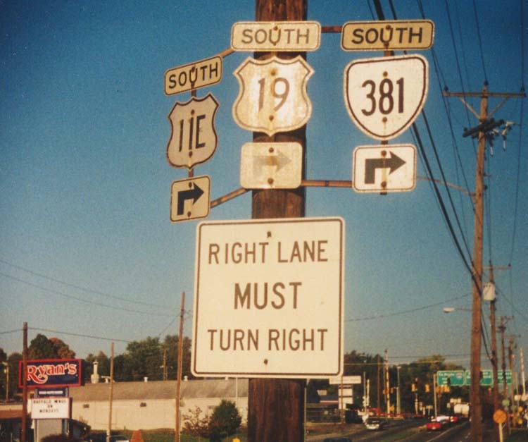
Creation: Appeared by 1961 (VA 381 is on the 1961 Washington County Map). Ran as it does now. This has been the only VA 381.
| Adjustments: None Posting: Fully posted; cutouts still existed until recently in Bristol Comment: If Virginia were to ever want a green interstate, this would work as green 381. VA 381 ends at State St, which is the Tennessee State Line |
|||||||||
|
|
|
|
|
Creation: Began in 1965 (CTB Minutes), although the history of school goes back to 1954. Began giving out full degrees in 1970. This has been the only VA 382
| Adjustments: Unknown Posting: Unknown Comment: For the hat trick...unknown. |
||||||||||
|
|
|
| ROUTE LOG |
VA 123: 0 - 0 END VA 383: 0.31 - 0.31
|
Creation: Appeared in 1965 (CTB Minutes). It once was (1957-72) a branch of the University of Virginia. This has been the only VA 383.
| Adjustments: None Posting: One shield on VA 123 NB. Comment: Shown on official map insets since 1978, but is shown erroneously as VA 303 from 1978-1993 (even though VMI is shown as VA 303 on maps from 1988-forward) |
|||||||||
|
|
|
| ROUTE LOG |
I-64 (exit 24), US 60, US 60 Bus, US 220, US 220 Bus: 0 - 0 END VA 384: 0.56 - 0.56
|
Creation: First opened as a community college in 1967. From 1964-67 it was a branch of Virginia Tech. This has been the only VA 384.
| Adjustments: None Posting: One reassurance shield at entrance; no mention from I-64; This shield was a cutout until at least 1993 - the only college route cutout I've ever seen. Comment: This is also the only college route with a direct exit from an interstate. At I-64 Exit 24: US 60/220 Bus. goes east, VA 384 goes west. |
|||||||||
|
|
|
| ROUTE LOG |
VA 40: 0 - 0 END VA 385: 0.34 - 0.34
|
Creation: This campus appeared in 1971 or 1972. This has been the only VA 385.
| Adjustments: None Posting: Dave reports in June 2002 that this is fully posted. Comment: Not in VDOT county map atlases, but is active in current VDOT log. Off VA 40 east of the Keysville Bypass |
|||||||||
|
|
|
| ROUTE LOG |
US 58: 0 - 0 END VA 386: 0.99 - 0.99
|
Creation: The prison opened in 1976. This has been the only VA 386
| Adjustments: None Posting: Fully posted at US 58. Rush Wickes reports it is not posted anywhere else. Comment: Appears on state official maps since 1988. I have seen a recent news item suggesting this facility could be going away. Rush also points out that the facility will remain in a different capacity (intake/classification center), so I suppose VA 386 will remain... |
|||||||||
|
|
|
| ROUTE LOG |
US 23: 0 - 0 END VA 387: 0.2 - 0.2
|
Creation: MECC opened in fall 1972. This has been the only VA 387.
| Adjustments: None Posting: Unknown, but I think it is because the campus map identifies the loop road as route 387. Comment: Located south of town |
|||||||||
|
|
|
|
|
Creation: PVCC opened at this location in summer 1973. This may have been part of VA 317 (Land was owned by the Blue Ridge Sanatorium) or may have been an F-series route. It is the only VA 388.
| Adjustments: None Posting: White rectangle at VA 20 Comment: Also provides access to the Thomas Jefferson Visitors Center. VA 388 is just south of I-64 and almost directly across the street from VA 317. VA 388 does not show up in Charlottesville insets of the official map, though there is room. |
||||||||||
|
|
|
|
|
Creation: Appeared about 1975. This has been the only VA 389.
| Adjustments: None Posting: Beige rectangle at US 13 observed August 2001. Was once white but is now very dirty. Comment: Off US 13 near Accomac Co. Airport. Does not appear on official maps. |
||||||||||
|
|
|
| ROUTE LOG |
US 58: 0 - 0 END VA 390: 0.13 - 0.13
|
b>Creation: Created in 1978. The fill dirt for the Holland Bypass came from this site. This has been the only VA 390.
| Adjustments: None Posting: Unknown Comment: Virginia has several of these agricultural extensions, but only 3 received state routes. |
|||||||||
|
|
|
| ROUTE LOG |
VA 7: 0 - 0 END VA 391: 0.17 - 0.17
|
Creation: Appeared in 1976. This is the 2nd VA 391.
| Adjustments: None Posting: In early 2003 I saw it is now fully posted in both directions from VA 7. In May 2005 there were 391 in shields from both directions on VA 7; there is no posting on the north end. 
Comment: Is on official map insets of Northern Virginia back to 1978. | Previous VA 391's: | VA 391 #1: Created in 1923 as a renumbering of a piece of VA 9 SPUR. Ran from VA 39 (curr US 60) Lee Hall to Yorktown. VA 391 was extended southeast to Messick later in the 20's. In 1927 US 17 was added to this route from Lee Hall to Yorktown. VA 391 went away in 1929, becoming just US 17, part of VA 514 and all of VA 516. Today it is most of VA 238, part of US 17, and most of VA 171. | |||||||
|
|
|
| ROUTE LOG |
SR 707: 0 - 0 END VA 392: 1.05 - 1.05
|
Creation: Unsure (website had no history). By its number it probably got started around 1976. This is the 2nd VA 392.
| Adjustments: None Posting: On nearby US 58-221 there are (at least in 1993) TO VA 392 signs with the 392 in a shield. Comment: Not on official state maps; just west of I-77. | Previous VA 392's: | VA 392 #1: Appeared in 1923 as a renumbering of a VA 9 SPUR. Ran from VA 39 (curr VA 5-VA 132 jct) Williamsburg to Jamestown. In February 1925 the ferry to Scotland opened, and VA 392 was extended through Surry to Dendron. All of VA 392 became VA 510 in 1929. Today it is most of VA 31 and VA 5 within Williamsburg. | |||||||
|
|
|
|
|
Creation: This campus opened in 1976. This is the 2nd VA 393.
| Adjustments: The entrance off VA 234 is now one-way Posting: White rectangle at VA 234 has been removed; unsure elsewhere Comment: Wedged in between I-66 and US 29 north of Manassas; Does not appear in official map insets. | Previous VA 393's: | VA 393 #1: Appeared in 1923 as a renumbering of part of original VA 9. Ran from VA 39 (curr US 60) Bottoms Bridge to VA 39 (curr US 60) Andersons Corner. VA 393 became VA 415 and VA 53 in 1929. Today this is VA 33, VA 273, and VA 30. | ||||||||
|
|
|
|
|
Creation: This campus appeared in 1977. This is the 2nd VA 394.
| Adjustments: None Posting: White rectangle at northern entrance from SR 638. Comment: Loop off SR 638 Neabsco Mills Rd, near Dale City exit 156 off I-95. | Previous VA 394's: | VA 394 #1: Appeared in 1923 as new routing. Ran from VA 39 (curr VA 143) Hampton to Buckroe Beach. VA 394 was renumbered as VA 512 in 1929. Today it is part of VA 169. |  VA 394 in 1928. |
|||||||
| I-395 |
| VA 395 not currently assigned | |||
| Previous VA 395's: | VA 395: Appeared between 1924-27. Ran from VA 39 (curr US 220-250 jct) Highland north to then-WV 28. VA 395 was renumbered as VA 800 in 1929. Today it is part of US 220. This was the highest 3-digit route number in the 1923-28 system. | ||
|
|
|
|
|
Creation: This campus opened in 1978. This has been the only VA 396.
| Adjustments: None Posting: Shields at each end; NOTE: On 6/8/02 I drove by on US 522-VA 6, which was under construction - the VA 396 sign here was removed! Thankfully, I have confirmed (Feb 2003) that the sign was put back at the end of the project. On July 10, 2004 I saw a new advance directional sign on VA 6 WB. Comment: Does not appear on official state maps; located just south of US 522 NB/VA 6 split. |
||||||||||
|
|
|
| ROUTE LOG |
US 301: 0 - 0 GV-SX LINE: 0.38 - 0.38 END VA 397: 0.62 - 1
|
Creation: The prison opened in 1990. This is the 2nd VA 397.
| Adjustments: None Posting: Fully posted at US 301; Rush Wickes reports that there was a US 397 sign at the prison for a while (see photo at top of page). Comments: Appears on official state maps since 1990. | Previous VA 397's: | VA 397 #1: Appears on the 1928 Official Map. VA 397 was a short run between US 60/VA 39 and US 17/VA 391 in the Lee Hall area. In 1929, this became VA 519. Today it is mostly obliterated by I-64 and the Yorktown Naval Weapons Station. |  VA 397 in 1928. |
||||||
|
|
|
| ROUTE LOG |
COLLEGE PARK RD: 0 - 0 KEMPER RD: 0.40 - 0.40
|
Creation: DCC opened in 1967. Previously it had been a textile school back to 1936. I do not know if 398 was assigned in 1967 or later. This has been the only VA 398.
| Adjustments: None Posting: Unknown Comment: Road connecting Kemper Rd. and College Park Dr. |
|||||
|
|
|
| ROUTE LOG |
US 33, US 250: 0 - 0 US 33, US 250: 0.11 - 0.11
|
Creation: I believe the museum opened around 1980. The building was the 1919 train station. This has been the only VA 399.
| Adjustments: None Posting: None Comment: Forms loop off US 33-250 Broad St. near Robinson St. I had thought VA 399 (which is in VDOT city atlas) was for the state police HQ which is very nearby, but the VDOT route log says it is for the museum. |
|||||
