undefined
| ||||||||
|
Kent's Nav Bar
|
Global Positioning Satellite Receiver (GPS) is a great navigational aid. Having the ability to connect to your computer and transfer data back and forth makes it even more useful. Add to that USGS Maps on CD and the ability to interface your GPS data, and you have computerized navigational system. I have found reasonably priced products that will amaze you. DO NOT rely on a GPS as your loan navigation means. Map & Compass knowledge, experience, and all appropriate survival and backcountry emergency equipment should be included in your travels. Be Safe, Plan Well! (Click Here for Back Country Notes)
There are several good GPS units available. I recommend at least a 12 channel unit that is compatible with OziExplorer and has an interface cable available. Keep in mind button locations if you are planning on using your GPS with a heated snowmobile mount or other mount. (Some units have the buttons on the sides, which might be inaccessible when in mount.) Garmin and Magellan both make a variety of GPS units. If considering a GPS that has on board maps, be sure to check for map compatibility and available Alaskan coverage. (I have used the Garmin 12 for years, but am considering upgrading to the newer 76CSx.)
You want to be sure that your GPS has a computer interface cable available, and that you have the proper port to plug into on your computer. [Top] [Back to What You Need ] [Back to Links Page] I investigate applications from free shareware to $500 packages. I found OziExplorer as the easiest to use, full featured, and responsible price application. Available on line for $75, with free updates as they become available. It interfaces with many of the popular GPS units and map formats. Allows creation, editing, and storage of maps, waypoints, track logs, and routes. Transfers data between computer and GPS, and interfaces with USGS Maps on CD. You can get USGS Maps on CD at the USGS Map Office, however they must be special orders, and you will be charged a $40 set up fee plus $1 per map. Another source for USGS Maps of Alaska on CD is GPS Trails. They sell USGS Maps on CD for $25 per disc, plus $5 S&H. There is a total of about 40 discs for the entire state of Alaska, however you can buy just the disks you want. [Top] [Back to What You Need ] [Back to Links Page]
This is a handy little device that connects to your GPS and stores huge amounts of track points. Without it you will find that you may run out of track points on relatively short trips, which is frustrating. With it you can capture track data for days. The only catch is that you cannot access the datalogger data from your GPS you have to download from the logger to a computer. Once downloaded you can manulipate the track log, break it into sections, reduce the number of track points and reload it to your GPS or view it on maps allowing you to create waypoints or notes. In 2002, 2005, 2006, I used a datalogger to capture the entire 16 day, 800 mile Serum Run, complete with speed, altitude, date & time, location & heading, very impressive!!. Check my my DataLogger page for more detailed information on the DataLogger. Or visit Rob Keskull's DataLogger page.
[Top] [Back to What You Need ]
[Top] [Back to What You Need ]
[Top] [Back to What You Need ]
[Top]
[Top]
Kent's Suggestions Buying A GPS I've played with Megallan and Garmin GPS's, and liked the Garmin menus better. Garmin seemed to have easier menu navigation and the buttons where easier to operate. I currently have a Garmin 12 handheld GPS that I like. If you think you may be using your GPS in a mount, which I highly recommend for snowmobiling, be sure the buttons will be accessible when in the Mount. The new Garmin etrex™ has buttons on the side, which would be inaccessible in the style of heated mount that I have.
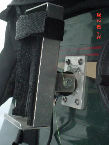
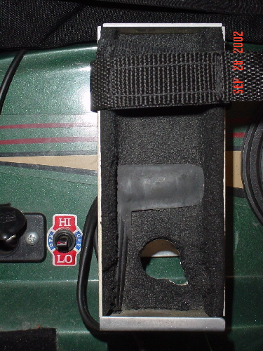
I consider a heated snowmobile mount a must. Keeps you GPS warm and up where you can see it and reach it. When riding it's much easier to be able to glance at the dash and see your GPS screen. You'll find it makes entering waypoints on the go quick and simple, besides what good is it in your pocket unless you stop and dig it out to use it. (Just tether a stick or dowel rod to the mount and you have an easy way to push the buttons with mittens on.) The first time you travel with your GPS on the dash you'll be convinced.
Mounting the Mount Try to locate the mount where the GPS will be visible while driving, and within reach. Be sure that your handlebars, knees, and anything else clear it in all positions. Try to mount it low enough that if the machine rolls your GPS will be somewhat protected. Don't wire it directly to your battery, if you forget to turn it off it will drain your battery. [Top]
Using OziExplorer This section is to be developed yet. [Top]
Both ATV's & Snowmobiles offer us the chance to visit remote parts of Alaska, also the chance to get real into trouble. Besides the many opportunities for accidents and injuries along the trail, there is plenty of opportunities to get lost a long way from civilization.
While a GPS is a great navigational aid, and gives us the ability to track, save & share our trails, it should not be relied on as your only means of navigation. The GPS is based on map & compass navigation, so it is essential to know how to use a map and compass before you can truely use a GPS. For basic users, you can keep a track log and set waypoints as you travel, and then follow the same track back to where you start. (Keep in mind accuracy can be off by more than 100 feet) But, GPS's like everything else, can get broken, or lost, and batteries go dead. At least be familiar with map and compass and be able to pick land formations from a topo map. A good book is 'Be Expert With Map & Compass' by Bjorn Hjelistrom. (Available at Amazon.com) [Top] Leave a Trip Plan: Just like pilots log flight plans, you want to let someone know where you are going, at least the general area, and when you should be expected back. If you don't show up, they can call the State Troopers and give the information needed to assess and assists. With OziExplorer you can even print out a Trip Plan Map, with all your expected route of travel, waypoints, and notes. When you've planned your trip and done the maps, just print out a general map of the area with waypoints, routes, tracks, and any other items, scribble your expected date of return, and leave it with someone, poof, instant trip plan.
Put together and Carry a personal Survival Kit. Put together you own survival kit. Store bought kits contain some good basic items, but I don't think you'll need the fish hooks and line in the winter. Think of what is important to your survival in a bad situation. First Aid, Navigation, Fire, Signaling, Food, Water. Take time to research survival. Read survival guides and manuals to get an idea of what you should carry and how to use it.
Here are a few things I carry in my personal survival Kit. (Not intended to imply this is a complete survival kit, just some of the things I carry.)
Put it all in a nice little stuff sack you have a kit you can carry with you just in case. [Top]
Avoid traveling Solo. If traveling alone, keep in mind how far you can walk the distance you've traveled, Be prepared to do so if you break down or loose your machine. My rule it to not go farther than I can walk out in the time remaining in the day, or be prepared to spend the night on the trails. Food, water & appropriate extra clothing, along with survival and signaling gear at a minimum. Traveling more than 10 miles into the wilderness by snowmobile can take less than 20 minutes, yet to cover that same snow on foot or snowshoe could take the better part of a day. Keep in mind changing snow and weather conditions. (Walking a hard pack trail is easier than plodding through deep powder.) Besides the travel aspect, in the event of accident or injury it's nice to have someone along that can assist.
[Top]
|
|
| |||||